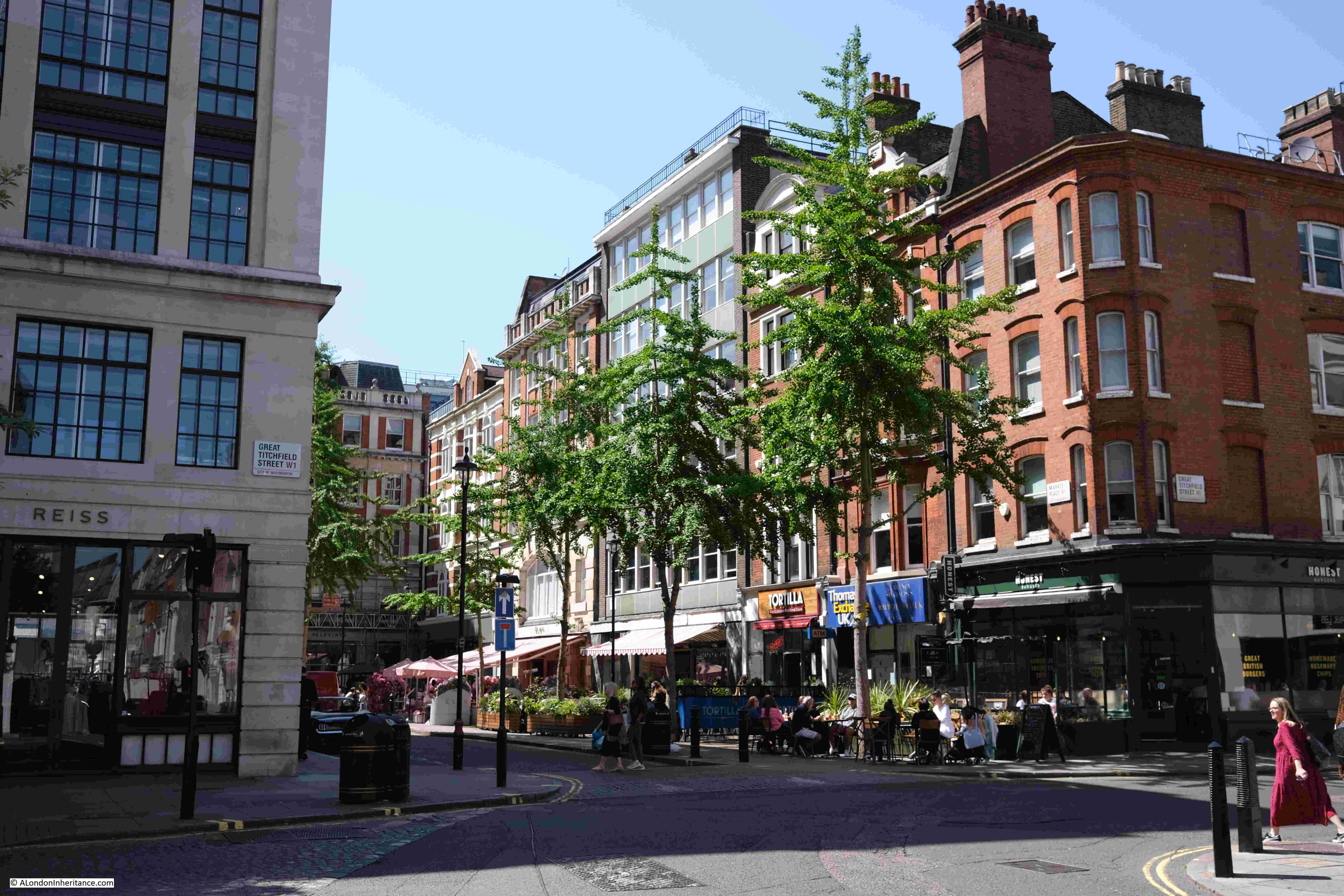
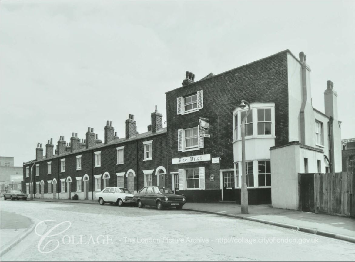
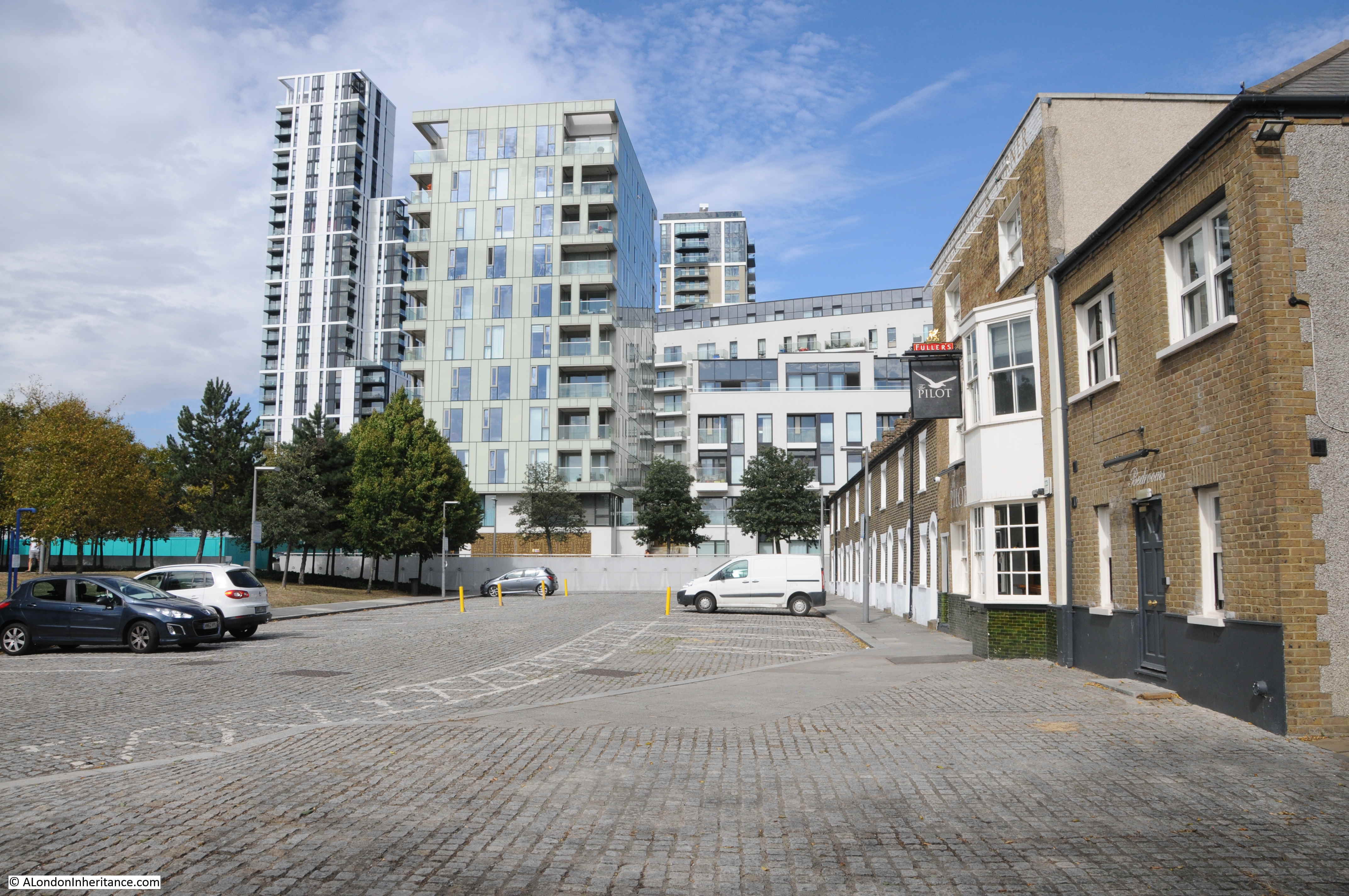
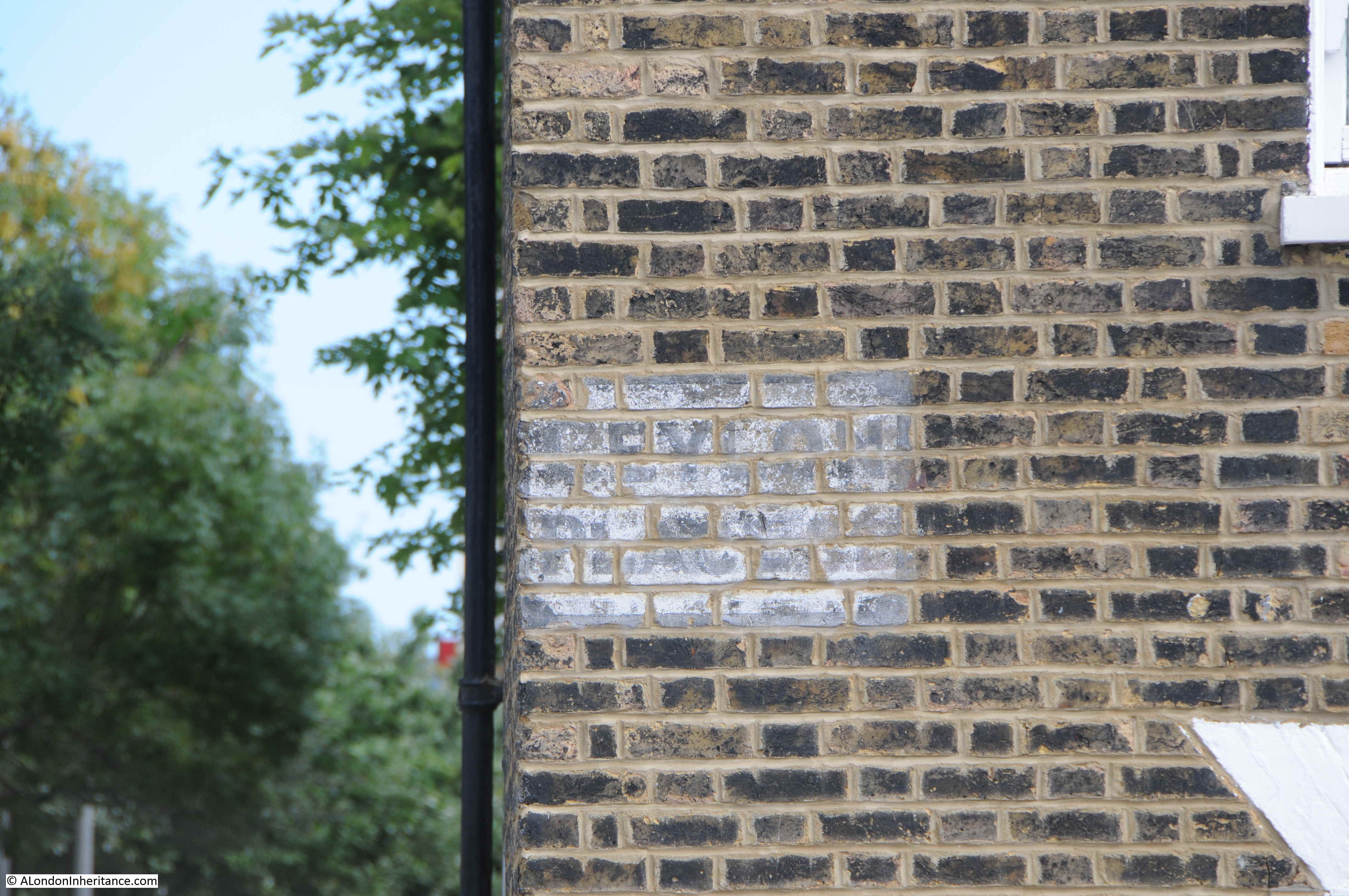
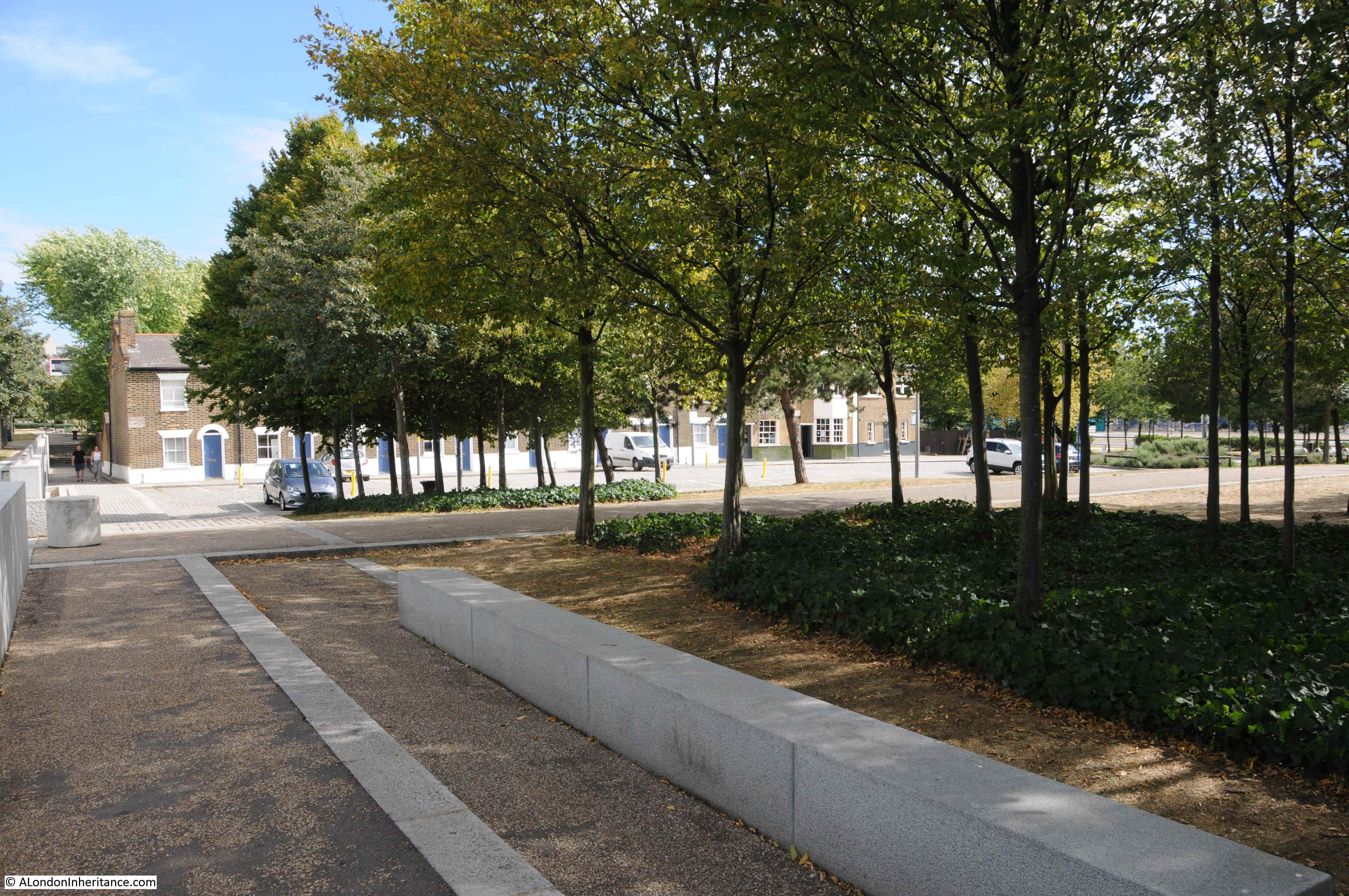
Just a relatively short post this Sunday as during the last week, all five days were on Jury Service, but it does give me the opportunity to continue the series of posts I started last August, looking at the pubs of Soho, and for part three, I am starting with:
The Spice of Life – Moor Street
The Spice of Life occupies a prominent position, at the end of two streets (Moor Street, to the right in the above photo, and Romilly Street to the left), and facing onto Cambridge Circus. In the over 200 years of the pub’s existence, it seems to have swapped the Moor Street and Romilly Street names, as the location of the pub, with today Moor Street being the address.
The pub seems to date from the late 18th century, when it was originally called the George, or the George and Thirteen Cantons, however I suspect the current building dates from the late 19th century and is of very similar architectural style to the Cambridge which I will look at next.
I cannot find any firm reference to this name, apart from it being used in a for sale advert in 1892 when it was listed as a “freehold property known as the George and Thirteen Cantons”.
The pub had a very similar, unusual name to another Soho pub, the Sun and 13 Cantons in Great Pulteney Street, and I assume the source of the name is the same for both, and from the Swiss watch-making community that lived and worked in Soho in the late 1800s.
By 1935, the pubs was known by two names, still the George and Thirteen Cantons, but also now the Scots Hoose.
I found this in newspaper reports on the 28th of September, 1935, where details of the will of a former licensee where given, as:
“John Ingram Moar, of ‘The Scots Hoose’, Cambridge Circus, London, licensee of ‘The George and 13 Cantos’, better known as ‘The Scots Hoose’ in Soho, who had been a licensee in the West End of London for over 50 years. Net personality £29,566; gross, £30,314.”
The George and 13 Cantons name seems have disappeared by the 1950s and 1960s, where the only reference to the pub is as “The Scots Hoose”, and a 1966 review in the Tatler provides an glimpse of the pub:
“The Scots Hoose, Romilly Street. Not surprisingly, the landlord, ‘Jock’ Ansell, is a Scot. He is a retired musician and has worked with such stars as Jack Hylton and Bruce Forsyth. His pub was once the haunt of the Crazy Gang. Nowadays he prides himself on the finest selection of whiskies in Soho. You can buy a nip of Glen Grant (100 degrees of proof malt whisky) for 3s 6d. Gold painted thistles decorate the walls, but otherwise the atmosphere is disappointingly English, with a recurring chant of ‘arf a bitter, guv'”
The description of the pub as “disappointingly English” does not do justice to the Scots Hoose of the 1960s, as it was a popular and well know music venue, as we find in the Stage from the 31st of August, 1967:
“In another popular North of the Thames pub, the Railway Tavern of Tottenham, the Kevin Lindsay Organ Trio has taken up residence, and in the West End’s only music-hall pub, the Scots Hoose, Cambridge Circus, Doreen Ansell has captured Wakefield born pianist Barry Booth, former MD for Roy Orbison, to provide the backing for popular residents Tommy Osborne and Roy Tierney.”
I do not think the description of the pub as a “music-hall pub” is that accurate, rather it was a pub which hosted live music, not traditional music hall acts, and in the 1960s and early 1970s, the Scots Hoose was one of the London pubs where many of the rising acts of the British Folk revival could be regularly found.
A regular was Bert Jansch, a Scottish Folk musician who had moved down to London, as well as Folk performers such as Ralph McTell, Richard Thompson and Sandy Denny.
One of Sandy Denny’s early home recordings was a song called Soho, a lyrical description of mid-1960s Soho, with the first few lyrics:
Come walk the streets of crime And colour bright the corners Of love with the earth
See the dazzling nightlife grow Beyond the dawn and burning In the heart of Soho
Hear the market cries And see their wares displayed Through the window of your soul
From Sandy’s performance of the song on Youtube:
The pub had changed name to “The Spice of Life” by the early 1980s, and as well as music, the pub seems to have been hosting plays, as there are adverts for these, with, for example, the following from “The Stage and Television Today” in March 1983:
“A COUPLA WHITE CHICKS SITTING AROUND TALKING, BY John Ford Noonan. Spice of Life, Cambridge Circus WC2 to March 26. Cast includes, Monica Buferd, Lynn Webster, Director Siobhan Nicholas”
Today, the Spice of Life is still an active music venue, with a regular Jazz Club, Blues, Soul and occasionally other types of acts such as Comedy performances.
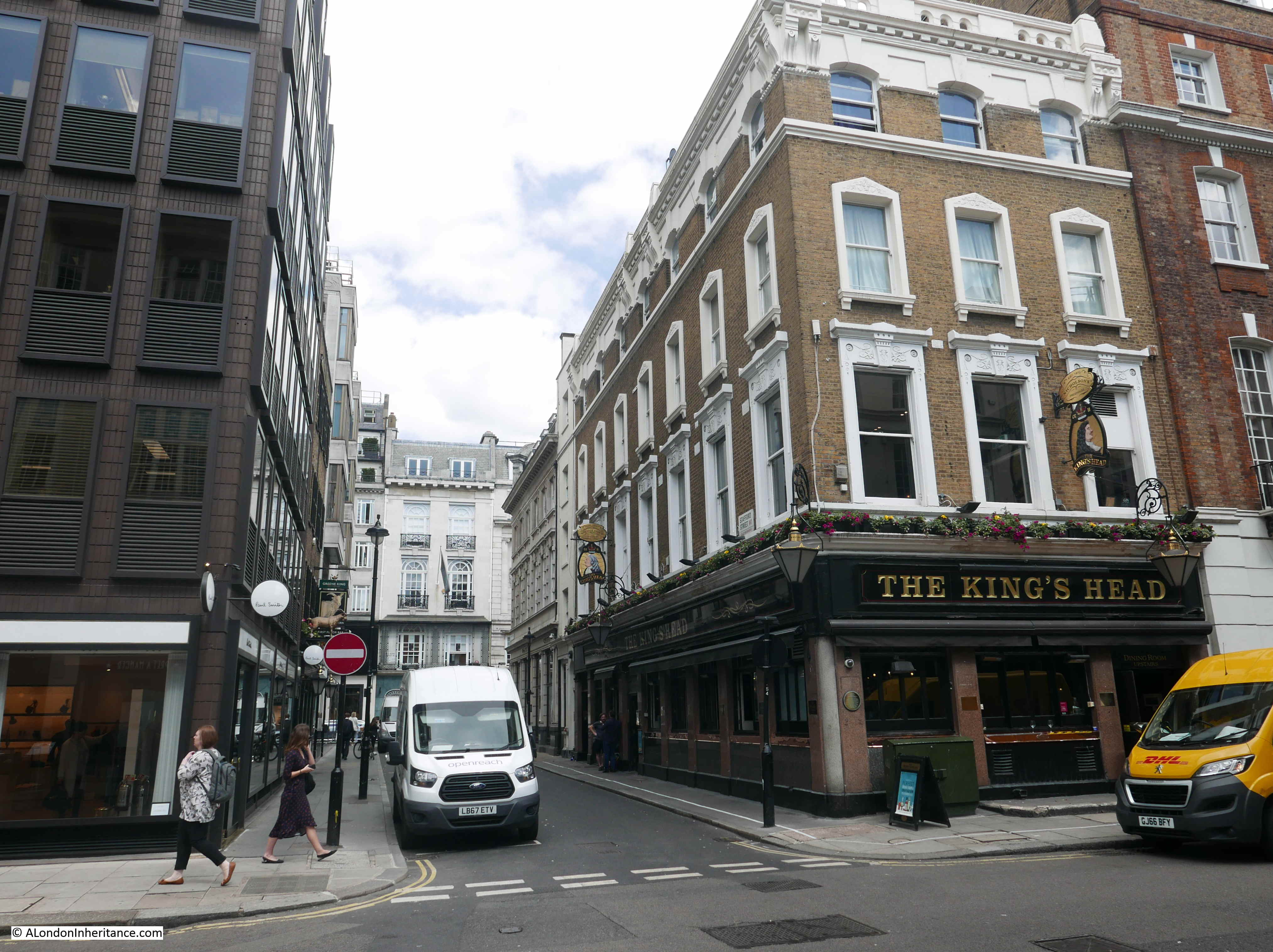
The Cambridge – Charing Cross Road
The Cambridge is on the other side of Moor Street to the Spice of Life, but where the Spice of Life is slightly set back from Cambridge Circus, the Cambridge faces directly onto Cambridge Circus, and the pub has a Charing Cross Road address.
The building dates from 1887, and seems to have been part of the construction of Charing Cross Road, which also included the build of Cambridge Circus, although the pub was built on the site of a previous pub which went by the name of the King’s Arms.
Cambridge Circus is named after the Duke of Cambridge who officially opened Charing Cross Road on Saturday 26th February 1887, and the pub seems to have followed the same naming route, following the change from the King’s Arms.
Whilst the Cambridge has the usual news reports about the type of low level incidents and events, typical of Soho, in August 1991, the pub was part of the latest campaign of bombings by the IRA. The following is a typical news report from the time:
“A pub landlord said today he was shocked to learn he may have been the victim of an IRA firebomb attack. ‘The Cambridge’, in the heart of London’s West End, was badly damaged in the attack eight days ago.
But police have only just disclosed that the fire was likely to have been the work of the IRA.
Landlord John Pucci (50) said, ‘Police Officers came here and told me they thought the IRA was involved. It was a bit of a shock to say the least.
I don’t know why they picked on this pub. It’s not an Irish pub, or a police pub and we don’t hold meetings of any kind. It’s very much passing trade, tourists and people going shopping. I imagine the idea was purely to disrupt the West End.
Mr. Pucci, who has run ‘The Cambridge’ on the corner of Cambridge Circus in Charing Cross Road for five years said he was woken by the fire alarm at 7:15 am. When he opened the door between his flat and the top bar he was met by sheets of flame.
He said his wife Nina, his 20 year old son Julian and assistant manager Andrew Prime got out through the second-floor window only by climbing down a fire brigade ladder. Another five minutes and we would have been goners, he said.
The blaze completely gutted the top bar – the fire was so intense a television 25 feet from where the device was stuffed behind a seat, exploded.
Surveying the damage estimated at £200,000, Mr. Pucci said, ‘If it had gone off in the evening there would have been a few people roasted’. Remains of the device, about the size of a cassette tape, were found to be similar to incendiary bombs abandoned at Preston railway station in April.
Detectives believe the same kind of device triggered fires in several shops in the centre of Manchester.”
The bomb at the Cambridge was not the only time that Charing Cross Road was targeted during the IRA’s 1991 bombing campaign as later that year, in September, a similar incendiary bomb, but this time unexploded, was found in the Bargain Books of Oxford bookshop.
Thankfully, not all events in Soho’s pubs have been so potentially devastating.
Coach and Horses – Old Compton Street
The Coach and Horses on the corner of Old Compton Street and Charing Cross Road is interesting as it did was not originally built as a pub, but, as described in the details of the Grade II listing, is a “Rare survival of early house representing the earliest phase of Soho’s development”, and that it dates from the “Late C17/early C18 with later alterations”, so as the listing states, it really is a rare survivor from the first stages of Soho’s development.
I cannot find exactly when the building changed from being a residential house to a pub. The pub’s website states that it dates back to 1731. The first written reference I can find to the pub is rather confusing. It dates from the 3rd of December, 1814, where in the Durham County Advertiser, there is an advert. At the top a drawing of a stage coach with horses on the road, below which is written:
“The old established and original CITY OF DURHAM HOUSE, COACH AND HORSES, LITTLE COMPTON STREET, SOHO, LONDON. William Hopper (Late of the City of Durham) returns his most grateful thanks for the favours he has been honoured with since his Uncle’s death , and begs to informs his friends, countrymen and the public in general that very comfortable accommodation is afforded for their comfort. Wines and spirits of the best quality. Good beds are provided for his friends. Exclusive of the London papers. he takes in those of York, Durham, Newcastle and Dumfries.”
I am really not sure what this advert means. Is “City of Durham House” a sort of additional trading name for the Coach & Horses, which may have been the point where a coach service to the north east operated from (although I can find no other evidence of this, but it would explain the name of the pub), and which provided accommodation for those arriving from, or departing to the north east?
I have no idea, just one of those little historical mysteries. Note though that in the advert the pub was in Little Compton Street, which was the original name for the street prior to the construction of Charing Cross Road and the rename to Old Compton Street.
Although the pub still retains its original name, it has had a couple of name changes, first to Molly Moggs, in 1996, when it was one of Soho’s gay pubs, then in 2017 it changed to the Compton Cross, and following the purchase of the pub by Shephard Neame in 2019, along with a major restoration, the name returned to the original Coach and Horses.
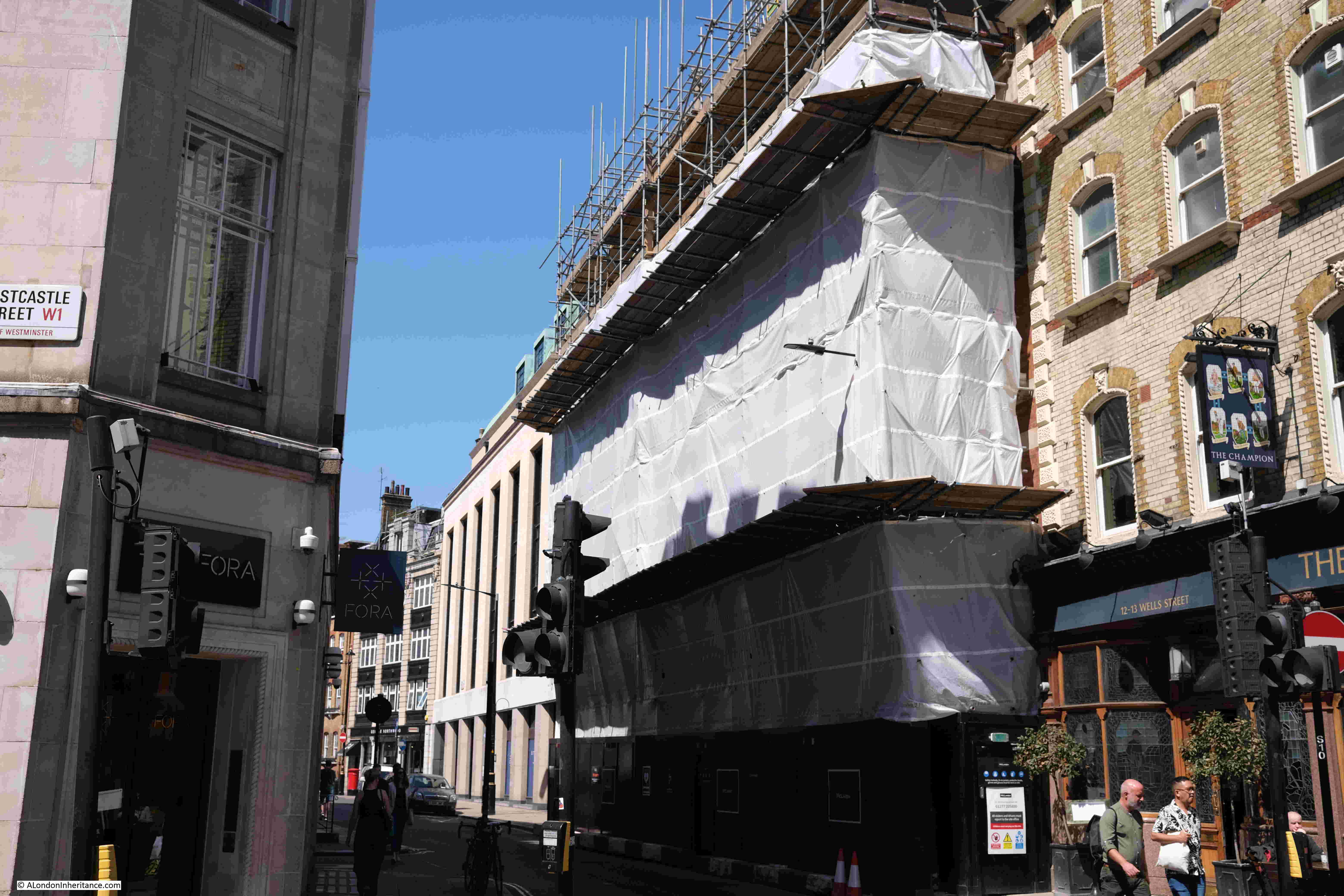
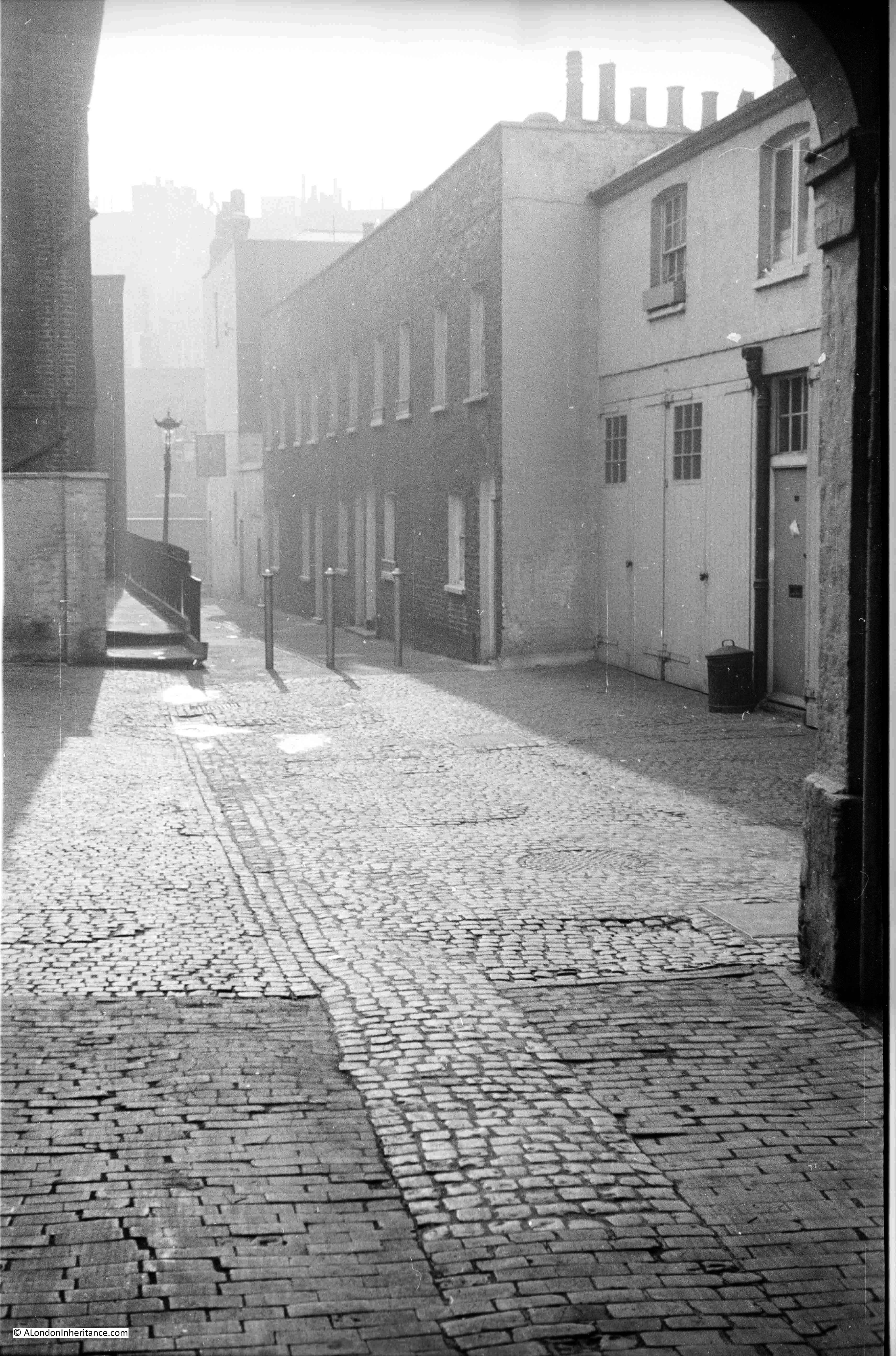
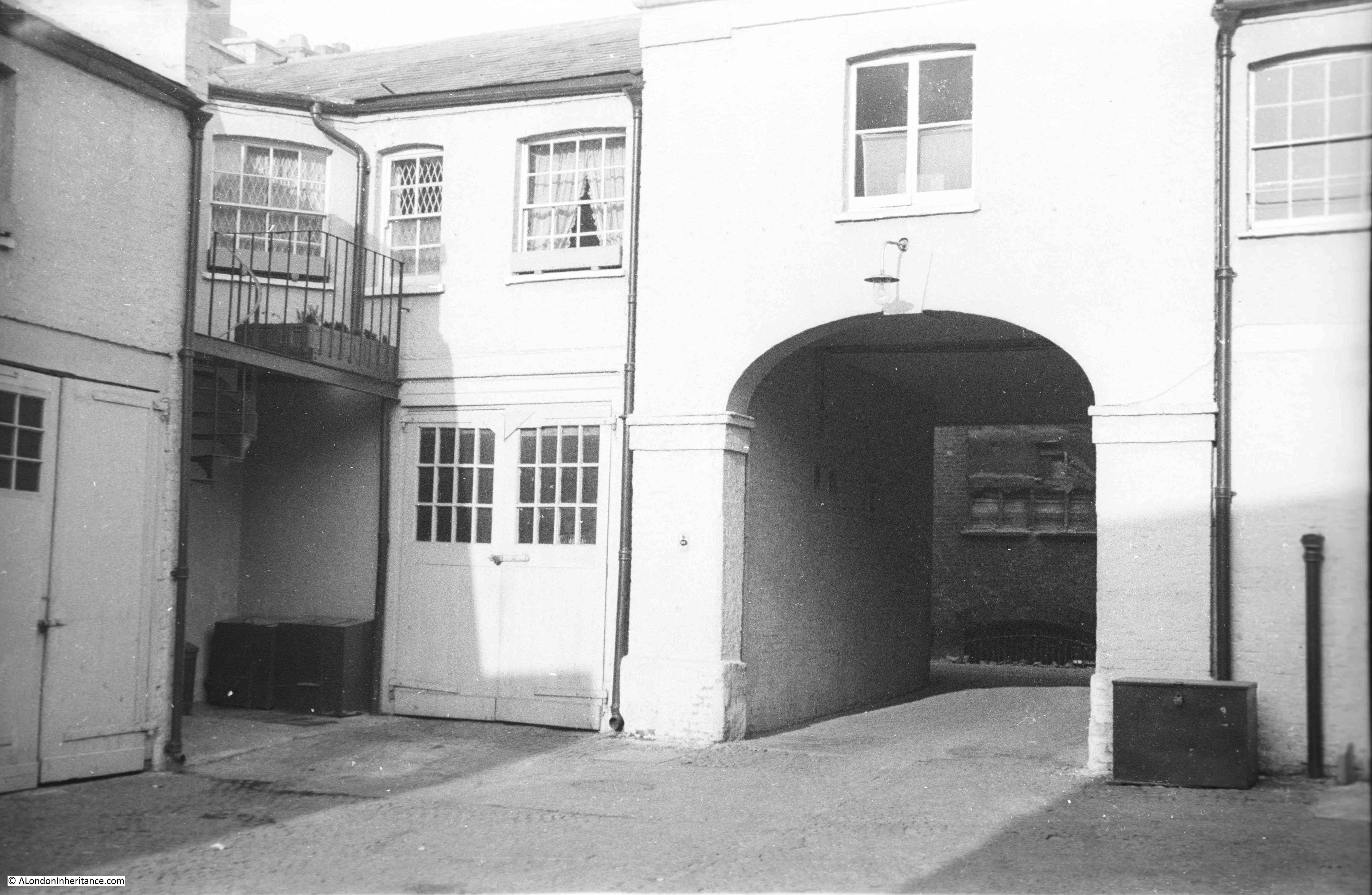
The Pillars of Hercules – Greek Street
I have included the Pillars of Hercules in Greek Street, although despite the pub sign hanging from the front of the building, the traditional Pillars of Hercules closed in 2018.
The name comes from the promontories on either side of the straights of Gibraltar, and which form the entrance to the Mediterranean. The name is of some antiquity and was used by Pliny the Elder in the first century AD, and is almost certainly much older.
The pub sign shows Hercules with his back to one pillar, and his hands on the front of a second pillar. The relevance of the entry to the Mediterranean is that it would have once been the limit of the known world, and was the furthest point to which Hercules ventured, or that Hercules is holding back, or narrowing the entrance, or the pillars are holding up the sky – there are a number of interpretations.
There has been a pub on the site since 1733, although I cannot find confirmation that the name has remained the same since that date, although it has been in use for a long time.
The pub closed in 2018 and reopened as Bar Hercules, and is now a Cocktail bar within the Simmonds chain.
The present building is relatively recent, having been built around 1910, and when open, the pub had a lovely sign running above the pub and over the passage which is the entrance to Manette Street, as shown in this photo from 2008:
Today, the front of the old pub looks very sad following the lost of the pub name:
I do not know why the original pub closed, from memory, it always seemed to be busy, and on summer evenings, the pavement outside would be crowded with drinkers.
A sad loss.
The Green Man – Berwick Street
As can be seen in the above photo, the Green Man occupies two buildings. They both have individual Grade II listings, and the Green Man did not always occupy both buildings.
The building on the right is the original Green Man, with the listing stating that it is a Public House, early 19th century.
For the building on the left, the listing states “Former terrace house. Front of same build as early C19 adjoining No. 57 but probably refronting of earlier C18 fabric.” so it was originally a house, and seems to have an older internal fabric than the original Green Man building.
The listing for the pub states early 19th century, and the first record of the pub that I can find is from 1822, when, in a court case a prisoner was being tried for a number of offences, including stealing “a new pair of linen sheets” from the Green Man after he had stayed in one of the pub’s rooms.
The Green Man was one of the pubs in London that held “Repeal Meetings”. These were meeting organised by the Repeal Association which was an Irish movement founded by Daniel O;Connell in 1830 to campaign for the repeal of the 1800 Acts of Union between Great Britain and Ireland.
Other London pubs holding repeal meetings during the same week (15th January 1842) included the Union Arms on Holborn Hill and Buckley’s Rooms in Old Boswell Court.
The campaign seems to have been for an independent Ireland, but still within the British Empire – “the same right of legislative independence as England, always subject to the constitutional supremacy of the British Crown” as described in one of the speeches during the Repeal meeting in the Green Man.
Many London pubs were places where campaigns such as the Repeal Association would meet, and they would also be the meeting places of various clubs and associations, and one club meeting in the Green Man was, perhaps rather unusual for central Soho, as the Green Man was the meeting place in the 1870s for the United Marlborough Brothers – one of the very many London Angling Clubs that met in lots of pubs across the wider city.
I cannot find when the Green Man took over the house next door to become the double fronted pub we see today, however it is a wonderful survivor and as far as I can trace, the Green Man has been the continuous name of the pub since the pub was opened over 200 years ago.
A few more of the many pubs that can still be found across the streets of Soho.
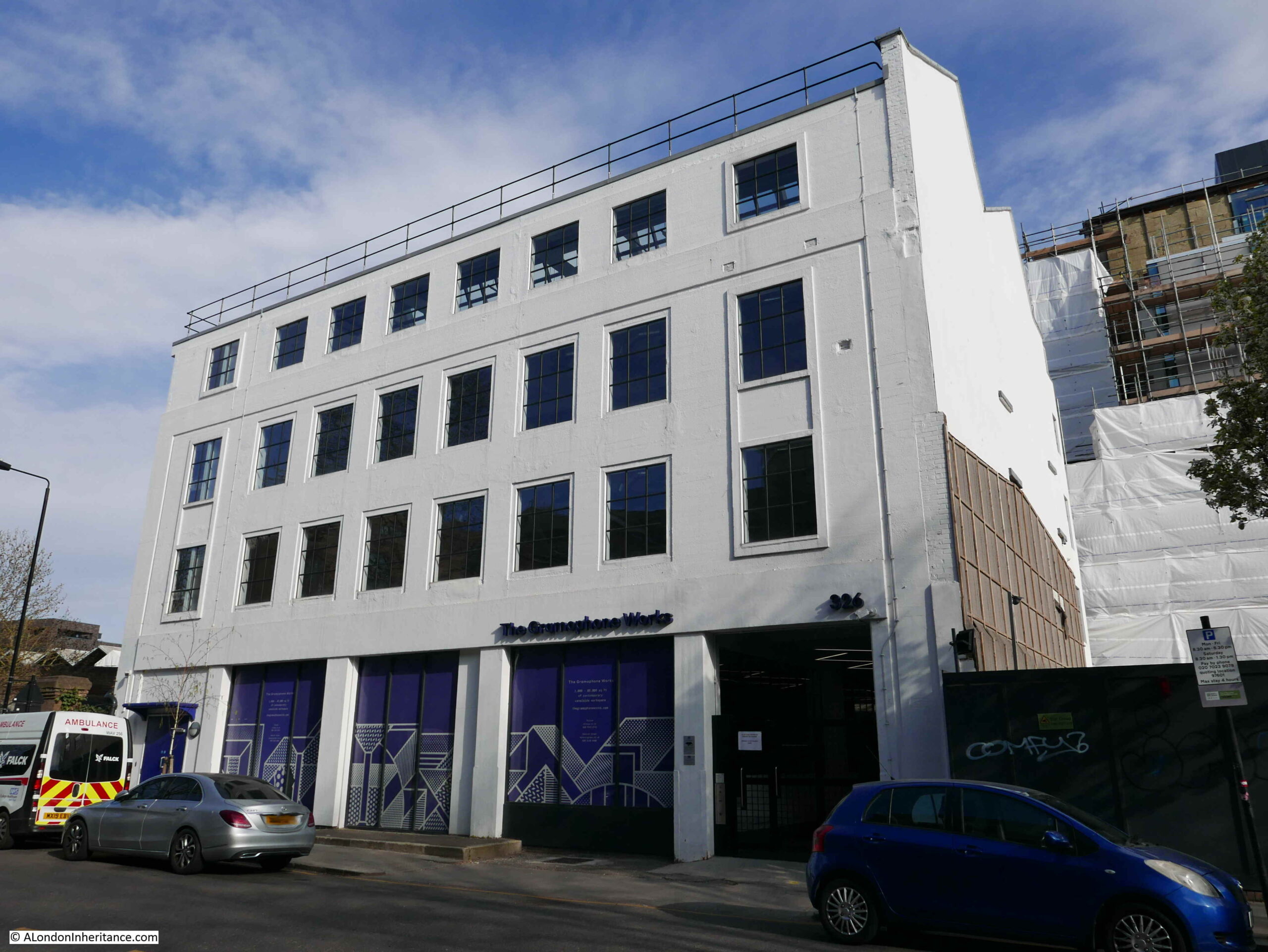
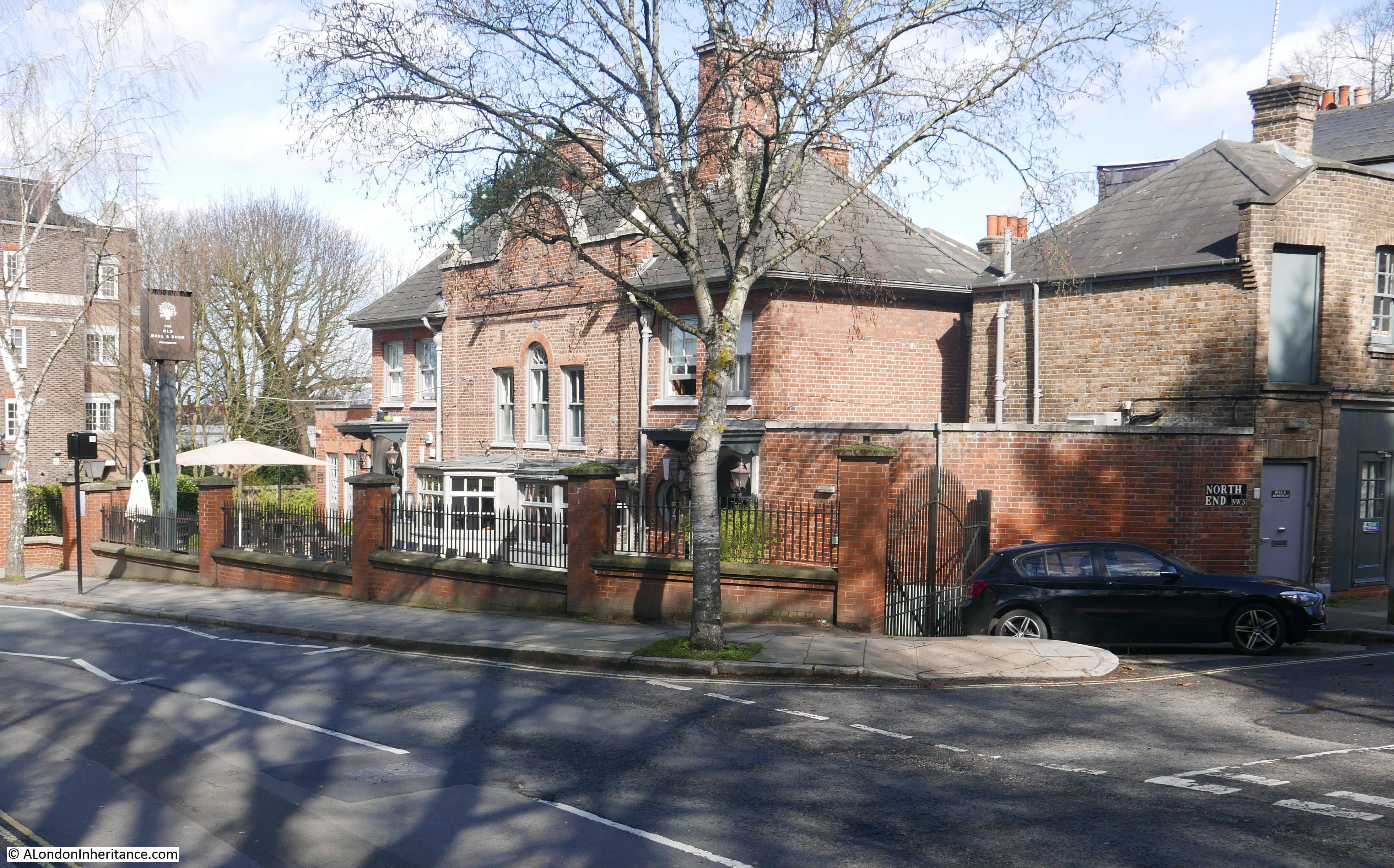
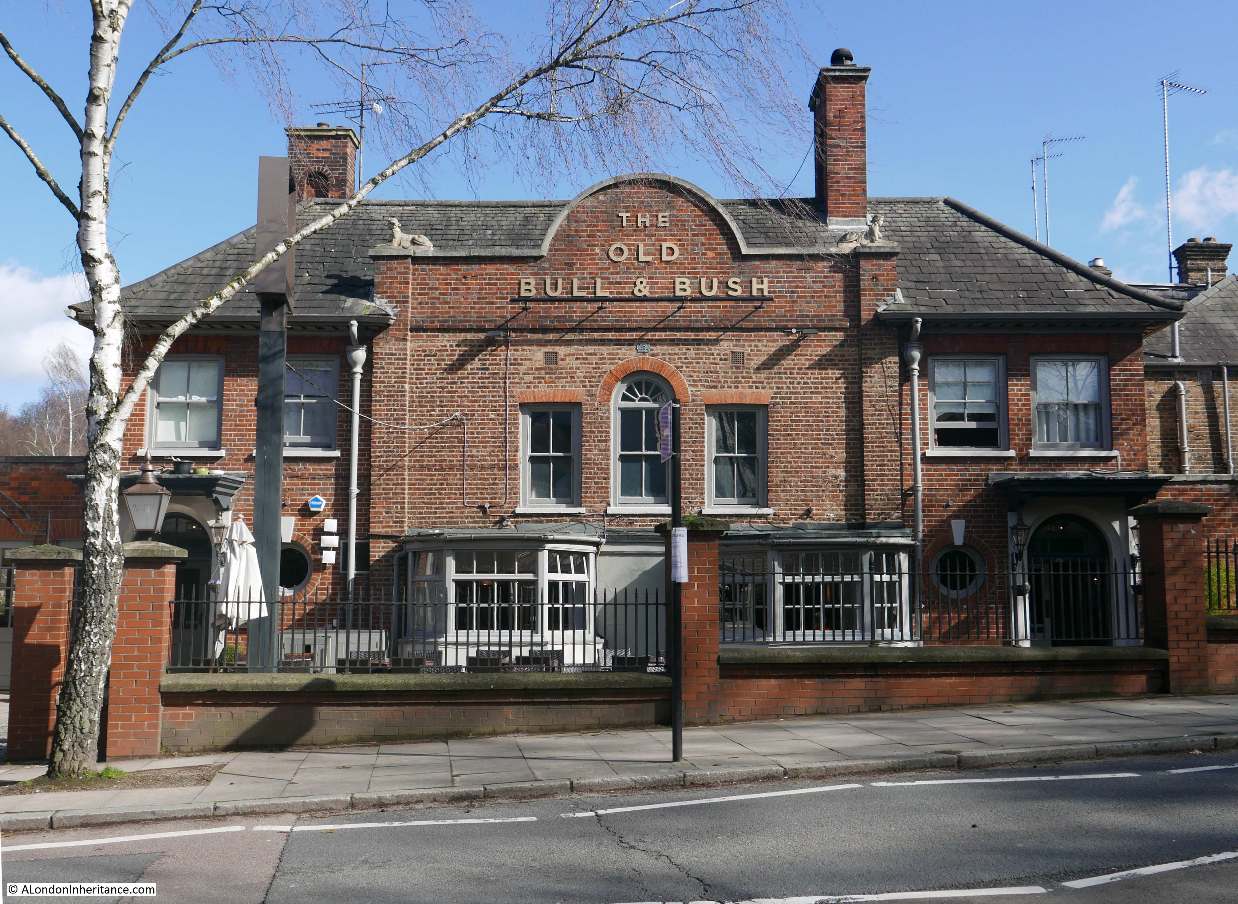
I am back in Soho for this week’s post, continuing my exploration of Soho pubs, including one that claims to be “the West End’s best known pub”, and that “it’s a deeply loved London institution with a rich history”.
The pub with these claims will be later in the post, and is one of many fascinating and individual pubs to be found across part of London which, along with the City, has the highest density of pubs, and where drinking has been embedded in the culture of the place.
Today’s tour starts with:
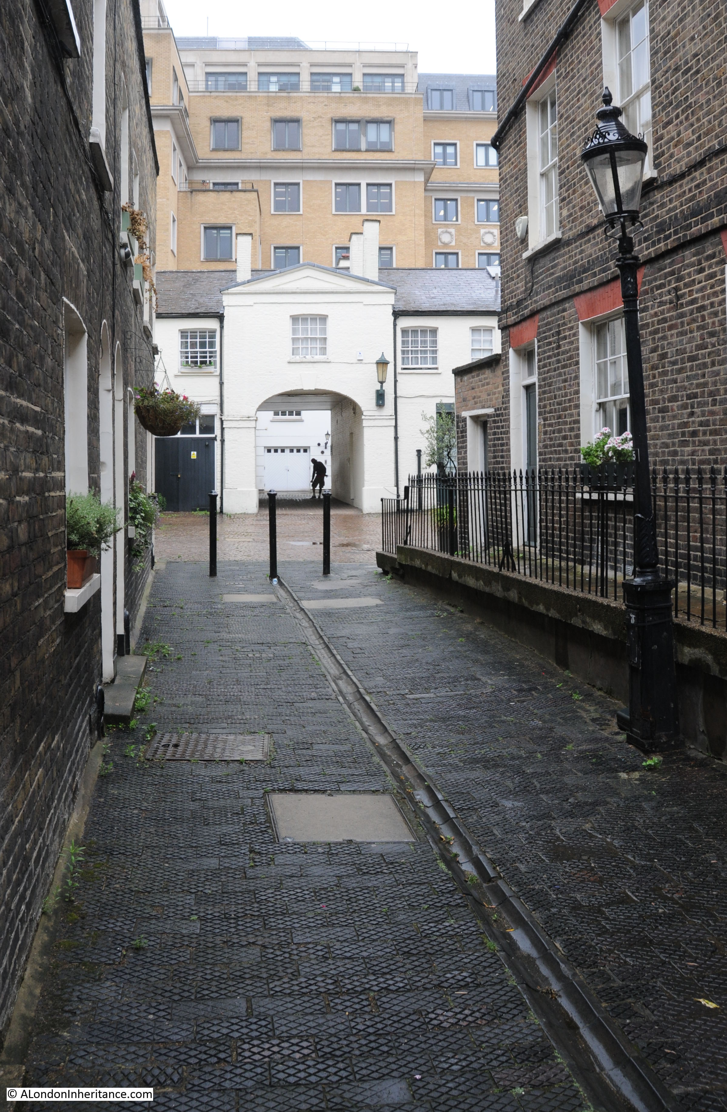
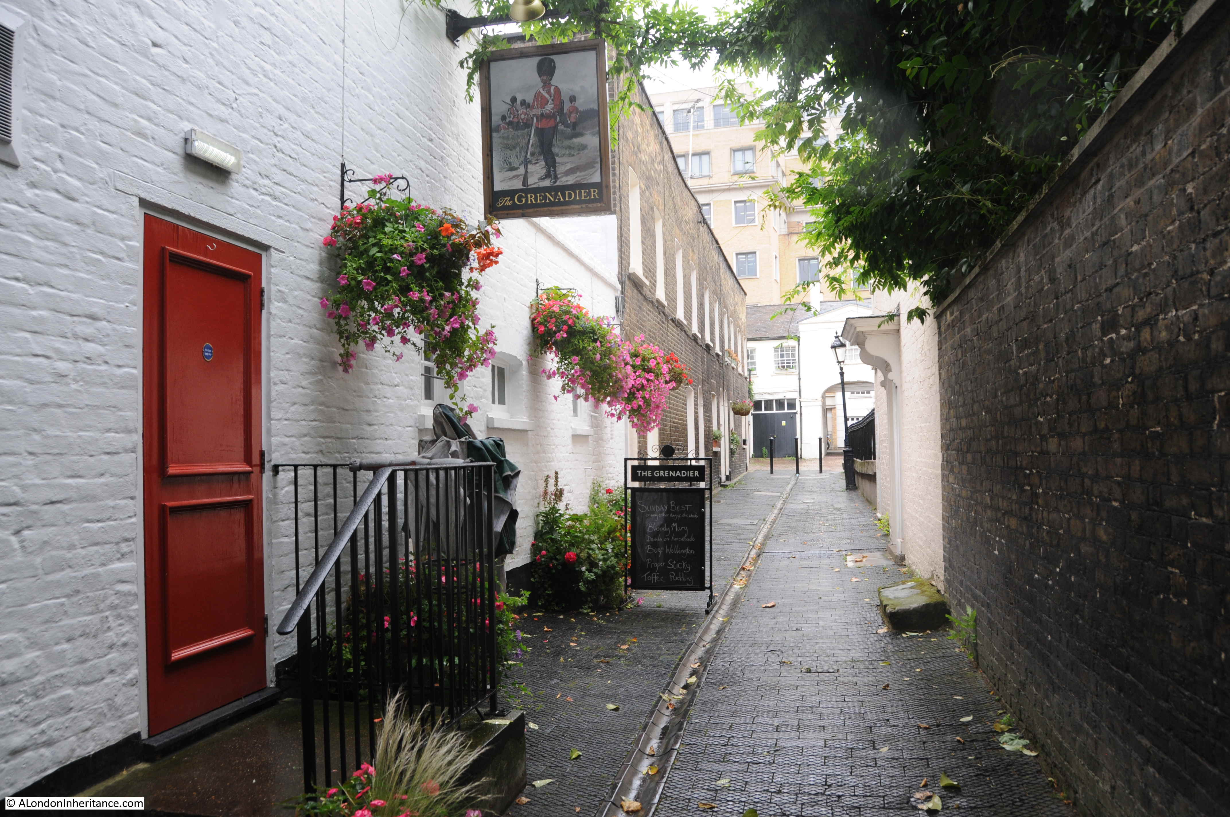
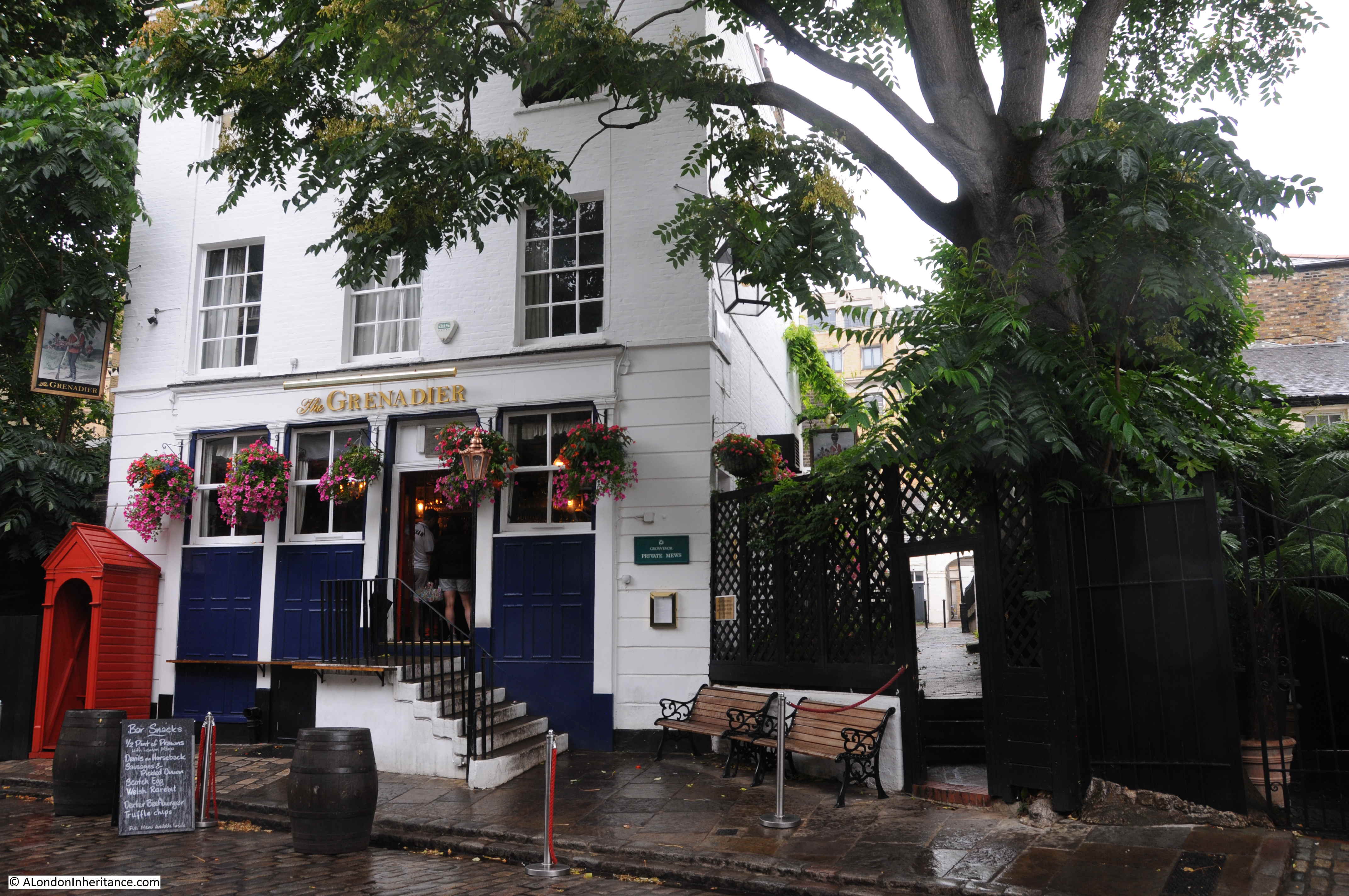
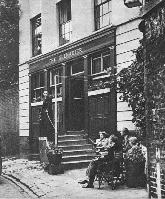
The Crown and Two Chairmen – Dean Street
The Crown and Two Chairmen is one of the more unusual London pub names. The building we see today dates from 1929, however there has been a pub on the site since 1736 when it was called just the Crown.
The story about the change of name to the Crown and Two Chairmen is that two sedan chair men who were taking Queen Anne to have her portrait painted by Sir James Thornhill, who apparently had his studio in the area, would call at the pub for a drink.
One of the places where this story was put forward was an article in the Sporting Life on the 3rd of November 1926 on historic pubs, where the following was written about the Crown and Two Chairmen, as one of the oldest-established hostelries in the West End:
“It is the only inn of the name in London, and is said to derive its title from the fact that the bearers of Queen Anne’s chair were wont to beguile their time there while Her Majesty was sitting for her portrait to Sir James Thornhill, who lived in the house opposite. This house, No. 74, is still standing next door to the Royalty Theatre.
The Crown and Two Chairmen is probably the tavern mentioned by George Augustus Sala as the one in which he first saw Thackeray. The house was kept by one Dick Moreland, supposed to have been the last landlord in London to wear a pigtail and top-boots, and a small club was held upstairs.”
The problem with this story is that Queen Anne died in 1714, twenty two years before the original pub seems to have been built. The change in name was probably to separate the pub from another pub with the same original name, the Crown in Brewer Street.
I cannot find exactly when the pub changed name, the earliest reference I can find is from August 1811, when the landlord of the pub was unwittingly involved with handling a stolen £10 note. In this reference, the pub had the name of Crown and Two Chairmen.
Whether or not the Queen Anne reference is correct, the pub has one of the more unusual names in London.
The Dog and Duck – Bateman Street
So many London pubs are on the corner of two streets. This makes sense as a corner location stands out far more than within a terrace. Potential customers walking along multiple streets can see the pub, however it does cause confusion with the address of a pub. What street should apply?
Taking the Dog and Duck, the longest side of the building, with three upper floor window bays is on Bateman Street, and this is the street used in the address of the pub, however, searching for references to the pub, Frith Street is used just as many times as Bateman Street, and Frith Street has by far the shortest side of the pub, with just a single window bay.
As an example, the building is Grade II listed, and in the Historic England listing, Bateman Street is given as the address of the pub in the header to the entry, however Frith Street is used in the entry detail.
The listing states that that Dog and Duck was built in 1897, and designed by Francis Chambers for the Cannon Brewery. The interior of the pub is “an exceptional survival of a small late Victorian pub interior with tile work, mirrors and high-quality joinery”.
Although the current pub building dates from 1897, it was built on the site of an early 18th century pub with the same name. The earliest reference I can find to the pub dates from the 17th of July, 1752, and reads: “On Tuesday, about Five o’clock in the afternoon, as Lieutenant-Colonel Demarr, of Col. Holmes’s late Regiment of Marines was going along Thrift Street, Soho, he was suddenly taken ill, and went into the Dog and Duck Alehouse, where a Surgeon was sent for to bleed him, but to no purpose, for he expired in a short time.”
The spelling of the street as Thrift Street in the above article must have been an error, as the name Frith Street appears on maps in the 17th century and onwards.
In 2003, newspapers were reporting that the pop star Madonna was a visitor to the Dog and Duck, and that “The ‘Material Girl’ told how she had developed a taste for Landlord at the Dog and Duck in London’s Soho, where it has been sold for about 10 years. her revelation on Jonathan Ross’s BBC talk show has caused a flurry of media activity and now the Campaign for Real Ale are claiming bitter is back in Vogue”.
A nice touch with exterior decoration to the pub is that on the corner of the pub, where there should be a window on the third floor is the following relief showing a dog with a duck in its mouth:
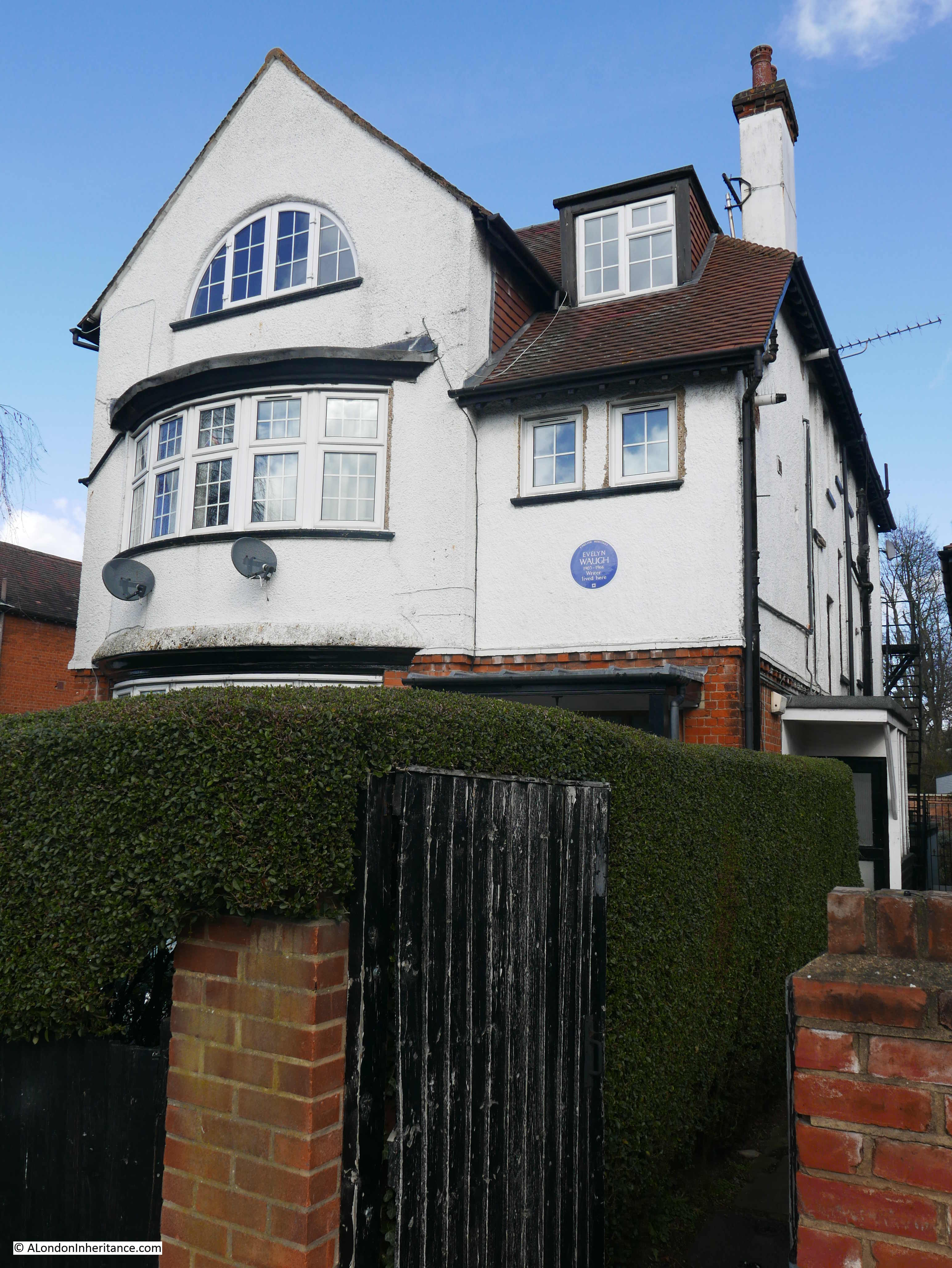
The French House – Dean Street
The pub has had the formal name of the French House for a relatively short period of time, it was originally called the York Minster.
Another example of being careful with sources, Wikipedia states that the “pub was opened by a German national named Christian Schmitt in 1891 and traded as York Minster”, however there are plenty of newspaper reports that mention the pub, going back several decades in the 19th century, with the earliest I could find being from 1837 when a horse trotting challenge was being advertised and that the challenge could be backed at the York Minster, Dean Street, Soho.
The French theme to the pub has been around for some time, in parallel to being called the York Minster.
Although an early landlord was a German national, the pub was for long managed by a Belgian national, one Victor Berlemont, who had a son, Gaston Berlemont who was born in the pub in 1914.
Gaston was a British national, who lived in Soho, and served in the RAF, and became the landlord of the York Minister when his father died in 1951. He continued as landlord until retirement, rather appropriately on Bastille Day in 1989.
The pub was popular with the Free French forces during the Second World War and later Gaston promoted a Gallic image for the pub, and long before the change of name, it became known as “The French”.
There are two films of Gaston’s retirement on the 14th of July 1989 on YouTube. Part 1 is here (if received via email, you will need to go to the post on the website here to view):
And part 2 is here:
As can be seen in the above two films, the name of the pub in 1989 was the French House, and the name change had taken place 5 years earlier in 1984 after the fire at the real York Minster, when apparently donations for the repair of the church in York were being received at the pub in Soho, which Gaston did forward to York (and there is a story that wine destined for the pub in Soho reached the real York Minster in York).
The change in name was really just a formality for the pub due to its decades long association with a French influence. For example, in The Tatler on the 28th of January, 1953, the pub was described as follows: “York Minster, Dean Street, opposite bombed St. Anne’s. Upstairs in the small pub there is excellent, plain French cooking to be had most days. It is lucky if you happen to like one of the plats du jour, for they are one of the best bets. You can have wine by the glass and those who favour the drink can watch absinthe dripping into their glass on the zinc downstairs. There is nothing very French-looking about the York Minster (nothing except the period, to remind you of the Toulouse-Lautrec film), but most of the clientele is Soho-French. So is the patron.”
The French influence continues to this day, with the French flags on the front of the pub, and with the menu at the first floor restaurant.
Admiral Duncan – Old Compton Street
The Admiral Duncan in Old Compton Street, known as Soho’s oldest gay pub, was the scene of a bomb attack in 1999, when it was the third London site attacked by the so called at the time “London Nail Bomber”.
Although no one had died in the previous two attacks, the bomb at the Admiral Duncan killed three,. When the attacker was sent for trial, newspapers summarized the accusations: “A 23 year old engineer accused of murdering three people in London nail bombings was committed for trial yesterday at the Old Bailey. **********, of Cove, Hampshire, is accused of murdering Andrea Dykes, John Light and Nicholas Moore in a bomb blast at the Admiral Duncan pub in Soho, central London, on April 30th. He is also accused of three counts of causing an explosion relating to the bombing at Electric Avenue, Brixton, south London, on April 17th, a bombing in the Brick Lane, east London the following Saturday and at Soho on April 30th.”
He should have been charged with four murders as Andrea Dykes was pregnant.
The choice of bomb locations, where minority and vulnerable people were targets gives some indication of the attacker’s motivations as a neo-Nazi, who used bombs packed with nails, designed to cause maximum harm to anyone in the vicinity of the explosion, and many of the 139 injured in the three attacks had horrific injuries.
He told police that he “wanted to be an infamous murderer who started a race war”.
The above newspaper report included his name, however I have deleted it, as people who do this should not have their names remembered (as was his intention), rather they should be consigned to oblivion. He was given 6 life sentences, and hopefully should never be released, although he is eligible for parole in his seventies.
The Admiral Duncan pub seems to date from the early decades of the 19th century, I suspect it was 1826 as the Admiral Duncan was advertising for staff, for example with the following advert from the Morning Advertiser on Thursday 15th of June, 1826: “WANTED in a Public-House a SERVANT of ALL-WORK. A young Woman of good character may apply at the Admiral Duncan, Old Compton-street, Soho.”
The bomb attacks were the result of an individuals hatred and discrimination of other communities, and the above advert of staff in 1826 ended with another example, as it ended with “No Irish person need apply”.
A couple of month later, the Admiral Duncan was advertising for “a SERVANT of ALL-WORK – A young English WOMAN of good character”.
I do not know if this was specific to the landlord of the Admiral Duncan in 1826, as you do not see this type of discrimination that often in adverts for pub staff in the early 19th century.
The pub is named after Admiral Adam Duncan, who was the Admiral in charge of the Royal Navy fleet that defeated the Dutch fleet in the battle of Camperdown (or Camperduin, the Dutch name of the town on the coast of the Netherlands) off where the battle was fought.
The battle was a significant victory, and is ranked as one of the most important actions in the history of the Royal Navy.
Duncan was made a Viscount and received an annual pension of £3,000 as a reward for his success, and there seems to have been a number of pubs given the name of the Admiral Duncan in the first half of the 19th century.
Comptons – Old Compton Street
Comptons in Old Compton Street is another Soho LBGTQ pub, however the current name is relatively recent.
It started out as the Swiss Hotel a private hotel that seems to have catered for the Swiss community as in 1874 is was advertising for “a young Swiss”, who also speaks English. Whether having Swiss staff was to support a Swiss customer base, or as a novelty for English customers is not clear.
It could be the former as a year earlier in 1873, there was an advert placed by a Swiss person who gave the Swiss Hotel as an address, and who was looking for a position as an indoor servant, and among their abilities were listed as being able to speak French, German and Italian, and a little English. The hotel seems to have been a place for those from Switzerland to stay.
The earliest reference to the Swiss Hotel I can find dates from 1871 when there is a record of the license being transferred from James Dennler to Rodolphe Stauffer.
The Survey of London volumes for Soho entry for the Swiss Hotel opens with “This was built in 1890 to the plans of the architects W. A. Williams and Hopton, who exhibited their design in that year at the Royal Academy.”
The Survey of London does not make any mention of the Swiss Hotel as being in Old Compton Street before 1890, however taking newspapers from the 1870s and 1880s, there are mentions of the Swiss Hotel, and 1890 could be a reference to the build of the current building on the site, rather than the institution of the Swiss Hotel.
The last reference to the name Swiss Hotel I could find is from 1969 when it was the site for a large gathering of West End members of the National Association of Theatrical and Kine Employees union.
By 1972 is was known as the Swiss Tavern, and was the home of the Playroom Theatre Club, which was advertised as “A new lunchtime company, has been formed by Jonathan Burn and Alan West at the Swiss Tavern, 53 Old Compton Street, W.1. The aim is to present original and experimental productions, for which applicants are welcomed whether engaged in the evenings or not. Workshop exercises with emphasis not only on the group but on individual expression will be part of the activities. A number of directors, writers, actors designers and technical personnel are already collaborating but a total number of from ten to fourteen is needed.”
One of the productions put on at the Playroom Theatre Club in 1973 attracted much publicity, including the following from the “Entertainment” section of the Marylebone Mercury (excuse the language):
“On the fringe of respectability – THEATRE on the cheap is alive and doing all right in the pubs of Soho. They call it fringe theatre and it certainly is in every way – on the borderline of respectability, like Soho itself, and of bankcrupty.
The Playroom Theatre Club, above the Swiss Tavern pub in Old Compton Street has been going a year almost with productions like ‘Areatha in the Ice Palace’ and ‘Wankers’.
The Swiss Tavern is opposite a sex-movie club, next door to a strip club. No wonder one of the biggest hits by Playroom was ‘Wankers’, which had to be retained for an extra week.
People who think ‘ pornography’ must be awfully disappointed, said producer Judith Wills from Missouri.”
Later in the article, the producers complained that “So far, despite pressure, the Arts Council has refused to help this sort of fringe theatre”, and that this refusal could have been due to being over a pub. There was a number of other fringe theatre groups operating in pubs across Soho.
The Playroom Theatre Group does not seem to have lasted beyond the end of 1973, however the Swiss Tavern continued to be one of the Soho pubs frequented by those in the acting profession.
The name Swiss Tavern disappeared in the 1980s, and by the end of the decade it was known as Compton’s, and in the 1990s, its current identity was well established, as this report from the Scotsman on the 13th of June 1996, illustrates:
“SORRY, but there only is one game in town – England v Scotland on Saturday. It is understood that much of London pubs, clubs and other places of entertainment, plans to close down in spite of Scottish fans having one of the best reputations in world football.
But at least one pub will be open. Compton’s in Old Compton Street run by Stevie and George from Glasgow, will welcome Scots. One thing to remember; it is reputed to be Soho’s best gay pub.”
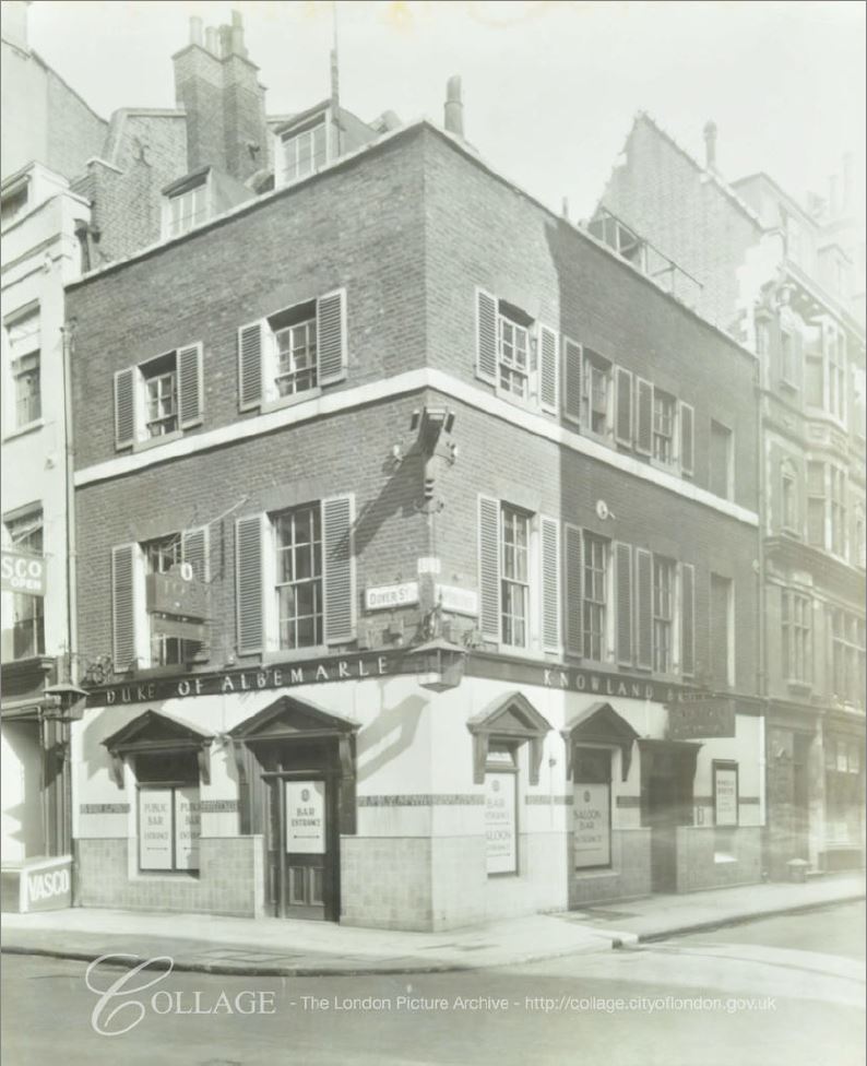
The Golden Lion – Dean Street
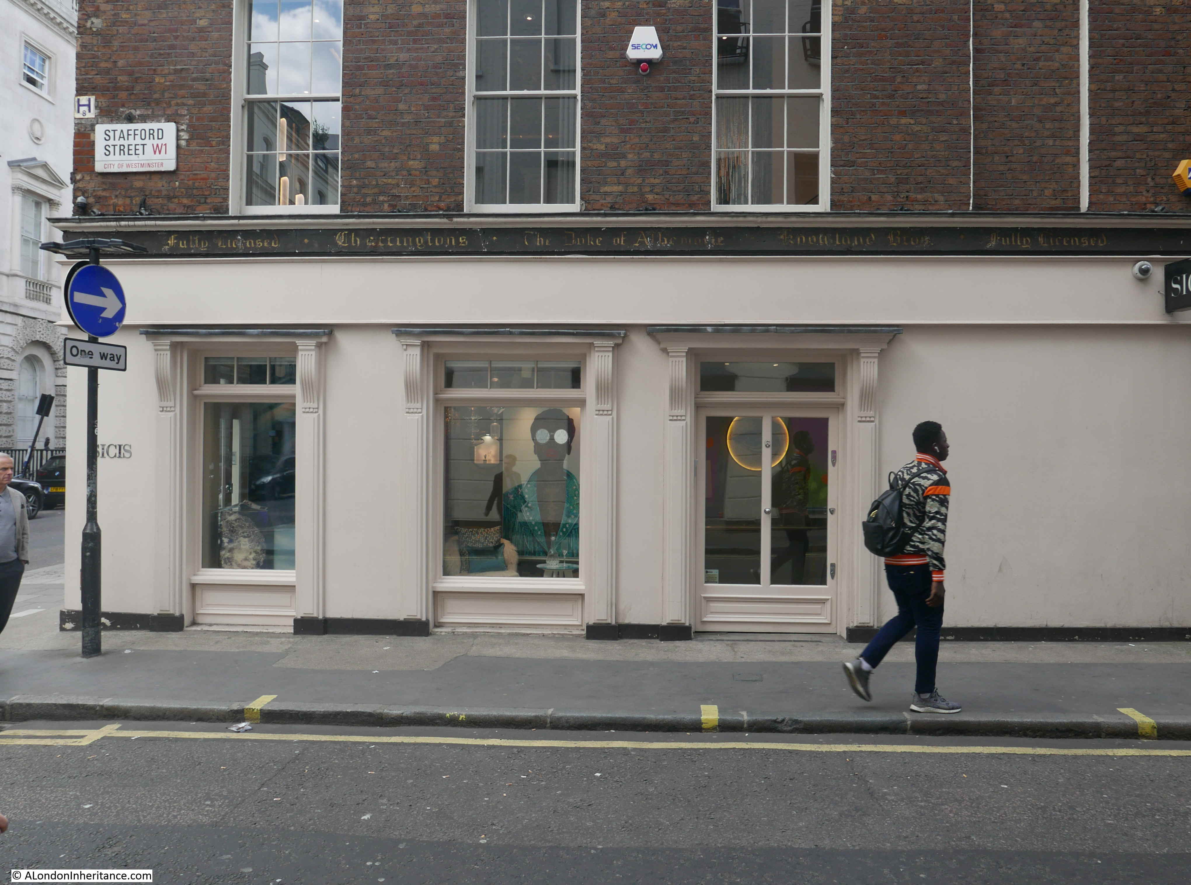
The Survey of London records that the Golden Lion existed in 1728, so this is an old pub, although the building on the site today is a later version of the pub, having been built at the end of the 1920s for the brewer William Younger.
The current version of the Golden Lion does retain a number of features saved from the earlier building, including this rather impressive sun dial from the time before the rebuild when it was known as Ye Golden Lion:
The journalist, author, TV presenter, and Soho drinker, Daniel Farson wrote the book “Soho in the Fifties” about his time in Soho during the decade, the people he met, the pubs restaurants etc. The book contains many of Farson’s photos of life around Soho at the time, and it is a brilliant book for a snapshot of Soho, a Soho that for the most part, has been lost.
He wrote about the Golden lion under the title “The Queer Pubs”:
“In Soho there were two ‘queer pubs’ as they were called then, the Fitzroy off Charlotte Street to the north, and the Golden Lion in Dean Street to the south. Though the Lion was a few doors away from the French, the two pubs had so little in common that they might have been in separate towns. Married couples wandered into the Lion by mistake and left swiftly when they discovered they were surrounded by strange men, or remained, delighted by their chance discovery, but Gaston (at the French) did not encourage stragglers who crossed the frontier for a change of scene, and one of his quizzical stares sufficed to scare them off again. Only a few customers were regulars of both.”
The Golden Lion later achieved some notoriety as the serial killer Dennis Nilsen picked up at least one of his victims at the pub.
The Coach & Horses – Greek Street
On the sign on the corner of the pub, the Coach & Horses claims that it is “the West End’s best known pub”, and on the pub’s website, that “it’s a deeply loved London institution with a rich history”, but fails to put any of this history on the pub’s website.
The claims seem to stem from one man, Norman Balon, the Landlord for an incredible length of time from 1943 to 2006, when he lived up to his self proclaimed reputation as being the “rudest landlord in London”.
Typical of the many accounts of Norman Balon’s last day at the Coach and Horses is the following:
“The strangely coveted title of London’s Rudest Landlord is now vacant, as its long-time holder, Norman Balon of the Coach and Horses, Soho, tucks the sale price of the pub into his locally made suit and takes the Underground home to his home in Golders Green.
Mr. Balon, 79, has told more people to drink up and leave than Jeffrey Bernard drank large vodka-ice-and-sodas at his bar side during the decades he wrote Low Life, his celebrated Spectator column.
Last week the pub overflowed like a badly pulled pint with well-wishers. Richard Ingrams, founder of satirical magazine Private Eye made a two-sentence speech: ‘the only man grumpier than me. I salute you’.
Writer Beryl Bainbridge cheered, Spencer Bright, biographer of both Boy George and Norman Balon, looked sad.
For this is the pub behind Michael Heath’s extraordinary cartoon strip ‘The Regulars’ in Private Eye, which once had one Regular saying to another ‘I’m sorry I was rude last night. You see, I was sober’.
At the farewell bash, Heath remarked ‘I don’t remember Norman being rude. in fact, i don’t remember anything from those years’.
By classic Soho standards of stiletto rudeness, Norman Balon was a measured man. Tourists asking for sandwiches might, though, be puzzled to be told to leave and not come back. It was a defense mechanism against bores. The Coach, as everyone called it, was a pub for talking, since Mr. Balon would tolerate no jukebox, among other things.”
The Coach and Horses featured in the play, “Jeffrey Bernard is Unwell”, by Keith Waterhouse, which opened in London at the Apollo Theatre in Shaftesbury Lane in October 1989, with Peter O’Toole playing the lead character of Jeffrey Bernard, with a small supporting cast.
Jeffrey Bernard was a journalist who wrote for Private Eye and Sporting Life, and for the Spectator under the name of “Low Life”, where he wrote about his life in Soho and in the Coach and Horses where he was very much a regular.
The magazine Private Eye held their lunches at the pub for 25 years.
Norman Balon’s biography was ghost written by Spencer Bright and went by the title of “You’re Barred, You Bastards: The Memoirs of a Soho Publican”.
There is a 1987 BBC Arena documentary about Jeffrey Bernard which includes film within the Coach & Horses:
And another documentary on Jeffrey Bernard – Reach for the Ground, which includes some film of Soho as it was:
The Coach and Horses is Grade II listed, both the pub building, and as part of a block of adjoinging buildings. It is listed for the exterior architecure and for surviving internal features.
The first record of a license for the Coach and Horses dates back to 1724. The current building dates from around 1840, and the pub was remodeled and extended in 1889, with the interior bar from 1930 when the pub was taken over by Taylor, Walker & Company.
It is a wonderful pub, and a reminder of a lost Soho.
The Three Greyhounds – Greek Street
The Three Greyhounds claims that the name comes from the greyhounds that roamed the area that became Soho, when it was open field.
The pub appears to date back to 1837, when Soho was a densely built and populated area of London, and greyhounds roaming the fields would have been a couple of centuries before. The mock Tudor styling of the pub probably intends to give its appearance some age.
I cannot find too much of a history to the Three Greyhounds, apart from it being a typical Soho pub which attracted its fair share of writers, musicians, those active in the theatre industry etc. All who were once part of the drinking culture of Soho.
The journalist, author, TV presenter, and Soho drinker, Daniel Farson quoted earlier in the section on the Golden Lion, included in his book a summary of “A Soho Type of Person” and which encapsulates how drinking was such an important part of the culture of Soho:
A Soho Type of Person:
The drinkers in the French symbolised Soho in 1951.
What makes a Soho type of person? You need a Bohemian streak to find the lure irresistible. You would never contemplate going out for ‘just the one’ unless it was the one day. Soho people rarely use ‘drink’ in the singular – lets meet for a drink, or we’ll discuss it over a drink – for they know that that much singularity is absurd. Yet they take offence if someone asks them if they want ‘another’ for the semblance of self-discipline is vital.
An alcoholic hates drink; the Soho person loves it. This is why there are so few alcoholics in Soho though plenty of drunks.
Soho people do not tell ‘jokes’ and avoid the eyes of those who do. They relish true stories, especially of their friends’ disasters. equally they enjoy celebrating a friend’s success….when the friend is paying. The good luck might rub off.
A Soho person is someone:
who is not afraid to cry in public;
who rarely travels by public transport, preferring the privacy of taxis;
who regards taxes of the other sort, and all brown envelopes with little windows, as an unwarrantable intrusion;
who cashes cheques anywhere, except the bank;
who seldom knows the date;
who will miss a dinner appointment if he is enjoying himself;
who has been barred from at least one pub, club or restaurant;
whose life staggers from the gutter to the Ritz and maybe back again.
Pubs have long been an important part of life in Soho, and is one of the reasons why so many pubs remain. I will continue exploring these wonderful institutions in part 3 of my tour of Soho pubs.
There are two areas of London that probably have the highest concentration of pubs in the whole city – the City of London and Soho.
Much of the wider London area once had a far higher number of pubs than now. You only have to look at old OS maps from the end of the 19th century to see just how many there were in, for example, east London, with some areas having a pub almost on every street corner.
Whilst many have closed, a high number have survived in the City of London due to the number of City workers and the type of business in the City being conducive to socialising and meeting in pubs. Whilst the traditional liquid lunch has mainly become a thing of the past, one only has to walk through the City on a summer’s afternoon to see plenty of busy pubs, with drinkers spilling out onto the pavement.
The other area of London with a high density of pubs is Soho.
As with the City of London, Soho has always been a distinctive area with historically many aspects of the place being conducive to pub culture. There continue to be a high number of pubs in Soho to this day. Generally always busy with locals, workers, visitors and tourists, and four years after searching for City pubs, I thought I would explore Soho pubs, and today is the first of three posts over the coming couple of months detailing the results.
Every Soho pub has a back story. Some extensive, some quite humble, but there is something to discover for each pub, the majority of which have been there, and often rebuilt, since the 18th century.
So today is the first post on Soho pubs, and I will start with a visit to:
The Devonshire – Denman Street
There are plenty of pubs closing and it is not often that a pub reopens, but that it what has happened with the Devonshire.
Originally the Devonshire Arms, the pub dates back to 1793, and for the following 219 years it was a typical Soho local pub.
The Devonshire Arms closed in 2012 and soon after became a Jamie’s Italian restaurant.
The building’s use as a restaurant ended a couple of years ago, and new owners completely refurbished the building to the standard of a traditional pub on the ground floor, and restaurant seating on the upper floors, and reopened as the Devonshire in 2023.
Judging by how many people are using the pub every time I have been in, or walked past, it appears to be very successful, and apparently has the reputation of selling the most pints of Guinness of any pub in London.
Looking back at the history of the pub, the only thing I could find were recurring stories of typical London low level crime, however there was one report, dating from the 18th of August, 1894 which highlighted some of the challenges of policing 19th century London:
“On Saturday evening a desperate affray took place outside the Devonshire Arms public-house, Denman-street. it appears that a constable was called to eject some men and women from the public-house named. When they got outside the mob made a rush at the policeman, who was thrown to the ground. He got up, however, and blew his whistle, and several other constables quickly arrived. A desperate fight then took place, in the course of which one of the policemen was stabbed in the back by one of the women with a large hair pin. Other constables then arrived, and after much trouble four men and two women were taken to Vine-street station. Several hundred people witnessed the conflict.”
Hopefully the Devonshire now has a more peaceful, and long future as a restored Soho pub.
The Queens Head – Denman Street
The Queens Head in Denman Street is a lovely traditional, independent London pub.
My use of the word traditional is for a pub which has a bar, typically all wood, with hand pumps. Shelves behind the bar full of bottles of spirits. A large bar area with a mix of seating and standing, with wooden seats and tables. The Queens Head is independent in that it is not tied to a specific brewery, and therefore able to sell a range of beers and spirits.
The Queens Head claims to date back to 1736. I cannot find any evidence that would either confirm or contradict the date.
There are plenty of newspaper references to the Queens Head, petty crime, the societies who used the pub as their meeting place etc. but my favourite was an article that shows that back in 1874 you could get a large fine or a prison sentence for lying on your CV.
John Holder,a 24 year old barman was taken to court accused of fraud. He had applied for a job as a barmen at the Nightingale Pub in St. John’s Wood.
He said to his prospective new employer that he had worked at the Queens Head in Denman Street but had left after a change of ownership, and that Mr. Cardwell, his previous employer at the Queens Head would give him a reference.
He gave an address for Mr. Cardwell, and his prospective employer went to the address to confirm his references, however his was told that no one knew Mr. Cardwell, and after talking to the Queens Head, it was confirmed that John Holder had not worked at the pub.
In mitigation, poor John Holder told the court that he had been out of work for some time, and could not get a job, and was very sorry for what he had done.
Despite this, he was convicted of fraud and he had to either pay the full penalty of £20 and 10 shillings of costs, or be imprisoned in the House of Correction for three months.
Given his lack of work, I suspect he ended up in the House of Correction for three months, a penalty which seems very harsh for someone who appears to have just been desperate to get a job.
The Crown – Brewer Street
The Crown in Brewer Street, at the corner with Lower James Street.
The Crown is one of the many Soho pubs that has some interesting decoration. Facing Brewer Street, the pub has two upper floors, with a row of four windows along each floor, however along the narrower side of the building, the second floor has a large semi-circle of decoration with the name of the Crown Tavern displayed.
There is some interesting history covering the location of the pub on a panel on the ground floor:
The panel states that the Crown sits on the site of one of the most well known concert halls of the 18th century, the Hickford Rooms.
I found an article about the Hickford Rooms in an issue of the Musical Times, titled “A Forgotten Concert Room”. The following is from the first paragraph of the article, and I will give you the date of the article after this extract:
“Modern London is becoming a new Americanised city, and all its old and peculiarly English characteristics are fast becoming improved out of existence. If anyone who left it during the sixties of the last century return to visit it today, he will imagine himself to be in some foreign town, and for the most part fail to recognise the London he knew so intimately of old.”
That was the opening to the article, published in the Musical Times on the 1st of September 1906, and illustrates what is a theme of the blog, that London has undergone almost continuous change for the entire period there has been people living in what we now call London.
The introduction also follows up on last week’s blog, that the 19th century was one of the periods when there was a high degree of change that set the city on course for the following century.
The article provides the following introduction to Hickford’s Room:
“The long-forgotten old concert-room in Brewer Street has fortunately escaped demolition, and it recalls a chapter of London’s musical history little noticed by the general reader. The building now forms part of the premises of the Club Francais, but for thirty-five years during the middle of the 18th century, it was a much frequented and fashionable resort, and was known by the name of Hickford’s Room.
John Hickford, the proprietor, began life as a dancing-master in the latter part of Queen Anne’s reign, and originally had a dancing school in James Street, Haymarket. There was at that time only one other room in the West-end large enough for concerts of any pretensions, and as that was sometimes difficult to secure, and its proprietor was not a particularly agreeable man, certain well-known artists began to make use of Mr. Hickford’s great dancing room wherein to give their concerts.”
The school mentioned above was in Haymarket, but became so successful that Hickford then moved to the site in Brewer Street, where it was assumed the new hall was designed specifically for Hickford.
The front door of the new hall opened into a square hall, which gave access to the concert room which was at the back of the building, and there was also a staircase which gave access to a small gallery.
The concert room was fifty feet long and thirty feet wide, and the ceiling was coved, and there were moldings, cornices and other decorations, that were in an “elegant style that the brothers Adam improved upon”.
The article mentions a large number of artists who performed at Hickford’s Room, and has the following to say about Mozart playing in Brewer Street:
“Two other shadows, brother and sister, play the harpsichord. The boy is eight years old, the girl thirteen, a demure, motherly child, her hair crowned by a mop-cap. The boy’s playing is phenomenal, and he bids fair to rival Mr. Handel in composition. But the scanty audience is not interested, it cares no longer for these two children who only a year ago were the spoiled darlings of the whole town. The little boy fulfilled in manhood the brilliant promise of his youth, and London should be proud that it still possesses a room once distinguished by the performance of Wolfgang Amadeus Mozart.”
Hickford’s Hall soon faced competition from other halls in London, along with changing fashions as in the later part of the 18th century, interest changed from small musical recitals to orchestral performances, which Hickford’s Hall was not large enough to accommodate.
As well as music, the hall put on other events such as talks and lectures, including in 1761, Thomas Sheridan who gave a “Course of Lectures on Elocution”.
Over the following years, the hall went through a number of changes in owners and use, but survived until 1934 when it was demolished to make way for an annex of the Regent Palace Hotel.
If the hall lasted until 1934, it obviously raises the question of how can the pub be on the site.
As far as I can tell (given the time available for a weekly blog post), the house and main entrance to the hall was on the site of the Crown, and the hall was to the rear of the Crown.
The earliest reference to the crown that I can find are from the years around 1830, so I suspect the house and entrance to the hall were demolished and the Crown was built, with the hall surviving just behind the pub, until demolition in 1934.
Glasshouse Stores – Brewer Street
The Glasshouse Stores is another pub that claims to date back to the 1730s, however the rather unusual current name is not the original, as it had the more traditional pub name of the Coach and Horses.
The last time I can find the original name mentioned is in 1849, and by 1872 the name Glasshouse Stores was in use, as the pub was advertising for an active, single young man, to work as a Potman, and also to wait on the Billiard Room, to wash pewter and also the windows of the pub – so basically anything that was needed.
No idea why the pub changed its name, or the relevance of the new name, however it demonstrates that changing a pub name is not a recent phenomena.
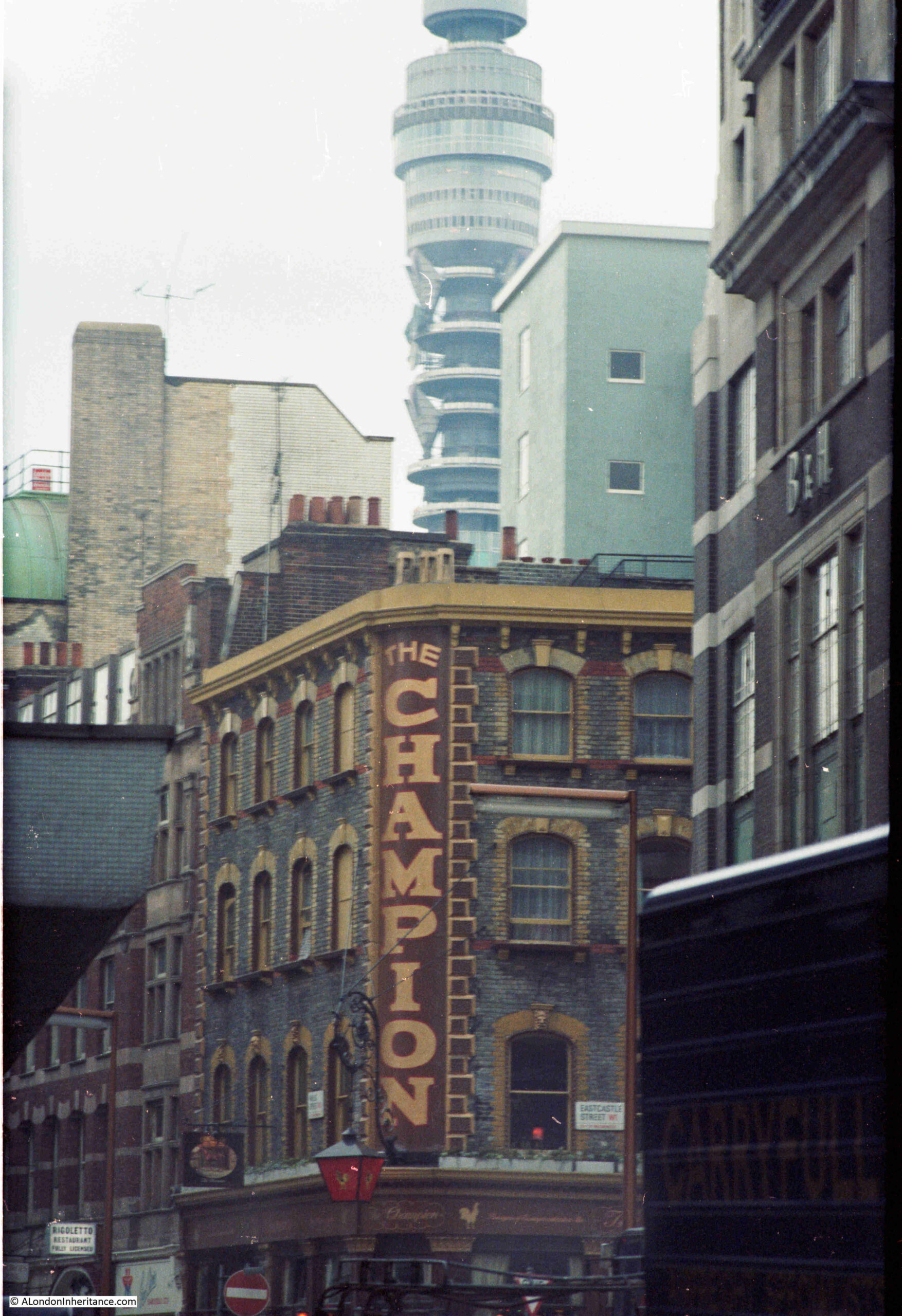
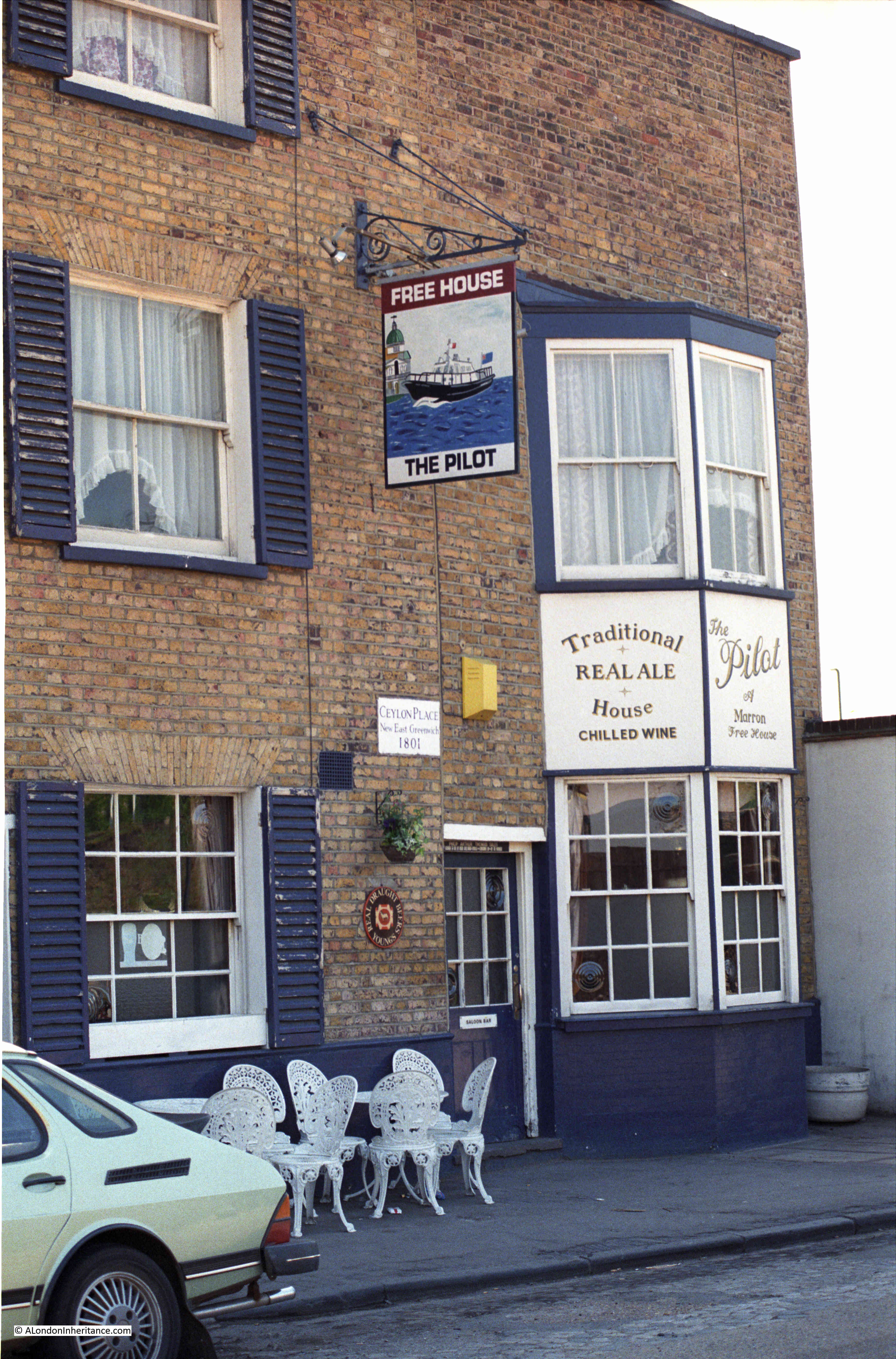
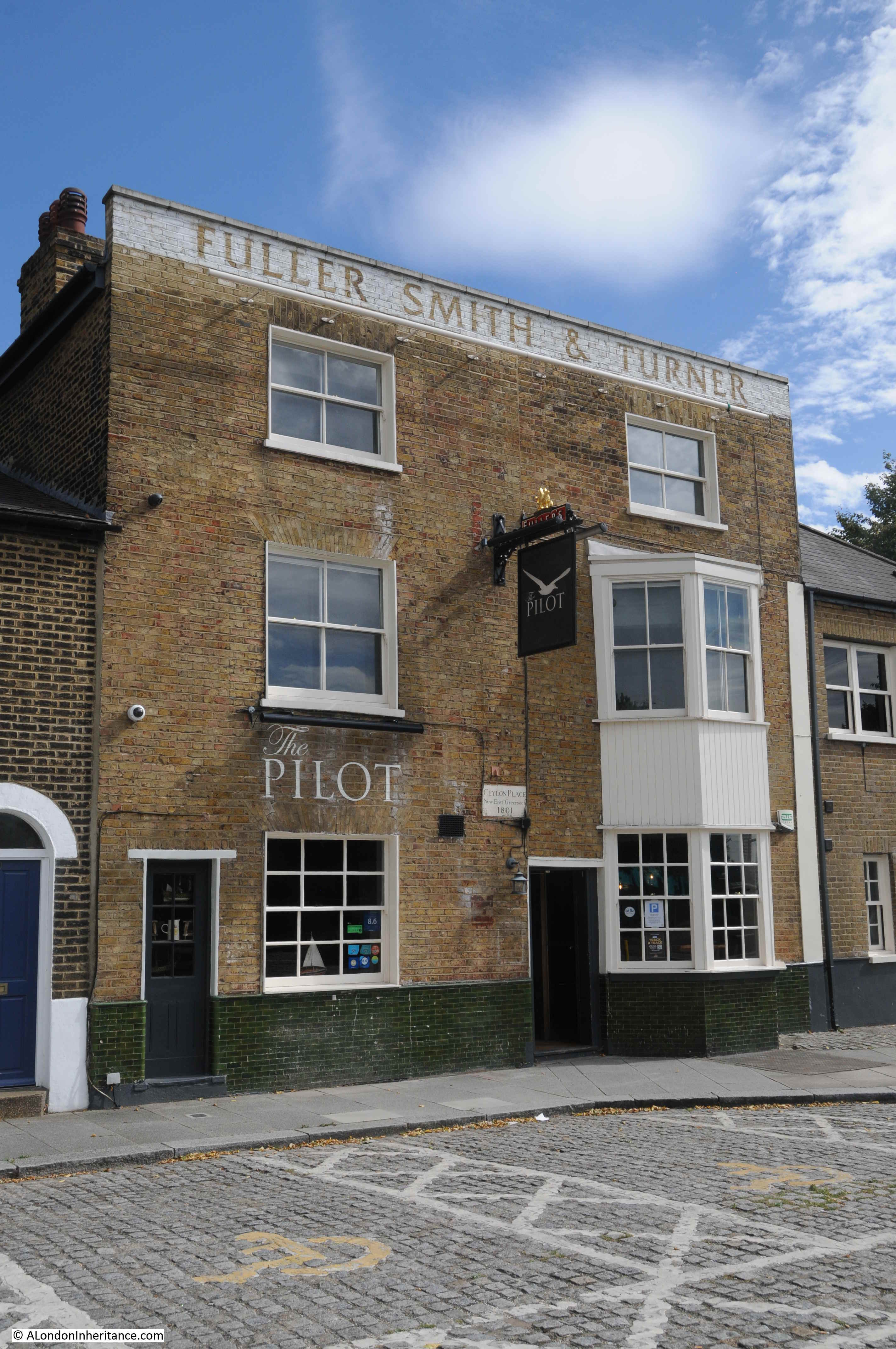
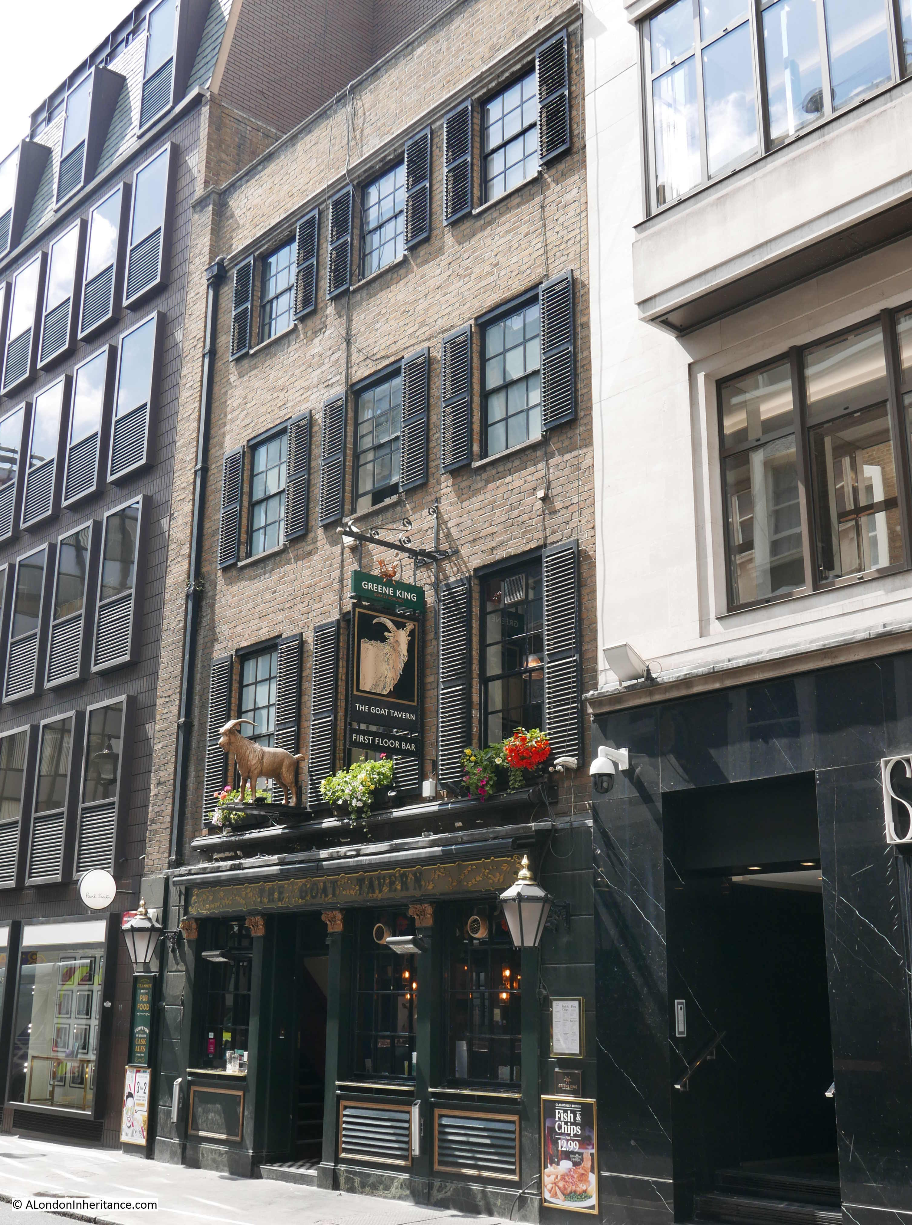
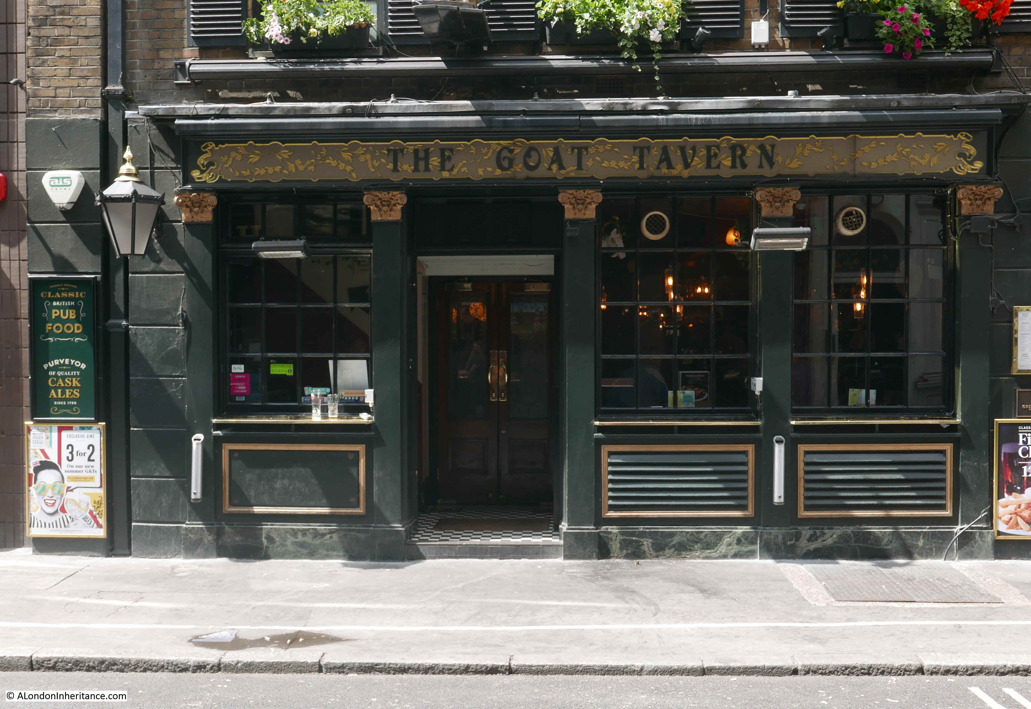
The Sun and 13 Cantons – Great Pulteney Street
The Sun and 13 Cantons must have one of the most unusual pub names in London.
The pub’s website claims that the source of the name is from the Swiss watch-making community that lived and worked in Soho in the late 1800s.
The pub also claims that the name of the pub was originally just “The Sun”, and the 13 Cantons was added in 1882 when the pub reopened after a rebuild, however I am not so sure, and am confident that the pub had its full name of The Sun and 13 Cantons earlier in the 19th century. For example, the following is from the London Morning Advertiser on the 13th of May, 1823:
“Dr. Dell, of the Sun and 13 Cantons, Great Pultney-street, was fined fifteen shillings and costs for the like offence.”
The “like offence” was referring to another fine in the paper where a licensee of a different pub was fined for serving customers after twelve o’clock.
The Englishman (published in London) on the 3rd of June, 1832 had a report about a fire where a couple of people had died, and in the report was stated:
“The inquest was held at the Sun and 13 Cantons, Great Pulteney-street”
To add some mystery, in the London Morning Post on the 22nd of April, 1825, there was an advert for an auction, where Lot 2 was “The Sun and 13 Cantons, Liquor Shop and Public House, on the east side of Castle-street, Leicester Square, adjoining Cecil-court.”
So there are two newspaper reports, one from 1823 and the other form 1832 both referring to the Sun and 13 Cantons being in Great Pultney Street, as it still is today, on the corner with Beak Street, well before the 1882 mentioned on the pub’s website.
The 1825 report is strange as it refers to a pub with the same name, but being in a different, but nearby, location. It is an unusual name for there to be two pubs of the same name, although they were close, so probably had the same association with local Swiss watch makers.
An interesting pub, with a name that recalls some of the people and trades that have made Soho their home.
Old Coffee House – Beak Street
The Old Coffee House is a really good, family run pub, and is well worth a visit for a proper local pub.
The name is strange for a pub, but it does tell of the early history of the site.
The main entrance to the pub today is on Beak Street, and to find the original purpose of the site, we need to look at name changes. The first part of Beak Street was built in 1689 by Thomas Beak, and he gave his name to this first section of the street.
The section of the street where the Old Coffee House is located was developed in 1718, and went by the name of Silver Street. This name was dropped in 1883, when the whole of both Beak and Silver Streets became Beak Street.
A Coffee House was originally on the site of the current pub, and went by the name of the Silver Street Coffee House. I cannot find exactly when the establishment changed from being a coffee house to a pub, but it seems to have been around the 1870s / 1880s, and with a lovely bit of continuity, it kept the Coffee House name as part of the new pub name.
The Old Coffee House appears to have had a number of associations with the theatre, as in the 1920s it was the meeting place on a Sunday morning for members of the Electrical Trades Union Cinema & Theatrical Branch, and in 1948, the Sphere was reporting that the pub had “a very large audition room which has often been used for theatrical rehearsals”. The pub is larger than the pink painted section suggests, as the pub extends further along Marshall Street to the right.
A lovely, traditional Soho pub.
John Snow – Corner of Broadwick Street and Lexington Street
The John Snow pub stands on the corner of Broadwick Street (originally Broad Street) and Lexington Street (originally Cambridge Street). A number of streets in this area of Soho have changed their names since the mid 19th century.
The pub building dates from the 1870s, and was originally called the “Newcastle-upon-Tyne”, The name changed in 1955 to commemorate the centenary of the work in the area of John Snow.
Dr. John Snow, often called the founding father of Epidemiology was known for his work on the transmission of Cholera in London, and he would demonstrate conclusively how this killer of large numbers of Londoners was transmitted. Perhaps hs most well known work was on the location of the source of a Cholera outbreak in 1854 in Broad Street, Soho area.
The Star and Garter in Poland Street is a lovely little pub squashed between two much later and larger buildings.
Researching the pub, it highlights how pubs once served an essential purpose as the meeting place of clubs and societies, and with the Star and Garter it seems to have been the regular meeting place of two groups who were looking to protect the interests of workers and to campaign for improved rights.
in 1834, the Star and Garter was the meeting place for a Society of Journeymen Tailors, and on joining the society, those working in the trade would “meet with constant employment, and the protection from malicious threats of those who are regardless of their own, or the wellbeing of others”.
In 1868 the Star and Garter was the meeting place of the “West End Cabinetmakers’ Branch of the Reform League”. The Reform League was founded in 1865, and campaigned for all adult males to have the vote.
These meetings also identify some of the trades that once occupied Soho, and as well as watchmakers (from the Sun and 13 Cantons), we also now have tailors and cabinet makers.
The meetings in the Star and Garter in 1868 tell of the long struggle for universal suffrage, the right for every adult in the country to have the vote.
In 1831, only 4,500 men in the whole of the country could vote in parliamentary elections. These 4,500 were generally landowners, and there was incredible inconsistencies across the country where the Borough of Dunwich in Suffolk (population 32, and one of the Rotten Boroughs) could elect two MPs, whilst the expanding industrial cities of Birmingham and Manchester did not have any MPs.
Parliament did, very grudgingly, expand the male vote, for example the Second Reform Act of 1867 expanded the vote to men who owned houses or lodgers who paid rent of £10 a year or more.
It would not be until the 1918 Representation of the People Act that the vote was extended to all men, and also gave the vote to women over the age of thirty who owned property, and all women would have to wait until the Equal Franchise Act of 1928, when any women over the age of 21 (the same as men) would get the vote.
When you sit in pubs such as the Star and Garter, having a pint on a summer afternoon, it is fascinating to think of the Londoners who met here to plan how they would be part of a wider campaign for the vote.
Blue Posts – Corner of Broadwick Street and Berwick Street
On the corner of Broadwick Street and Berwick Street is the Blue Posts pub. The current rather attractive building dates from a 1914 rebuild, however there had been a pub on the site since the original development of the area.
The lantern and decoration on the corner of the pub:
As with other Soho pubs, the Blue Posts was frequently used for auditioning those who wanted to get into the entertainment business, and a typical advert (this example from the Stage in 1925) reads:
“Wanted for Mrs Sydney T. Russelle’s Troupes, good all round Lady Dancers. immediate work for the Continent and England. Only first-class ladies need apply between 2 and 4 Thurs and Fridays at the Blue Posts, Berwick Street”
The Blue Posts also has a rather obscure claim to cinematic fame when a model of the pub was destroyed by a brontosaurus in the 1925 film Lost World. The following clip shows the pub just before the brontosaurus crashes in and demolishes the building:
Apparently the animators, who created a rather impressive animated film for the 1920s, drank in the pub they chose to destroy for the film.
There is a Westminster City Council green plaque on the Berwick Street side of the pub, recording that Jessie Matthews, “Musical Comedy Star of Stage and Screen” was born in Berwick Street in 1907. She was not born in the pub, rather in a flat above a butchers shop at 94 Berwick Street, which is almost half way along Berwick Street from the pub.
Perhaps the Council decided that the Blue Posts was a more permanent building, in a more visible location, to display the plaque then the place of her birth.
Duke of Wellington – Wardour Street
The website of the pub describes the pub as “Serving the LGBTQIA+ community for over 20 years, the Duke of Wellington takes pride in being your Soho local” and it is a very busy Soho pub.
It has long had a Wardour Street address, desite the long length of the building being on Winnett Street.
In 1966, the Tatler described the Duke of Wellington as “facing the stage door of the Queen’s Theatre. perhaps the most famous after-theatre pub in Soho. It has been the property of Christ College Hospital since 1723, and Mr. W. Evans has been the tenant since 1931. Old Tudor beams, stag heads and antique vaults. Home-made lunches are enjoyable and plenty of stimulating theatre chat could keep one going until closing time.”
Today, the pub is owned by the Stonegate Group (was known as the Stonegate Pub Company). I cannot find whether this is freehold or leased, but I suspect that Christ College Hospital have sold the site in the past few decades.
The Ship – Wardour Street
The Ship has a Wardour Street address, and is on the corner of Wardour Street and Flaxman Court.
Again, a lovely traditional pub, but a pub which had a more interesting name than just the Ship.
Dating from the late 18th century, and rebuilt in the late 19th century, the pub was originally called “The Ship in Distress”.
I cannot find any reference to the source of the name, whether it referred to a specific ship, or whether it was just an imagined name.
The last mention I can find of the name Ship in Distress is on the 9th of July, 1865, when in a list of license transfers in the Weekly Advertiser, the license for the Ship in Distress was reported as transferring from Charles Humby to Robert Henwood, although in 1859, the pub was referred to as the “New Ship” in a number of newspapers, for example with reports of the results of a Billiard competition between pubs.
The pub may have changed name at the same time as a rebuild, and the use of the old name with the license renewal six years after the name “New Ship” was in use, may just have been an error with records not catching up with name changes.
The name may have changed as the “Ship in Distress” is a rather depressing name, recording either a factual or fictional tragic event. New landlords / owners may have wanted to have a more positive name, and changed to the Ship, which was probably how the pub was called in day to day use.
In recent decades, the Ship was frequently used by many of the musicians who lived, performed, and had business in the area of Wardour Street. The Marquis Club was a short walk from the Ship, and there are various stories about Keith Moon of the Who being banned from the Ship, the Clash drinking in the pub, along with many other musicians.
The George – D’Arblay Street
The George is on the corner of D’Arblay Street and Wardour Street.
To help with dating the building, the year 1897 is displayed on the corner of the building, on the first floor, and on the second floor there is an image of presumably one of the King George’s that the pub is named after.
The Survey of London records that the George has been here since at least 1739, so at around the same time as the street was laid out in 1735. Based on this date, the George could be George II who became monarch in the year 1727.
The George was originally on Portland Street, the original name of the street that became D’Arblay Street in 1909 after Fanny Burney (the novelist, diarist and playwright, who lived from 1752 to 1840), and who lived in Soho, and married French émigré General Alexandre D’Arblay.
I find it strange that to name a street after a woman, you use the surname of her husband. I am always cautious with applying a 21st century view to earlier times, however a quick newspaper search, and the name Fanny Burney was used many, many more times both during and after her life, rather than Madame D’Arblay as she was also known, so rather than D’Arblay Street, perhaps the street should be called Burney Street.
The Hat Tavern – Great Chapel Street
I was in two minds whether to include this establishment, which has a full name of Mr Fogg’s Hat Tavern, and is on the corner of Great Chapel Street and Hollen Street. It is one of a number of taverns and gin establishments across London which go under the Mr. Fogg brand, named after Phileas J. Fogg, the lead character in Jules Verne novel Around the World in Eighty Days.
It is a pub on the ground floor, and a gin club in the basement.
The name Hat Tavern is taken from the building on the opposite side of Hollen Street, which still has the wording “Hat Factory Henry Heath Oxford Street”.
The Henry Heath Hat Factory occupied a large site between Hollen Street and Oxford Street, where hats were manufactured, and sold from the building that faced onto Oxford Street.
The company manufactured hats for a range for uses, from sporting (such as ventilated hunting caps for ladies and gentlemen) to formal (with silk hats).
In 1885, the company was advertising “The Exhibition of ‘RATIONAL DRESS’ – HENRY HEATH of 107, Oxford Street has a sensible improvement in the shape of a soft-banded hat. Everyone knows the painful sensation experienced from the pressure of the usual stiff felt or silk hat; this is quite obviated in the hat manufactured by HENRY HEATH”.
In 1922, Henry Heath celebrated their centenary, and in newspapers announced that their rebuilt showroom in Oxford Street was now open. The factory between Oxford and Hollen Streets employed 200 workers, and their hat making skills led to the following 1922 description of the business in the Pall Mall Gazette:
“Henry Heath has supplied the headgear of each succeeding monarch during the century that has elapsed between George IV and George V, as well as of all the notabilities of each reign. The Prince of Wales, just before his Indian tour, appointed Henry Heath his hatter by Royal Warrant. many foreign monarchs too, have been fitted by Henry Heath, and have appointed him Royal hatter; the King of Spain amongst them.
Such is the International reputation of ‘Ye Hatterie’ as the famous establishment in Oxford-street is known, that visitors from all parts of the globe come to this historic house to be fitted with their headgear while sojourning in London.”
The last mention of Henry Heath hats I could find was in Country Life in 1962 where one of their soft brown hats were been shown as part of an overall outfit. In the 1930s, 40s and 50s they seem to have either moved to, or opened a showroom in New Bond Street, and the number of adverts in the London press declined gradually.
Whether they were still an independent company in the 1960s, I cannot confirm, however it appears that the Henry Heath brand disappeared in the 1960s, most likely the victim of changing fashions and cheaper imports.
The building that once had Henry Heath’s showroom is still to be seen in Oxford Street, and it is an interesting building which I will save for a future post.
That was a bit of a diversion, but it explains why the Hat Tavern has the name.
Before the Hat Tavern opened, the building was the Star pub / coffee shop, before that the Bloemfontein, and originally the George, with the first reference I could find for the George being in the Morning Chronicle in 1817.
“Corner public house. Possibly earlier C18 fabric, refronted c.1800 with c.1900 pub front. Stock brick, slate roof, 3 storeys and dormered mansard. 4 windows wide with 3 window returns to Carlisle Street. c.1900 pilastered pub front to ground floor with angled entrance on corner. Upper floors have recessed sash windows, no glazing bars, under red brick gauged flat arches. Crowning stucco cornice with open cast iron balustrade in front of mansard. Formerly called the “Highlander”. A public house was on the site in 1748. Prominent corner with strong group value.”
The first reference I can find to the Highlander pub is from 1826 when the pub featured in a court report where the defendant was identified as living at the Highlander.
The name Nellie Dean comes from the sentimental song “(You’re My Heart’s Desire, I Love You) Nellie Dean” written by the American composer Henry W. Armstrong in 1905.
The song became the signature song of the music hall star Gertie Gitana, after her brother had heard the song whilst in America.
Gertie Gitana died in 1957, and the following is typical of newspaper reporting of her burial at Wigston Magna, Leicestershire:
“A cold wind blew through the scores of wreaths that had been hung over the railings at the edge of the grave as more than 200 people stood in silent tribute to the gay, sunbonnet girl of the old time music hall.
Gertie was more than just a variety artist. She expressed the spirit of her age and the careless rapture that went with it. Her songs were sad, but they were also gay.
Before Nellie Dean became a stock song for gentlemen songsters on a spree, she could, by swinging it, make it sound like the happiest ballad in the world.
To many she was Nellie Dean and many of the wreaths at her graveside were addressed in this way. Flowers arranged in notes of music came from her music hall friends. There were wreaths from the Variety Artists Federation, the Water Rats, Robb Wilton and entertainers from each corner of the British Isles.
All wished to say to Gertie Gitana – Thanks for the memory.”
And that is the origin of the Nellie Dean of Soho in Dean Street. I wonder if Nellie Dean is still a “stock song for gentlemen songsters on a spree” in the pubs of Soho.
I will continue my exploration of Soho pubs in a few weeks time.
In 2020 I wrote a couple of posts on City of London pubs. It was in the middle of the Covid pandemic, and between a couple of lock downs I walked a very quiet City of London, photographing all the old pubs. A project based on what I have learnt from exploring all my father’s photos – it is the ordinary that changes so quickly, and we seldom notice trends or significant changes until they have happened.
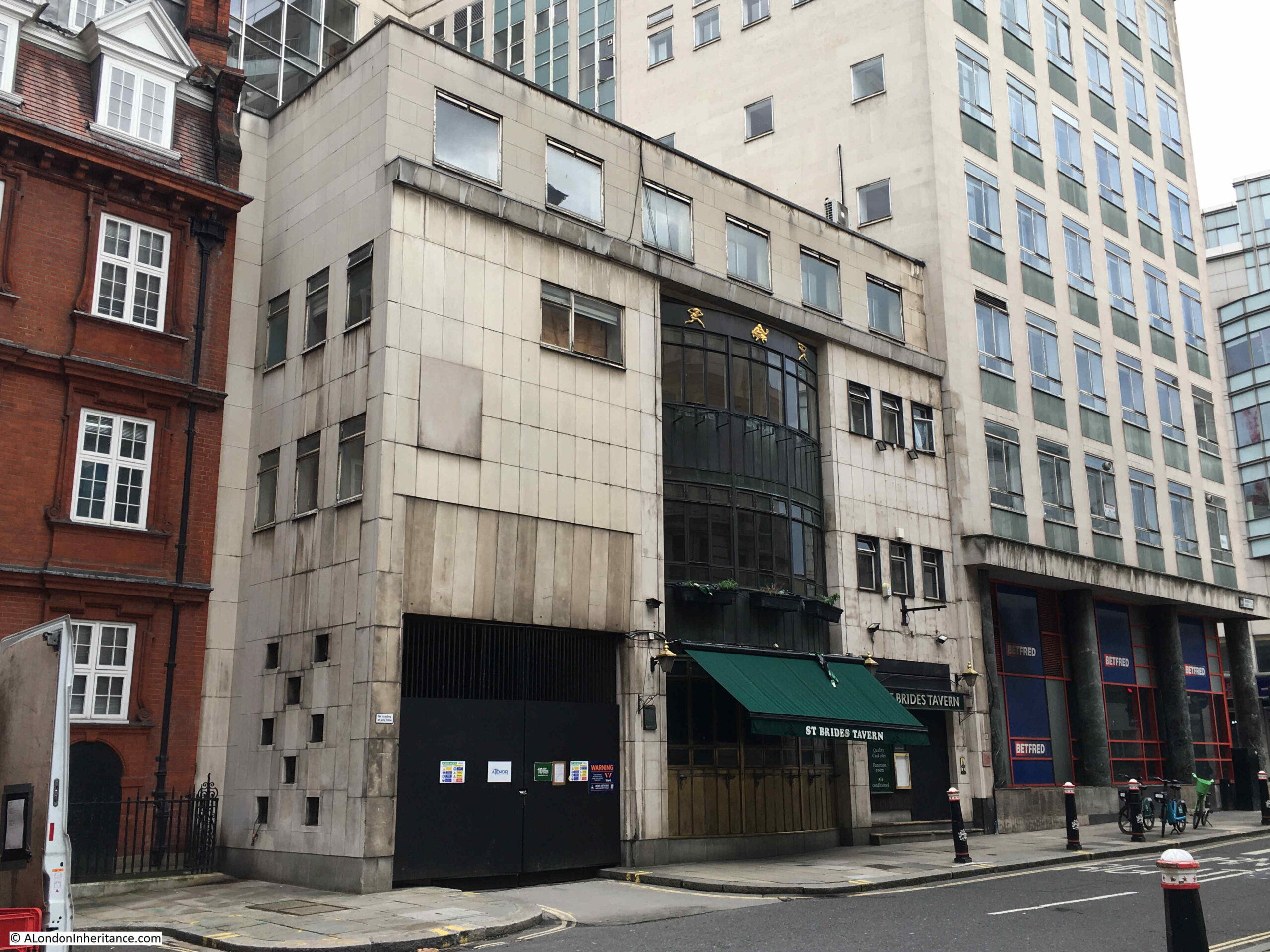
Since that post, just three years ago, three pubs have closed. The White Swan in Fetter Lane has been demolished, the Tipperary in Fleet Street has been closed for some time and it is doubtful if it will reopen, and the latest pub to close is the St. Bride’s Tavern in Bridewell Place, which I photographed a couple of weeks ago:
It was not down to a post pandemic lack of trade, or any financial problems with the pub, it was that the owner of the property would not let the pub renew the lease in January 2023, so the pub closed on Friday the 23rd of December 2022.
The owner of the land plans to strip back the office block to the right of the pub in the above photo, demolish the pub, and rebuild the building on the right with a new extension where the St. Bride’s Tavern is now located. to create a much large office block.
There was a well supported application to the City of London Environment Department to nominate the St. Bride’s Tavern as an Asset of Community Value, however this did not work, and closure went ahead.
With the trend of recent years for greater working from home, and a general decline in the need for office space, I really do wonder why establishments such as the St. Bride’s Tavern need to be demolished to create new office space.
The City of London was also planning to pivot more towards heritage, culture, arts and tourism as a response to post pandemic working, and retaining pubs would align with this strategy, however the City is being reasonably successful in tempting businesses to move back to the City from Canary Wharf as companies such as HSBC let go of large office space in the Isle of Dogs, in favour of smaller offices in the City.
An image of the new development can be seen on the website of the company that secured planning approval for the development. Click here to see the news item.
The image at top left shows the smaller extension of the new development to the rear of the main building on New Bridge Street, and the details of the development include the statement that there will be a “re-provided public house at ground-floor and part-basement level”, however a pub as part of the ground floor and basement of a modern office block just does not have the character and attraction of a dedicated building.
The building in which the St. Bride’s Tavern was located is not particularly attractive. A post-war development, which does have a rather unusual central bay of windows that runs up to include the second floor. This always looked good in the evening when the bay windows were lit.
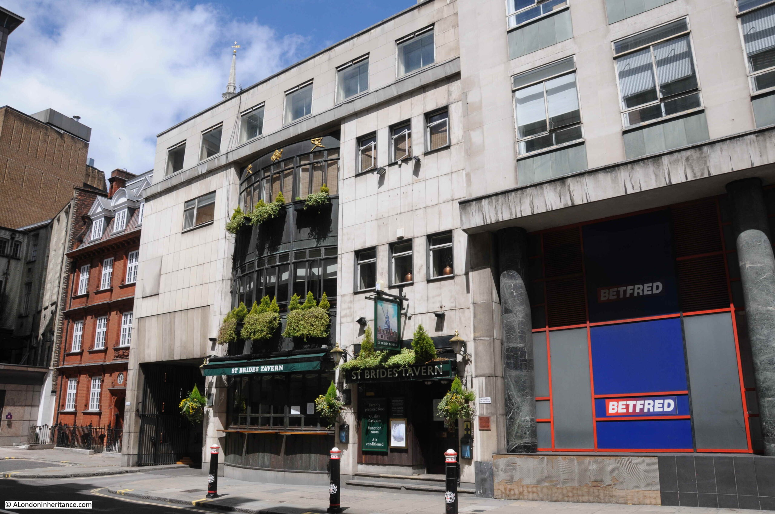
The following photo shows St. Bride’s Tavern when it was open back in 2020:
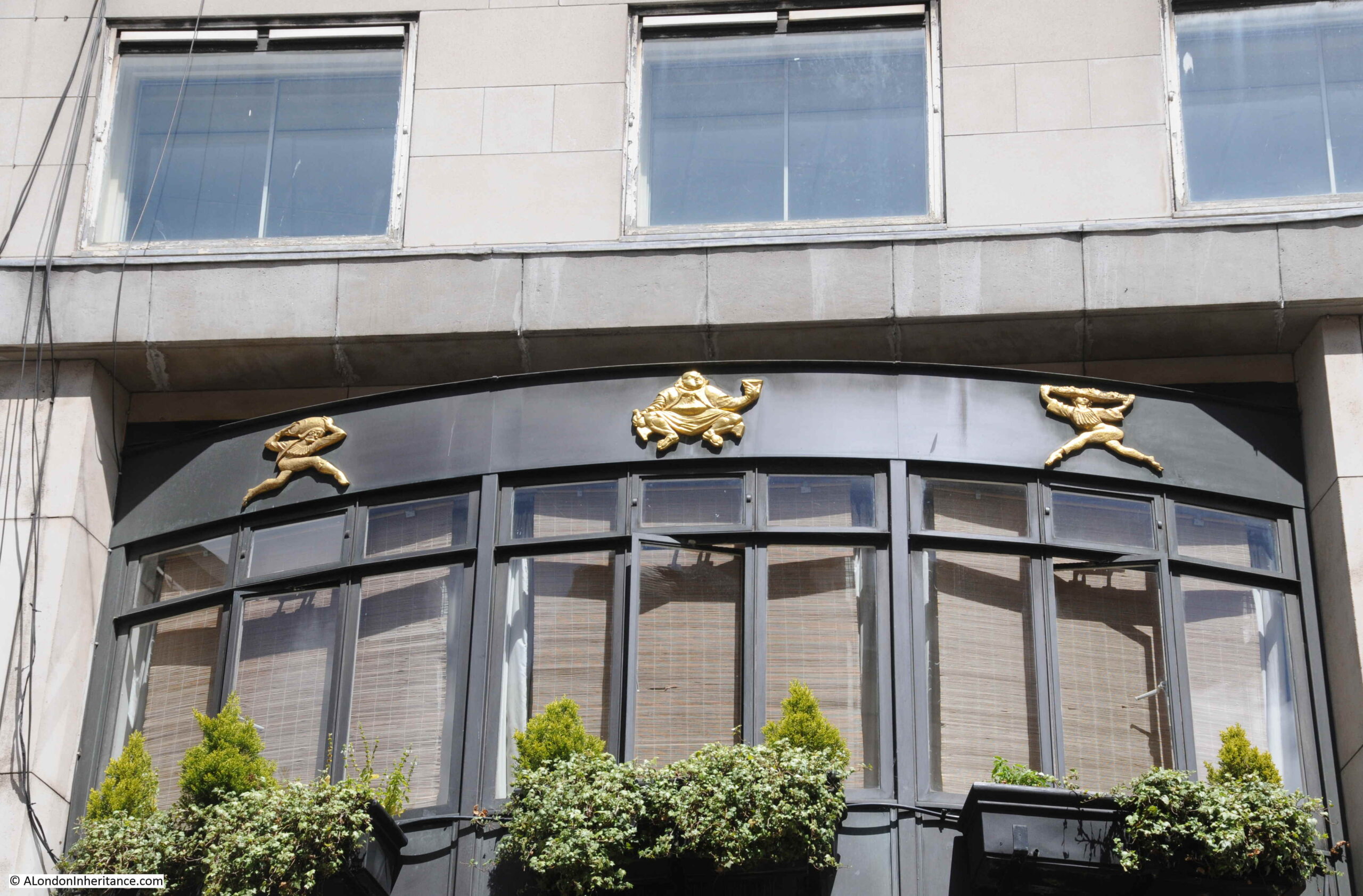
Decoration at the top of the bay windows:
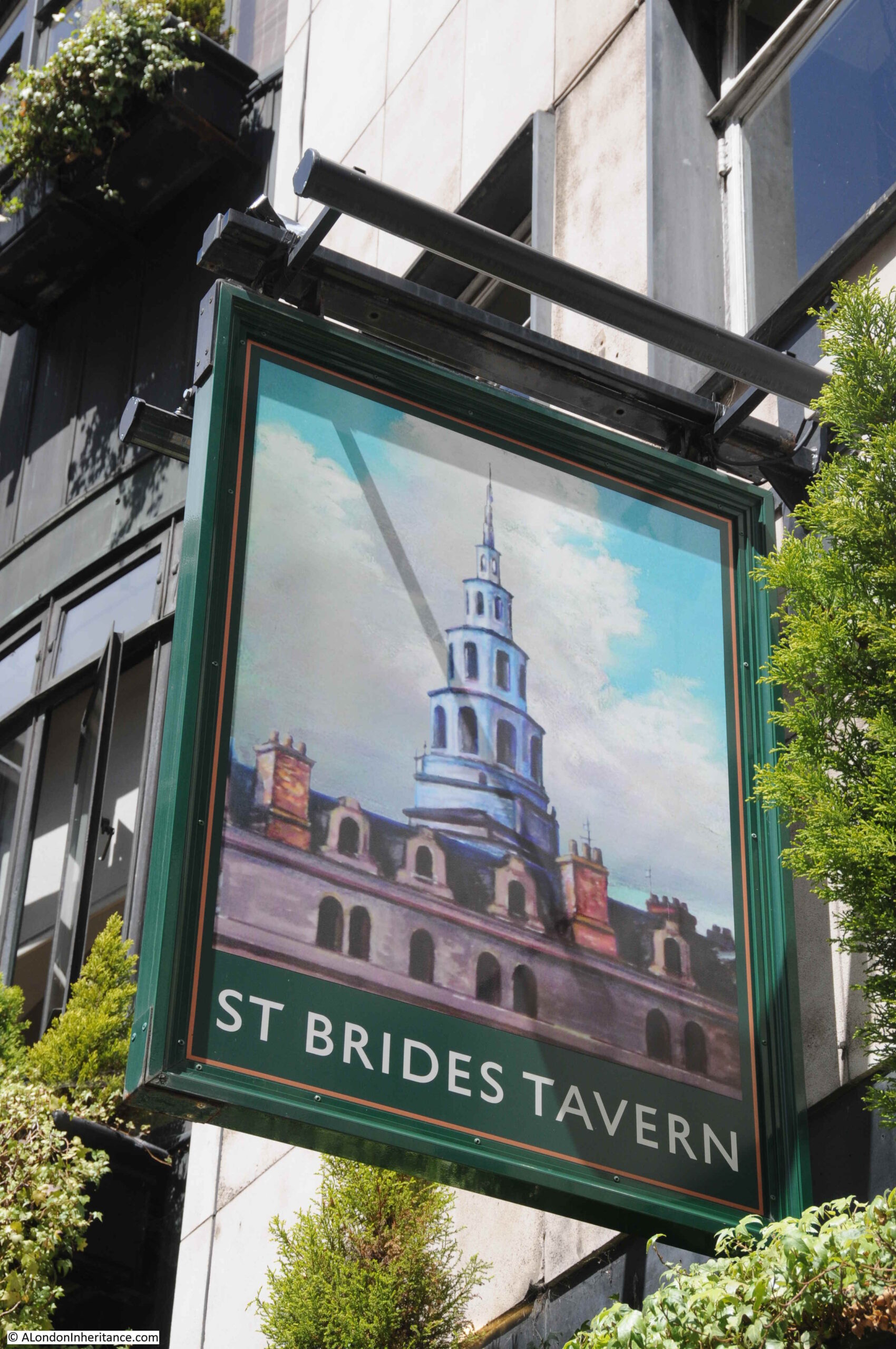
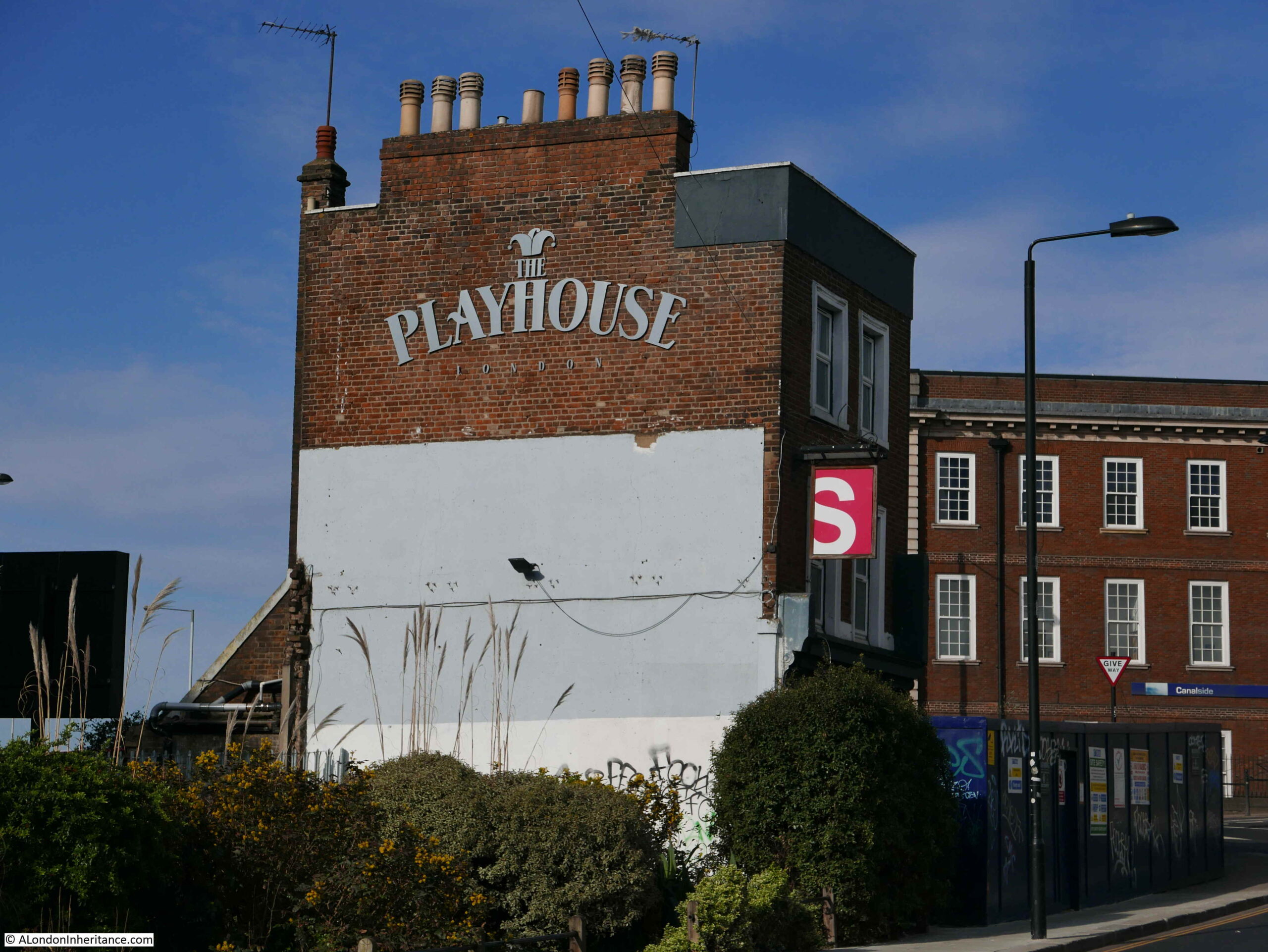
The pub sign has been removed, however I did photograph the sign back in 2020, which showed the tower of the church after which the pub was named:
The pub is a post war building as the pre-war buildings on the site had been damaged during the war.
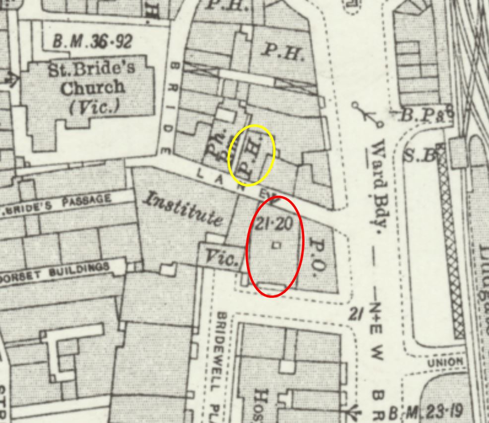
I am not sure that the site of the pub today is the original site of the pub as in the 1894 Ordnance Survey map it was not marked as a Public House and the building on the site appears to have been occupied by a Police Station of the 3rd Division.
Searching through old newspaper reports about the pub and a St. Bride’s Tavern appears to have been in the street behind the current pub – Bride Lane, for example in the Daily News on Saturday October the 19th, 1901, the pub was up for sale: “Freehold ground rent of £100 per annum, exceptionally well secured upon those fully-licensed premises, licensed as the White Boar, but also known as the St. Bride’s Tavern, Bride-lane, Fleet-street”.
Also, in the East London Observer on the 8th of December, 1900, there was a report on the marriage of Charles Seaward who was the Licensed Victualler of the Drum and Monkey pub in Whitecross-street and Miss Clara C. Wilkins, the manageress of the St. Bride’s Tavern, Bride-lane, Ludgate Circus. The wedding took place at St. Bride’s Church and the wedding breakfast was held in the St. Bride’s Tavern, from where the newly married couple would leave, later in the day, for a honeymoon in Brighton.
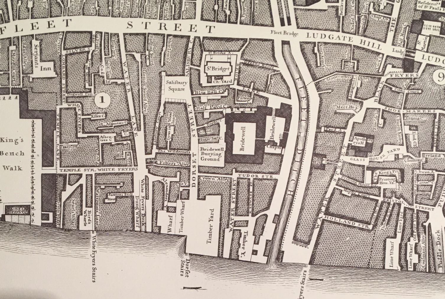
In the following extract from the 1894 OS map, I have ringed the current site of the St. Bride’s Tavern in red (and not labelled as a public house), and the pub that I believe was the original White Boar / St. Bride’s Tavern in yellow, and in the 1951 revision of the OS map, the pub in Bride Lane is still marked, with the space of the current pub an empty space (‘Reproduced with the permission of the National Library of Scotland“):
The current St. Bride’s Tavern building does extend all the way between Bridewell Place and Bride Lane, so I suspect that the original pub may have wanted a larger site, and had available the land almost directly opposite, with the new pub still retaining an aspect (although the rear) onto Bride Lane.
If the site of the current pub was also the site of the original, it would have faced onto Bride Lane so could have had that address, but it was not marked as a public house in the OS map.
The St. Bride’s Tavern is named after the nearby church, as the image on the pub sign confirms, however the pub is in Bridewell Place, which is a very historic name and location.
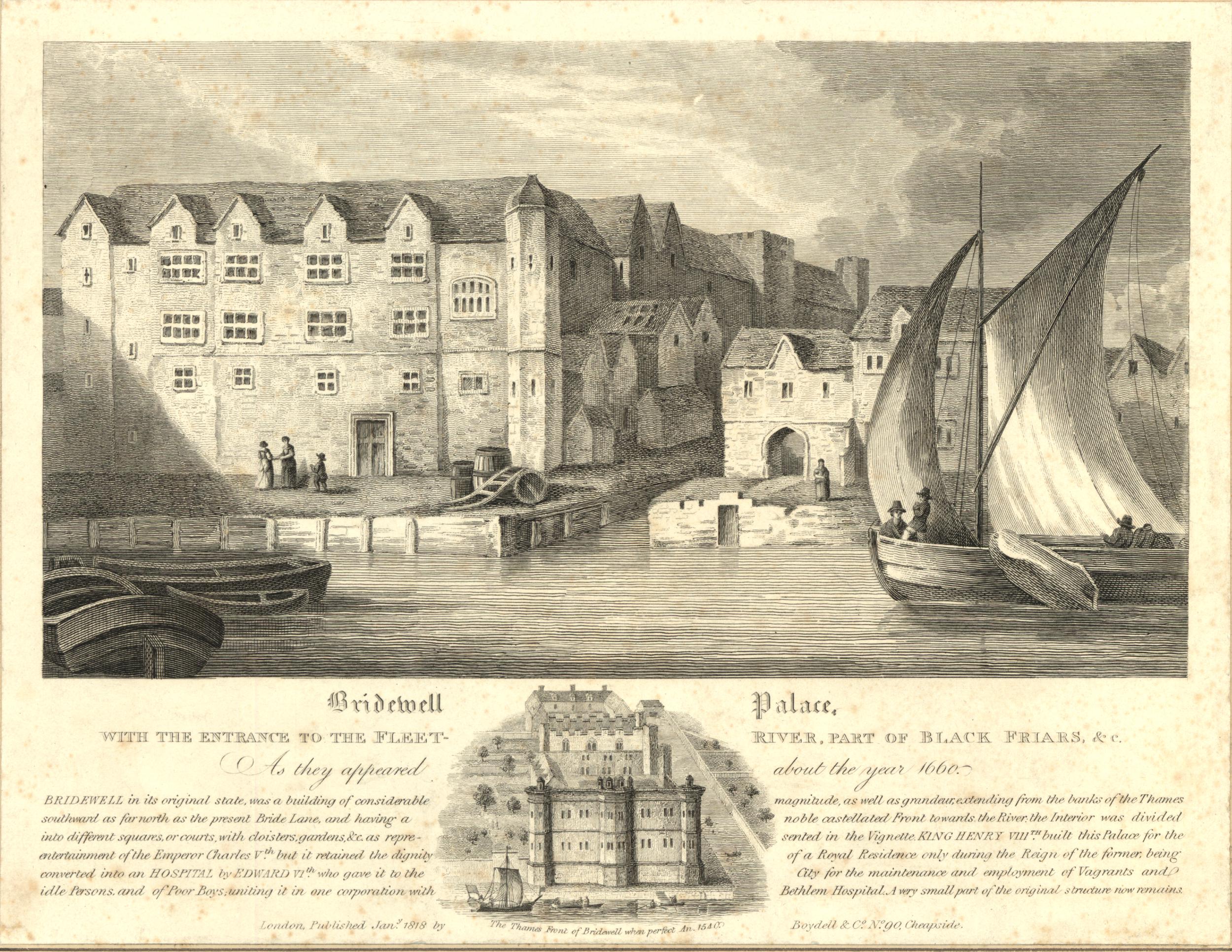
The name Bridewell originally came from a well between Fleet Street and the Thames, which was dedicated to St. Bride. The name Bridewell was also given to what was described as a “stately and beautiful house” built by Henry VIII in 1522.
London Past and Present, by Henry B. Wheatley (1891) provides the following information: “Built by Henry VIII in the year 1522 for the reception of Charles V of Spain. Charles himself was lodged at Blackfriars, but his nobles in this new built Bridewell, ‘a gallery being made out of the house over the water (the Fleet) and through the wall of the City into the Emperor’s lodgings at the Blackfriars”
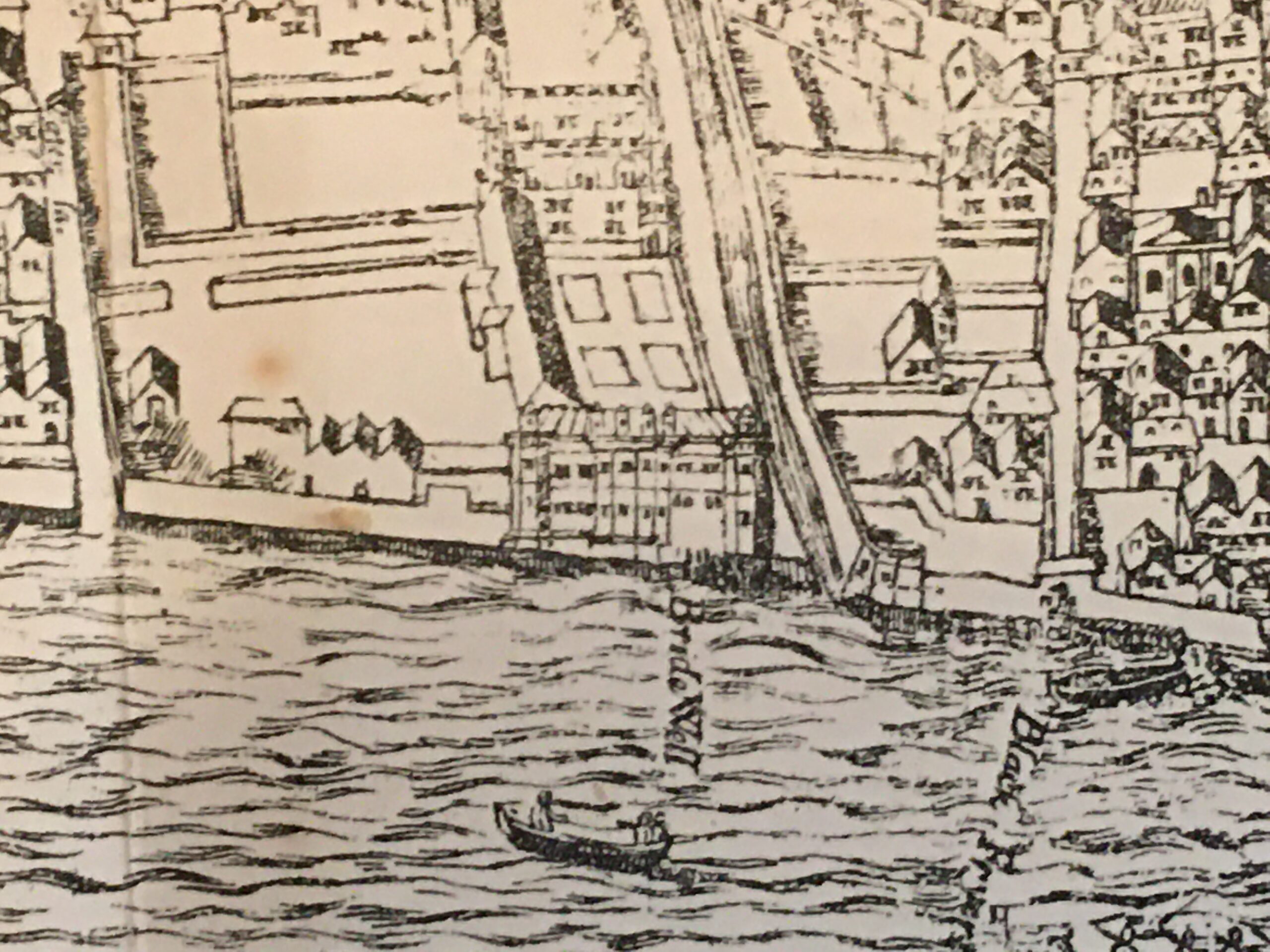
The Agas map includes an image of Bridewell, alongside the Fleet and part of which looked onto the Thames. In the 16th century the bank of the river was further in land than the river is today:
We can see what was by the 17th century, the narrow entrance to the Fleet, Bridewell on the left bank and part of Blackfriars on the right.
The print provides the following background: “Bridewell in its original state , was a building of considerable magnitude, as well as grandeur, extending from the banks of the Thames southward, as far north as the present Bride Lane, and having a noble castellated front towards the river, the interior was divided into different squares or courts with cloisters, gardens &c. as represented in the vignette. King Henry VIII built this Palace for the entertainment of the Emperor Charles V, but it retained the dignity of a Royal residence only during the former, being converted into an Hospital by Edward VI who gave it to the City for the maintenance and employment of vagrants and Idle Persons and of Poor Boys uniting it in one cooperation with Bethlem Hospital. A very small part of the original structure now remains.”
So if Henry VIII’s Bridewell extended as far north as Bride Lane, then the St. Bride’s Tavern of today is located inside the very northern edge of the old palace.
London Past and Present, by Henry B. Wheatley (1891) provides the following regarding the change in use of the building: “Bridewell, a manor or house, so called – presented to the City of London by King Edward VI, after an appeal through Mr. Secretary Cecil and a sermon by Bishop Ridley, who begged it of the King as a workhouse for the Poor, and a house of Correction ‘for the strumpet and idle person, for the rioter that consumeth all, and for the vagabond that will abide in no place”.
The problem for the new institution was that the availability of food and lodgings in the workhouse attracted people from across London, and it was “found to be a serious inconvenience. Idle and abandoned people from the outskirts of London and parts adjacent, under colour of seeking an asylum in the new institution, settled in London in great numbers, to the great annoyance of the graver residents.”
A number of children that were housed at Bridewell ended up being transported to the United States following a petition in 1618 from the Virginia Company for 100 children of the streets, who have no homes or anyone to support or provide for them. These children became part of the new colony at Jamestown.
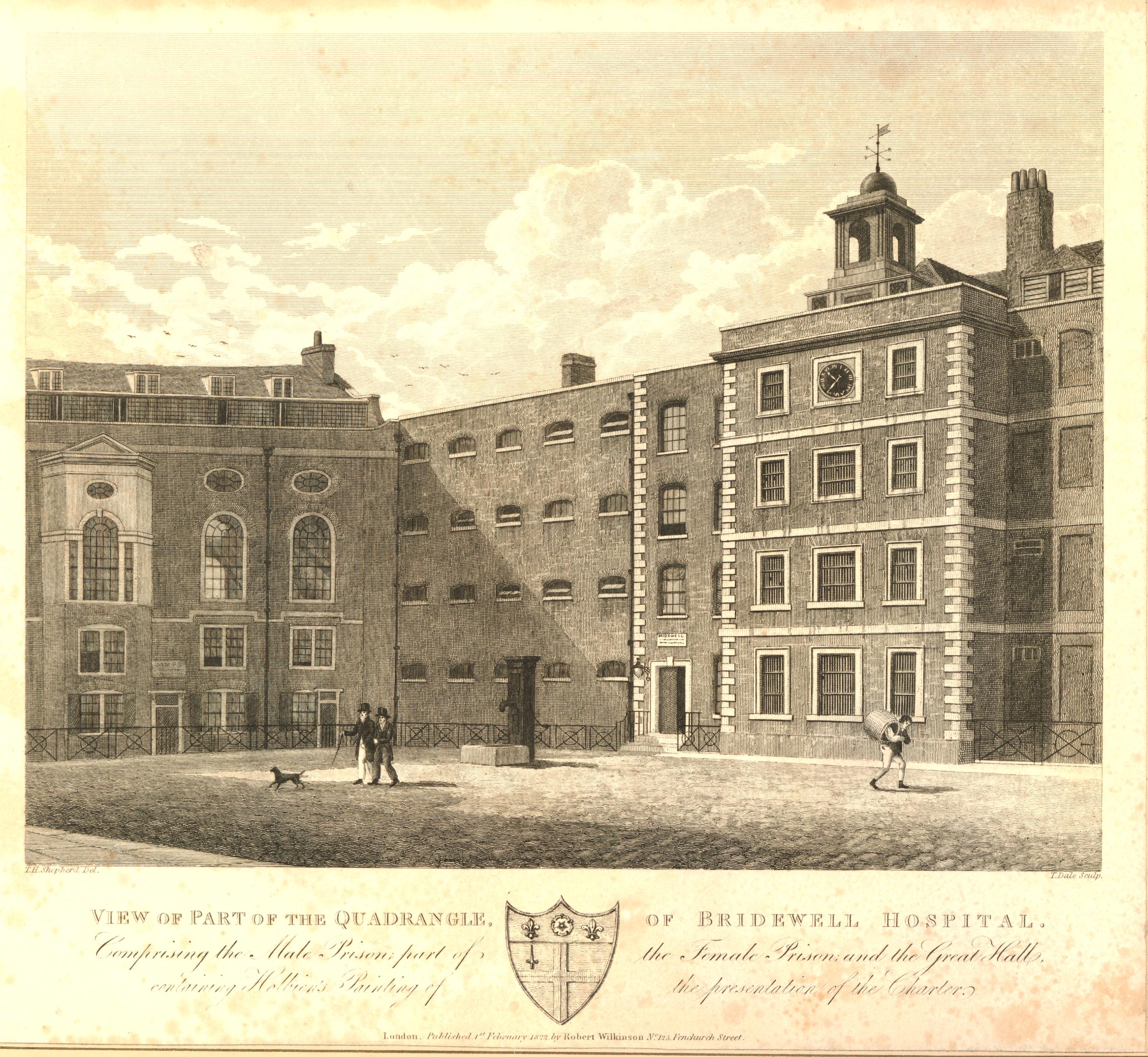
In response to complaints about the numbers attracted to the institution, the City changed parts of the buildings of the Bridewell into a granary, however in 1666 the original house and precincts were destroyed in the Great Fire.
A new house was built in a “more magnificent and convenient manner than formerly”, and these new buildings, based around two central courtyards, can be seen in the centre of the following extract from Rocque’s 1746 map:
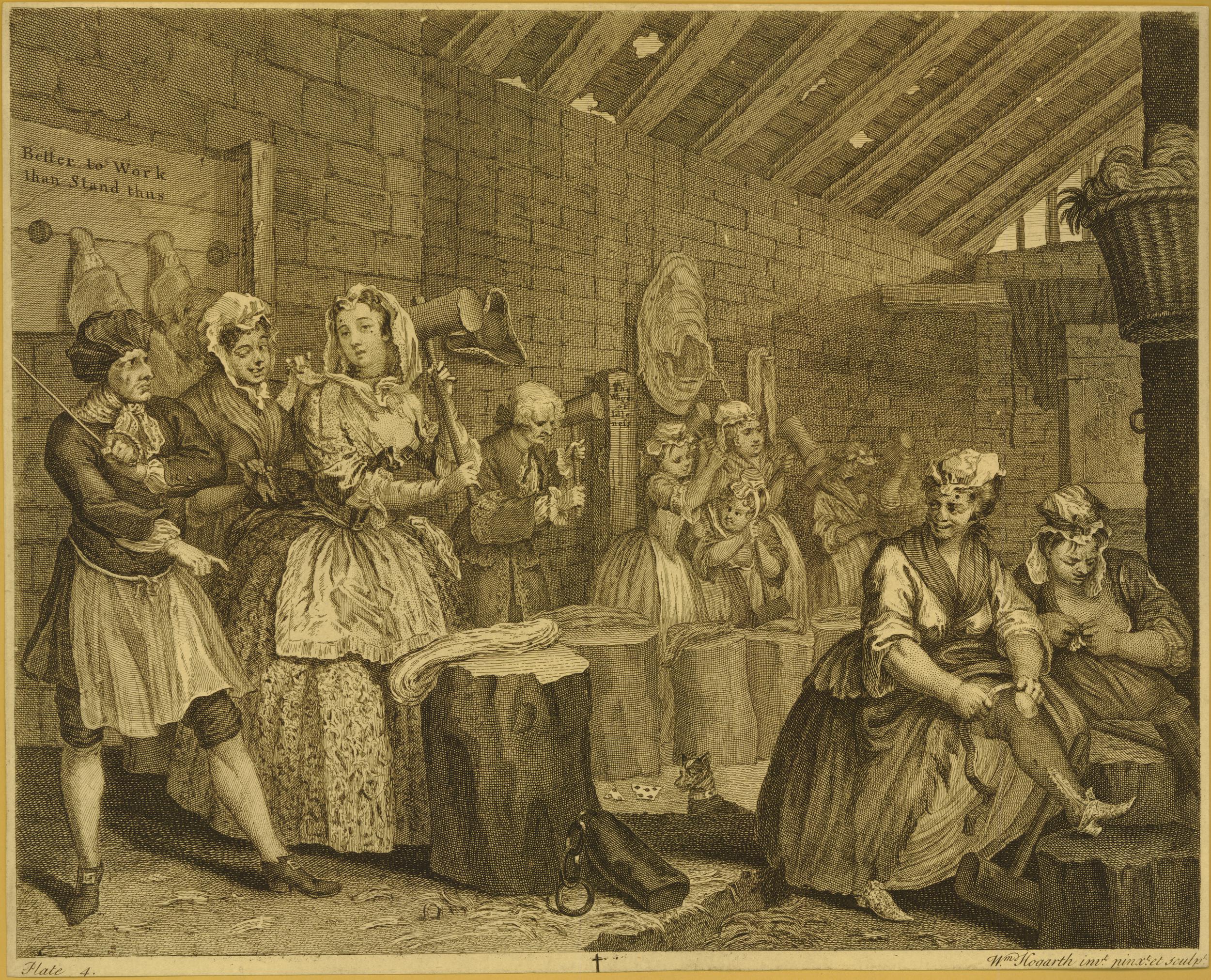
In the early 18th century, Bridewell was a place where are “maintained and brought up in the diverse arts and mysteries a considerable number of apprentices”, however “vagrants and strumpets” were still being committed into Bridewell with an average of 421 per year, with a peak of 673 in 1752.
Bridewell took on the role of a prison, and as well as holding a City Magistrates Court, the buildings also had seventy cells for male offenders and thirty for female.
Taking one year, 1743, we can get a view of some of the reasons why Londoners were being taken to Bridewell;
Margaret Skylight (a Fortune Teller) was committed to Bridewell for stealing a pair of diamond ear rings
On Saturday last a Man was committed to the Bridewell of this City for retailing Spirituous Liquors without a licence
Last Wednesday Francis Karver, alias Blind Fanny was committed to Old Bridewell for hawking newspapers, not being duty stamped, contrary to Act of Parliament
On Sunday Night last, a Parcel of Link-Men, who generally ply about Temple-Bar, made a sham Quarrel near that place, and got a great number of people together, several of whom had their pockets pick’d, by another Gang of Roques, who mingled with the Crowd, as has been very often practiced. We hear four Rogues have been since committed to Bridewell
Yesterday James Williamson was committed to Bridewell by Mr. Alderman Arnold, for attempting to pick the Pocket of one William Burris, last Saturday Night of his Handkerchief; while he was carrying him to the Constable, one of the Gang picked his Pocket of his Watch.
I hope I have the location of all the above correct, as by the early 18th century, the name Bridewell had become a common term for a prison, or place where someone was remanded before being put up before a judge.
In London there was a Bridewell in Clerkenwell and one at Tothill Fields, Westminster, and there were several so called Bridewell’s across the country, including one at Oxford and another at Colchester.
In newspaper reports, the name was often given as Clerkenwell Bridewell or Oxford Bridewell, whereas the original establishment seems to have been referred to as simply Bridewell or Old Bridewell.
The large numbers of apprentices at Bridewell also seem to have caused much trouble in the surrounding area. They were called Bridewell Boys, and also in 1743: “On Thursday Night last about Nine o’clock, as some Bridewell Boys were coming through Shoe-lane, they attacked two women, who ran for refuge into the Salutation Tavern near Field Lane End, the Boys followed them, and to get at them, broke the glasses of the Bar, on which one of them was seized, whereupon the others retired, but soon returned in greater numbers, armed with broomsticks, &c. and demanded their Companion; which being refused, they broke all the Windows, Lamps, and whatever else they could get at; however at length, several of them were secured, and it is hoped will meet with a Punishment due to their Crime.”
Bridewell also makes an appearance in Captain Grose’s “Dictionary of Buckish Slang, University Wit and Pickpocket Eloquence”, or the “1811 Dictionary of the Vulgar Tongue”, with the term Flogging Cove, which was used to describe the beadle, or whipper, in Bridewell.
The end of Bridewell as a prison came in the 1860s when the City Prison at Holloway was built in 1863, following which, the materials of Bridewell were sold at auction and cleared away by the following year, with the chapel being demolished in 1871.
Although Bridewell prison has long gone, the 1805 former offices of the Bridewell Prison / Hospital and entrance from New Bridge Street survives.
I have taken a photo of the building and its associated plaque several times, but cannot find them (if you knows of a cheap and efficient application for sorting and indexing thousands of digital photos, I would be really grateful), however the wonderful Geograph site came to the rescue, and the Grade II* listed building can be seen here, between the traffic lights:
The St. Bride’s Tavern will soon be similar to Bridewell – just a memory on the ever changing streets of London.
The development proposals apparently include a pub within the ground floor and basement of the new office block, but this will not be the same as the dedicated pub that currently stands on the site.
Three City of London pubs have now closed since my walk in 2020. How many more over the coming years will suffer the same fate?
All my walking tours have sold out, with the exception of a few tickets on the Bankside to Pickle Herring Street tour. Details and booking here.
In 1980 I was wandering around London trying out a new zoom lens for my Canon AE-1 camera, taking some not very good photos. One of these was of the Champion Pub at the junction of Eastcastle Street and Wells Street, with the Post Office Tower in the background:
The photo was taken from the southern end of Wells Street towards Oxford Street, and a sign for Eastcastle Street can be seen on the right of the Champion pub. I think I was trying to contrast the old pub and the new telecoms tower.
A wider view of the same scene today, with the BT Tower as it is now known, starting to disappear behind the new floors being added to the building behind the Champion:
A closer view of the pub in 2022, 42 years after my original photo:
Given how many pubs have closed over the last few decades, it is really good that the Champion has survived, although it is a shame that the curved corner of the building has been painted, and it has lost the name which ran the full length of the corner of the pub.
The large ornamental cast iron lamp still decorates the corner of the building.
The curved corner to the upper floors was a key feature of many 19th century London pubs. They were meant to advertise the pub, the name could be seen from a distance on crowded streets, and the name would often give an identity to the junction of streets.
For an example of a pub which had a very colourful corner in the 1980s, and today displays the current name of the pub on the curved corner, see my post on the Perseverance or Sun Pub, Lamb’s Conduit Street.
“Corner public house. c.1860-70. Gault brick with stucco dressings, slate roof. Lively classical detailing. 4 storeys. 3 windows wide to each front and inset stuccoed quadrant corner. Ground floor has bar front with corner and side entrances and fronted bar windows framed by crude pilasters carrying entablature- fascia with richly decorated modillion cornice. Upper floors have segmental arched sash windows, those on 1st floor with keystones and marks. Heavy moulded crowning cornice and blocking stuccoed. Large ornamental cast iron lamp bracket to corner. Interior bar fittings original in part with screens etc, some renewal.“
The “some renewal” statement refers to a few changes to the pub since it was built.
The first post-war renewal came in the 1950s. As with so many Victorian pubs across London, the Champion was in need of some refurbishment. Over 80 years of serving Wells Street, and open during the years of the second world war, resulted in the owners, the brewers Barclay Perkins, engaging architect and designer John and Sylvia Reid.
The Reid’s were better known as interior, furniture and lighting designers rather than architecture, and their changes to the Champion were mainly of design.
The large Champion name down the curved corner of the pub was a result of their work. The lettering was in 30 inch Roman, and the letters were shaded to give the impression that they had been engraved rather than painted. The new name replaced a number of old wooden signs that were mounted on the corner. The corner of the pub was floodlit at night, which must have looked rather magnificent, and ensured the pub stood out if you looked down Wells Street when walking along Oxford Street.
The interior had been rather plain and was painted in what were described as drab colours.
The Reid’s divided what had been two bars to form three, added button leather seating around the edge of the bars, restored the bar and some of the original iron tables, and they added new glass windows consisting of clear glass for the upper half and frosted, acid cut glass for the lower half.
Features inside the pub included the use of mahogany panels, etched and decorated glass windows between bars, and textured paper on the ceiling. refurbishment also included the first floor dining room.
Their refresh of the Champion pub did get some criticism as there were views that it was returning to Victorian design themes. The early 1950s were a time when design and architecture were looking at more modern forms, typified in the themes and designs used for the 1951 Festival of Britain.
The early 1950s update to the pub included plain and frosted glass on the external windows, not the remarkable, stained glass windows that we see today. These are the work of Ann Sotheran, and were installed in 1989.
They feature a series of 19th century “champions”, with figures such as Florence Nightingale and the cricketer W.G. Grace.
On a sunny day, these windows are very impressive when seen from inside the bar:
The missionary and explorer David Livingstone:
Newspaper reports mentioning the Champion cover all the usual job adverts, reports of crime and theft etc., however I found one interesting article that hinted at what the inside of the pub may have been like in the 1870s.
In September 1874, the Patent Gas Economiser Company held their first annual general meeting, where they reported that they had installed 50 lights in the Champion. Seems a rather large number, but spread across three floors, entering the pub in the 1870s would have been entering a reasonably brightly lit pub, with the hiss of gas lamps and the associated smell of burning gas.
The same report also mentions that the company had installed 1000 lights at the Royal Polytechnic Institution in Regent Street, 600 lights in the German Gymnastic Society in St Pancras Road, and 50 lights in the Hotel Cavour in Leicester Square.
To the left of the Champion pub, along Wells Street, building work is transforming the building that was here, and is adding additional floors to the top, which partly obscures the view of the BT Tower from further south along the street:
There was one further site that I wanted to find, and this required a walk west, along Eastcastle Street.
Eastcastle Street was originally called Castle Street, a name taken from a pub that was in the street. The name change to Eastcastle Street happened in 1918. I cannot find the reason for the name change, but suspect it was one of the many name changes across London in the late 19th / early 20th centuries, to reduce the number of streets with the same name.
At 30 Eastcastle Street is this rather ornate building:
Dating from 1889, this is the Grade II listed Welsh Baptist Chapel, the main church for Welsh Baptists in London.
Eastcastle Street is a mix of architectural styles. Narrow buildings that retain the original building plots, buildings with decoration that does not seem to make any sense, and rows of the type of businesses that frequent the streets north of Oxford Street.
At the end of Eastcastle Street is the junction with Great Titchfield Street and Market Place:
In the above photo, Great Titchfield Street runs left to right, and the larger open space opposite is part of Market Place.
The name comes from Oxford Market, a market that originally occupied much of the space around the above photo, with the market building on the site of the building to the left, and the open space in the photo being part of the open space around the market building.
Rocque’s map of 1746 shows Oxford Market, just north of Oxford Street:
Oxford Market had been completed by 1724, however the opening was delayed as Lord Craven, who owned land to the south of Oxford Street feared what the competition would do to his Carnaby Market, however Oxford Market was finally granted a Royal Grant to open on Mondays, Wednesdays and Saturdays.
The market was built to encourage activity in the area, as the fields to the north of Oxford Street were gradually being transformed into streets and housing.
The market took its name, either from Oxford Street to the south, or more likely, Edward, Lord Harley, the Earl of Oxford who was the owner of the land on which the market was built as well as much of the surrounding land.
Harley had come into possession of the land through his wife, Lady Henrietta Cavendish Holles, who was the only child of John Holles, the Duke of Newcastle, the original owner of the farmland around Oxford Street.
The original market buildings were of wood, and the market was rebuilt in a more substantial form in 1815. The following view of the second version of Oxford Market comes from Edward Walford’s Old and New London:
We can get a view of what was for sale at Oxford Market from newspaper reports:
February 8th, 1826 – john Wollaston & Co were selling their Gin in quantities of no less than 2 gallons at a price of 15 shillings per gallon
January 20th, 1824 – A “Great Room” of 45 feet square in the interior of the market was being advertised as being suitable for upholsterers, warehousemen and flower gardeners. The room was fitted with an ornamental stone basin and fountain and was suited for a flower garden
April 25th, 1841 – The Oxford Market Loan Office was advertising loans of Ten Guineas, Ten and Fifteen Pounds, which could be had from their office at the market
May 18th, 1833 – Rippon’s Old Established Furnishing Ironmongery Warehouse was advertising Fire Irons, Coal Scuttles, Knives and Forks, Metal Teapots and Tea Urns for sale from their warehouse at the market
December 15th 1827 – The lease of a Pork Butcher and Cheesemonger store at the market was being advertised. The store had been taking in £3,800 per year
June 27th, 1801 – Several lumps of butter, deficient in weight, were seized by the Clerks of the Oxford Market and distributed to the poor
So traders in the Oxford Market were selling a wide range of products, butter, pork, teapots and coal scuttles, flowers and gin, and you could also take out a loan at the market.
Nothing to do with Oxford Market, however on the same page as the 1801 report of butter being seized, there was another report which tells some of the terrible stories of life in London:
“Wednesday were executed in the Old Bailey, pursuant to their sentences, J. McIntoth and J. Wooldridge, for forgery, and W. Cross, R. Nutts, J, Riley and J. Roberts, for highway robbery. The unfortunate convicts were all men of decent appearance, and their conduct on the scaffold was such as became their awful situation.
Some of the above prisoners attempted on Monday to make their escape from Newgate through the common sewer – they explored as far as Milk-street, Cheapside, when the intolerable stench and filth overpowered their senses; with great difficulty they found their way to the iron-grating and intreated by their cries to be liberated. assistance was immediately procured, when they were released without much difficulty.”
These two paragraphs say so much: that you could be hung for forgery, the statement that their conduct on the scaffold was “such as became their awful situation”, and their desperation in seeking an escape via the sewer. Milk Street is roughly 568 metres from the site of the Old Bailey so they had travelled a considerable distance in an early 19th century sewer.
Back to Oxford Market, and the following view is looking down Market Place towards Oxford Street which can be seen through the alley at the end of the street:
In the above photo, the market building was on the left, and open space in front of the market occupied the space where the building is on the right, the corner of which is shown in the following photo. The block was all part of the open space in front of Oxford Market.
Oxford Market was never really a financial success. For a London market it was relatively small which may have limited the number of suppliers and the range of goods available.
By the late 1830s, part of the market had been converted into offices from where out-pensioners of Chelsea Hospital were paid.
The market buildings was sold in 1876, demolished in 1881, and a block of flats built on the site.
Although Oxford Market is long gone, the street surrounding three sides of the old market building is still called Market Place, and the footprint of the building, and the surrounding open space can still be seen in the surrounding streets, and the wider open space and restaurants along the northern stretch of Market Place.
Last week, I featured a pub in Belgravia that is still there. For today’s post, I am in Ladbroke Grove to visit the site of a lost pub. This is the Narrow Boat on Ladbroke Grove, adjacent to the bridge over the Paddington Arm of the Grand Union Canal.
This was the Narrow Boat pub in 1986:
The pub has disappeared, bridge rebuilt, and the Narrow Boat has been replaced by a block of flats:
My father took the 1986 photo, and I have no idea whether including the passing cars in the frame was intentional or accidental. Chauffeur driven cars, and I do not recognise the man sitting in the rear of the car on the right.
If the passing cars were accidently included in the frame, this was the days of film, so taking another when there was a risk of more traffic in the view was often an inefficient use of film. Very different to today when you can take as many digital photos as needed to get the right view.
An area I have not written about before (there are so many still to do). The large area of green space to the left of the pub is Kensal Green Cemetary, which is well worth a visit.
The Narrow Boat was a relatively recent name for the pub. It had originally been called the Victoria. The name changed in 1977 when the Chiswick brewer’s Fuller, Smith and Turner took over the pub. A news report of the change in ownership records that the name change was in keeping with the pub’s proximity to the Portobello Docks, and the narrow boats that carried goods along the canal. The new landlords of the pub were also new to the pub trade. Wally Sharpe had been a London cab-driver for eleven years and Irene Sharpe had been a civil servant.
They had plans to completly refurbish the pub, and for a beer garden and the build of a landing stage on the canal for passing canal traffic.
Judging from the exterior of the pub just nine years later, I am not sure how many of these plans came through to completion. I suspect that Wally and Irene were just ahead of their time, and a pub with gardens facing onto the Grand Union Canal could now be rather profitable, especially as the area is not particularly well served with pubs.
I cannot find the exact date when the pub opened. There are newspaper references to the Victoria pub in the 1890s. In the late 19th century this was on the edges of built London with still many fields to the north and west. Kensal Green Cemetary had opened in 1833, making use of the amount of open space available in the area.
The Paddington arm of the Grand Union Canal opened in 1801 to provide a link between Paddington Basin and the main Grand Union Canal which connected with Birmingham and much of the rest of the country’s canal network.
The Victoria may not therefore have been opened much earlier than the 1890s, unless it was built to serve those passing on the canal.
In the late 1970s, the Marylebone Mercury had a regular beer column and on the 14th September 1979, one of the improvements to London pubs was the fitting of hand pumps in Fullers pubs, with fifty so far being upgraded to return to more traditional ways of serving beer. The Narrow Boat was included in the list of pubs in which the author of the column would enjoy a pint.
in the same year, the beer column commented that the Narrow Boat pub had been included in the Campaign for Real Ale’s 1979 edition of the Good Beer Guide.
Earlier mentions of the pub include a report in 1912 into the drowning of an eight year old boy who had been fishing in the canal. Joseph Church, the landlord at the time was one of those trying to rescue the boy and was called as a witness at the inquest.
In 1902, the Kilburn Times reported on the trial of a drinker in the Victoria who was charged with disorderly conduct and assaulting a Police Constable. In a strange turn of events, the drinker was found innocent after evidence presented, including from the pub’s landlord, proved that the Police Constable had intimidated and assaulted the drinker. The Police Constable was reported.
Apart from that, the Victoria / Narrow Boat appears to have passed a reasonably quite life servicing the locals, workers on the canal, and those from the gas works opposite.
The following photo is looking to the west, from the bridge that carries Ladbroke Grove over the canal.
Parts of Kensal Green cemetary can just be seen on the right, and the large building in the distance on the left is a Sainsbury’s store. The area on the left was once occupied by a large gas works.
The view over the opposite side of the Ladbroke Grove bridge, looking towards the east.
There has been, and still is much development in the area. This is St John’s Terrace which originally ran from Harrow Road to the rear of the Narrow Boat. The building that has replaced the pub can be seen at the end of the street.
On the corner of St John’s Terrace and Harrow Road is the closed premises of the Tyre and Wheel Company, which has been closed for some time, and I assume is waiting for demolition and probably the build of new flats.
Walking back south along Ladbroke Grove, over the bridge and turning into Kensal Road is the boarded up remains of another pub. This was the late 19th century Western Arms.
The Western Arms originally had a large single storey ground floor bar running to the right of the three storey block, however this looks to have been recently demolished,
The pub was called the Playhouse during its last years as a pub, finally becoming a cocktail bar / performance venue. The old pub occupies a reasonably large corner plot so could easily suffer the same fate at the Narrow Boat, however as the three storey block has so far been left standing there is some hope that this will be retained, and the building retains a similar function to that performed during its time as a pub.
A short walk along Kensal Road offers other buildings of interest. This is “The Gramophone Works”:
The name comes from the building being the home of Saga Records Ltd during the 1960s and 70s.
The site was purchased in 1960 by Marcel Rodd, who purchased Saga Records the following year.
Saga Records was one of the first companies to reduce the cost of records, to try and break up control of the market by the major music companies. The majority of their music publishing appears to have been classical records, however they also included jazz and West End shows in their catalogue. In 1966 on their Saga EROS label they released the soundtrack to West Side Story by the original English cast.
A short distance further along Kensal Road is another closed pub. Again, from the 19th century and with the wonderful original name of “Lads of the Village”.
The pub features in a number of interesting news reports. The earliest I can find dates from 1864, so I suspect the pub dates from the 1850s, or very early 1860s. The headline in the 1864 article gives an indication of trouble, and the fact that this area was then a very new development:
“Riot at Kensal New Town – Mr Alfred Price, the landlord of the ‘Lads of the Village’ beershop, Kensal New Town, said: Yesterday morning I left my house a little after six o’clock. I closed the house, barricaded and locked the tap-room door which opens into the street. I bolted the bar door, and went out by the front door, which closed with a spring lock.
I returned between six and seven o’clock the same morning, after taking a walk. I found the tap-room door broken open, and all these men there. Shay was behind the bar acting as landlord. I had porter and ale on the engine, and he was drawing from it. I saw eight pots of beer filled and a half-gallon can, also full, on the counter. The others were partaking of the beer, and giving it away as well to parties outside and others inside.
I said ‘How dare you force into my premises and give away my beer’ Shay merely laughed. They continued drawing the beer and drinking it, in spite of me. I saw Foley and Gadstone shortly afterwards, and they partook of the beer. I went for the police at eight o’clock, and returned with a constable. There were about 40 gallons of beer and ale on draught at the time. I find the barrels are drained and the bung of another barrel had been taken out and the contents were wasted”.
Foley was jailed for three months for assaulting a policeman, and the judge ordered a police inspector to investigate further.
The name of the pub was frequently abbreviated to just The Village, however not that long ago changed name to Frames, although it did not last long with the new name, closing in 2016, and no indication of when current work will complete, and what the old pub will eventually become.
Returning back up Kensal Road to the location of the Narrow Boat pub and looking across the bridge is a rather unusual structure:
This is an old water tower that was originally built in the 1930s to hold 5,000 gallons of water ready to use if parts of the adjacent gas works caught fire.
The water tower was converted for designer Tom Dixon by the architectural practice SUSD Architects. Building work was completed in 2012, with additional floors added to the water tower to provide a kitchen, two reception rooms, two bathrooms and two bedrooms.
There were originally plans to extend accommodation down to ground level, hiding the four concrete legs, however these plans do not seem to have made any further progress since the initial conversion.
The building is in a strange location. There must be good views over the surrounding area as there is nothing of similiar or greater height to block the view.
Access is via the temporary looking scaffold stairs to the side of the tower.
A walk round to the side of the Sainsbury’s car park provides another view of the tower:
No idea if anyone is living in the converted water tower at the moment, but it would be a rather interesting place to stay, and look out over the canal, and the streets of Ladbroke Grove, Kensal Green and Kilburn.
All the locations covered in this post are within a five minute walk of the Ladbroke Grove bridge over the Grand Union Canal. In that short distance, there were once three pubs. One, the Narrow Boat has completely disappeared, and the future does not look good for the remaining two empty buildings.
I have many more 1980s London pubs to visit, some remaining, some lost, however I will break these up after two weeks of pubs and return to these again in the coming months – and hopefully when we can go inside.
Thirty five years ago, my father was outside the Pilot in Greenwich. Located on the peninsular which now has the O2 Dome at the northern tip, the Pilot is one of the very few original buildings left after the recent and ongoing development of the Greenwich peninsula.
The Pilot pub in 1985:
Last week I returned to the Pilot to take a comparison photo and for a beer. Although redecorated, and no longer a free house, the pub looks very much the same.
The Pilot is at the end of a short terrace of houses, originally going by the name of Ceylon Place.
From the above map, it is hard to appreciate the level of development on the peninsula. The O2 Dome, or Millennium Dome as it was, kick started development of the area, and after a use was finally found for the dome as a major London concert venue, development on the peninsula has been a permanent activity, with apartment towers, offices and hotels of strange design rising from this once industrial landscape.
The Pilot and the terrace at Ceylon Place have are remarkable history, dating back to the early development of this part of Greenwich. The level, and type of change over the last couple of hundred years has been such that the pub and terrace have been surrounded by incredibly different landscapes.
We can explore these by looking at maps. The above map extract shows the area now dominated by the O2 Dome, and the associated developments, however, going back to 1951, and this was a very industrialised place. The Pilot and terrace is highlighted by the red oval in the following map extract (Following maps: ‘Reproduced with the permission of the National Library of Scotland’:
There are a few other terraces, in addition to Ceylon Place, however the majority of the land is occupied by Gas Works, Tar Works, Electricity Generation, a Steel Works, and many other smaller industrial sites. The following map extract is an enlargement of the area around the Pilot and Ceylon Place, which are in the centre of the map.
The pub and terrace face onto River Way which leads down to the Thames. A cooling pond occupies much of the space directly opposite. A railway runs to the west, Behind the terrace is a steel works.
Much of the development of the peninsular was during the later part of the 19th and early 20th century. If we go back to 1893, we can see the start of the industrialisation of the peninsular.
The Pilot pub and Ceylon Place can be seen, with a longer terrace that stretched to the east. Much of the immediate surroundings are open space, and the railway has not yet arrived. The area to the south are the Greenwich Marshes.
Looking at an extract from the above map, we can see the terrace in 1893, with the Pilot (labelled P.H.) at the western end of the terrace as it still is today.
At the eastern end of the terrace, there is a large building called East Lodge with open space leading down to the river and bays on either side – presumably bay windows to provide a good view of the Thames.
The majority of the terrace, and East Lodge would disappear in the coming years. By the 1913 Ordnance Survey map, East Lodge had gone. and by 1939 much of the terrace had also been lost, leaving only Ceylon Place we see today, and the Pilot pub.
In all this time, the Pilot has looked out over a very different landscape. Once surrounded by open space and marsh land, the Pilot was then surrounded by some of the most polluting industries to be found in London, then as industry in the area closed, the pub looked out on a derelict landscape.
Today, the Pilot looks out on yet another very different landscape. A ten minute walk from the O2 Dome, in the middle of a green space, and in the process of being surrounded by tower blocks of ever more outlandish design.
The Pilot and the terrace date from 1801. A plaque on the front of the pub to the upper left of the main entrance confirms the date, the name Ceylon Place and New East Greenwich which was the name given to the development, as it was expected to form the basis of a larger development.
The main body of the pub is original, however, as will be seen when comparing my father’s photo, and my photo below, a smaller extension to the right has been added. This now provides accommodation, so if you want to stay on the Greenwich Peninsular, there is an option with a pub attached.
The London Metropolitan Archives Collage collection has a photo of the Pilot and terrace dating from 1979. The Pilot looks the same as in my father’s photo, with the same pub sign, however look closely at the terrace of houses and you will see three of these have their window and door bricked up. The 1970s and 80s were the time when industry in the area was in significant decline, and it is surprising that the terrace has survived to this day.
The street in front of the pub and terrace now ends in a dead end, rather than running down to the causeway that ran into the Thames. Today, blocks of apartments now separate the Pilot and terrace from the river that for much of their time, must have been a significant influence on the lives of those who lived in the houses and drank in the pub.
We can get a good idea of life in the terrace and pub by looking at old newspaper reports. When first built, the rear of the terrace looked out onto the Greenwich Marshes and a maze of ditches draining into the Thames, however in July 1857, the Kentish Mercury reported that:
“The inhabitants of Ceylon-place, East Greenwich complain of the very offensive state of the ditch at the back of their houses. They inform me that this ditch, like all other ditches on the Marshes, was formerly flushed out at every tide, but since Mr Wheatley has lately stopped up a sluice at the entrance to the ditch. The water is, therefore, become stagnant, and is certainly in an offensive state, and thereby causing the nuisance complained of”.
There were the day to day events that would have had significant personal impact, to those who lived in the terrace. On the 30th May 1840:
“POOR MAN’S LOSS – On Saturday evening last, as a poor labouring man was going home, after work, he lost the whole of his wages, amounting to 30s, besides some papers which, to the owner, are of consequence. The finder of the documents would be doing an act of great kindness by forwarding the same to No. 3, Ceylon Place, Greenwich”.
There was the type of crime common when drink was involved. In March 1903 the Woolwich Gazette reported that:
“Frederick Boos, a foreign seaman, of s.s. Hendon, was charged on Thursday at Greenwich with assaulting a waterman, named Russell Lewis, of 6, Ceylon Place, East Greenwich. The victims head was bandaged and he said he was suffering from several bad cuts, said the prisoner hit him several times without any provocation. Boos alleged that the prosecutor had been making false statements about him and that he (Boos) was drunk at the time – Two months hard labour”.
The victim, Russell Lewis is recorded as being a waterman of Ceylon Place. Checking the census data reveals that this was a common occupation for those living in the terrace in the 19th century. In the 1871 census, there were several watermen, and watermen’s apprentices among the occupants of several of the houses.
Another mention of a Waterman living at Ceylon Place is from the Kentish Mercury on the 3rd April 1885: “A PUGILISTIC WATERMAN – Charles Watkins, waterman, of 8 Ceylon-place, East Greenwich, was charged on summons of assaulting another waterman named Richard Preddy. The complainant said he was sitting on a seat at the Anchor and Hope Wharf, waiting for a ship to come up the river. He heard footsteps and saw Mr Watkins, who pulled off his coat and wanted him to fight; he told him to put on his coat, when the defendant struck him in the face, and then they both fell over the seat”.
Charles Watkins was fined 20 shillings with 2 shillings costs for the attack.
The majority of the other inhabitants were recorded as being labourers. One, a Mrs Elizabeth Elliott, widow, aged 74 was on the Parish Poor Relief. This was a very working class terrace.
There were other professions, perhaps unexpected in such an industrial area. In 1901, a resident of Ceylon Place was up before the Lord Mayor:
“THE SERIOUS CHARGE AGAINST A GREENWICH MAN – At the Mansion House on Thursday last week, Charles Rayner, aged 23, described as a music-hall artiste of Ceylon-place, Greenwich was again before the Lord Mayor on the charge of being concerned with another man in stealing £10 from the Falstaff Restaurant, Eastcheap”.
Publican’s were in danger of prosecution if they continued to sell alcohol to those already drunk, and in July 1908, in an article entitled The Peril of the Publican, it was reported that:
“Mary Ann Millington of the Pilot public-house, Ceylon-place, East Greenwich, was summoned for selling intoxicating liquor to a drunken person, and for permitting drunkenness”.
Mary Ann Millington was fined 40 shillings.
When they were living in the terrace, Charles Watkins and Charles Rayner, would have looked out on a rapidly industrialising area, but they would have still been very familiar with the last of the fields and marshes on the peninsular, and the causeway down to the river at the end of the longer terrace would have probably been used by many of the watermen of Ceylon Place.
Looking north from the terrace, the view would have been of cooling ponds and gas works. Today the view is of a park.
And replacing the electricity generating station, and steel works are now rows of apartment buildings, which also block off the direct access to the river that the watermen of Ceylon Place formerly enjoyed.
At the eastern end of the terrace. an old, painted sign provides a faded view of the original name of the terrace.
The view of the terrace hidden behind trees on the walk down from the northern tip of the peninsula:
The park is now established, but all along the eastern edge of the peninsula, building is continuing and the park is fenced off from numerous building sites. The following photo is the view looking north from the same position as the above photo. Tall buildings can be seen in the distance, to the east of the O2 Dome, and the building sites to the right are fenced off, so many more tall apartment buildings will soon overlook Ceylon Place and the Pilot pub.
The Pilot is a really lovely pub, with an open terrace at the rear which was perfect on a warm August afternoon.
The Pilot and Ceylon Place have been here for over 200 years. They were:
Built when much of the Greenwich Peninsula was still field and marsh
They saw the building off, and were surrounded by some of the most polluting industries in London
They saw the decline of these industries and the derelict state of the much of the peninsula
The Millennium Dome came to the end of the peninsula
They are now being surrounded by towers of apartment buildings, but with an open space providing a view to the north
I suspect one of the watermen, or a worker in the industries on the peninsula would never have guessed what the place would look like today, and likewise, we probably have no idea what the peninsula will be like in one or two hundred years time, but I hope the Pilot and the Ceylon Place terrace will still be there to see how this part of London develops.
Before heading to Old Barrack Yard for today’s post, a quick update to last week’s post on Seven St Martin’s Place. Thank you for all the feedback, personal links with the site and thoughts on who could have created the reliefs on the front of the building.
Through Twitter, TheTaoOfOat sent me this link to a site which included some posts from the original sculptor’s daughter. Hubert Dalwood was the sculptor who was commissioned to create the reliefs for the Ionian Bank. The material is aluminium which probably makes them rather unique.
I have been in contact with Hubert’s daughter, Kathy Dalwood, who is also a sculptor, to discover more about the background to these reliefs, and she will be letting me have some more information when she returns from travel. I have also e-mailed the developer to ask whether the reliefs will remain with the new hotel development.
Thanks again for all the feedback, it is brilliant to be able to bring some recognition to these wonderful reliefs and I will update the blog post as I get more information.
Now to the subject of today’s post – Old Barrack Yard.
I was in Knightsbridge last Tuesday on a rather wet July day. Leaving the underground station at Hyde Park Corner, I headed west along Knightsbridge, and a short distance along, turned south into Old Barrack Yard. The part I was interested in was not the street that connects directly onto Knightsbridge (which is a building site at the moment), but a bit further along after where the street turns east, there is a southern branch heading down towards Wilton Row.
My father took a number of photos of Old Barrack Yard on a rather sunny day in 1949:
Seventy years later, I photographed the same scene on a very wet day:
Although the weather conditions are very different, and my use of colour photography also tends to suggest a difference in the two scenes (I often wonder whether I should switch to black & white for these comparison photos) – the scene is very much the same, apart from some minor cosmetic differences.
The paving stones do though appear to be different in the two photos.
The name – Old Barrack Yard – provides a clue as to the history of the area.
The following map extract is from Horwood’s map of London, created between 1792 and 1795. The large block in the centre of the map is Knightsbridge Barracks.
Stabling for the Grenadier Guards were in use here around 1762, and by 1780 barracks had been fitted out, with an entrance through to Knightsbridge, allowing direct access to Hyde Park.
Ornate gardens had been created to the south of the barracks and a large yard was to the right of the barracks – part of this yard and the gardens to the south are the location of Old Barrack Yard today.
The military released the barracks in the 1830s, and the following extract from Reynolds’s 1847 map of London shows how the area had developed:
The barrack block can still be seen, and on the western edge of the original gardens, just below the barracks, is the church of St. Paul’s, built in the early 1840s. The yard can still be seen to the right of the barracks, and a crescent of housing has been built up to the corner of the church – this is Wilton Row.
Note that to the right of the old barracks block is the abbreviation “Exh” – this refers to an exhibition that was established here in the 1840s using parts of the yard and the old barracks.
The Chinese Collection was an exhibition of Chinese artifacts collected by an American merchant, Nathan Dunn, who had spent 12 years in Canton. The exhibition had previously been on display in the United States, but brought to London at the encouragement of a number of learned societies and individuals. Interest in China was high at the time with the first Opium War about to be brought to a successful close with the signing of a peace treaty with the Chinese in Nanking.
The Illustrated London News reported on the Chinese Collection in August 1842:
“Upon the left-hand side of the inclined plan, extending from Hyde Park Corner to Knightsbridge, and towards the extremity of St. George’s-place, a grotesque erection has lately sprung up with all the rapidity which distinguishes the building operations of the present day.
As the work proceeded, many were the guesses at the purpose for which it was intended; and to feed the suspense of the many thousands who daily pass this thoroughfare, the work was covered with canvas until just completed. The structure in question is the entrance to an extensive apartment filled with ‘curiosities of China’. In the design this entrance is characteristically Chinese, and is taken from the model of a summer residence now in the collection. It is of two stories, the veranda roof of the lower one being supported by vermilion-coloured columns, with pure white capitals. and over the doorway is inscribed in Chinese characters ‘Ten Thousand Chinese Things’. Such summer-houses as the above are usual in the gardens of the wealthy in the southern provinces of China, often standing in the midst of a sheet of water, and approached by bridges, and sometimes they have mother-of-pearl windows.
Although the above building is raised from the pathway, whence it is approached by a flight of steps, it is somewhat squatly proportioned. But such is the character of Chinese buildings, so that when the Emperor Kesen-king saw a perspective of a street in Paris or London he observed, ‘that territory must be very small whose inhabitants were obliged to pile their houses to the clouds;’ and, in a poem on London, by a Chinese visitor it is stated – ‘The houses are so lofty that you may pluck the stars’.
The collection we are about cursorily to notice, has been formed by the American gentleman, Mr. Nathan Dunn, who resided in China for a period of twelve years, and experienced more courtesy from the Chinese than generally falls to the lot of foreigners.
The design at first was merely to collect a few rare specimens for a private cabinet; but the appetite grew with what it fed upon, and thus Mr. Dunn has assembled what may, without exaggeration, be termed the Chinese world in miniature; and, it is equally true, that by means of this collection, we may, in some sense, analyse the mental and moral qualities of the Chinese, and gather some knowledge of their idols, their temples, their pagodas, their bridges, their arts, their sciences, their manufactures, their trades , the fancies, their parlours, their drawing rooms, their cloths, their finery, their ornaments, their weapons of war, their vessels, their dwellings, and the thousands of et ceteras.”
The approving description of the Chinese Collection in the Illustrated London News continued for a few more hundreds words. The exhibition was a considerable success, and was the place to be seen in 1842.
A view of the interior of the Chinese Collection:
The Chinese Collection exhibition closed in 1846, and in 1847 the pagoda that had been built for the exhibition at the entrance to Old Barrack Yard was purchased by James Pennethorne and relocated to an island in the lake at Victoria Park, Hackney, where it could be found until 1956.
By 1895 the barrack’s had disappeared (partly demolished in the 1840s, with final demolition in the late 1850s), and the buildings that form the lower part of Old Barrack Yard, photographed by my father, can be seen in the following map extract.
The upper part of Old Barrack Yard was still there, however this area would be developed in the 20th century, leaving Old Barrack Yard as a street that runs from Knightsbridge, turns to the east, then south into the section focused on in today’s post.
The entrance to Old Barrack Yard from the north is through a building that separates off this southern section of the street. The view from the end of the entrance arch:
The same view in 2019 on a very wet July day (although with the cloud cover, i did not have the contrast problems that my father had on a very sunny day):
Walking through the arch and this is the view looking back:
The same view today;
There are a number of references, including in the latest Conservation Area Audit by Westminster City Council, that the buildings around the arched entrance, shown in the above photos are part of the original stables for the barracks. My only concern is that they do not appear in the maps prior to 1895, although being stable buildings they may have been considered as part of the yard and therefore not shown as separate structures.
The top section opens out with the potential stable buildings surrounding a wider section of Old Barrack Yard, so this part of the street does have the appearance of a stabling area. The final, southern section is composed of a narrow walkway, separated from the stables area by three bollards, which appeared in the 1949 photos and remain to this day.
Two and three storey, early 19th century buildings line this final section of Old Barrack Yard.
1949 above and 2019 below. the tall buildings directly behind the old stables detract from their appearance, but Old Barrack Yard remains much the same.
A landscape view of the same scene:
I really like small details that remain the same – the leaning lamp-post, the access covers on the ground, the bollards, the drainage channel.
Walking backup, this is a wider view of what could have been part of the original stables for the barracks. The appearance perfectly fits the function of a stables, with a wider space between the buildings than in the rest of the street, with large openings on the ground floor for stables, rather than brickwork.
At the southern end of Old Barrack Yard is the side of the Grenadier pub. There is a doorway at the end Old Barrack Yard which provides access to steps that lead down into Wilton Row.
Looking back up from the southern end of Old Barrack Yard:
Walking through the gate at the end of Old Barrack Yard and down the steps takes us into Wilton Row. This is the view looking back on the Grenadier pub. The gate to Old Barrack Yard is on the right.
Parts of the Grenadier building could date from 1720, when it may have been part of the officers mess for the barracks. Again, my only concern is that the pub is not shown as a separate building on any of the maps prior to 1895.
To try to trace the age of the pub, I have been searching newspapers for any references.
The very first reference dates from 1828, when on the 20th February 1828, the Morning Advertiser carried an advert, with a rather shocking exclusion:
“WANTED a thorough SERVANT for a Public-House. One with a good character may apply at the Grenadier, Knightsbridge Infantry Barracks – No Irish need apply”
That last sentence is still shocking to see in print. The address implies that the pub was part of the infantry barracks, which makes sense as the pre-1895 maps may not have gone into detail with the structures within the barracks and barrack yard.
I have also found a couple of references that for a short period the pub was called the Guardsman. I have been trying to find newspaper references to confirm, and have only found one. In the Morning Advertiser on the 16th October 1856 there is the following advert:
“BRICKS – FOR SALE. 150,000 Bricks, 10,000 Pantiles, 20,000 plain Tiles, at the Life Guardsman public-house, Knightsbridge, and six adjoining houses. Inquire on the Premises.”
I am not aware of any other pub in Knightsbridge with this name, although given the barracks in Knightsbridge, this may be a possibility, however the late 1850s are when the final remains of the old barrack buildings were demolished, so the sale at the pub may have been of the demolished remains of the old barrack block.
What is clear is that the Grenadier is an old pub, and has its origins in the infantry barracks that occupied the area for many years.
The Grenadier in 1951:
Old Barrack Yard is part of the very extensive Grosvenor Estate land, and is also within the Belgravia Conservation Area, this last classification should help Old Barrack Yard, with its references back to the original infantry barracks in Knightsbridge, survive for many more years.
Any signs of the Chinese Collection have long since disappeared. After the exhibition closed, the collection toured the country and then returned to the United States. It did later return to London, when it opened at Albert Gate in 1851, not far from the original location. The Chinese Collection was not as popular this second time round, and closed a year later, with items from the collection then being sold at auction.
Old Barrack Yard is one of those hidden locations where you can walk from a very busy street into a totally different place. Whilst I was there, very few people walked through the street. Most of the people I saw were workers from the neighbouring hotels and offices using the arch at the top of the yard to smoke or make phone calls whilst sheltering from the rain.
It is well worth a visit, with the Grenadier pub an added bonus.
Hardly a week goes by without news of another London pub closing. Business rates, sudden increases in rent, demographic changes, or just the land becoming more valuable through a one-off payment for redevelopment, all conspire to an ongoing reduction in the city’s pubs.
It was therefore with some relief that I found the subject of this week’s post still there, serving as a traditional pub, and on the day of my visit, doing rather well.
This is my father’s 1952 photo of The Goat Tavern in Stafford Street:
The same view in July 2019:
The distinctive feature of a goat still projects proudly from the front of the building. Shutters still flank the windows. I suspect that since 1952 the interior of the pub may have converted from separate Public and Saloon bars to a single bar, hence the change of the ground floor frontage to the street where the two original doors have been replaced by a single door.
Stafford Street was built in 1686, part of London’s westerly expansion when a number of the old large private house and grounds lining Piccadilly were demolished to be replaced by the streets we see today.
Clarendon House and grounds originally occupied the space now occupied by Stafford Street, Albemarle and Dover Streets. Built in 1667 by Edward Hyde, Earl of Clarendon who fled abroad soon after completion of the house. He had occupied senior positions at court and was influential in arranging Charles II marriage to Catherine of Braganza. He was blamed, probably unfairly, for a number of state problems, including the failure of Catherine to bear children.
He died in 1674, and the house and grounds were sold to Christopher Monk, the 2nd Duke of Albemarle in 1675. The property was sold again in 1683 to Sir Thomas Bond, who demolished the house, and Dover, Albemarle, Old Bond, Stafford and Grafton Streets were laid out (which gives an indication of the size of the property as it stretched all the way from Piccadilly to where the northern edge of Grafton Street is today).
The street is named after Margaret Stafford, one of Sir Thomas Bond’s partners in the development.
Albemarle Street is named after the 2nd Duke of Ablemarle, Old Bond Street after Sir Thomas Bond and Grafton Street after the 2nd Duke of Grafton who purchased part of the still undeveloped land at the north of the old Clarendon property and completed Grafton Street. Dover Street is named after Henry Jermyn, Baron Dover, also one of Sir Thomas Bond’s partners in the development.
Not one of the new streets laid out on the site of the original Clarendon House was named after either the house, or Edward Hyde, the Earl of Clarendon. Although after his death his body was returned from France and buried in Westminster Abbey, his reputation must still have been tarnished which prevented his title or name being used to name any of the streets built on his former property.
The Goat Tavern dates from this original development as the first public house on the site dates from 1686, but I cannot find any references as to the origin of the name.
The London Encyclopedia states that the Goat Tavern was rebuilt in 1958, however looking at my father’s photo and the view of the Goat today, there does not appear to be much of a change, apart from the ground floor facade, and probably the interior of the pub, so this may be a reference to when the new facade was created, rather than to a rebuild of the building.
The ground floor facade of The Goat Tavern:
As with the majority of other London pubs, the Goat Tavern supported a number of functions, not just drinking. Clubs met at the pub, it was used for sales and auctions, and inquests into local deaths were all held in the Goat – a good example of why these establishments were called Public Houses.
Rather strangely for a pub in this location, the Goat Tavern seems to have had a naval connection. The pub’s entry in “The London Encyclopedia” states that Lord Nelson and Lady Hamilton met here.
The pub was also a meeting place and unofficial club for naval officers. Meeting at the pub was banned during the 1st World War as the authorities were concerned that naval officers meeting in a London pub would divulge operational details, putting ships and sailors at risk of enemy action. There is a reference to this in The Bystander on the 7th April 1937:
“The coming-of-age dinner of the Goat Club the other night, with Admiral of the Fleet Sir Reginald Tyrwhitt as guest of honour, must evoke for large numbers of chaps the agreeably eighteenth century air of romance surrounding the Goat Club’s foundation. Most people know how, in 1915, when the Admiralty prohibited naval officers in uniform from visiting licensed premises, the lady of the Goat Tavern in Stafford Street, Piccadilly, known to all and admired by every ward and gun room in the entire Navy as ‘Bobby’, wrote to Their Lordships asking if she mightn’t form a club to keep ‘my huge family’ together; how Their Lordships gracefully bowed to the lady’s wishes; and how the Goat Club started in Regent Street, to the great content of 2000 officers of H.M. ships of war and, undoubtedly, to the great vexing of an almost equal number of enemy spies.”
Remarkable to imagine that this pub, tucked away north of Piccadilly, was once known throughout the navy, with officers meeting in the pub and enemy spies trying to discover naval secrets from drunken sailors.
An event in 1822 provides an indication of how those employed as servants were treated, from an advert in the Morning Advertiser on the 9th May 1822:
” FIVE POUNDS Reward – LEFT, about Four o’clock this afternoon in the tap-room of the Goat, Stafford Street by a servant, who will have to make the amount good, a SMALL PARCEL, containing eight Table-spoons, and twelve ditto Desert ditto, cypher E.B. Whoever has found and will bring the same to Mr. Lilford, at the bar of the said house, shall receive the above reward.”
I bet the five pounds reward was also deducted from the servants pay if the missing items were returned.
In the 1952 photo, the pub only had the statue of a goat on the front of the building. In 2019, the pub has both a statue of a goat and also a pub sign.
The following is an extract from my father’s 1952 photo. The goat is a different model to the one we see today, and the platform on which the goat stands states that the pub had been licensed for over 100 years.
Stafford Street is a relatively short street of around 105 metres, however according to the 1895 Ordnance Survey map, there were 3 pubs in Stafford Street at the end of the 19th century (I have a theory which I have not had the time to either prove or disprove that the decades either side of the year 1900 were London’s “peak pub” period).
I walked along Stafford Street to see if the other two pubs were still in existence.
On the corner of Stafford Street and Ablemarle Street is The King’s Head in a rather nice 19th century building.
The next pub should have been on the corner of Stafford Street and Dover Street, however the ground floor is now occupied by a shop.
This was the Duke of Ablemarle pub, a pub that appears to be from the original building of the streets, however closed in 2006.
The LMA Collage archive has a photo of the Duke of Ablemarle as it appeared in 1944:
If you look above the shop today, the black panel that extends along the length of both sides of the building has the pub name, the year 1686 as the year the pub was established, along with other typical pub wording.
The style and state of this writing gives the impression that this is of some age, however looking at the photo of the pub in 1944, the pub has the black panel extending along both sides with the pub name in large letters, however I cannot see the writing that appears today.
It had either been covered in the 1944 photo, or had been added after 1944 – I suspect the later.
The ground floor of the old Duke of Ablemarle in Dover Street.
Given how fast pubs have been disappearing in central London, two out of three remaining in a relatively short street is a good result.
None of the original buildings from the 17th century development of Stafford Street remain, although looking at the building that was the Duke of Ablemarle pub, I would not be surprised if there was part of the original corner building remaining in the existing structure.
The majority of the buildings look to be 20th century, although the King’s Head pub is 19th century.
There is a variety of architectural styles and use of materials in the buildings that line the street today. Some having some rather nice features, often hard to see.
On the corner of Stafford Street and Old Bond Street is Swan House.
The ground floor is currently a Saint Laurent shop, but along Stafford Street is a rather nice building name:
And if you peer at the top of the building, there are some not easy to see features:
Further down is Stafford House:
Stafford House gives the impression that one architect has designed the ground and first floors, then a second architect has completed the second and third floors to a completely different design.
The Goat Tavern is a lovely pub with a fascinating history. I hope the Goat continues to stand proudly overlooking Stafford Street for many years to come.
For last week’s post I was looking at the building that was once the pub Jack Straw’s Castle. This week, I have walked from Jack Straw’s Castle, along North End Way towards Golders Green to find another famous Hampstead pub. This is the Old Bull and Bush as photographed by my father in 1949:
The same view 70 years later in 2019:
If you have not been to the Old Bull and Bush, you probably recognise the name from the music hall song “Down at the Old Bull and Bush” made famous by Florrie Forde in the early years of the 20th century. The song has the following chorus (there are some minor variations, dependent on the source):
Come, come, come and make eyes at me
Down at the Old Bull and Bush,
Come, come, drink some port wine with me,
Down at the Old Bull and Bush,
Hear the little German Band,
Just let me hold your hand dear,
Do, do come and have a drink or two
Down at the Old Bull and Bush, Bush, Bush
Come, come, come and make eyes at me
The song appears to date from 1903 / 1904. There is a recording apparently dated from 1903 by a Miss Edith Manley. The song may also been a re-work of a song with much the same words titled “Down at the Anheuser Bush” – a song commissioned by the Anheuser-Busch brewing company which also seems to have appeared in 1904.
The Anheuser Bush origin my be correct as the Old Bull and Bush version has a German band reference and the Anheuser Busch company grew out of the 1860 take over of the Bavarian Brewery in St. Louis by Eberhard Anheuser.
The song appeared in a number of pantomimes at Christmas 1904, but it was Florrie Forde’s recording of the song and live performances that appear to have given the song popular appeal at the time, and the longevity needed to keep the song in the cultural background 115 years later.
The song may well also be the reason why the Old Bull and Bush did not go the same way as Jack Straw’s Castle.
Florrie Forde was born on the 16th of August 1875 in Melbourne, Australia, She was the sixth of eight children of Lott Flannagan, an Irish-born stonemason and Phoebe Simmons. Although her last name was Flannagan, she adopted the surname of a later step father to become Florrie Forde.
She had success in Australia, but moved to England in 1897 where she started to appear in London music halls. This was the start of a very successful career which would last until her death in 1940.
The Old Bull and Bush at it appeared in the first decade of the 20th century:
The style of the building is much the same as my father’s photo and the pub you will see today, however it has also clearly had some major redevelopment.
Hampstead pubs were major attractions during summer weekends and public holidays, when Londoners would have a rare opportunity to stop work and head to the open space and clean air of the heath. As well as the open space, fun fairs could be found on the heath as well as the Vale of Health and the pubs would always be a popular destination as shown in the following photo where crowds are heading into the Terrace and Gardens which could be found at the rear of the pub.
An example of the impact that the bank holiday trade could have for the country, and the pubs of Hampstead can be found in the following newspaper report from The Standard on Tuesday 17th April 1906 reporting on the previous day’s Bank Holiday:
“A RECORD BANK HOLIDAY – CROWDS EVERYWHERE – DAY OF SUNSHINE – SIGNS OF PROSPERITY. Absolutely empty was the Londoner’s verdict about London yesterday, as he strolled about the sunny streets of the metropolis. The fact remains that it was a wonderful Easter Monday, and that many holiday records were broken. The weather had a good deal to do with it. It was bright enough for June, and nearly warm enough for July. But the weather was not all. This is a time of good trade, and everybody is doing reasonably well. They are in the mood to enjoy a holiday, and they can afford to do it in ease and comfort.
The railway companies are unanimous in paying tribute to our satisfactory prosperity, as shown by the money we spend on pleasure. The passenger traffic on the Great Western was the highest ever recorded for Easter. Forty-four excursion trains left Paddington during the holidays. Liverpool Street station was a scene of unprecedented activity for the time of year, and 100,000 passengers left it during the week. More people went to Germany by way of the Hook of Holland, than ever before.
Fifty crowded excursion trains poured into Blackpool yesterday morning.
Coming to smaller matters, the landlords of The Spaniards, Jack Straw’s Castle, and the Bull and Bush at Hampstead Heath, say it was the best Easter Monday they have known for years; and the refreshment and amusement caterers of Epping Forest admit that they have done better than ever before. At a rough estimate, some quarter of a million excursionists have thronged the glades of the forests during the four days of the holiday.”
I am always struck when reading these old newspapers, that whilst some things have changed, so much remains the same. This coming Easter weekend, crowds will not be taking excursion trains, indeed long public holidays are often when stations close for engineering work as Euston is during the coming Easter weekend. However if the weather is good, it is almost guaranteed that TV reporters will be at one of the seaside resorts with scenes of crowded beaches and interviews with ice cream sellers praising the increase in business. Hampstead Heath will also be busy, as will the Old Bull and Bush and The Spaniards.
To the side of the Old Bull and Bush was the entrance to the Terrace and Gardens as shown in a postcard dated 1906:
The Terrace and Gardens appear to have been a key part of the success of the Old Bull and Bush. The following view shows part of the gardens. Change the clothing of those sitting at the tables and this could be a pub garden today.
The above two photos shows lights strung along the gardens. This must have been a popular destination for a summer evening’s drink.
The Bull and Bush as it appeared in the 1880s:
Some history of the Old Bull and Bush can be found in the Hampstead and Highgate Express dated the 15th September 1888. Note that in the following article the pub is called the “Bull and Bush” so the Old was added at some point between 1888 and the end of the century – an early attempt at marketing the history of the pub to visitors to the heath.
“No tavern situated in the suburbs of London is better known than the Bull and Bush. Contiguous to some of the loveliest bits of Hampstead scenery, and possessing pleasant garden grounds, the Bull and Bush is all that can be desired of an old fashioned, comfortable, roadside hostelry. These characteristics, added to the attractions of its rural surroundings, have made the Bull and Bush a favourite resort for Londoners.
The Bull and Bush was originally a farm house and the country seat of Hogarth (by whom the yew bower in the garden was planted); and which, after its transformation into a roadside place of refreshment, attained some reputation as a resort of the London wits and quality. Tradition informs us that the place was visited by Addison and several of his friends. North-end must have charmed them by the picturesque beauty of its situation.
This feature of the spot still retains, notwithstanding the innovations of brick and mortar, and the construction of roads through regions once sacred to grass and wild flowers. The approach to the Bull and Bush from the town of Hampstead, with its glimpses of gorse and brushwood near Heathbrow, and the foliage in the gardens of Wildwood, remains one of the most beautiful places in suburban London.
The Bull and Bush, like other old Hampstead taverns, has many interesting bits of gossip connected with its history.
‘What a delightful little snuggery is this said Bull and Bush!’ So Gainsborough the painter is reported to have said on one occasion, while surrounded by a party of friends, who, like himself, were enjoying good cheer at the tavern.”
The peak in popularity of the Old Bull and Bush appears to have been around the time that Fred Vinall was licensee as the majority of photos of the pub have Fred’s name in large letters along the top of the building.
I wonder if that is Fred, standing outside the pub in the white apron in the above photo? He took over the pub in 1905.
Comparing the photo above, with the 2019 photo below shows that while the style of the pub has remained the same, the building has undergone some significant redevelopment, including the separation of the pub from the road by the wall and pavement.
The road to the right of the pub has a lovely terrace of houses. I suspect the buildings on the left were originally stables.
The attraction of the Old Bull and Bush has always been its location, and the 1888 newspaper article mentioned that the area “remains one of the most beautiful places in suburban London”. Whilst the road heading down into Golders Green is now surrounded by housing, the road continuing up towards Jack Straw’s Castle and then into Hampstead retains the appearance it must have had in the heyday of the Old Bull and Bush.
This is the view looking up in the direction of Jack Straw’s Castle from where I was standing to take the photo of the Old Bull and Bush.
It is a lovely walk on a sunny day up from the pub to Jack Straw’s Castle and Whitestone Pond.
A short terrace of houses hidden in the woods.
Which contrasts with the very different view walking down the hill from the Old Bull and Bush towards Golders Green station:
The street leading down to Golders Green station has a wide range of different architectural styles, probably a result of the speculative building on smaller plots of land that developed the area between Golders Green and Hampstead.
I spotted a couple of Blue Plaques in the street. One for Anna Pavlova, the Russian prima ballerina, who spent much of her life living in the Ivy House on North End Road. The following plaque is for the writer Evelyn Waugh who also lived along North End Road.
The short walk between Golders Green and Hampstead station is a lovely walk. If you start from Golders Green and walk up the hill, the Old Bull and Bush is a perfect stop before the final climb to the highest point in metropolitan London.
If you take the underground, do not follow the instructions in the “Getting Here” section on the pub’s website, which strangely states that the pub is “Located a quarter of a mile from Bull and Bush Underground station” – this was a planned station that was part built but never opened. Intended to serve building on the heath to the north of the Old Bull and Bush, which fortunately was never built. Next time I am in the pub I will have to ask them for directions to Bull and Bush Underground station (there is a surface building for the original entrance shaft, but it is clearly not a station – a subject for another post, even better if TfL could let me see the old station shafts and tunnels!).
It was relatively quiet during my visit, but if we have the same weather as reported in The Standard from 1906 for the Easter Bank Holiday weekend in a couple of weeks, the Old Bull and Bush, as well as the other pubs around Hampstead Heath will be looking forward to the additional trade that good weather has always generated.