Towards the end of last year, I published a number of posts about the Royal Docks also crossing the river via the Woolwich Ferry and Foot Tunnel to North Woolwich.
This is a really interesting part of east London with plenty to discover (I hope to have the area as a new walk later this year), and there is one last part of North Woolwich that I want to cover, a short walk along the river, starting by the entrance to the Woolwich Ferry, marked by the “S” to the left of the following map, with the blue dashed line showing the route covered in today’s post (© OpenStreetMap contributors):

Starting by the approach to the ferry, if I look to the east, there is a walkway along the side of the river, with a pier running into the river at the end of the walkway:

The shed like building at the entrance to the pier (P in the above map):

A look inside confirms that the pier is derelict, although the metal framework to the pier looks substantial, the wooden flooring has decayed:

The pier is here because of the adjacent North Woolwich Station, which is just across the road from the pier.
When the station opened in 1847, there was nothing much on the north side of the river that needed a railway, but it was built to serve the town of Woolwich across the river, and the station did soon lead to developments on the north bank.
So that those living or working in Woolwich could reach the station, a ferry was needed, and two piers were built, one on the south and one on the north banks of the river. The pier on the southern side has long gone, but the north pier remains:

The shed at the end provided a rudimentary, covered waiting area and also included a small ticketing kiosk.
Initially two steam ferries of the Eastern Counties Railway, the “Kent” and the “Essex” crossed the river from this pier (when the service opened, North Woolwich was still part of the County of Kent, where it would remain for over another 100 years).
A third boat, the “Middlesex” arrived in 1879, followed by the “Woolwich” which replaced the original “Kent” and “Essex”.
Soon after the opening of the service, the South Eastern Railway had opened a rail service direct to Woolwich, and the Woolwich Free Ferry arrived in 1889.
Despite the challenges of the direct rail service to Woolwich and the Free Ferry, the ferry service operated by what was now the Great Eastern Railway, continued until 1908, when it was no longer financially viable, and closed.
The pier on the south of the river was soon demolished, however the pier at North Woolwich became a calling point for steam boats providing a service out to Southend and Margate.
The number of ferries using the pier tailed off significantly after the Second World War, and the last record I can find of the pier being used for ferry traffic was in August 1950, when children from the Hay Currie School in Poplar boarded a boat at the pier for a trip along the Thames.
Perhaps the strangest use for the pier was in April 1983 when a 112 pound bomb was dredged up from the Thames near Waterloo Bridge.
The bomb was defused at the scene, then taken by boat down to North Woolwich Pier, where it was transferred to a lorry, which took the bomb to Shoeburyness, where it was safely exploded.
The walkway along the river runs up to a raised platform next to the pier, and this is the opposite side of the shed at the land side end of the pier:

On the platform is this rather good information panel showing key places in North Woolwich, with a brief paragraph about their history:

The North Woolwich Pier was built to provide rail passengers with transport to and from Woolwich, and opposite the pier is the old station building:

As mentioned earlier, and in my posts about the Royal Docks, North Woolwich Station arrived before the construction of any of the Royal Docks. The line and original wooden station building opened in 1847 by Eastern Counties Railway, who in July 1847, “gave an excursion train on Monday last, from Ely to London, Woolwich, Greenwich and Gravesend, the company being taken by the new line to the North Woolwich Station, where steamers were in readiness to carry them whither their inclination led them. About 250 persons availed them of the trip. The train returned to Cambridge by 9 o’clock.”
I can imagine that if you lived in the Cambridgeshire city of Ely in 1847, London, as well as places such as Woolwich, Greenwich and Gravesend, along with all the river traffic and trade, would have been perhaps a once in a lifetime trip, certainly a trip to some of the rarely visited parts of a dynamic part of London (or Kent as it was then, however many newspaper reports referred to North Woolwich as being in Essex).
The station building that we see today was built in 1854, and by the end of the 19th century, we can see the station and rail tracks in the following extract from the OS map. (North Woolwich Pier is in the green circle, a hotel (see next in the post) is in the red oval, and causeway (see later in post) is in the blue oval. The station is to the left of the red oval) (Map ‘Reproduced with the permission of the National Library of Scotland“):

The following extract from the 1927 edition of the Railway Clearing House Official Railway Map of London and its Environs shows the railways around the full Royal Docks complex, with the North Woolwich branch heading down, between the Victoria and Albert Docks, to the station which terminated the branch:

And in the following enlargement, we can see the two, competing, ferries across the river, the Free Ferry and the London and North Eastern Ferry (the former Eastern Counties Railway):

The 1854 station building was taken out of use in 1979 during a period of major maintenance to the North Woolwich branch line, and a new station building was constructed to the south of the station, alongside what is now Pier Road:

Attribution: Alexandra Lanes, Copyrighted free use, via Wikimedia Commons
The old station remained empty until 1984 when it was opened as a railway museum by the Passmore Edwards Trust.
The North Woolwich branch line closed in December 2006, and the museum closed two years later.
I checked the Historic England map of listings, and the 1854 station building is Grade II listed.
The building is now occupied by the New Covenant Church.
Going back to the extract from the OS map. within the red oval is a building marked as a hotel. The hotel was the Royal Pavilion Hotel, and at the rear and to the north of the hotel were the Royal Pavilion Pleasure Gardens – gardens that would lead to the Royal Victoria Gardens, the open space with trees shown to the right of the hotel.
The hotel and pleasure gardens were there because of North Woolwich Station (shown to the left of the red oval in the above map), and the pier.
When the line was completed, and the station opened in 1847, much of this part of North Woolwich was empty and undeveloped. The Royal Victoria Dock to the north would not open until 1855.
In the 19th century, as the railways expanded across the country, the opening of a new station was often associated with the opening of a hotel, and even in what must have been the empty and windswept shores of the Thames at North Woolwich, the Royal Pavilion was built facing the station, and adjacent to the pier.
Pleasure Gardens were often found across London by the river, and to attract customers, the hotel opened the Royal Pavilion Pleasure Gardens, with an aim of attracting customers from Woolwich via the ferry, or from the rest of London via the railway.
An advert in the Kentish Independent on the 24th of July, 1852 reads:
Royal Pavilion Pleasure Gardens – North Woolwich – Admission Sixpence
THE ABOVE GARDENS will be opened to the Public THIS DAY (SATURDAY)
A talented Quadrille and Brass Band will be in attendance, Conductor, MR. GRATTAN COOKE. Refreshments, White Bait, Wines &c., of the best quality will be served in the gardens, and the Royal Pavilion Hotel.
Trains leave the East Counties Railway, Bishopsgate Station, calling at Mile End, Stratford Bridge, and Barking Road, at a Quarter before and a Quarter after the Hour (One o-Clock excepted) throughout the day.
Steam Packets leave Hungerford Bridge, and London Bridge and the intermediate Piers, every Twenty Minutes. The Eastern Counties Railway Company’s Steam Packets ply between the Pavilion Pier and the Town of Woolwich, constantly throughout the day.
In August, 1952, the Pleasure Gardens were advertising “SPLENDID ILLUMINATIONS, Fireworks by Cotton of Vauxhall”, with “Gala Nights, Monday, Tuesday, and Friday. Fireworks at Half-past Ten.”
It must have seemed rather a strange place to have a Pleasure Gardens, however given the location next to the river, and the lack of development, I can imagine that this was a rather good place to spend a summer’s evening in the 1850s, however this isolation would not last long, as the Royal Victoria Dock opened in 1855, and around the same time, plots of land were being advertised for sale for building, and adverts of these mentioned the proximity to the Royal Pavilion Pleasure Gardens.
The following 1956 revision of the OS map shows the hotel was then a Public House. The space is now occupied by a new block of flats. The map also shows how the tracks at North Woolwich station had expanded to the west of the station building, with space for goods traffic as well as holding trains (Map ‘Reproduced with the permission of the National Library of Scotland“):

Looking around the back of the station building, we can still see the cast iron supports for the canopy that was once at the rear of the station:

And a sign along the fence shows the use to which the area to the rear of the station was put in the recent past:

Leaving the old station and pier, I am continuing east along the river walkway, which runs along the southern edge of the Royal Victoria Gardens:

The Royal Victoria Gardens occupy much of the space of the old Royal Pavilion Pleasure Gardens.
The Pleasure Gardens continued in use until the late 1880s. They were very popular, and there are newspaper reports of the crowds that would head to the gardens in the summer, however by the end of the 1880s the pleasure gardens were in financial trouble, and the gardens were taken over by the London County Council, and renamed as the Royal Victoria Gardens.
The gardens suffered much bomb damage during the last war, resulting in the loss of many of the original features of the gardens, which included features such as an Italian garden, a maze, flower beds and a rifle range, however the gardens remain a really good area of green space, with the added benefit of being alongside the River Thames.
The walk along the river is part of the North Woolwich Trail organised by the “Ports of Call” initiative, with “Works of art at the Royal Docks”.
I was unaware of this, until I saw one of their plaques on the wall along the river, by the Royal Victoria Gardens. Click here for the Ports of Call website.

There is an interesting example of industrial machinery in the Royal Victoria Gardens:

This is a steam hammer, dating from 1888, and was from the blacksmith’s shop of R.H. Green and Silley Wier Ltd, at the Royal Albert Docks, on the site of what are today, the buildings of London City Airport. The steam hammer was installed in the gardens in 1994.
Looking back along the walkway between the Thames and the Royal Victoria Gardens, with the pier of the Woolwich Free Ferry in the distance:

Continuing along the walkway along the river, the gardens are replaced by blocks of flats, and I have come to the first of two small docks, where there is a sloping causeway into the river, which the walkway bends around:

This first one is not named. It is shown on the OS maps earlier in the post, so it was here in the late 19th century, when it was at the end of what is now Woolwich Manor Way. I also checked the Port of London Authority listing of all the “Steps, Stairs and Landing Places on the Tidal Thames”, and whilst it is clearly a well built and useable landing place, the PLA listing makes no reference to the dock.
Continuing along the river walkway:

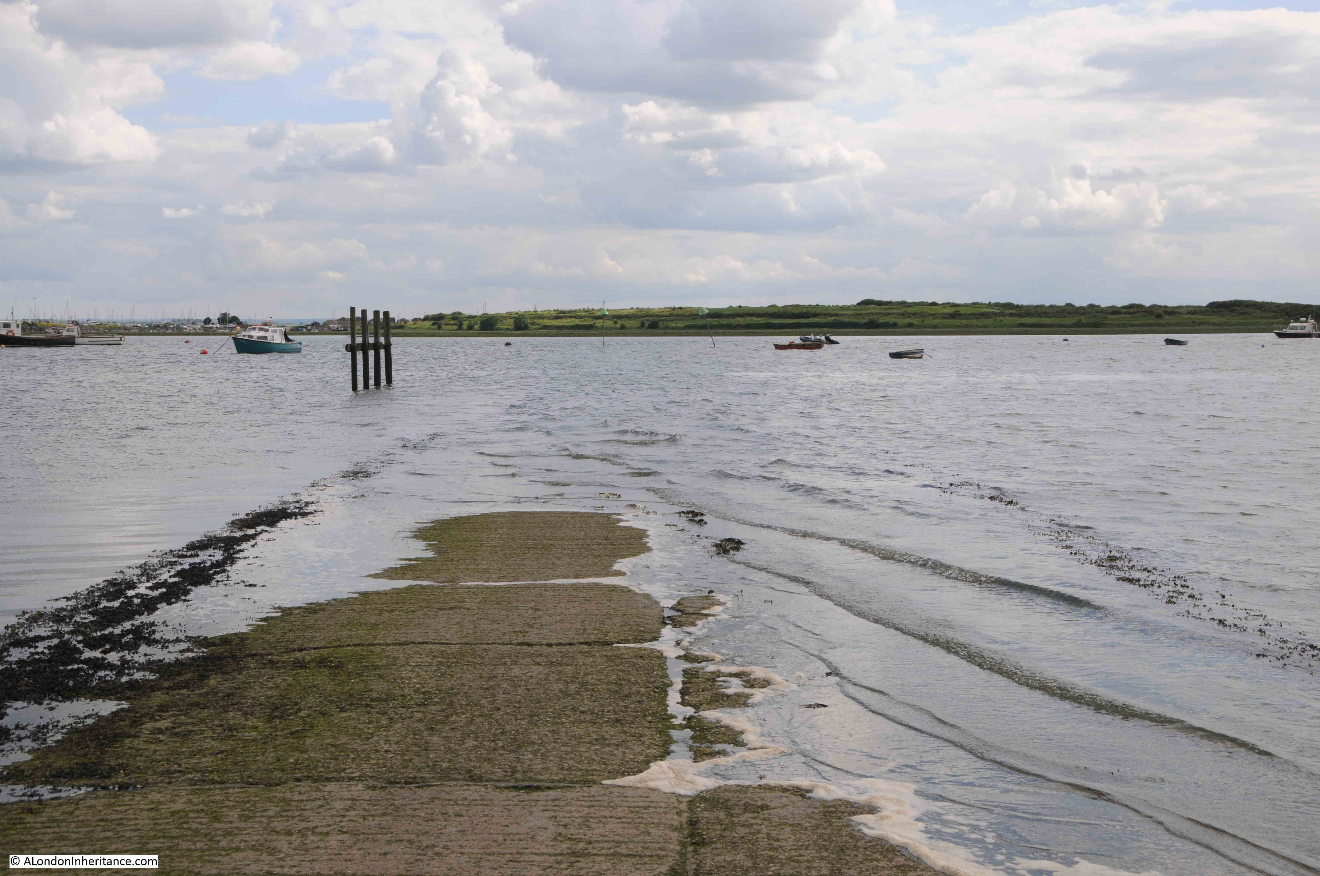
And I come to the dock which is shown on the maps, and is in the PLA listing. This is Bargehouse Causeway:

In the PLA listing, it is called “Old Barge House Drawdock”, and the listing states that there were “Stone setts on wooden piles”. The OS maps do not name the causeway, but show that a causeway extended out from the dock, however if this still exists, it was not visible due to the state of the tide during my visit.
The word Drawdock refers to a place where a boat could be drawn out from the river.
The sign on the pole states that there is no mooring and the causeway is not in use for personal water craft. The location of the pole probably makes the causeway difficult to use as it is placed in the middle of the approach to the landing place.

Although it is just Bargehouse Causeway today, the use of the name Old Barge House Drawdock in the PLA listing provides a better indication of its age.
The causeway is the site of one of the first ferries between what is now North Woolwich, and the town of Woolwich, between what was Essex and Kent, and was first mentioned in 1308.
There are very few mentions of the ferry up until the end of the 18th century, and in the following decades the ferry at Old Barge House Drawdock seems to have been a very active place.
It was in use for foot passengers crossing the Thames, as well as farmers taking their produce to market, with a frequent route being Kent farmers taking cattle to market in Romford.
The name of the draw dock seems to have come from the home of one of the early operators of the ferry, who had dragged up an old barge from the river, and lived in the barge above the shoreline.
In the OS maps shown earlier in the post, you can see a building with the PH for Public House, and the pub was on the site of the old barge, and took the name of the Old Barge Inn.
During much of the 19th century, the ferry was very busy, and the Army also introduced their own ferry between Woolwich and Old Barge House Drawdock.
Such was the popularity of the crossing, one of the operators of the ferry embarked on the following works, reported in the Kentish Mercury on the 9th of May, 1840:
“WOOLWICH FERRY – Mr. Thomas Howe, proprietor of the Old Barge House, Woolwich Ferry, has nearly completed the embankment of the Thames, which he commenced during the latter end of last summer. The esplanade now formed is about one thousand feet in length, with a depth of one hundred and fifty, and is raised to the height of twenty feet above high-water mark.
The whole level has been laid down with grass turf, and surrounded by a neat railing, and when completed will form one of the most pleasing promenades on the banks of the Thames, commanding, as it does a perfect view of Woolwich, with its Dock-yard and Arsenal, together with Plumstead, Shooter’s Hill, and the delightful scenery of Kent.
Upwards of one thousand barge-loads of rubbish have been employed in forming this embankment. The traffic between the two counties has increased about one hundred per cent since the improvement on this ferry commenced. The thousands who pass the ‘Old Barge House’ will scarcely observe that this favourite spot in in the county of Kent, notwithstanding it is situated on the Essex shore.”
Strange to think whilst standing at the dock, that this was once described as one of the most pleasing promenades on the banks of the Thames, however it was rare for a large area of space, with good transport connections, and green space, to be found along the river. The Victoria Embankment had yet to be built, and much of the river, on both north and south banks was industrialised, so I can imagine that this place in North Woolwich was a very pleasant place to visit.
What killed off the ferry from the Old Barge House Drawdock, was the opening in 1889 of the Woolwich Free Ferry. A ferry where you had to pay to cross the river could not compete with a free ferry which was a very short distance away.
The view towards the east, along the Thames from the concrete ramp at Old Barge House Causeway:

Walking up from the Barge House Causeway / Drawdock, requires walking up a ramp, and then steps or a longer ramp to get down to Barge House Road, which leads up to Albert Road.
The road is obviously named after the pub (which stood to the left of the following photo), and the old drawdock, and the barge used at some point as a home by an operator of the ferry:

This was such an interesting, short walk.
Royal Victoria Gardens is a lovely open space along the river, which owes its existence to the Royal Pavilion Pleasure Gardens and the associated hotel, once at the western end of the gardens, and the promenade built by the owner of the Barge House pub at the eastern end of the gardens.
These were both places that were built due to the availability of adjacent transport routes, and seem to have been places that attracted thousands of visitors to North Woolwich in the decades around the middle of the 19th century.
The need for the ramp and river walkway walls to built up, can be seen from the above photo, where the low lying area of North Woolwich is today still protected from high tides by large concrete walls and ramps.
It would be interesting to find out if any of the “one thousand barge-loads of rubbish” that were used to formed the embankment in 1840 is still there, as I suspect it would offer an interesting look into mid-19th century life.
I hope to be offering some walks around North Woolwich and the Royal Docks later in the year – if I can get organised in time, as this is a really interesting part of east London to explore.