Tag Archives: South Bank

A 1943 View Of A Redeveloped London

In 1943, although the end of the last war was still two years away,  the thoughts of the London County Council were focussed on the post war reconstruction of the city.

London had yet to suffer the barrage of V1 and V2 weapons, but in 1943 the London County Council published the County of London Plan, a far reaching set of proposals for the post-war development of the city.

I find the many plans for London that have been published fascinating to read. They show the challenges of trying to forecast the needs of a city such as London for decades to come. They provide a snapshot of the city at the time, and they demonstrate that time after time, development of London has reverted to ad-hoc rather than grandiose, city wide schemes.

In the forward to the plan, Lord Latham the Leader of the London County Council wrote:

“This is a plan for London. A plan for one of the greatest cities the world has ever known; for the capital of an Empire; for the meeting place of a Commonwealth of Nations. Those who study the Plan may be critical, but they cannot be indifferent.

Our London has much that is lovely and gracious. I do not know that any city can rival its parks and gardens, its squares and terraces. but year by year as the nineteenth and twentieth centuries grew more and more absorbed in first gaining and then holding material prosperity, these spaces were over-laid, and a tide of mean, ugly, unplanned building rose in every London borough and flooded outward over the fields of Middlesex, Surrey, Essex, Kent.

Athens was the glory of Greece, Rome the great capital of a great Empire, a magnet to all travellers. Paris holds the hearts of civilised people all over the world. Russia is passionately proud of Moscow and Leningrad; but the name we have for London is the Great Wen.

It need not be so. Had our seventeenth century forefathers had the faith to follow Wren, not just the history of London, but perhaps the history of the world might have been different.

Faith, however was wanting. It must not be wanting again – no more in our civic, than in our national life. We can have the London we want; the London that people will come from the four corners of the world to see; if only we determine that we will have it; and that no weakness or indifference shall prevent it.”

The 1943 plan provides plenty of detailed analysis of London at the time, with some graphical presentation using techniques I have not seen in any earlier London planning documents.

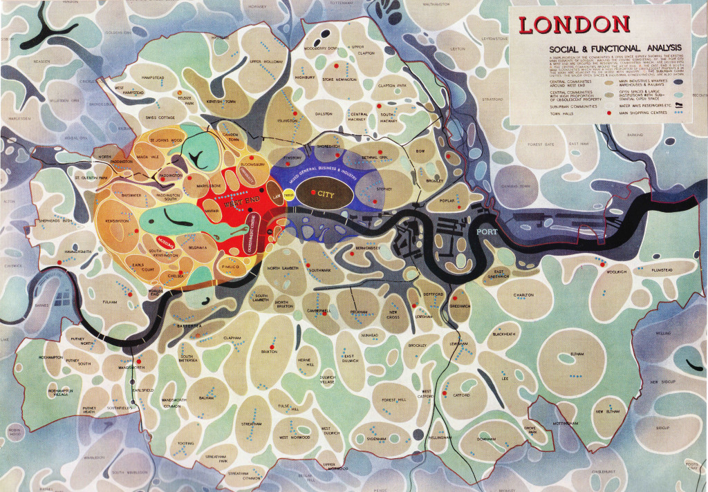
The following diagram from the report provides a Social and Functional Analysis of London. This divides London into individual communities, identifies the main functions of the central areas, shows town halls, man shopping centres and open spaces.

The City is surrounded by an area of “Mixed General Business and Industry”. Press (Fleet Street) and Law (the Royal Courts of Justice) provide the main interface between the City and the West End, which also contains the University and Government areas of the city.

The darker brown communities are those with a higher proportion of obsolescent properties. (click on any of the following maps to enlarge)

Social and Functional Map 1

The plan placed considerable importance on community structure within London:

“The social group structure of London is of the utmost importance in the life of the capital. Community grouping helps in no small measure towards the inculcation of local pride, it facilitates control and organisation, and is the means of resolving what would otherwise be interminable aggregations of housing. London is too big to be regarded as a single unit. If approached in this way its problems appear overwhelming and almost insoluble.

The proposal is to emphasise the identity of the existing communities, to increase their degree of segregation, and where necessary to reorganise them as separate and definite entities. The aim would be to provide each community with its own schools, public buildings, shops, open spaces etc. At the same time care would be taken to ensure segregation of the communities was not taken far enough to endanger the sense of interdependence on the adjoining communities or on London as a whole.”

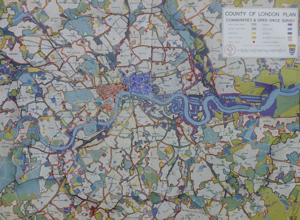
The following map shows a more traditional view of the Communities and Open Spaces within the Greater London area.

Communities and Open Space 1

The plan identifies a number of issues that divide communities, chief among them the way that railways, mainly on the south of the river have divided local communities with railway viaducts acting as a wall between parts of the same community.

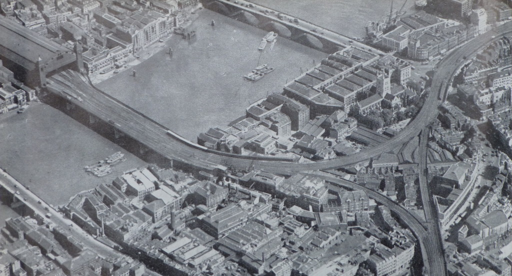
The plan used the following photo of the railway viaducts on the approach to Cannon Street Station and down to Waterloo to illustrate the impact. The report, as with a number of other proposals for the post war development of London, placed considerable importance on moving the over ground railways into tunnels to remove viaducts, bring communities together and to remove rail bridges, such as the one shown leading into Cannon Street Station, from across the Thames.
The Southbank 2

The first sentence in the section on Roads is remarkable, remember this was written in 1943, not 2015:

“The need for improved traffic facilities in and around London has become so acute, that unless drastic measures are taken to relieve a large number of the thoroughfares, crossings and junctions of their present congestion, there will be a grave danger that the whole traffic system, will, before long, be slowed to an intolerable degree.”

The plan also emphasises the dangers resulting from traffic on London roads with in 1937 a total of 57,718 accidents in the Greater London area that involved personal injury.

At the time of planning, the ratio of cars to population was one to twenty two. The plan expects a considerable increase in car usage after the war, stating that the war has “made a vast number of people for the first time mechanically minded, and has given a great impetus to the production of motor vehicles.”

Parking this number of cars was also expected to be a problem. The plan includes the provision of underground car parks and that legislation should be passed that enforces the provision of car parking facilities for all buildings of a certain size.

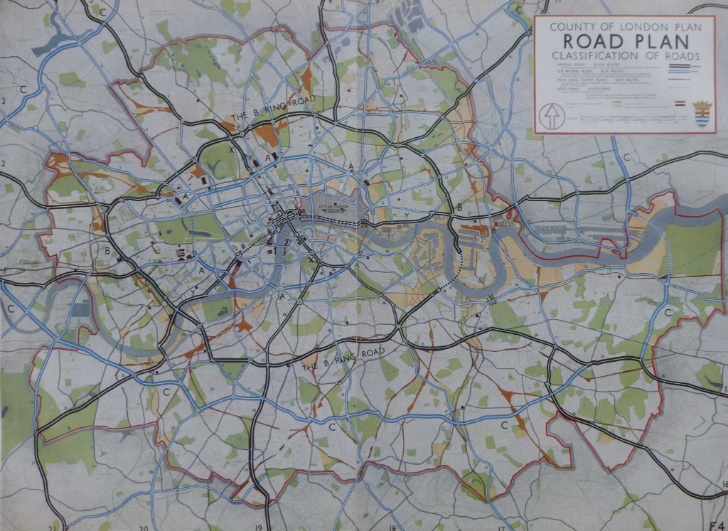
A new ring road was planned for fast moving traffic.  This is shown as the B Ring Road in the following map. Circling the central area of London and with a tunnel under the Thames running from the Isle of Dogs to Deptford. Roads radiating out from the B Ring Road would allow traffic circulating around London to quickly leave to, or arrive from the rest of the country.

Road Plan 1

The plan also identifies the “cumulative effect of street furniture on the appearance of London and on the convenience of pedestrians and vehicular traffic is very considerable” and recommends the formation of a Panel to provide a degree of control over street furniture, with a preference for embellishing streets with tree-planting and green-swards. With the level of street furniture on the streets today, perhaps a Panel to control this would have been a good outcome.

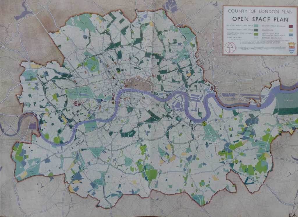
The provision of more open space was seen as a key component of the future development of London with the standardised provision of space for Londoners.

At the time the plan was written there was a considerable variation in the amount of open space available to Londoners in different boroughs, for example the inhabitants of Woolwich benefited from the availability of 6 acres per 1,000 inhabitants, whilst for those of Shoreditch the amount of open space available was 0.1 acres per 1,000 inhabitants.

The provision of 4 acres of open space for every 1,000 inhabitants across London was adopted as a key strategy for future development.

Examples of how open space could be made available to the public included the use of Holland Park, the grounds of the Hurlingham Club and the Bishops Palace Grounds in Fulham.

Indeed at Hurlingham, after the war, the London County Council made a compulsory purchase of the polo grounds to build the Hurlingham Park recreation grounds, along with the Sullivan Court flats and a school, leaving the Hurlingham Club with the 42 acres retained today.

The plan also states that “The difficulty of finding alternative housing accommodation for people displaced when open spaces are provided in built up areas, has been partly removed through the destruction of many houses by bombing.” I am not sure what the view of those who had lost their homes through bombing would have been, that there was a plan to replace their homes with open space.

The following Open Space Plan shows the proposed new public open space in dark green:

Open Space Plan 1

The 1943 plan presents a fascinating view of the industrialisation of London.

The East End of London and the London Docks were well known industrial areas, however every London borough had a significant amount of factories and industrial employment. The report includes a summary of industry for every London borough. I have shown a sample below to indicate the range of factory numbers, employment levels and types of industry across some of the London boroughs.

Borough Principal industries according to numbers employed Size of Factories Factory numbers in 1938 Factory employees in 1938
Bermondsey Food, engineering, and chemicals, including tanneries Each of the principal industries has a large number of factories 711 31,058
Bethnal Green Furniture and clothing Furniture factories very small, clothing small with a few large premises 1,746 15,945
Finsbury Clothing, printing and engineering, though appreciable numbers are employed in all other industries Mostly medium to small, though each industry has a number of large factories and the average size if bigger than in Bethnal Green, Shoreditch or Stepney 2,523 66,556
Islington Engineering, clothing, furniture and miscellaneous (principally builders’ yards, cardboard boxes and laundries) Mostly small, though engineering, furniture and miscellaneous each has a number of medium sized factories 1,998 35,649
Stepney Clothing, food (including breweries and tobacco) and engineering Mostly small (especially clothing) but each industry has a number of large factories 3,270 58,073
Westminster Clothing, printing and engineering, though appreciable numbers are employed in all other industries Mostly small (especially clothing), but each industry has several large factories 4,414 46,528

The plan identifies a trend of decentralisation which had already being happening for a number of decades with the gradual migration of industry from central to outer London and also identifies the improvement in transport facilities as enabling industry to move away from the main residential areas.

Even in 1943 the report identifies the importance of the new industrial estates at Slough, Park Royal, along the Great West Road etc. as the future home for more of London’s industry.

What the plan does not identify is how the Docks would change over the coming decades. The expectation was that the London Docks would continue to provide a key role in both London and the Nation’s global trade.

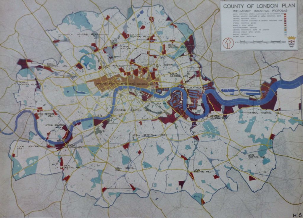
The following map shows the proposed approach for how industry would be located across the Greater London area. Note the concentration of industrial areas around the Docks and along the Thames.

Industrial Proposals 1

In addition to planning at the Greater London level, the 1943 report also focussed on a number of specific areas that had suffered extensive bomb damage and were therefore important redevelopment locations.

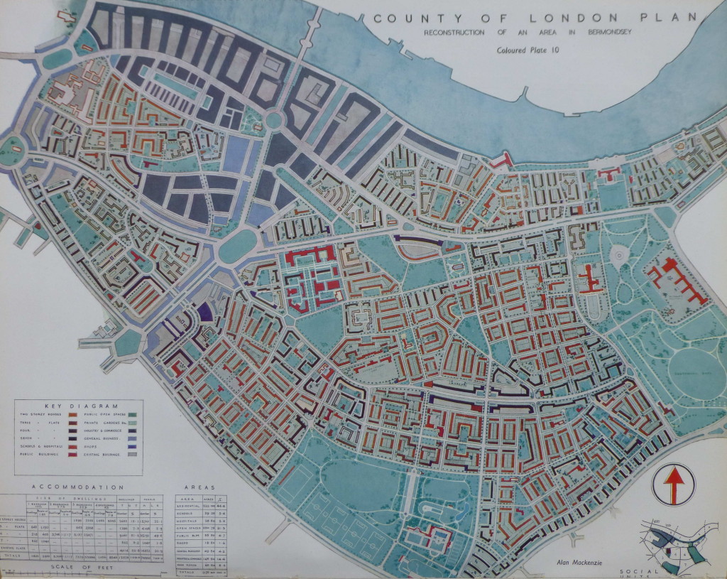
An example is the redevelopment of Bermondsey. The following plan shows the proposed post-war reconstruction of Bermondsey:

Bermondsey 1

The plan for Bermondsey illustrates how the 1943 plan proposed:

  • replacing the long runs of railway viaducts with underground rail tunnels thereby avoiding the way the viaducts divided communities
  • a considerable increase in the amount of public open space
  • wide through roads to carry traffic efficiently across London
  • reduced housing density

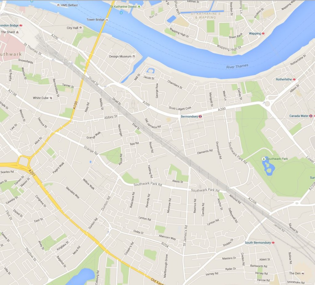
How far these plans were actually implemented after the war can be judged by comparison with the following 2015 map of Bermondsey. The railway viaducts still remain, cutting across the borough, and the street layout remains largely unchanged. Southward Park provides a large amount of open space, however there is not the amount proposed in 1943 and the large park planned to run adjacent to the Old Kent Road was not constructed.

New Bermondsey Map 1

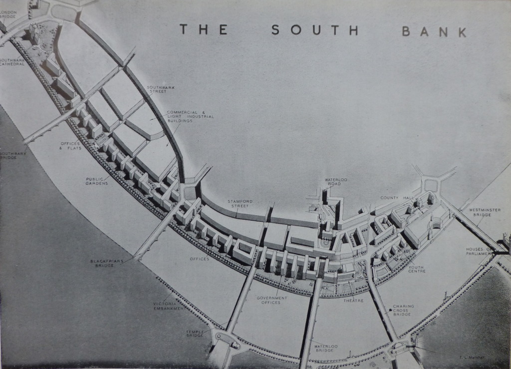
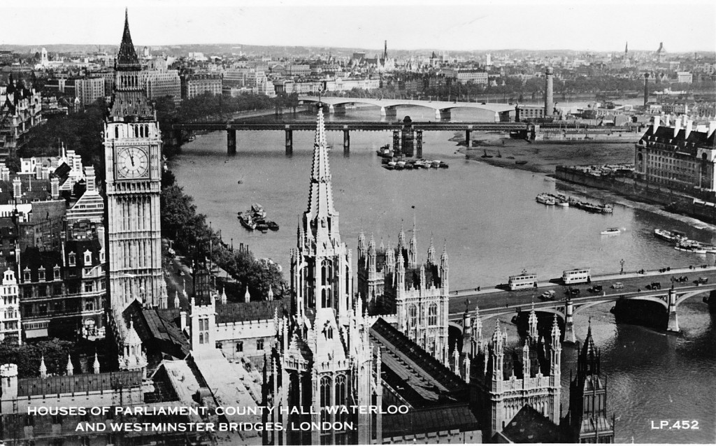
Another focus for significant redevelopment was the South Bank. Starting from Westminster Bridge and County Hall at the right of the following picture, the plans consisted of:

  • a Youth centre to the left of County Hall
  • a new road bridge across the Thames leading to Charing Cross to replace the rail bridge after the railways had been diverted underground
  • a Theatre between Charing Cross and Waterloo Bridges (which did get built in the form of the Royal Festival Hall)
  • Government offices running to…..
  • a new bridge – Temple Bridge – across the Thames from the South Bank to Temple Station, in exactly the same place as the proposed Garden Bridge
  • offices then running to Blackfriars Bridge
  • followed by office and flats leading up to a landscaped area around Southwark Cathedral
  • with public gardens running the length of the Thames embankment

The South Bank 1

When reading the plan I was really surprised to find that in 1943 there were proposals for a bridge across the river at Temple. Although this would have been more functional than the proposed Garden Bridge, it would still have blocked some of the view from Waterloo Bridge and the South Bank across to St. Paul’s and the City.

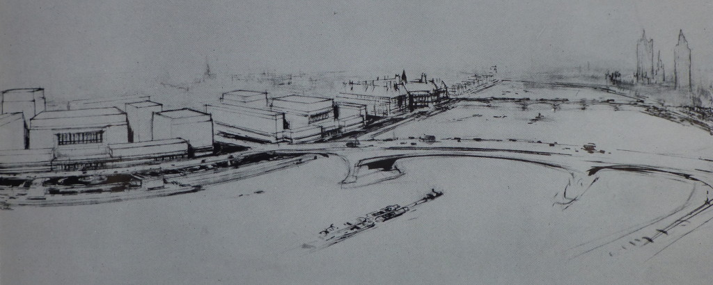
The following picture is an artist impression from the 1943 report of the proposed new Charing Cross road bridge:

Charing Cross Bridge 1

The 1943 report places considerable importance on the need for housing after the war, claiming that “Of the many aspects of London’s future in so far as replanning is concerned, that of housing must claim first attention.” and that “The provision of new housing accommodation will be a most urgent task to be tackled immediately after the war.” Some things do not change, although in 1943 the plans for housing in central London were very much the provision of affordable housing for Londoners rather than the endless development of luxury apartments we see today.

The 1943 plan proposes a comprehensive housing plan to address the need to improve the housing conditions for Londoners as well as providing the number needed.

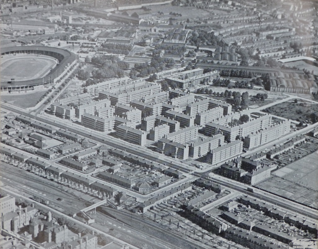
The following photo from the 1943 plan shows some of the building commenced prior to the war. This is the White City Housing Estate, Hammersmith. Construction started in 1936 and was suspended in 1939. The plan states that when work recommences, the estate will cover an area of 52 acres and comprise 49, 5 storey blocks with accommodation for 11,000 people.

The White City Stadium can be seen on the left of the photo. Completed in 1908 for the Summer Olympics of the same year, the stadium was demolished in 1985 following which the BBC occupied the site. The BBC are now gradually vacating the site so it will be interesting to see what happens with this significant site in the future. (There is plaque on one of the BBC White City buildings at the point of the finishing line of the 1908 track)

White City 1

The 1943 plan recommends the development of housing estates and uses the Roehampton Cottage Estate in Wandsworth as an example of the type of estate that should be built, including the preservation of trees which “adds greatly to the attractive lay-out”
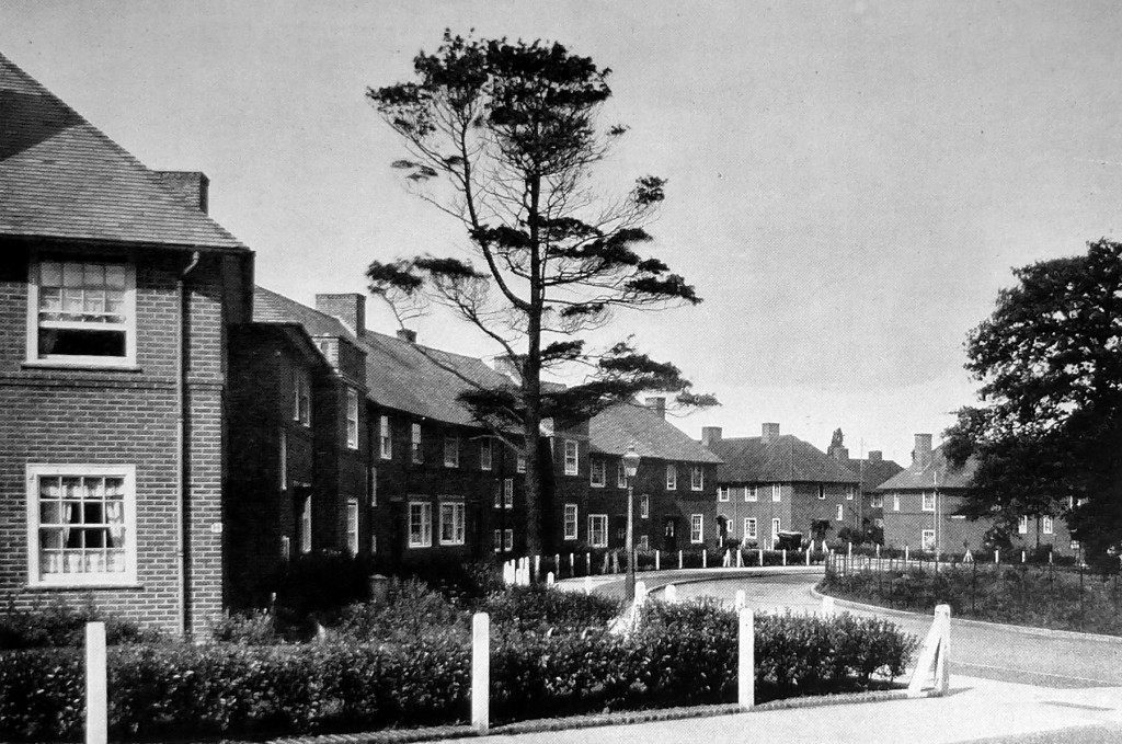
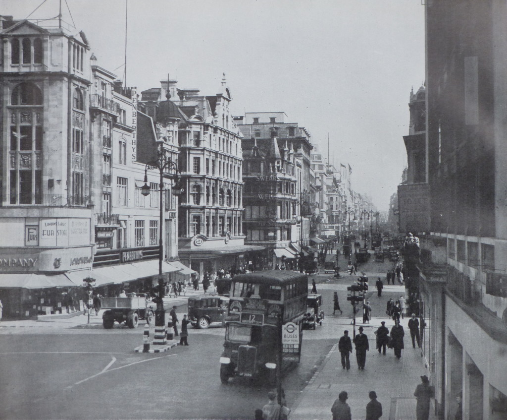
Roehampton 1The 1943 plan also makes recommendations for greater architectural control and uses the following view of Oxford Street as an example of “the chaos of individual and uncoordinated street development” 

Architectural Control 1

The plan recommends “that Panels of architects and planners might be set up to assist the planning authority in the application of a control for street design, similar to those already in operation in other countries, notably in America and Scandinavia. Cornice and first floor levels, as well as the facing materials used, should be more strictly controlled so as to give a sense of continuity and orderliness to the street”. 

The 1943 plan is a fascinating read, not only covering London at the time, but also how London could be today if these plans had of been adopted in full. I have only been able to scratch the surface of the report in this week’s post.

Reading the plan it is clear that some issues do not change, for example housing and traffic congestion.

The plan also highlights the difficulty in planning for the future. There is only a very limited reference to “Aerodromes”, beginning with “All the portents indicate that, after the war, there will be a very considerable expansion in air transport for passengers and, perhaps, for freight. Any plan for the future of London must have close regard for these eventualities.”

The plan does seem to rule out the construction of a large airport within the central London area as this would be “inimical to the interests and comfort of large sections of the population to embark on a scheme of this kind” The post war development of Heathrow was not considered in 1943.

In many ways I am pleased that many of the plans for the large scale redevelopment proposed in the 1943 plan did not take place. As with Wren’s plans for the City after the Great Fire, London tends to avoid large scale planning and seems to evolve in a haphazard manner which contributes much to the attraction of the city, although I feel that this is now under threat with the rows of identical towers that seem to be London’s future.

alondoninheritance.com


A Walk Round The Shell Centre Viewing Gallery

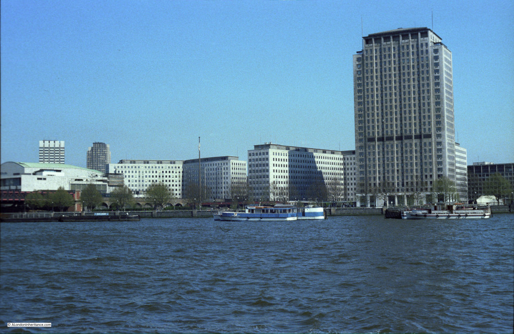
Shell Centre is an office complex on the Southbank, located between Hungerford Bridge and the old London County Council building. The most obvious part of the complex is the 26 storey tower.

Designed by Sir Howard Robertson and built between 1957 and 1962 for the Royal Dutch Shell group of oil companies, the office complex set new standards for staff facilities and building automation. Originally two main blocks, one either side of Hungerford Bridge, the “downstream” building to the east of Hungerford Bridge was sold during the 1990’s and converted to apartments.

Although large buildings above ground, there is a significant part of the complex below ground with a large swimming pool, theatre and bar being among the facilities for the original 5,000 staff to enjoy. Two underground tunnels connected the upstream and downstream buildings, running underneath the rail arches leading to Hungerford Bridge and being just above the underground train tunnels running north from Waterloo.

The building also had a tunnel out to the Thames so that river water could be used for cooling.

The “upstream” building to the west of Hungerford Bridge has a “U” shape set of 10 storey offices with the 26 storey, 351 foot tower block being the most obvious feature of the complex.

Shell has temporarily moved out of the complex and there is a proposed redevelopment of the site that will significantly change this part of the Southbank, more on this at the end of this post.

Long before the Shard and the Sky Garden at 20 Fenchurch Street, one of the innovations for the time was that the tower had a public viewing gallery. This was when there were very few tall buildings across London and certainly nothing built or planned in this part of the city. The viewing gallery provided almost continuous all round views of London.

The viewing gallery closed not that long after opening. I was told this was because that sadly there had been a suicide (although I have no verification of this). I was able to visit the viewing gallery in 1980 and took the following photos which show a very different London skyline to that of today. It always surprises me that it was not that long ago that there were very few tall buildings across London.

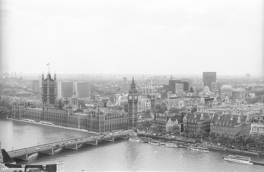
We will start with the view across to the Houses of Parliament and walk round the viewing gallery.

This was long before the construction of the London Eye which would now be the main feature of this view:

Shell Centre Viewing Gallery 3

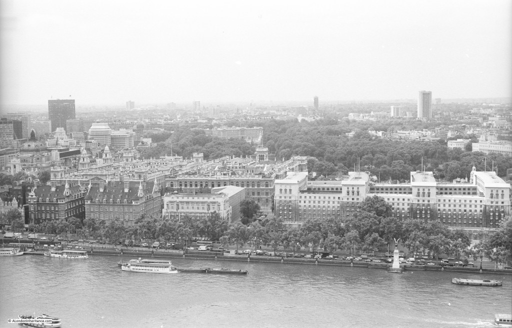
Moving further to the right we can look straight across the river. The large building to the right are the offices of the Ministry of Defence. Buckingham Palace is to the left of centre:

Shell Centre Viewing Gallery 15

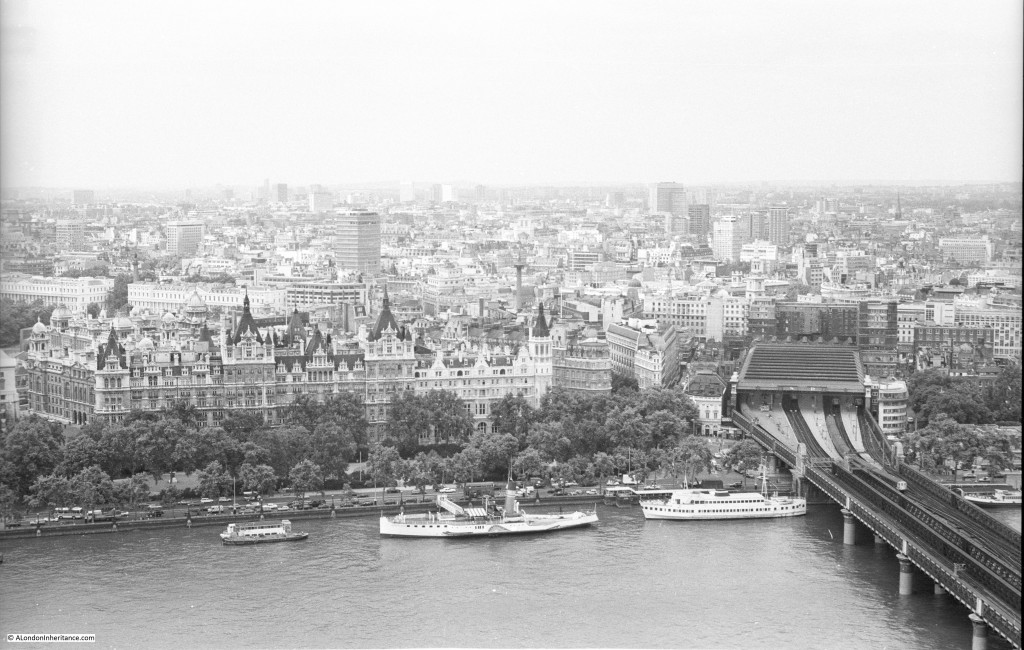
And further to the right, this is the original Charing Cross Station at the end of Hungerford Railway Bridge. In the years after this photo was taken, in common with many other main London stations, office buildings were constructed on top of the station. This was also before the Golden Jubilee foot bridges were added to either side of Hungerford Railway Bridge. At the time the photo was taken there was a single, relatively narrow foot bridge on the east side of the bridge.

Shell Centre Viewing Gallery 4

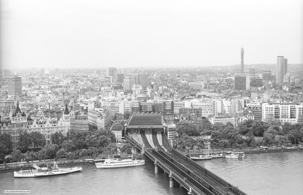
Looking directly onto Charing Cross Station with the Post Office Tower in the background and Centre Point to the right:

Shell Centre Viewing Gallery 2

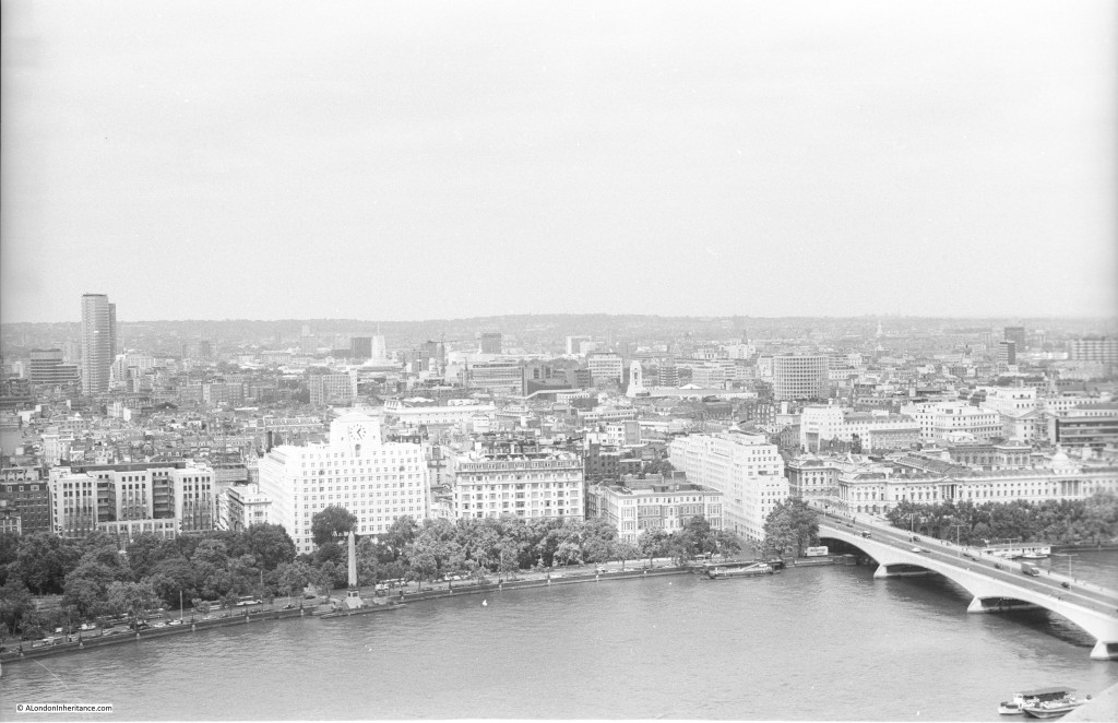
Further to the right, the building left of centre is Shell-Mex House. This was occupied by the UK operating company of Shell. To the right is Waterloo Bridge.

Shell Centre Viewing Gallery 14

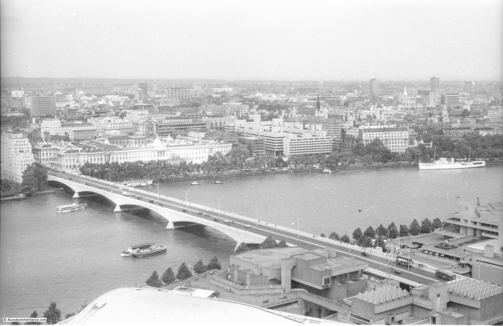
And further to the right with the full width of Waterloo Bridge:

Shell Centre Viewing Gallery 13

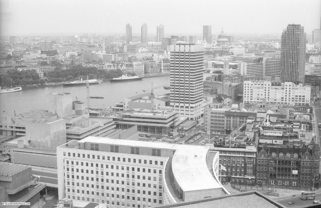
We are now starting to look over towards the City of London, St. Paul’s Cathedral can be seen to the upper right of centre and the three towers of the Barbican to the left.

The L shaped building in the lower foreground is the downstream building of the Shell Centre complex, and just above this building is the tower that was for London Weekend Television. The base of this tower still consists of TV studios, one of the few buildings that have had the same function over the last 35 years.

To the right of this is Kings Reach Tower, occupied at the time by IPC Magazines, publishers of magazines ranging from Loaded to Country Life. IPC Magazines vacated this tower block some years ago and it is now in the process of being converted into, yes you have probably guessed, more apartments. The height of the building is being raised with additional floors being constructed in top.

Shell Centre Viewing Gallery 7

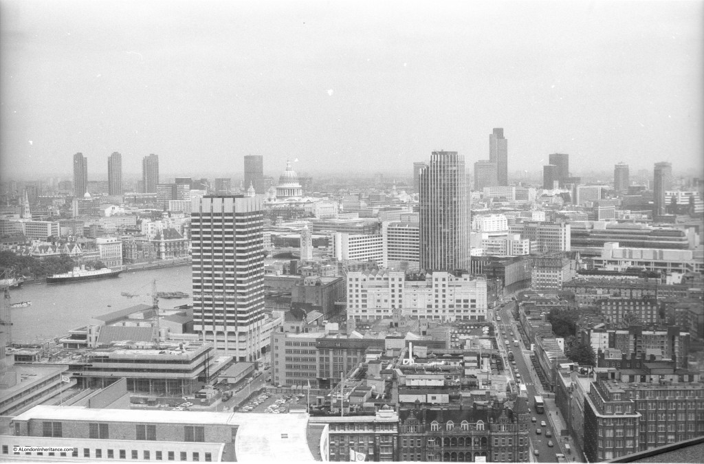
And slightly further to the right, the tower in the distance was at the time the tallest office block in the City of London, the recently completed NatWest Tower, built for the NatWest Bank, now renamed as Tower 42.

Shell Centre Viewing Gallery 1

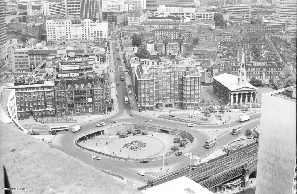
This photo is looking down onto the roundabout at the southern end of Waterloo Bridge. The large space in the centre of the roundabout is now occupied by an IMAX Cinema. The church to the right is St. John’s, Waterloo. The church was built between 1822 and 1824 and due to the marshy land had to be built on piles.  I was told at the time that one of the reasons for so much space below ground level at Shell Centre was also due to the marshy ground and the need to keep the overall weight on the site equal. Excavating below ground level to remove sufficient weight of earth equal to the weight of building on top. No idea if this is true, but it does seem plausible.

Shell Centre Viewing Gallery 5

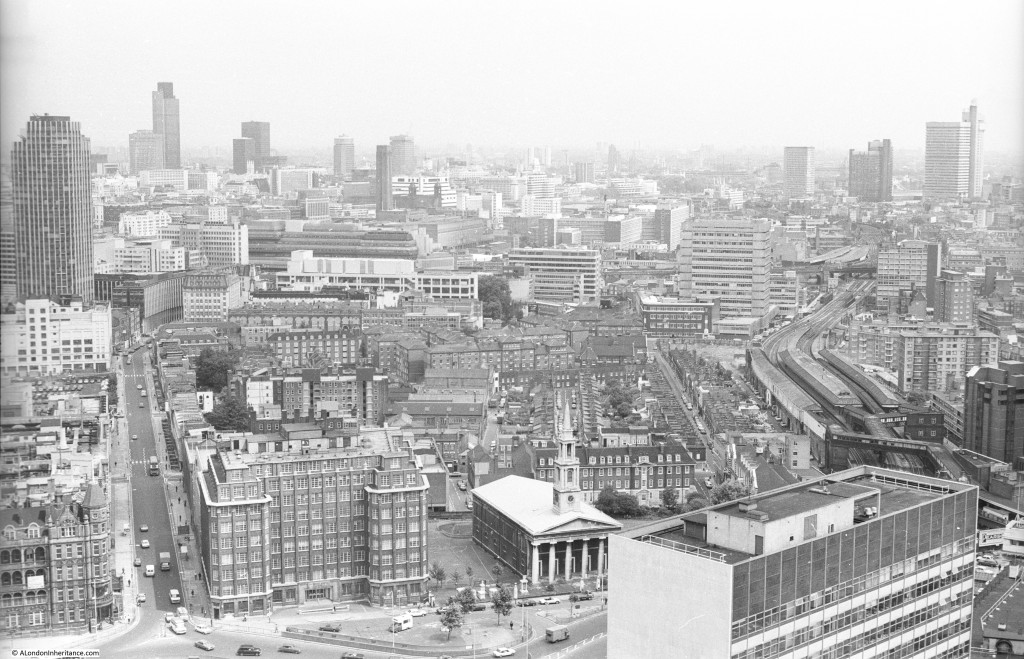
This photo is looking straight across to the City and Southwark. There is nothing of any height in the far distance. The buildings of Canary Wharf would now be very visible in the distance.

Shell Centre Viewing Gallery 9

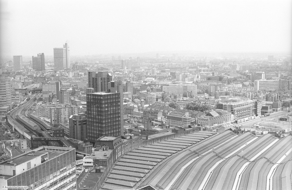
Continuing to move to the right, this is looking over south-east London with the roof of Waterloo Station occupying the bottom right corner of the photo.

Shell Centre Viewing Gallery 8

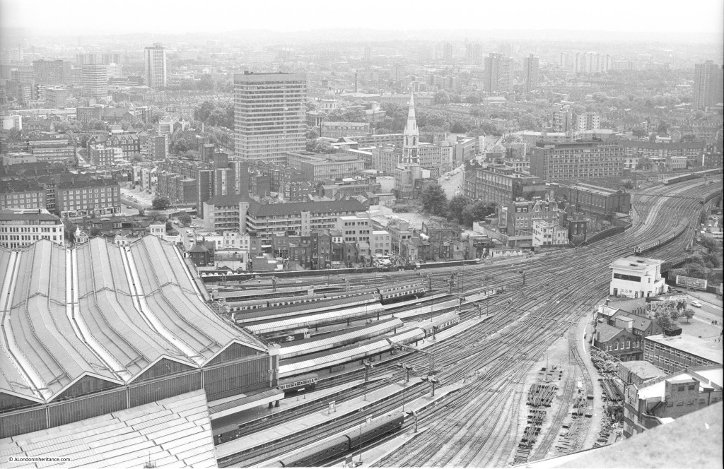
And round to the right again looking over south London with the extensive network of tracks leading into Waterloo Station. The lower section of tracks at the bottom part of the photo would soon be converted to the London terminus of Eurostar prior to the completion of the HS1 rail route which transferred Eurostar trains into St. Pancras.

Shell Centre Viewing Gallery 11

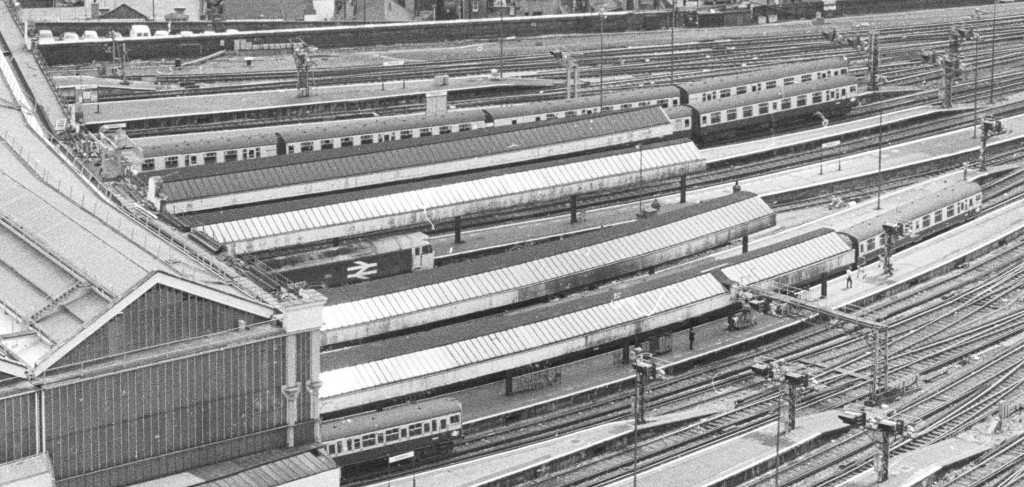
Detail from the above photo showing British Rail rolling stock prior to privatisation of the rail network:

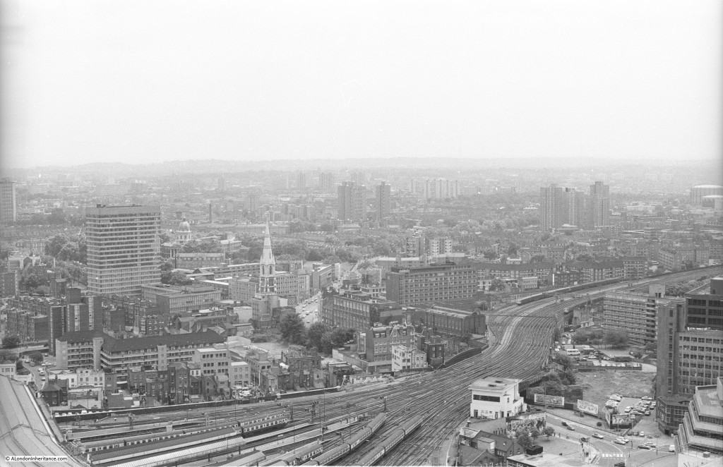
Shell Centre Viewing Gallery 18And a final view over to south west London. This was as far as the viewing gallery would allow, the gallery did not run along the western side of the tower:

Shell Centre Viewing Gallery 12

I cannot remember why I was using Black and White film when I took these photos from the viewing gallery. Shortly after taking the above, I took the following photo in colour showing Shell Centre from the north bank of the Thames. The north facing part of the viewing gallery can be clearly seen at the very top.

Shell Centre Viewing Gallery 17

The building is one of the few immediate post war developments that works well. If the proposed redevelopment of the site gets approval, it will be very different. The plans propose the demolition of the “U” shaped 10 storey office block at the base of the tower, and a whole new cluster of towers built around the original tower.

To see the proposed development, look here.

It was quite a surprise to see how much this area will change, and in my view, the close proximity of towers of very different materials and design to the original tower just does not look right.

It was fascinating to look back on these photos of the London skyline from 1980. It looks very different now, and the almost continuous development of tower blocks look set to continue transforming the skyline for many years to come, although unlike the original Shell Centre complex, with almost identical glass and steel towers that are removing so much of the local character of London.

alondoninheritance.com

The Royal Festival Hall – Dramatic Effects Of Space And Vista

I recently scanned some of my father’s photos which included the last photos he took in the early 1950s of the Royal Festival Hall. These photos show the area soon after the closure of the Festival of Britain when much of the infrastructure for the Festival was still in place.

At the end of this post I have put together a time sequence of photos of the site from 1947 through to 2015 showing the original site, during construction and photos taken in the early 1980s and 2015.

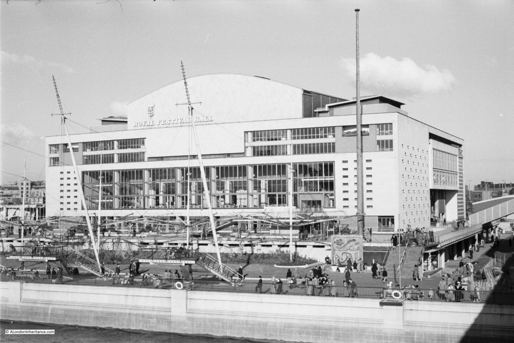
But first, the recently scanned photos, the first is of the Royal Festival Hall taken soon after closure of the Festival of Britain exhibition, from the footbridge alongside the Hungerford Railway Bridge.

Festival H4

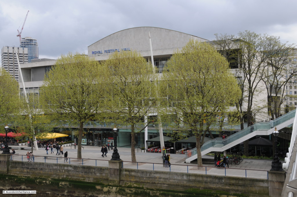
And from the same location in April 2015:

Festival H6

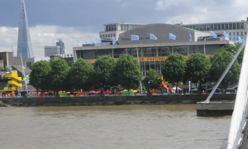
The overall shape of the Royal Festival Hall is exactly as it was when first built, however there have been a number of cosmetic changes to the front with the middle tier window line now stretching across the full front of the hall and changes to the top tier with a balcony now between the glass and the front of the hall.

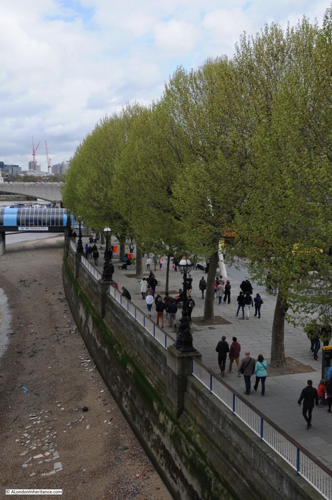
I planned to take the 2015 photo before the trees had come into leaf as when the leaves are fully grown the trees considerably obstruct the view of the hall. I was not early enough!

Please do not get me wrong, we do not plant enough trees, within the city and across the country, however there are some places where trees are in the wrong position. The Royal Festival Hall is, in my view, one of the very few buildings constructed soon after the last war that works well architecturally and is in the right location. The Royal Festival Hall was always designed to be seen from and across the River Thames and to provide views along to the City.

The trees in front of the building considerably obscure the building from the walkway across Hungerford Bridge and from the north bank of the Thames.

As the original Festival Guide stated:

“The Royal Festival Hall can claim to be a work of art in itself. The superb dramatic effects of space and vista, within the building and beyond it to the river and the city, are things which the visitor will discover for himself.”

Note also how in the original photo the Royal Festival Hall did not have any buildings in the background to detract from the view of the hall. A very different situation in 2015. To the right of the hall is the building that was the downstream building of Shell Centre, but has now been converted from offices to apartments. To the left is the Kent House Tower above the London TV Studios and behind that with the crane on the top is the South Bank Tower, again another building being converted from offices to apartments.

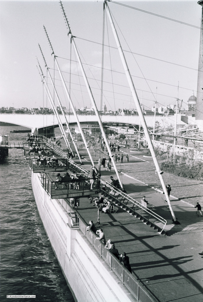
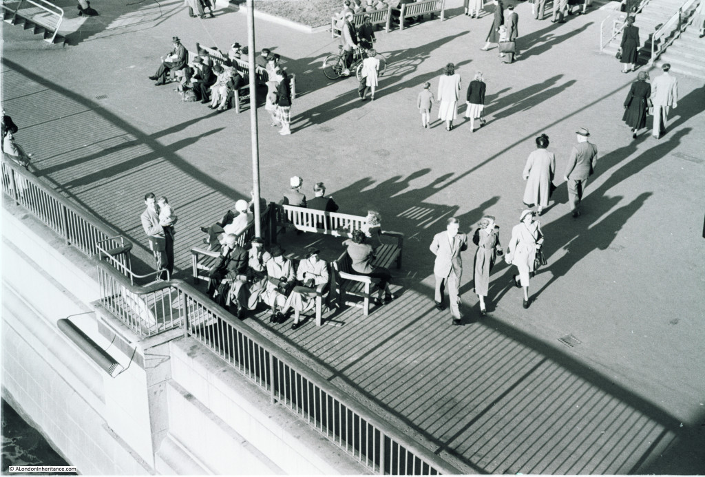
Walking a short distance further along the Hungerford footbridge, we can take a look down at the walkway in front of the Royal Festival Hall:

Festival H3

The poles are part of the decoration from the Festival of Britain. The photo also shows the observation platforms which I have heard of, but not seen photos of until scanning these negatives. There were six of these raised platforms extending just over the river wall and must have been a fantastic place to sit and view the surroundings.

At the far right of the photo is the Shot Tower, to the left can just be seen the walkway to the river pier, and in the distance is an excellent view over towards St. Paul’s Cathedral.

The view is very different in 2015:

Festival H7

The observation platforms are unfortunately long gone, and later replicas of the poles that can be seen in the original photo are just visible, however the view is considerably obstructed by the trees. Again, an example of why I would argue that this area of the Southbank is the wrong place for trees and their removal would open up both the view of the Royal Festival Hall and the views along the river and to the city.

The guide-book for the Festival of Britain shows the area in front of the Royal Festival Hall including the six observation platforms:

Festival H9

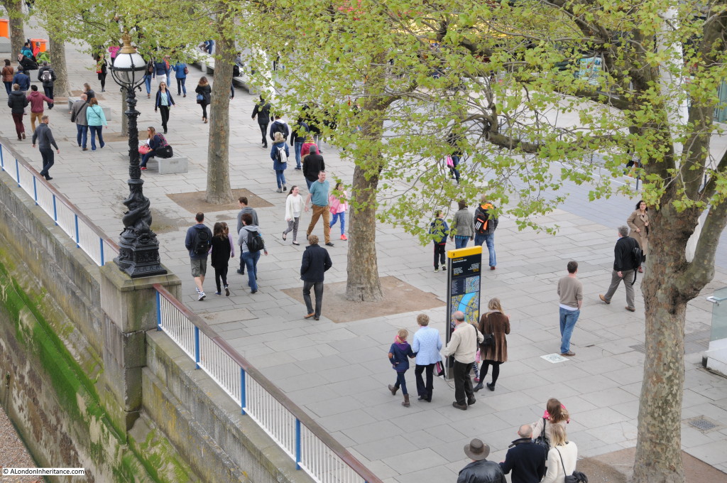
Walking almost to the end of the footbridge, we can look down and watch those out for a walk along the Southbank:

Festival H2

And the same location in 2015:

Festival H8

And a final view across to the Royal Festival Hall, with the Shot Tower on the left:

Festival H1

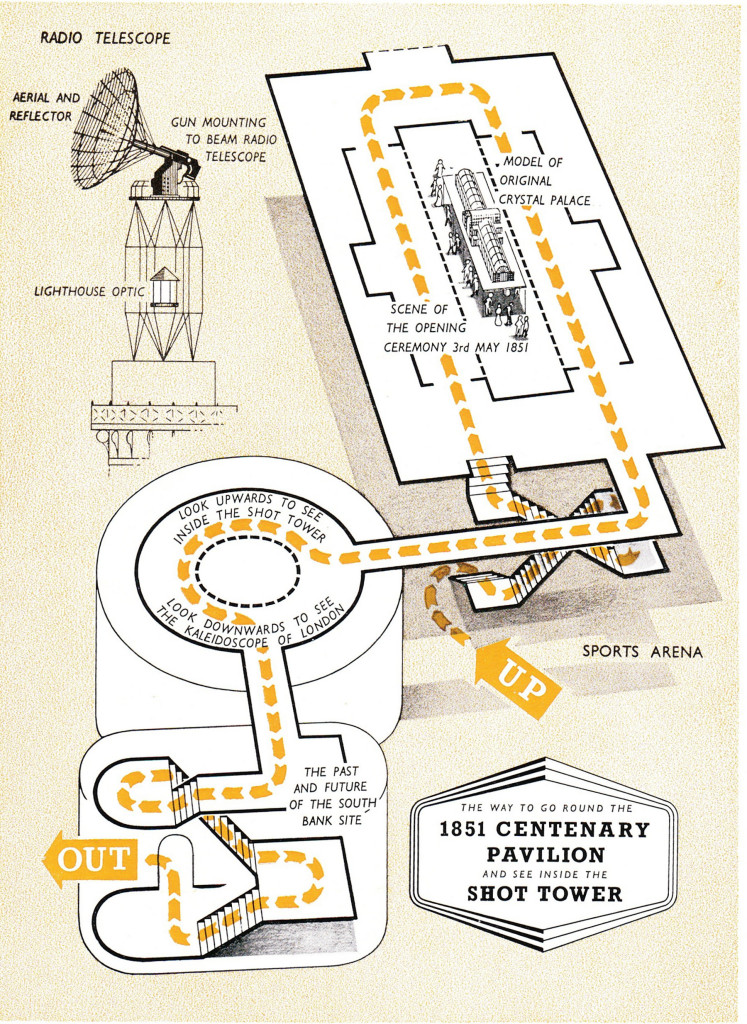
During the Festival, the Shot Tower had a Radio Telescope aerial mounted on the top. I had always assumed this was for decoration only, however the Festival Guide explains that it was a fully working system that would bounce radio signals off the moon, allowing visitors to see the time delay between the transmitted and reflected signal. The aerial system was mounted on a redundant gun mounting which could be moved to allow the aerial to track the moon.

From the Festival Guide Book:

“The Tower has been one of the landmarks of London since it was built-in 1826. It remains the only old building on the site, to serve as a beacon for the Festival. It is a beacon in two senses: it is a modern lighthouse with a double flashing beam welcoming visitors as far as 45 miles away when the weather is clear; it is a radio beacon directing radio signals to the moon and beyond into space.

The lighthouse mounted at the top will flash from sunset to Exhibition closing time. It has a power of 3 million candles. It is of the most modern all-electric design and so takes up far less space than the older types which needed weighty lenses to intensify the beam. The light itself comes from a lamp of three thousand watts; an automatic device ensures that a second lamp can swing into position should it fail. This lighthouse optic is the work of Chance Brothers Ltd., who made all the glass for the original Crystal Palace a hundred years ago.

The radio beam is above the lighthouse optic. The most obvious part of it is a large reflector which beams the signal from the aerial within it on to the moon. This is part of the radio telescope and is connected with the display in the Dome of Discovery by underground cable. In the Dome visitors can transmit signals to the moon and actually see them reflected back to the earth after about two and a half seconds.”

This was 64 years ago and I wonder if our public demonstration of science has progressed much since.

The following is from the Festival Guide and shows the detail of the top of the Shot Tower. As with the observation platforms, it would have been good if the Shot Tower could have been preserved as part of the Southbank’s history.

Festival H10

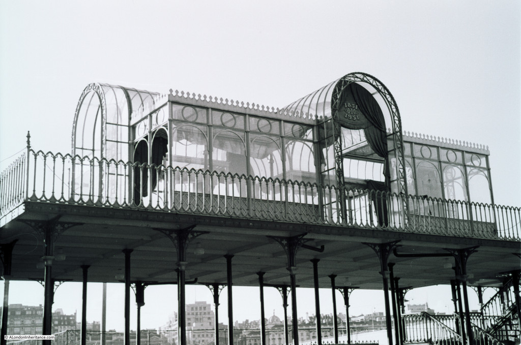
Also on the negatives were some photos of the following structure:

Festival H5

This was at the far eastern end of the Festival Hall site (Waterloo Bridge can just be seen at the lower right). The numbers on the central arch are the years 1851 and 1951.

1851 was the year of the Great Exhibition held in the “Crystal Palace” in Hyde Park. This structure looks to be a very rough approximation of the original Crystal Palace building. Both exhibitions had a very similar theme to demonstrate the country’s strength in industry and science.

I have featured this area of the Southbank in a number of posts to highlight different periods in the development of the site. I have brought the photos taken by my father and myself together in the following sequence to show how the site has changed from 1947 to 2015.

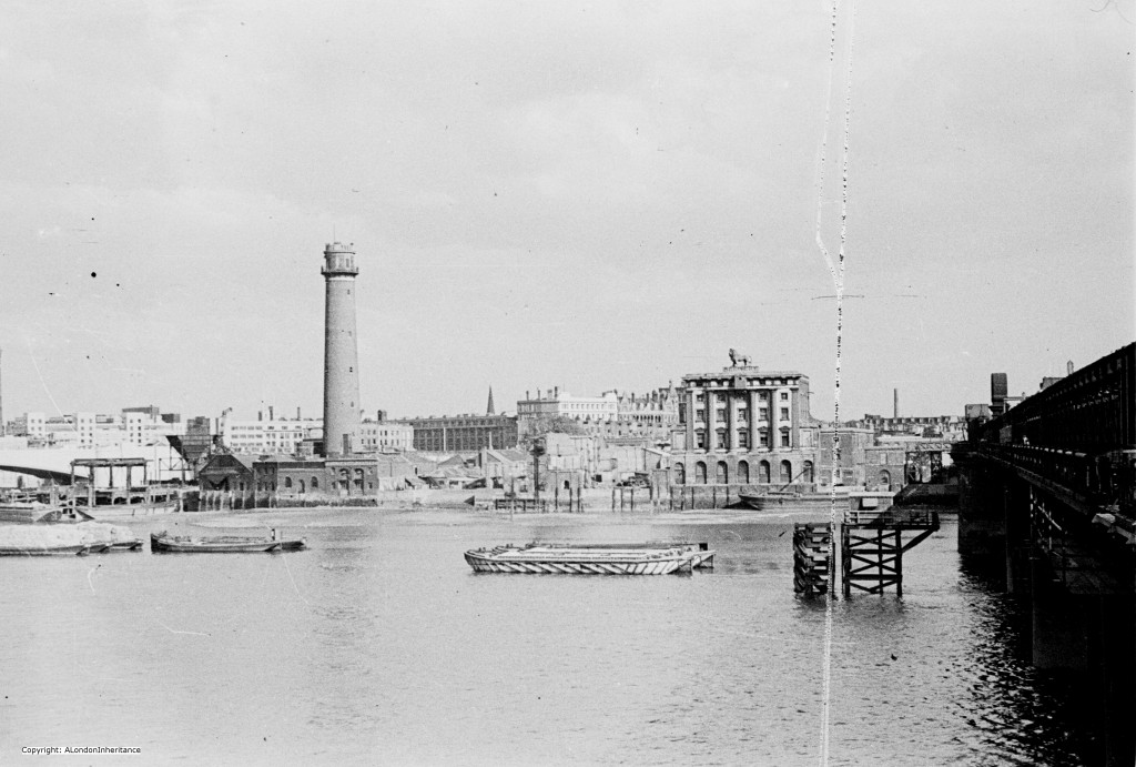
Starting in 1947, and the site still retains the original buildings with the Shot Tower on the left and Lion Brewery building to the right:

Festival 4

Construction starts. This is a panorama of several of my father’s photos to show the whole of the building site that would become the Royal Festival Hall:

Panorama

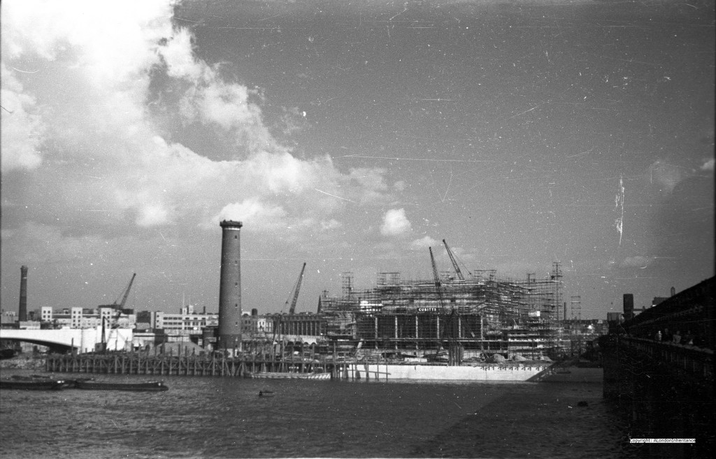
Construction is now well underway with cranes and scaffolding surrounding the building (compare this with the 1947 photo):

Festival 1

And repeating the photo from this week’s post, the completed Royal Festival Hall just after the Exhibition:

Festival H4

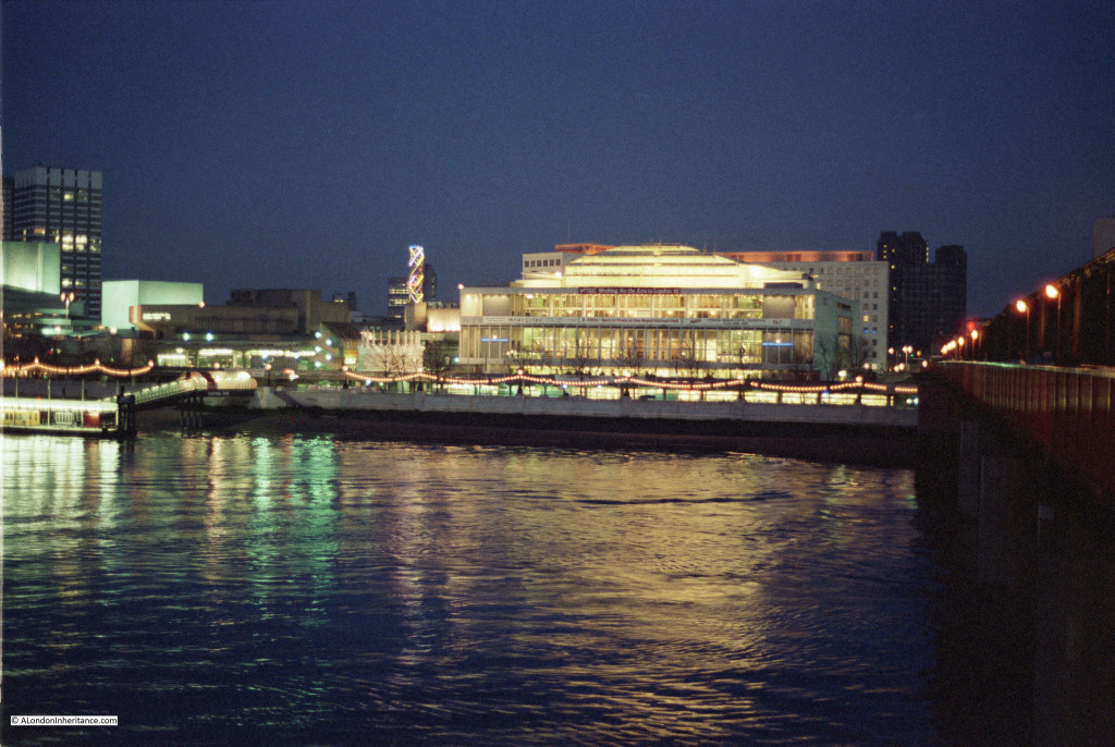
Now fast forward 30 years to the early 1980s and this is one of my photos of the Royal Festival Hall. Still no trees and the hall is an impressive site from the north bank of the Thames:

Festival H11

Summer 2014 and even from the height of the walkway along the side of Hungerford Bridge, the hall is hiding behind the trees:

trees

The guidebook to the Festival in the section on the Royal Festival Hall explains that it is a work of art in itself  and “the superb dramatic effects of space and vista, within the building and beyond it to the river and the city“. With the way that London is growing, the opportunity to appreciate space and vista at ground level is diminishing. It would be good if the area in front of the Royal Festival Hall could be opened up again to meet the original intentions of the architects.

You may also be interested in my other articles on this area:

The South Bank – Before the Festival of Britain and the Royal Festival Hall

The Royal Festival Hall – Before, During And After Construction

alondoninheritance.com

A Wartime Temporary Bridge And County Hall

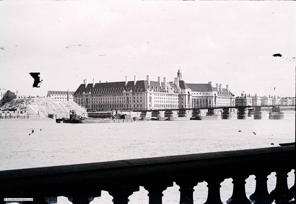
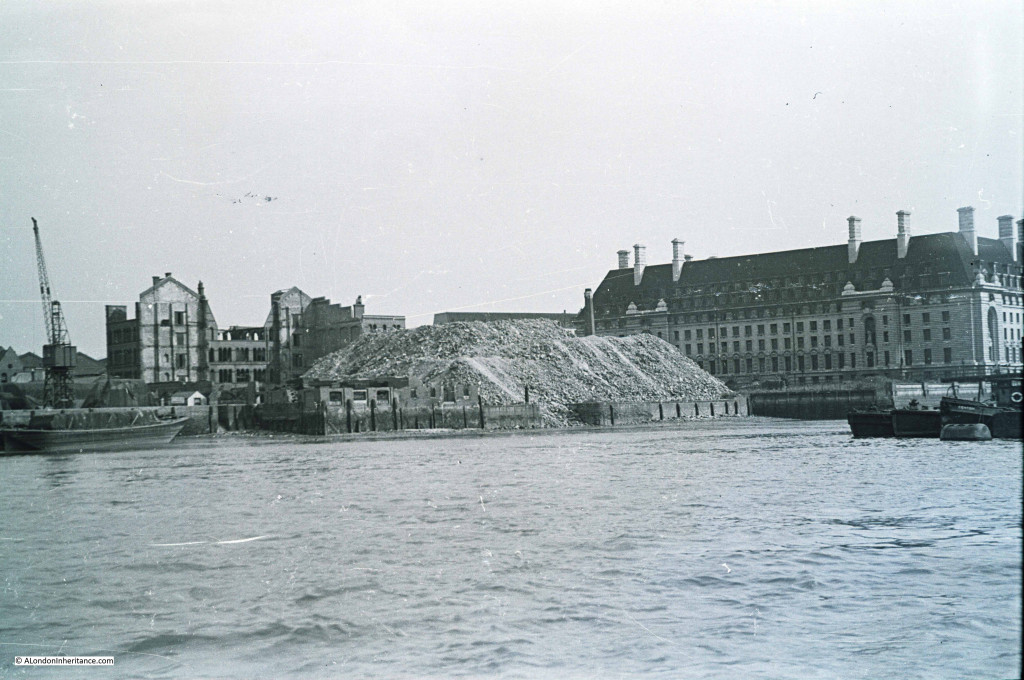
My father took the following photo in early 1947 from the Embankment, just by the base of the Hungerford railway bridge looking over towards the County Hall, the offices of the London County Council. The photo is from the end of a strip of negatives that has suffered some damage. I will process and repair, but for this blog my intention is to present my father’s photos as I first see them after scanning. The photo is interesting for two features, the temporary bridge over the Thames that can be seen running across the river in front of County Hall,  and the large heap of rubble to the left of County Hall. The very start of demolition of the site that would a few years later be the location of the Dome of Discovery for the Festival of Britain. County Hall 1 The location where my father took the photo was easy to find. As well as County Hall being the main feature in the photo, the balustrade in the foreground is still there. Just beyond County Hall to the right are the original buildings of St. Thomas’ Hospital.

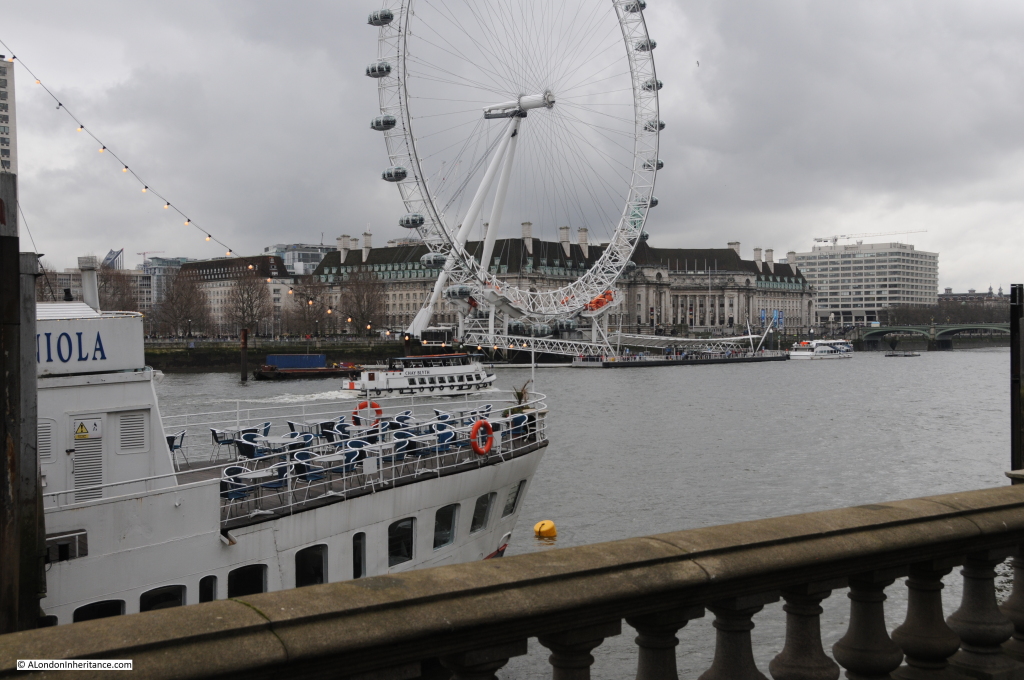
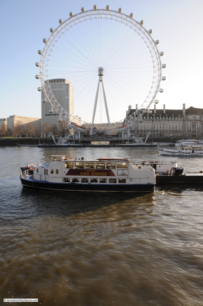
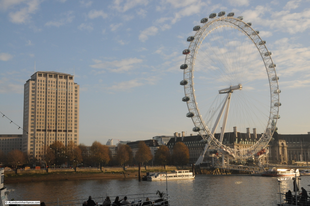
Unfortunately the weather was not as sunny as when my father took the photo 68 years earlier, however my 2015 photo from the same location: County Hall 3 The ship in the foreground was not there in 1947. She is the Hispaniola, launched in 1953 as the Maid of Ashton and entered service in Scotland. She was converted into a restaurant ship and renamed the Hispaniola in 1973, finally reaching her current place on the Thames in 1974.

The temporary bridge over the Thames was one of a number constructed during the war. The aim was to provide an alternative route over the river if the main bridges were bombed. This bridge would have provided an alternative route if the nearby Westminster Bridge was hit. The temporary bridges were removed between 1947 and 1948 so my father’s photo was taken a couple of months before it was dismantled. The route of the temporary bridge was from the north bank to the south, to land adjacent to the County Hall. The following photo is from the landing point on the north bank looking along the line of the bridge to the south bank. These bridges were temporary and there is no evidence of the bridge to be found today, just the London Eye which now dominates this area of the south bank. County Hall 4 There was a second photo on the same strip of negatives, in better condition, and taken looking slightly to the left of the first photo so we get a full view of the location that would host the Festival of Britain and which is now the Jubilee Gardens. As with so much of the land along the banks of the river, the stretch between Hungerford and Westminster bridges was a continuous stretch of warehousing and industrial activity with many wharfs and inlets to the river. County Hall 2 Looking across to the same area now: County Hall 5 To give some idea of the activities which took place along this stretch of the river, the plans for County Hall detail the occupiers of the site prior to the start of the construction. Adjacent to Westminster Bridge was the Westminster Flour Mills, then came the Lambeth Borough Council Works department with Acre Wharf and Vestry Wharf on either side followed by the Cross and Blackwell factory at Soho Wharf, then extending past the County Hall site was the London County Council Works Department. The whole stretch providing a very irregular frontage onto the Thames, as shown in the 1947 photos.

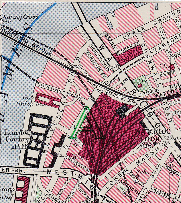
The following map is from Bartholomew’s Reference Atlas of Greater London from 1940. Whilst not showing the wharfs, it does show the area adjacent to County Hall, covered by my father’s original photos, part occupied by the Government India Stores and that a road, Jenkins Street, now long since disappeared extended down to the river’s edge from Belvedere Road.

County Hall Map 1

Construction of County Hall commenced in 1909 with a “coffer dam” being built between January and September 1909 to separate the construction area from the Thames so this could be emptied of water. Work was then started on the embankment wall in September 1909 to build the substantial wall that we see today.

Once the area was separated from the Thames, construction of the foundations and the raft on which the building would sit started. It was during this work that evidence of London’s Roman history was found with the discovery of a Roman boat deep in the sub soil, 19 feet below the river’s high water level. 38 feet in length and 18 feet wide the boat was considered to be a “round-bottomed ocean-going” boat. After seeing the light of day and a very different Thames than the boat must have last sailed down, it was stored by the London County Council before being transferred to the Museum of London.

Work continued on County Hall during the First World War, initial impact of the war was on the slowing of supplies of Cornish granite due to the military demand for rail transport. Reduction of supplies resulted in manpower being moved onto other activities with work slowing considerably after 1915. After the war, work picked up again, with 349 men working on the site in July 1919 rising to over one thousand in 1921. County Hall was finally finished and officially opened in July 1922.

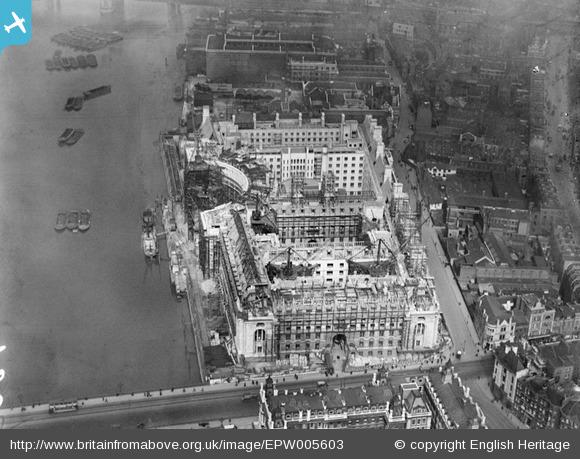
Aerofilms took the following photo when much of the construction up to roof level was nearing completion. The area beyond County Hall is still industrial and warehousing typical of this whole stretch up to Westminster Bridge prior to the construction of County Hall. EPW005603It is fascinating to read how the authority for London was viewed in the first half of the last century. From the 1951 edition of The Face of London by Harold P. Clunn:

“The London County Council is generally admitted to be the largest and most efficiently managed municipal governing authority in the world. It superseded the old Metropolitan Board of Works created in 1855 to watch over the requirements of London, and its 118 councillors were first elected on Thursday, 17 January 1889. On 21 March 1949 it celebrated its Diamond Jubilee. It had often been said that if Parliament ceased to talk for twelve months the country would suffer no inconvenience, and many people would probably be glad. On the other hand, if the London County Council ceased work for a few days indescribable chaos would result, and the health of Londoners would be seriously jeopardized. its housing estates house 500,000 people who pay £5,000,000 a year in rents. In its 1,400 schools 300,000 children are educated by 14,000 teachers.” 

The following postcard with a view taken from the Victoria Tower of the Houses of Parliament shows the area of my father’s photo following clearance and before construction of the Festival of Britain. This must have been around 1949. the temporary bridge has been removed along with all the buildings and rubble from the south bank site, with the land flattened all the way down to the river. It must have been a sight at high tide with the river probably able to extend a fair distance inland at this point. County Hall 6 The view from the Victoria Tower also shows how few tall buildings there were across London. An aspect of the city that would change very dramatically over the following 60 years.

The sources I used to research this post are:

  • The Face of London by Harold P. Clunn published in 1951
  • County Hall, Survey of London Monograph 17, Royal Commission on the Historical Monuments of England
  • Bartholomew’s Reference Atlas of Greater London published in 1940

alondoninheritance.com

The Waterloo Air Terminal

Following the closure of the Festival of Britain, the Southbank site was swiftly cleared apart from the Royal Festival Hall which was always planned as a permanent facility unlike the rest of the Festival buildings.

One part of the Festival site did remain for a few more years and provided support to the rapidly growing Heathrow Airport to the west. In the early days of Heathrow, transport options to the airport were very limited. The Bath Road ran alongside which provided a route for cars / taxis and there were some limited bus services to the airport, however the extension of Underground and Rail services were still many years in the future. The airlines operating out of Heathrow needed to provide passengers for this new and rapidly growing form of transport with easy access to the airport from the centre of London.
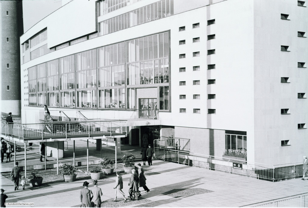
One of the main entrances to the Festival of Britain was on York Road facing the main entrance of Waterloo Station. This entrance also had a dedicated entry / exit to the Underground system at Waterloo with the escalators diving underneath York Road to reach the tunnels to the Northern and Bakerloo lines.

The Festival of Britain was held during the summer of 1951, and two years after closure, on the 27th March 1953 the York Road entrance to the site re-opened as the BEA Waterloo Air Terminal serving passengers on BEA flights and other airlines operating out of Heathrow for which BEA acted as a handler. (BEA or British European Airways was formed in 1946 and merged with BOAC, the British Overseas Airways Corporation in 1974 to become British Airways)

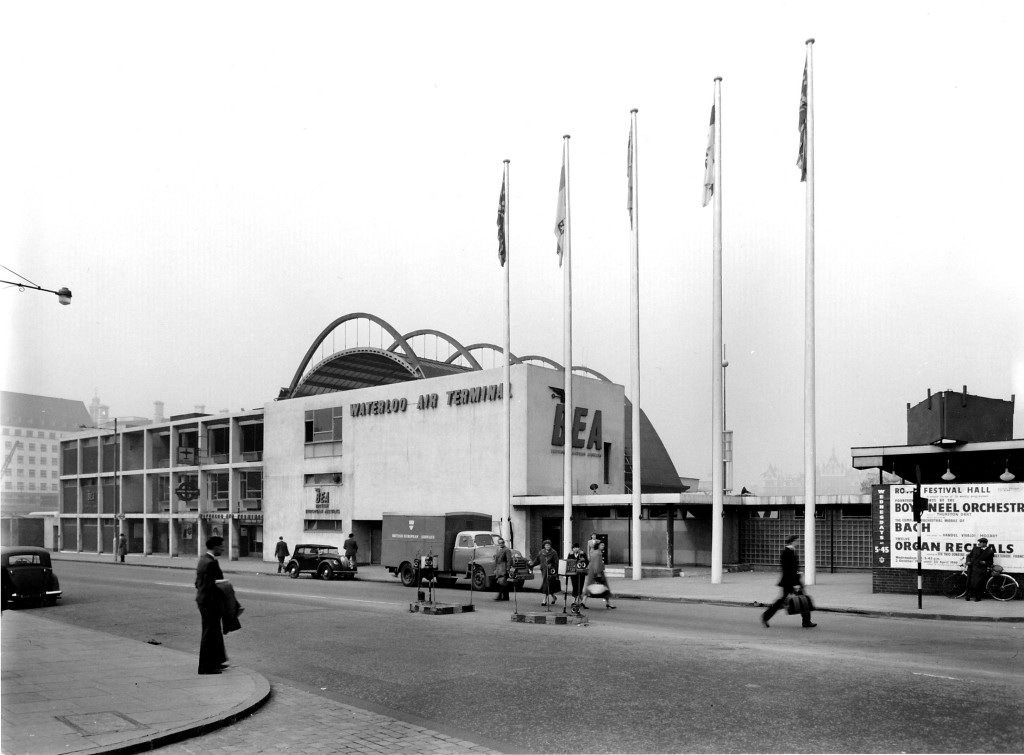
The following photo of the Waterloo Air Terminal was taken in York Road from the end of the access road to the main entrance of Waterloo Station.

Waterloo terminal 1

A British European Airways truck is parked outside the building, a poster advertising events at the Royal festival Hall is on the right. County Hall, the home of what was the London County Council can be seen to the left.

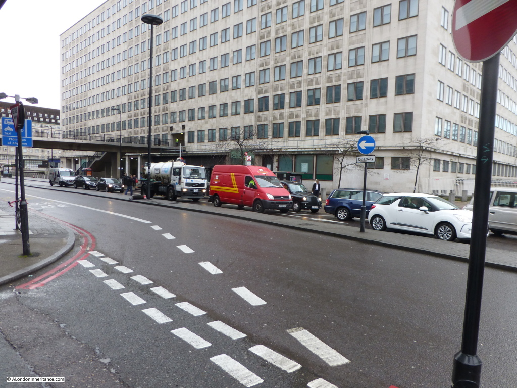
My 2015 photo taken on a damp January morning from roughly the same position is shown in the photo below:

Waterloo terminal 4

In the original photo, the London Underground sign can be seen on one of the columns of the building to the left. In the 2015 photo the underground station is just under the footbridge as it enters the office block. The station entrance and the escalator tunnels down to the main underground stations have not changed in the intervening years which provides a perfect reference point in the old and new photos.

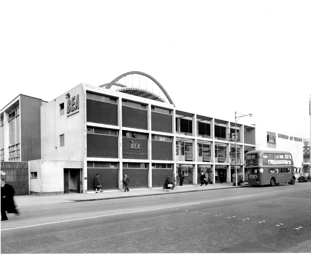
Walk further along York Road towards County Hall and we can look back and get another view of the Air Terminal and the Underground Station entrance can be seen just behind the bus.

Waterloo terminal 3

The Waterloo Air Terminal was in use between 1953 and 1957 and provided check-in facilities, luggage drop-off (which would be collected and taken separately to Heathrow) and a regular coach / bus service provided passenger transport to the airport.

For a short period starting on the 25th July 1955 and ending on the 31st May 1956, a trial helicopter service was run between the Waterloo Air Terminal and Heathrow using the space remaining from the Festival of Britain and a Westland-Sikorsky S55 helicopter, however the high cost of the tickets and the limited capacity of the helicopter did not justify running the service and the coach / bus services remained as the primary means of transport. The helicopter service carried 3,822 revenue paying customers during operation.

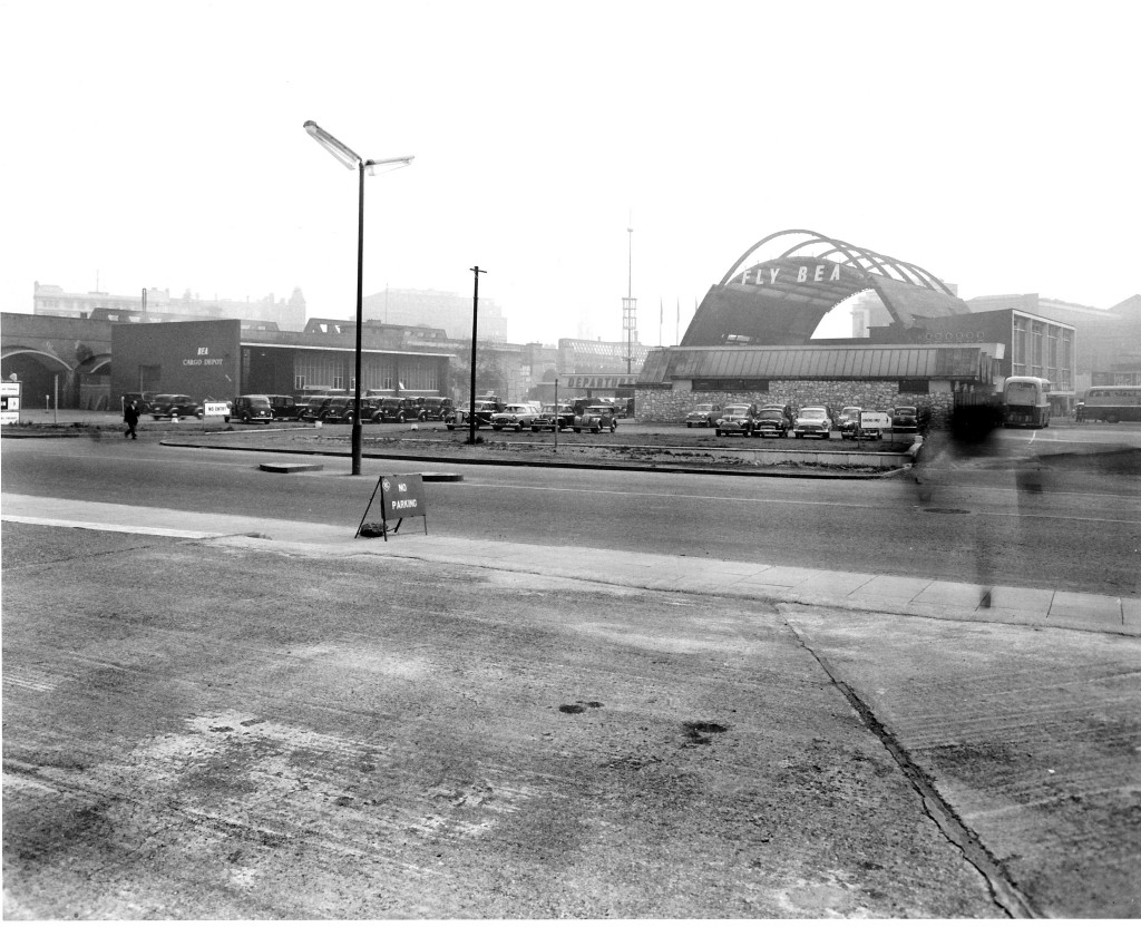
Walk to the traffic lights where Chicheley Street meets York Road, walk down Chicheley Street and cross over to the Jubilee Gardens where we can look back towards York Road. This was the rear of the Waterloo Air Terminal:

Waterloo terminal 2

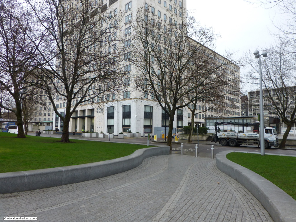
The main terminal is underneath the arches. The building on the left is the BEA Cargo Depot. The coach park is on the right. To the left can be seen the railway viaduct which runs from Hungerford Bridge into Waterloo East. Roughly the same scene in 2015:

Waterloo terminal 5A much larger Air Terminal was constructed by BEA in Cromwell Road in 1957 and the services provided by the Waterloo Air terminal were relocated to Cromwell Road allowing the closure of the site and the redevelopment of the area.

The building that is now located on the site of the Waterloo Air Terminal is Shell Centre, built as the UK Head Offices of the Royal Dutch / Shell group of companies and was constructed on the site shortly after the closure of the air terminal from 1957 to 1962.

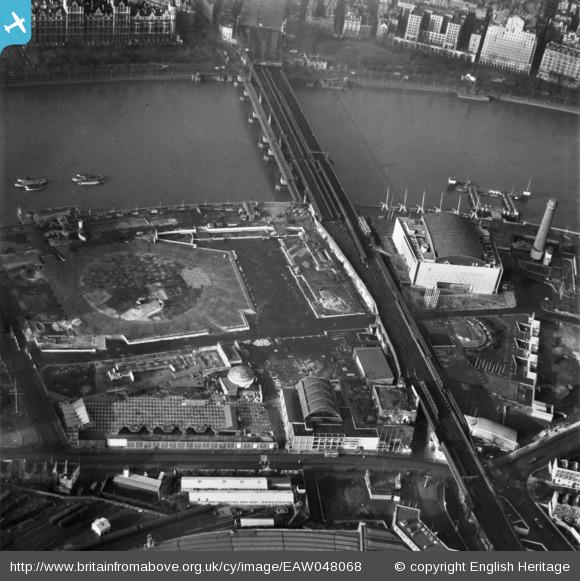
Aerofilms took a superb photo of the site after closure of the Festival of Britain and removal of many of the buildings including the central Dome of Discovery, the outline of which can be seen in the centre left of the photo below. It was the large area occupied by the Dome of Discovery that was used for the helicopter service.
EAW048068

The Waterloo Air Terminal can be seen in the lower centre of the photo with York Road running left to right. The curved roof of Waterloo Station can just be seen at the bottom of the photo. The Royal Festival Hall is clearly seen and to the right is the Shot Tower which would soon be demolished.

The Waterloo Air Terminal was only open for 4 years, but during those years it played a small, but significant role in supporting the development of Heathrow. A clear sign in the immediate post-war years of how Heathrow would become such a key part of London’s transport infrastructure.
alondoninheritance.com