Category Archives: London Monuments

Tindals Burying Ground (Bunhill Fields)

Tindals Burying Ground was the original name of the Bunhill Fields Burial Ground, which today can be found between City Road and Bunhill Row.

The following extract from Rocque’s 1746 map of London shows Tindals Burying Ground:

The original name of the burying ground follows the setting aside of an area of land as a cemetery during the plague year of 1665.

Despite the pressure on space to bury the many thousands of victims of the plague, for whatever reason, the cemetery was not used, and in 1666 a Mr. Tindal took on a lease of the land, enclosed it with a brick wall, and opened the space as a cemetery for the use of Dissenters.

A wider view of the 1746 map, with the burying ground circled:

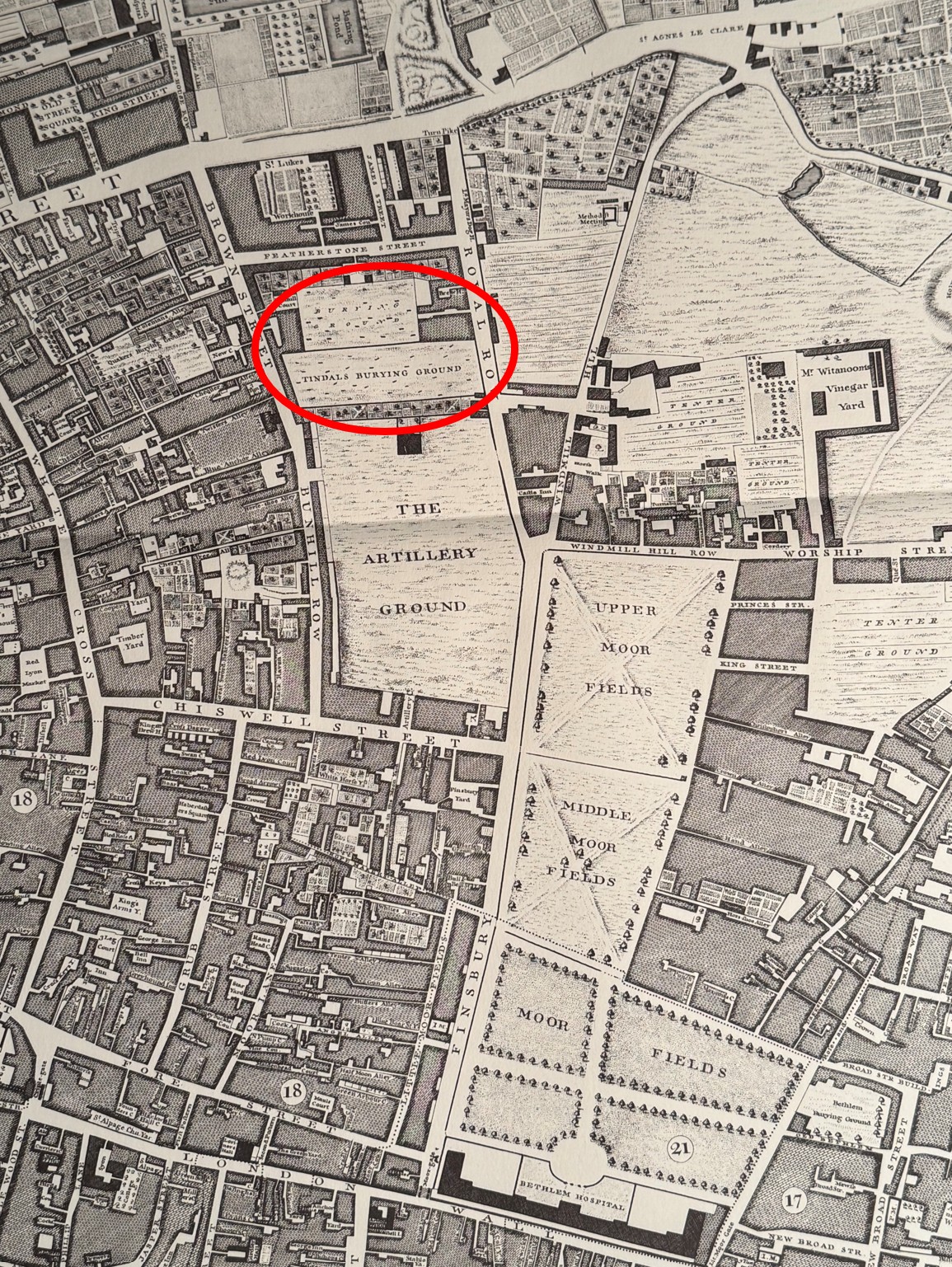
Old Street is running left to right along the top of the map, Royal Row, now City Road, runs to the east of the burying ground and Brown Street runs to the west. The name Brown Street has now been replaced by the extension of Bunhill Row along the western edge of the burying ground.

The use of the name Tindals Burying Ground was not confined to Rocque’s map, but was also in common use across multiple newspaper reports covering events in and around the burying ground, for example, from the Stamford Mercury on the 11th of February, 1768:

“On Saturday night last about ten o’clock, Mr. Hewitt, Watchmaker, in Moorfields, was attacked near Tindal’s Burying ground, by three footpads, who knocked him down, then robbed him of £32 and a dial plate, and beat him so terribly that his life is despaired of.”

Tindal’s Burying Ground was originally described as a place where Dissenters could be buried, and other terms such as Nonconformists were used to describe those within the cemetery. It was also described as the “Campo Santo of Nonconformity” as well as the “cemetery of Puritan England”.

These terms all described someone who did not conform with the governance and teaching of the established church – the Church of England. The 1662 Act of Uniformity defined the way that prayers, teachings, rites and ceromonies should be performed within the Church of England, and the 1662 date of this act explains why there was a need for a noncoformist burial ground four years later in 1666.

I cannot find out whether Mr. Tindal was a nonconformist, but it would perhaps make sense if he was.

The dead who would not have been welcome in a normal Church of England burial ground were buried at Tindal’s, for example in the following account of the burial of an executed criminal in 1760:

“Wednesday Evening, between Five and Six, the Body of Robert Tilling, the Coachman, who was executed on Monday last, for robbing his Master, was conveyed in a Hearse, attended by one Mourning Coach, to Tindal’s Burying Ground in Bunhill Fields, and there interred. The Rev. Mr. Whitefield attended the Corpse, and made a long Oration upon the Occasion, amidst the greatest Concourse of People that ever assembled in that Place; it is thought more than 20,000. The Corpse had been previously exposed in Mr. Whitefield’s Tabernacle near the Burying Ground.”

Robert Tilling was a nonconformist. After being taken from Newgate, he was hung at Tyburn on the 28th of April, 1760, along with four others convicted of burglary. In the report of his execution, he “made a long Speech, or rather Sermon at the Gallows, in the Methodist style”.

The origin of the name Bunhill Fields is interesting, and probably somewhat obscure. Most references talk about the name coming from the earlier name of Bone Hill, and that the site was used for informal burials and also for the 1549 dumping of 1,000 cart loads of bones from the charnel house of St Paul’s Cathedral.

The story of the dumping of bones is that there were so many, and after the following accumulation of the City’s dirt on top of the bones, a significant mound developed, on which some windmills were constructed.

If you go back to the larger extract from Rocque’s 1746 map, and look to the right of the Artillery Ground there is a couple of streets with names of Windmill Hill and Windmill Hill Row, so there must be some truth in the existence of windmills.

As usual, there are several variations of the name as well as stories of the area. There are a number of references that use the name Bonhill. In 1887, members of the East London Antiquarian Society were given a tour of the burying ground, where they were told that “The name was perhaps derived from Bon-Hill, a great tumulus which at one time stood on the Fen outside the City and marked an ancient British burying place, hence the name Bon-hill or Bone-hill fields.”

The City of London Conservation Management Plan states that in 1000 AD there were the “First corpses interred at Bunhill in Saxon times”.

The author Daniel Defoe in his “Journal of the Plague Year” implies that there may have been plague burials in Bunhill Fields, however that does not seem to be the case, and he was probably referring to the purchase of the burying ground which was later taken over by Tindal.

Bunhill Fields occupied a far wider area than just the burying ground, and earlier maps do show some hills spread across the fields.

As usual, there are many variations of names and stories, and it is impossible to be 100% certain of the truth of many of these. The fields were outside the walls of the City, for centuries much of the area was marshland, hence the name Moor Fields.

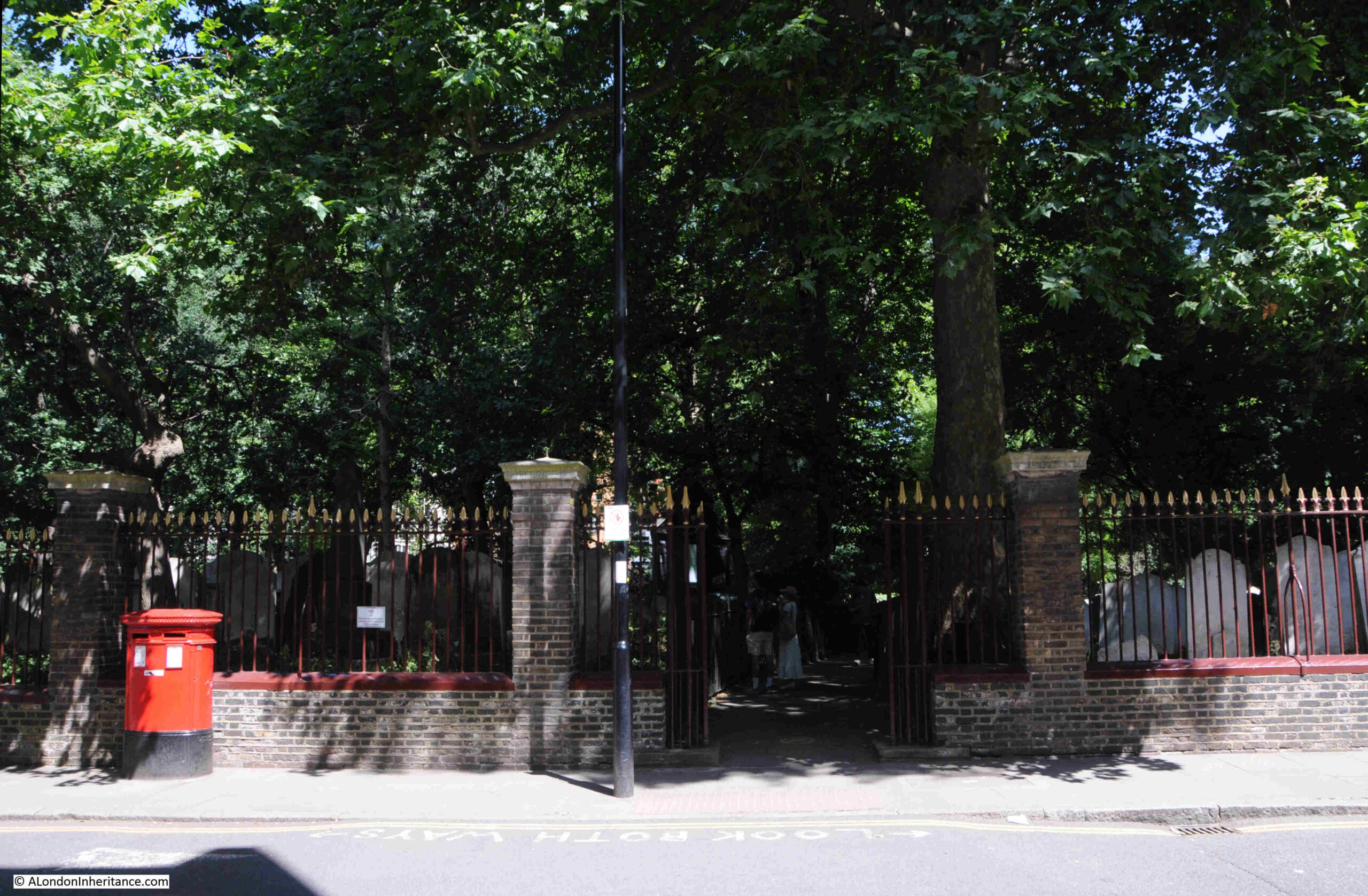
The entrance to Bunhill Burying Ground from City Road:

Gravestone to William Blake and his wife Catherine:

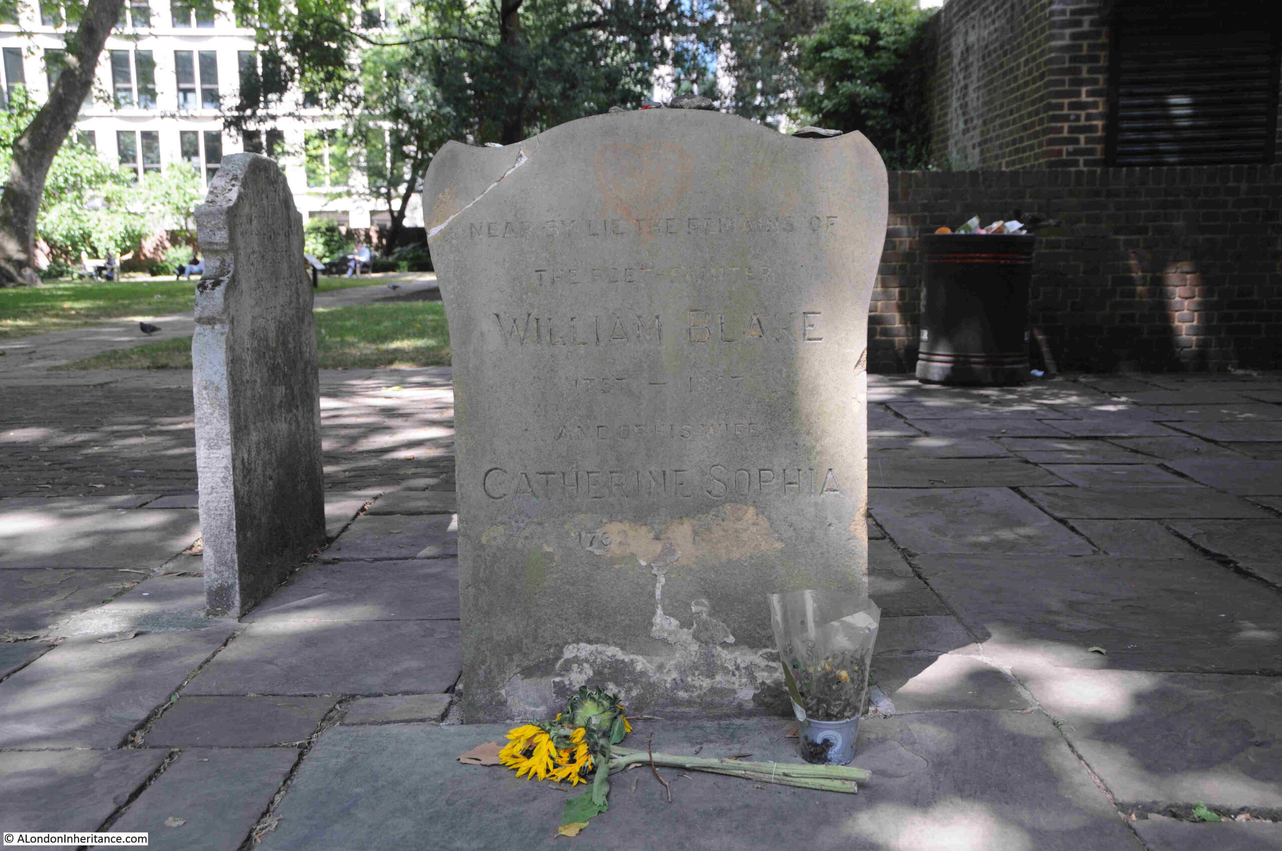
William Blake had some very complex religious views, and views of the roles of good and evil, human nature, sexuality etc. which were very different to those held by the established Church, hence his burial at Bunhill Fields.

The gravestone states “Near bye lie the remains of”, as Blake’s grave was the subject of damage over the years, as well as bomb damage in Bunhill Fields during the last war, so the exact location of his grave was lost.

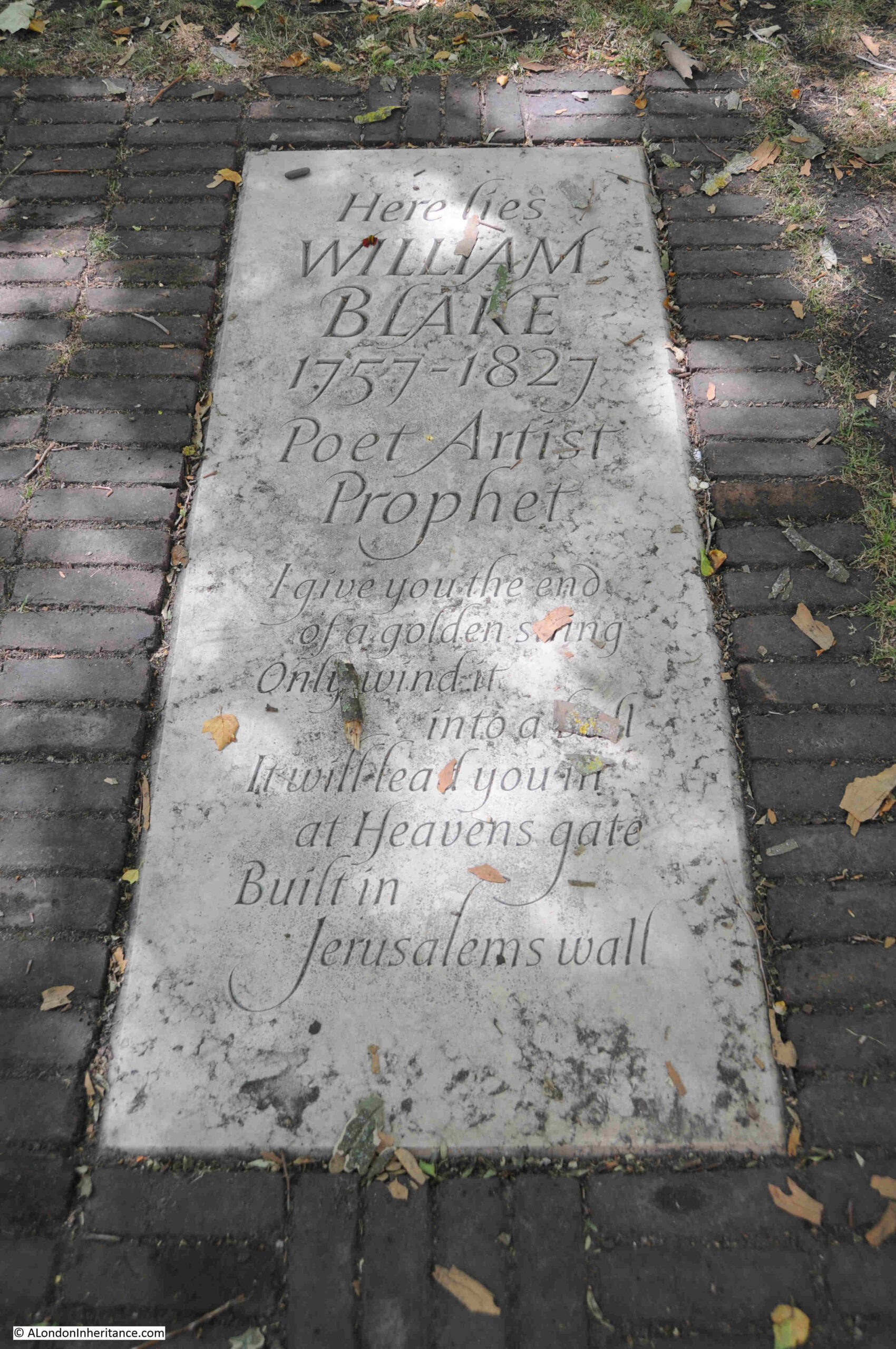
Nearby there is a memorial slab which was installed in 2018 by the Blake Society following work by Portuguese couple Carol and Luís Garrido, who claimed they had identified the location of his grave:

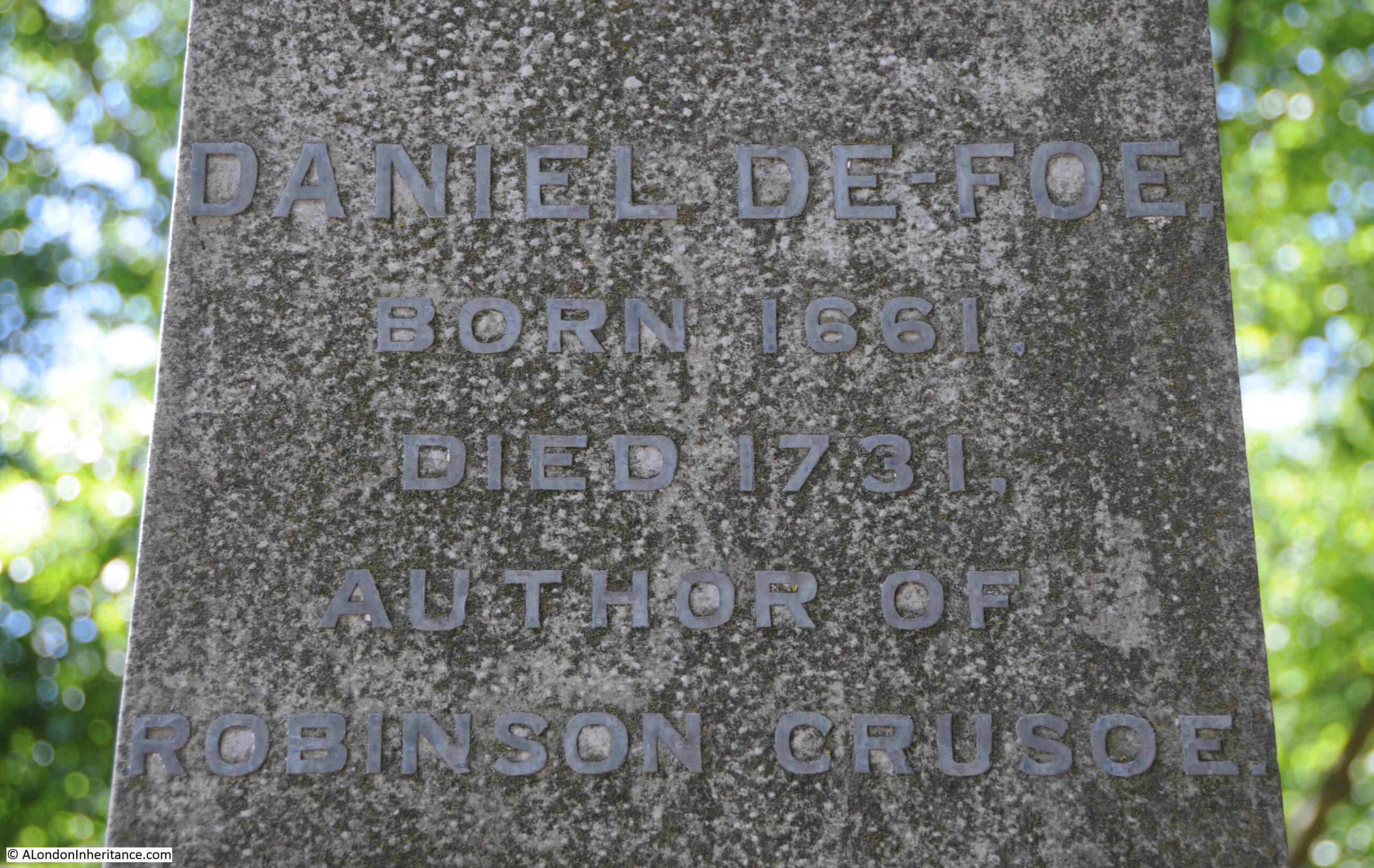
Monument to the author Daniel Defoe (which dates from 1870):

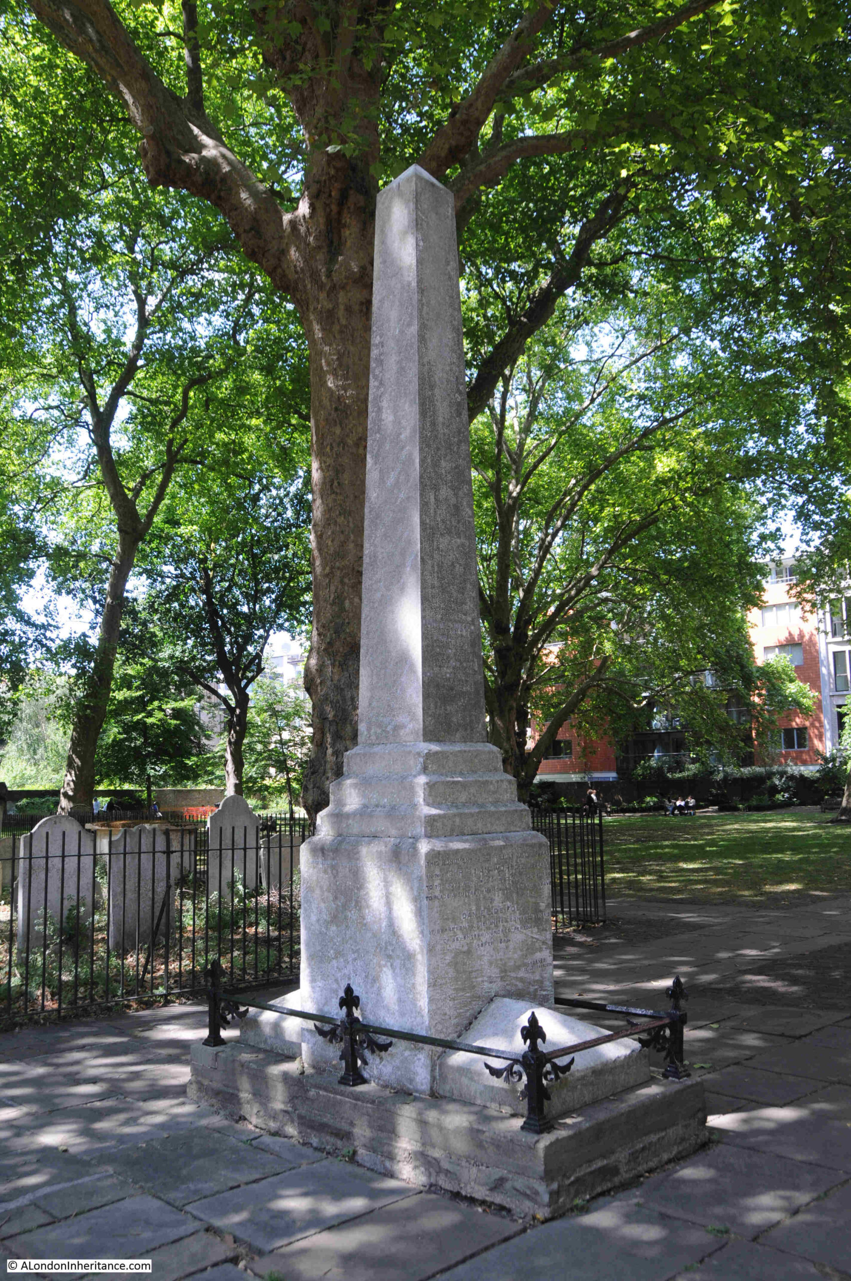
As recorded on the monument, Daniel Defoe was the author of Robinson Crusoe. The date of his birth, 1661, shows that he was very much too young to remember, let alone to write a first hand account of the plague in his Journal of the Plague Year, which in reality he used the accounts and experiences of others to write the journal.

There are a couple of graves at Bunhill Fields which seem to have been the focus of attention over many years. The first is from the 1920s series of books Wonderful London, where the grave of Dame Mary Page is shown:

The focus of interest is not the front of the monument, but the reverse, where it is stated that Mary Page “In 67 months she was tapd 66 times. Had taken away 240 gallons of water without ever repining her case or ever fearing the operation”.

The front of the grave states that she was the “Relict of Sir Gregory Page Bart. She departed this life March 4 1728 in the 56 year of her age”.

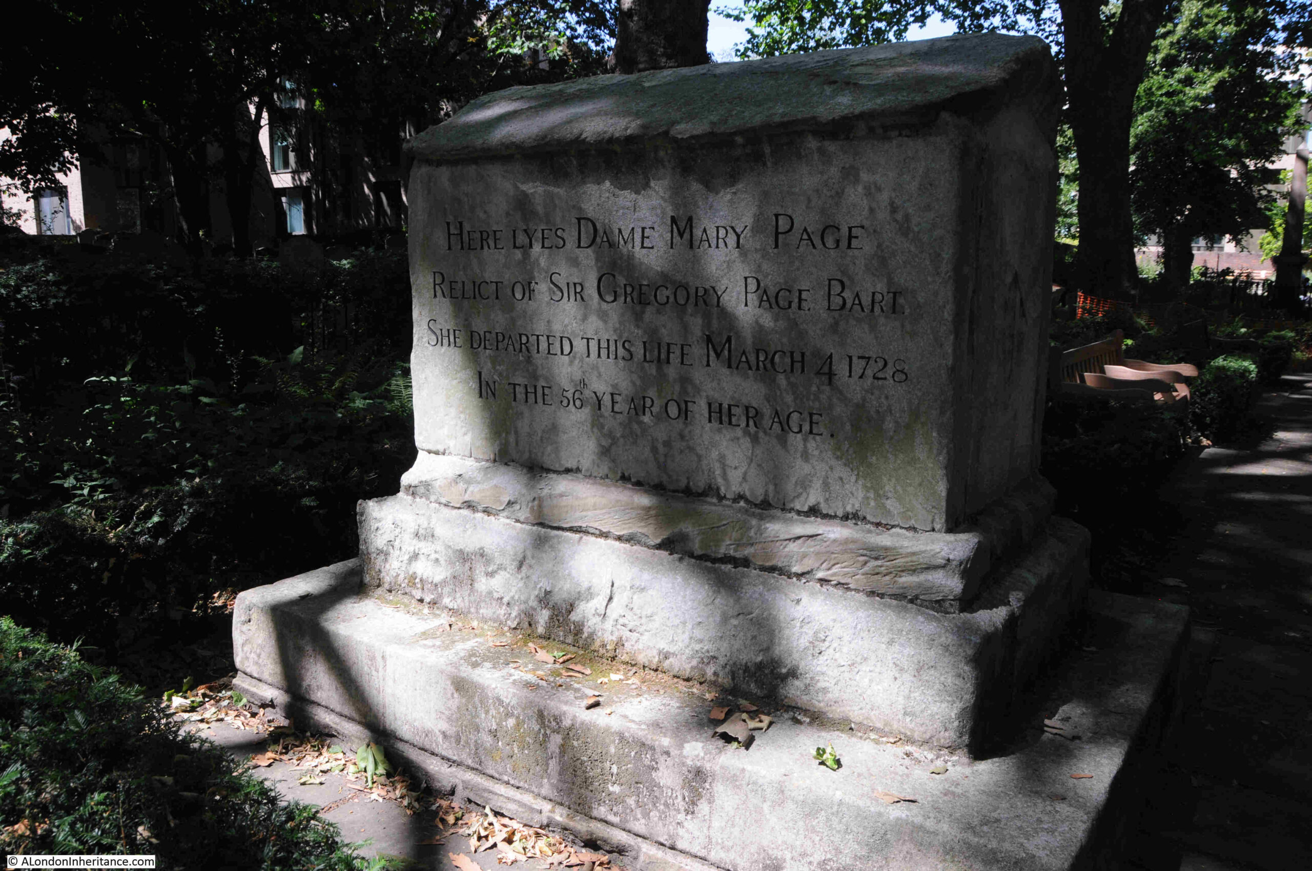
Dame Mary Page was the wife of Sir Gregory Page. He owned a brewery in Wapping and was a Whig politician. He was also involved with the East India Company, including a period when he was a director of the company and this was the source of much of his wealth. He died in 1720 and was buried in Greenwich.

I cannot find any record of Mary’s religion, and it is strange that she was not buried with her husband. To have been buried in Bunhill Fields, she probably held some form of nonconformist views.

The rear of the monument today:

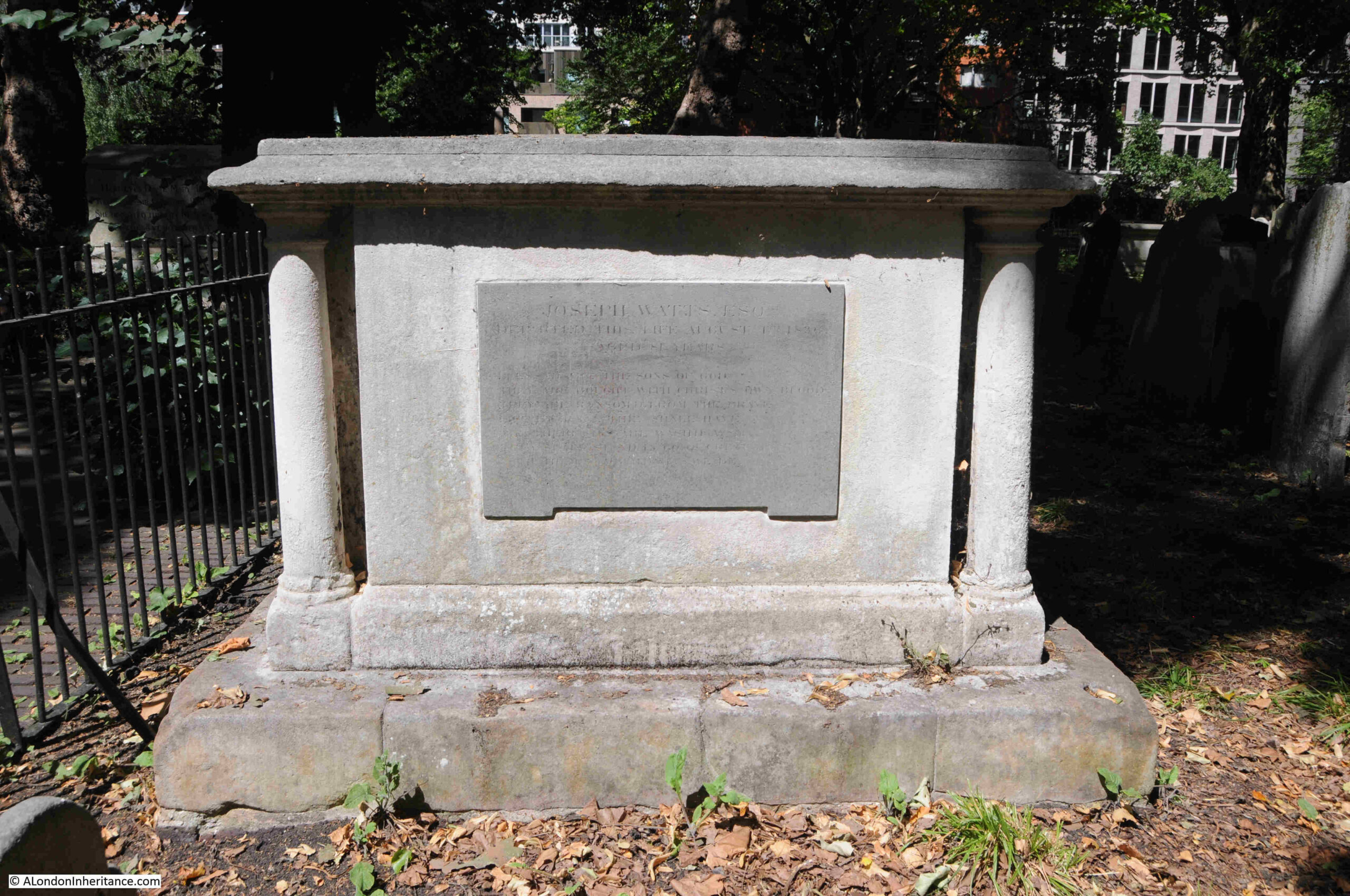
Bunhill Fields as a site is Grade I listed , and many of the individual graves are also listed, including the following grave of Joseph Watts, which is Grade II listed as: ” It is a well-preserved early-C19 chest tomb with still-legible inscriptions and high-quality relief carving”:

The land originally within Tindal’s Burying Ground is believed to have been extended in 1700 and again in 1788, such was the need for a site for nonconformist burials.

Following Tindal’s original lease, it remained a privately owned and managed burying ground until 1778, when it was brought into public management by the City of London.

Along with many other church yards and burying grounds in the mid-19th century, Bunhill Fields was closed for burials in 1854.

The King and Du Pont family monument which is Grade II listed:

The listing states that “It is a prominent and striking monument in an austere Neoclassical style, its polygonal form – derived ultimately from the Hellenistic-era Tower of the Winds in Athens – reflecting the late-C18 fashion for ancient Greek motifs”.

The vault beneath the plinth on which the monument stands holds a number of members of the King and Du Pont families from the late 18th century.

There is an interesting contradiction in attitudes during the 18th century (and indeed in later centuries), between those who were viewed as religious and displaying a range of admired personality traits and those who cost the state money.

Two different examples, both from the same newspaper on the 13th of December, 1754:

“Thursday evening was interred in Bunhill Burying Ground, the body of Mrs. Hannah Peirce, relict of that excellent Divine, Mr. James Peirce of Exeter. The Sweetness of her Temper, the exemplariness of her Behaviour, in every Religion and Condition, breathed a Spirit of a Religion, which is cheerful, patient, meek, and benevolent: Her whole Life was delightfully instructive, and in her 79th Year, she expired with remarkable Calmness and Composure”.

Meanwhile, on the same page as the above, there was an account of another who had just died, but this was very different where the person who had died was summed up by the amount they had cost the inhabitants of the parish:

“On Tuesday died Diana Nicholas, one of the Poor belonging to St. Nicolas Acorns in Lombard Street. In the Year 1691 she was found an Infant in a Basket in that Parish and taken care of: When she grew up she proved an Idiot, and forty years ago was got with Child, and, being unable to make known by whom, brought a further Charge on the Parish: So that it appears by the Accounts she has cost the Inhabitants near £20 per annum for sixty three Years”.

Two very different views of two deaths, where one was described with a range of perfect attitudes and character traits, whilst the other was down to simply how much they had cost the parish over their life.

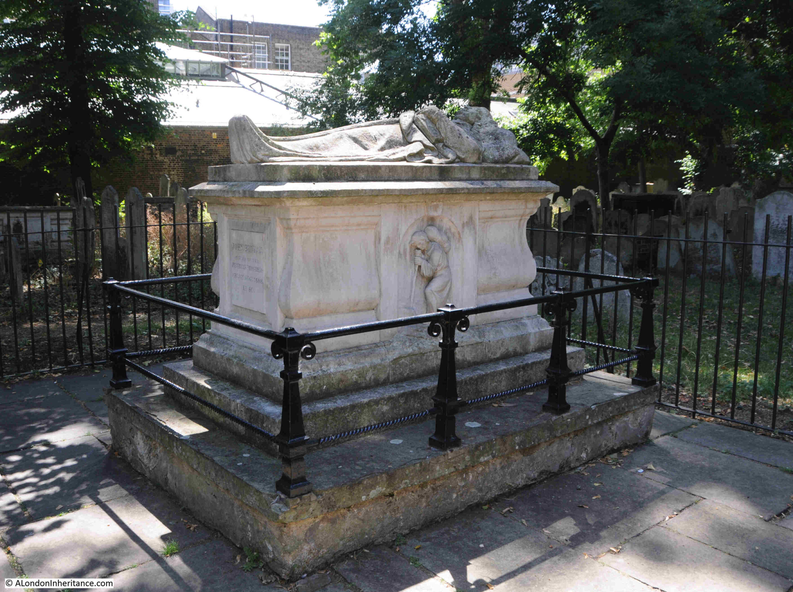
Another of the graves that seems to be regularly featured when looking at Bunhill Fields is that of John Bunyan:

John Bunyan’s monument from the 1890’s book “The Queen’s London”:

John Bunyan was born near Bedford, and served with the Parliamentary forces during the English Civil War. He originally followed the Church of England, attending services in his local parish church.

A chance meeting in Bedford resulted in Bunyan joining the Bedford Meeting, a nonconformist group.

Bunyan took his nonconformist views and preaching seriously, to the extent that he served many years in prison, And it was during one of his spells in prison that he wrote his best known work “A Pilgrims Progress”.

His writing became more widely known after his death, and in the 18th century there were multiple editions of A Pilgrims Progress published, including cheap editions, and editions published in regular instalments.

The book was described as an allegorical writing, describing the journey of Christian from his home, the City of Destruction, to the Celestial City, which has been described as either Heaven or the Holy Land. There were also references to the Celestial City being London, and Christian’s Journey being Bunyan’s journey from Bedford to London.

The grave apparently belonged to one John Strudwick , in whose house in Snow Hill, Bunyan had died in 1688:

The gravestone of Thomas Rosewell. The gravestone is listed, not because of the gravestone (which I think is a later addition or replacement, rather as to who it commemorates, as the listing states *It commemorates a prominent late-C17 Dissenting minister, remembered for his infamous treason trial in 1684*:

The story of Thomas Roswell is one of religious persecution. He was born in Bath and arrived in London in 1645 where he trained as a silk weaver.

London in the middle of the 17th century must have been a hotbed of religious and political divide and conspiracy. Not just with the Civil War, but with the established Church, Catholicism and the many nonconformist groups.

Soon after his arrival in London, Roswell came into contact with the Presbyterians, which led him to train as a nonconformist minister. He became a private tutor and also served as a rector in parishes in Somerset and Wiltshire.

The years following the restoration of the Monarchy and Charles II were a time of persecution of nonconformists, and Roswell was forced out from his parishes in 1662, even though he was a firm Royalist.

Persecution continued and in 1684 he was put on trial for high treason, accused of speaking seditious sentiments during a sermon.

The judge at his trial was Lord Chief Justice, George Jeffreys, also known as the Hanging Judge due to the high number of defendants who were found guilty, resulting in Jeffreys passing the death sentence.

Roswell was also found guilty, and sentenced to death, however there was a significant public outcry and early the following year he received a Royal Pardon.

A look across Bunhill Fields:

An Act of Parliamnet obtained by the City of London in 1867 preserved Bunhill Fields as an open space, and in 1869, the grounds were open to the public.

The burying grounds were not spared during the Second World War, and they suffered serious bomb damage, and post war there has been a continual series of restorations of both the grounds and the gravestones and memorials, enabling the listed memorials to be removed from the heritage at risk register.

Bunhill Fields was also the location for an anti-aircraft gun which probably did not help with maintaining the condition of the site.

The walls and railings surrounding Bunhill Burying Grounds are Grade II listed and date from multiple periods from the late 18th century through to the late 19th century, along with later repairs and renovations.

Apart from a few monuments and graves, the majority are within an area surrounded by railings. It is possible to gain access to graves within this area by asking an attendant.

I have only touched on a very, very small number of the graves at Bunhill.

According to City of London records, there are 2,300 memorials within the burying grounds, and there are believed to be around 123,000 burials.

Each tells the story of those involved in nonconformist and dissenting religious traditions, and many, including that of Thomas Roswell show the risks that having a different belief to the established Church could entail.

And the burying ground now commonly known as Bunhill Fields, almost certainly owes its existence to Mr. Tindal who took a lease on the land in 1665 / 1666, enclosed the ground and opened the burying ground.

alondoninheritance.com

Late 20th Century Sculpture in the City of London – Part 2

In today’s post, I am continuing to track down the works listed in the 1994 booklet published by the Department of Planning of the Corporation of London with the title of “Late 20th Century Sculpture in the City of London”.

The full list was in the original post, and to identify the location of the works covered in today’s post, I have included the maps with numbers for each work which were included in the booklet:

Art was considered an important addition to the public space, particularly as part of the many developments taking place in the City in the later years of the 20th century, and the booklet includes the following statement of the City of London Corporation’s approach:

“The Corporation considers that art can contribute significantly to the quality of the environment. It will therefore encourage the incorporation of art and artworks into the urban scene, in appropriate locations. To this end it is important that the integration of art and artworks into developments and the local environment is considered at an early stage in their design.”

In the last post, I finished with Icarus near Old Change Court, so for today’s post, I made the short walk towards St. Paul’s Cathedral, to find:

13. Cannon Street, Festival Gardens, Young Lovers, Georg Erlich

To the immediate south east of St. Paul’s Cathedral, you will find Festival Gardens, created during and named after the 1951 Festival of Britain:

The gardens consist of a central green space, surrounded by walkways and seating, along with flower beds, and a water feature, and at the western end of Festival Gardens, Georg Erlich’s Young Lovers can be found:

Although the gardens were created for the 1951 Festival of Britain, the “Young Lovers” was not installed until 1973, eight years after Erlich’s death in 1966.

Georg Erlich was born in Austria where he had studied art, but for much of his life he lived in London, from where he had a very successful career, and was exhibited widely in the UK, as well as Europe and North America.

I cannot find out why it took several years after his death to install the Young Lovers, given that the Festival Gardens had been completed in 1951. I suspect it was after a reconfiguration of the gardens in the early 1970s. The original configuration of the gardens is shown in the following photo, and they were later extended to cover the area in the upper part of the photo:

I also cannot find out whether the Young Lovers was originally displayed at a different location, or whether the City of London Corporation intended to install the work at a different location prior to installation at the Festival Gardens.

The work does add a focal point to the western end of the gardens:

Although he did not take any photos of the gardens in 1951, my father did take a photo of the flags on the gardens at the time of the Festival of Britain – one of those times when it is a shame he was relying on a limited amount of film, rather than the almost unlimited number of photos we can take today with digital cameras:

As I left Festival Gardens, I walked past One New Change where there is a modern piece of sculpture. This is Nail, a 12 metre bronze sculpture by Gavin Turk:

“Nail” was installed in 2011, so much later than the works covered in the City of London booklet, however I have included it in the post simply as an example of the continuing use of sculpture to enhance the public realm, and hopefully so that when walking the streets, we stop for a moment to stop and think.

I was walking down New Change to reach my next destination, which was:

14. 20 Cannon Street, The Leopard, Jonathan Kenworthy

The following photo shows the latest version of 20 Cannon Street:

The Leopard, by Jonathan Kenworthy should be just to the right of the corner entrance to the building.

Using Google Street View, I did find the Leopard in 2008, when the side of the building along Friday Street (the street to the right), had larger gardens than we see today.

As well as 2008, Google Street View shows the area in 2009, the following year, and the Leopard has disappeared, as it had by then been relocated to the construction company Wates’ headquarters at Station Approach, Leatherhead, directly opposite the station entrance.

A quick search on Google Street View shows the Leopard can still be found in Leatherhead.

There are also versions of the Leopard by Jonathan Kenworthy in Chester, as well as outside the Lord Beaverbrook Art Gallery in Fredericton, New Brunswick, Canada.

Although not in its original location in the City of London, at least the Leopard was not lost, and for commuters from Leatherhead to London, the Leopard will be part of their daily entrance and exit from the station.

15. Barbican, Ben Jonson Place, Dolphins

The ordering of the list of sculpture is rather strange for a walking route, so from 20 Cannon Street, I then headed to the Barbican, to find the Dolphins:

Ben Jonson Place is a large raised plaza which runs above Beech Street, on the northern side of the Barbican Estate, and the Dolphins is a small work in the middle of a water feature along the southern side of the plaza, as shown in the above photo, and with a close up below:

The Dolphins are not part of the early build of the Barbican Estate, but were added in 1990, and in the City of London booklet on late 20th Century Sculpture, the Dolphins is one of only two where there is no name listed for the creator of the work.

The Dolphins was created by John Ravera, a Surrey born sculptor who trained at the Camberwell School of Arts and Crafts between 1954 and 1962.

He was based in Bexleyheath, Kent, where he had his own bronze foundry, and from where he created a wide range of works including water features, family groups, architectural reliefs, and was known for creating works that demonstrated the freedom of movement of their subjects, as can be seen by the dolphins leaping up from the central ring of small jets of water.

Ben Jonson Place along with the surrounding buildings are built of materials of a very similar colour, so the Dolphins also provides a splash of colour that attracts the eye whilst walking through the estate.

The next work in the list was a very short distance away, at the end of Ben Jonson Place:

16. Barbican, Series of Silver Metal Pipes, Mayer

Working through the list of 20th century sculpture in the City of London raises some interesting questions about the preservation of knowledge about public sculpture.

The City of London booklet did not list the sculptor for the Dolphins, and for this work, it is listed as a “series of silver metal pipes”, with just the last name of the sculptor.

The description is though accurate as it is just a series of silver metal pipes, with their different lengths forming what looks to be a sort of spiral staircase that wraps around the work.

This gives a clue as to its proper name, which is “Ascent”, by Charlotte Mayer, who was born in Czechoslovakia in 1929, and moved to the UK in 1939 with her mother to escape the Nazi occupation.

She trained in London, and lived in the city until her death in 2022.

Many of her works were based on spiral forms, as demonstrated by Ascent at the Barbican. I have no idea as to whether it was mirroring the towers at the Barbican, the tallest residential blocks in London at the time of their construction, but with Cromwell Tower behind, as shown in the above photo there is a possible link.

As far as I could see, there is no reference to either Charlotte Mayer or the name “Ascent” next to the sculpture, as the proper name of the work, which is a shame, as it would be good to have some background to the work and the sculptor on display to add more meaning to the work, rather than being, as described in the booklet as a “series of silver metal pipes”.

17. Barbican, Carmarque Horses, Enzo Plazzotta

The Carmarque Horses by the Italian born sculptor Enzo Plazzotta should be by the waterside terrace in the Barbican:

However despite walking up and down both sides of the terrace, I could not find the work, and cannot remember if and when I last saw it.

One of the things I have realised with writing the blog is that it is easy to take the street scene for granted, and often the buildings, landmarks, statues, plaques etc. that you walk past, just do not register, particularly these days when so many people are walking whilst looking at their mobile phones.

If it has moved, I cannot find a record of where to, although there do seem to be several versions of Plazzotta’s Carmarque Horses to be found in both public and private collections.

Enzo Plazzotta was an Italian born sculptor, who spent the majority of his working life in London, and whilst I cannot find the Carmarque Horses, there are a number of his works remaining across the city.

Despite the rather obscure location, I did have better luck with finding the following work:

18. 125 London Wall, Unity, Ivan Klapez

Hidden away at the end of one of the walkways alongside London Wall, is Ivan Klapez’s Unity:

Ivan Klapez is a Croatian figurative sculptor, who has been based in London for almost four decades.

Unity dates from 1982, and was part of the overall office development of Alban Gate which sits above the junction of London Wall and Wood Street.

The work is at the edge of an alcove, part of which can be seen to the right of the above photo, and looking directly at the alcove, we can see the location of Unity, which is above Wood Street, seen through the windows of the alcove:

Unity is an example of how the surroundings of a public work of art can change. Whilst this was probably once an area of higher footfall, during my visit I did not see another person, and nearby building work has shuttered off part of the space which does not help.

Probably intended as a focal point, Unity is now just a chance find for anyone straying into this part of the walkway alongside London Wall and Wood Street.

The next work on the list is very much in a busy place:

19. Bow Churchyard, Captain John Smith, Charles Renick

The majority of the sculpture listed in the City of London booklet is abstract or figurative. Unlike the first half of the 20th century, and the 19th century, very few are of real people, however in Bow Churchyard there is an exception. This is Captain John Smith:

Text on the plink explains why Captain John Smith has a statue in the City:

“Captain John Smith, Citizen and Cordwainer, 1580 – 1634. First among the leaders of the settlement at Jamestown, Virginia, from which began the overseas expansion of the English speaking peoples.”

Cordwainers were among the first of the craft organisations having received ordinances from the Mayor of London in 1271, and the name is derived from the early English word “cordwaner” meaning a worker in “cordwane” which was leather from the town of Cordova in Spain and the name dates back to around the 12th / 13th Century.

The statue is Grade II listed, and is in the old churchyard (now a paved public space next to the church of St. Mary-le-Bow), as Captain John Smith was a parishioner at the church, although after his death in London in 1634, he was buried in St Sepulchre-without-Newgate.

The statue is based on an early 20th century statue at Jamestown, and the origins of the version next to St. Mary-le-Bow is also explained on the plinth:

“This statue presented to the City of London by the Jamestown Foundation of the Commonwealth of Virginia was unveiled by Her Majesty Queen Elizabeth, the Queen Mother on Monday 31st October 1960.”

The statue was installed in 1960 to commemorate the 350th anniversary of Captain John Smith’s return to England in the winter of 1609 – 1610.

From St. Mary-le-Bow, I then headed to:

20. Guildhall Plaza, Glass Fountain, Allen David

Allen David was born in Bombay, India in 1926, and moved to Melbourne, Australia in 1948, where he studied drawing and architecture.

By the end of the 1960s he had moved to London, and in 1969 he received the commission for the Glass Fountain from a Mrs Edgar, who was the wife of Gilbert H. Edgar CBE, a City of London Sheriff between 1963 and 1964.

I have not seen the fountain working for some time, but when it does, it is flooded with water from multiple clear pipes across the whole of the sculpture giving the impression of covering it in water.

I think the Glass Fountain was installed during a remodelling of the area, as the next work in the list is also in the Guildhall Plaza and dates from 1972, so close to the 1969 date of Glass Fountain. It is:

21. Guildhall Plaza, Beyond Tomorrow, Karin Jonzen

Beyond tomorrow is a very short walk from Glass Fountain, and is close to the 1958 northern wing of the Guildhall:

Karin Jonzen was born in London to Swedish parents in 1914, and studied at the Slade School of Art, and during the war, she worked as an ambulance driver.

After the war, she made the decision to concentrate on figurative sculpture, and in 1951, one of her works was included in the Festival of Britain exhibition.

I had a look in the guide book for the South Bank festival site, and under “New Sculpture, Painting and Design”, is listed:

“Karin Jonzen – Sculpture. At the end of Waterways, near the Waterloo Bridge Gate”, so it was somewhere to the left of the southern approach to Waterloo Bridge.

The guide book did not include a name for the work, there are some references to it being a “standing figure”, but I can find no photos or references as to what happened after the Festival of Britain. Works for the Festival were often made quickly and cheaply, and out of temporary materials (even papier mache), so it may not have survived.

The commission for Beyond Tomorrow was as a result of three works that Jonzen entered into the 1968 Sculpture in the City exhibition, which led to the Corporation of London commissioning two works, one of which was Beyond Tomorrow, the second I will hopefully find in the final post of this series.

Hard to see in the following photo, which was taken in the dark shadow of the northern wing of the Guildhall, but there is a plaque recording the name Beyond Tomorrow, and the date of 1972. It also records that it was given by Lord Blackford and created by Karin Jonzen:

The reference to Lord Blackford is that the first casting of the work was made whilst Karin Jonzen was travelling. On her return she was not happy with the result, so she paid for a new version, created using bronze resin.

Lord Blackford was apparently so impressed with the work, that he paid for a new bronze casting to be made, which is the version we see today, and is why Lord Blackford is recorded as having “given” the sculpture.

22. Bassinghall Street, Woolgate House, Ritual, Antanas Brazdys

With Ritual by Antanas Brazdys, I was really not sure if I had found the right work, in the right place. I knew I was at Woolgate House, but it is a new development, not the Woolgate house that was here in 1969, when Ritual was installed.

Approaching the latest version of Woolgate House along Bassinghall Street:

It is interesting how buildings in the City of London frequently have the name during several decades of demolition and rebuilding, but that is not the subject of today’s post as I was here to find the statue, which today sits beside the street, a bike park, and the building:

The sculpture I found seemed to be too bright and shiny for a 1969 work, as the majority of the late 20th century sculpture featured in the City of London guide was of either stone or bronze, but here ii was, in all its shiny glory:

I was able to confirm it is the work Ritual, as whilst the City of London booklet on late 20th century architecture only has a few photos of the works listed. It does include Ritual, and here it is, outside one of the earlier versions of Woolgate house:

When originally installed, it appears to have been within the concrete approach to the entrance to Woolgate house. Today, it is within a small water feature and an area of planting which looks to be a good improvement from its original position.

Antanas Brazdys was born in Lithuania in 1939. he studied in Chicago and London, and become a senior sculpture lecturer at Cheltenham College of Art, and had works exhibited in many sculpture exhibitions, including the 1966 Open-air Sculpture Exhibition, at Battersea Park.

Many of his works are of the same materials and style as with Ritual.

It is interesting as I have worked through the the City of London booklet on late 20th century sculpture in the City of London, how many of the sculptors were from foreign born sculptors – Austria, Czechoslovakia, Italy, Croatia, Swedish parents, India and Lithuania, just in the selection in this post.

I do not know if that was a conscious decision of the City of London Corporation, or whether it was people with different origins and backgrounds who were bringing the creativity to the streets of the City during the later half of the 20th century.

I still have the remaining works in the list to track down, so will feature these in a post later in the year.

alondoninheritance.com

Late 20th Century Sculpture in the City of London

In 1994, the Department of Planning of the Corporation of London published a small booklet with the title of “Late 20th Century Sculpture in the City of London”:

Whilst there has long been sculpture across the City, it was mainly statues, building decoration, and a number of drinking and decorative fountains, the late 20th century saw a significant increase in the number and diversity of sculpture, with many new works being abstract, rather than the typical “man on a plinth”.

It was the aim of the booklet to highlight this increase in number and diversity of type, and how public sculpture added to the interest and enjoyment of public spaces.

The late 20th century was also a time when large scale development became the norm with City transformation, and the use of sculpture across a development (such as at, in 1994, the recent Broadgate office complex), was part of a developers approach to selling a new development as an attractive place to work.

The City of London, as with much of the rest of London, has long been a rapidly changing and very transitory place. Buildings disappear to be replaced by new, shops, cafes and restaurants open and close, businesses move in then relocate, the 19th century building that was a bank is now a luxury hotel etc.

A work of sculpture has a visual as well as a financial value. Types of sculpture are fashionable when installed, and seem unfashionable just a few decades later. Some sculpture, such as that of Mary Wollstonecraft in Newington Green attract polar opposite views from the day they are unveiled.

Statues of (almost always) men, who were considered heroes at the time, are, many years later, considered either tainted or as villains.

I wondered whether any of these issues applied to the sculpture featured in the booklet, just 31 years later, so decided to trace all the works recorded in the booklet to see if they are still in place, or whether they have been moved, or lost.

Fortunately, to help with tracking them down, the booklet includes a list:

As well as a map:

Split between the two halves of the City. The maps shows that some areas are a desert for late 20th century sculpture, whilst in other areas, such as the new Broadgate development at the top of the following map, there is a large number of works, illustrating the relationship between new development and the installation of new sculpture:

So I set out to find them all, and today’s post is the first in a series over the coming months to locate all 38 works of late 20th century sculpture in the City of London, starting with:

1. Temple Gardens, Lamb Statue, Margaret Wrighton, 1971

The Lamb Statue is of a boy holding a book, and is to commemorate Charles Lamb.

Charles Lamb was a poet and essayist. Born in the Temple at 2 Crown Office Row in 1775 where his father worked in the legal profession. On the death of his father’s employer, the family consisting of Charles, his sister Mary and their mother and father had to leave the house tied with his father’s job and move into cramped lodgings nearby.

After a short spell at the South Sea Company, he moved to the East India Company in 1792, where he would spend the rest of his working life. He was employed as a clerk, a job he did not enjoy.

His first published work was a small collection of sonnets that he provided for a book of poems published by Coleridge in 1796.

But it was not until the 1820s that he achieved a degree of fame when he published a series of essays in the London Magazine under the name of Elia (a name he adopted, allegedly the last name of an Italian man that had also worked at the South Sea Company)

However in many ways he had quite a tragic life which probably influenced his writing.

After the death of his father’s employer, the family were forced to move to cramped lodgings, and Charles and his sister Mary seem to have been responsible for supporting the family, and it was the resulting pressure which probably led to his sister Mary, in a fit of insanity to kill their mother and badly wound their father.

Charles took Mary to an asylum, and to avoid her imprisonment, he agreed to look after her at home, which he did for the rest of his life.

Mary did suffer mental health problems for the rest of her life, but she also published works with Charles, including a retelling of Shakespeare for children, a book which is still published today.

He did not marry. His first proposal of marriage to one Ann Simmons was rejected which led to a short period of what at the time was called insanity, probably what we would now call depression.

His second attempt at marriage, with a proposal to an actress Fanny Kelly was rejected, probably because she could not contemplate a life which involved looking after Mary.

The boy is holding a book, with the quotation “Lawyers, I suppose, were children once”, taken from Lamb’s essay on the “Old Benchers of the Inner Temple”.

The statue was the work of Margaret Wrightson, who was born in Stockton-on-Tees in 1877. She studied at the Royal College of Art, and the majority of her work was figurative sculpture, with works consisting of portrait busts and heads.

The statue was created and installed at the Temple in 1928, however it was stolen in 1970, perhaps because of the value of the lead of which the work was made. A fibreglass copy was made and placed in the gardens in 1971.

Given that the work dates from 1928, it seems strange that it is included in a listing of late 20th sculpture in the City of London, however the fibreglass replacement does fall within the late 20th century timings, although rather strange given that it is a copy.

It did though provide an excuse to visit Inner Temple Gardens on a lovely spring day.

The statue is within the hedged ring in the photo below, on the right hand side of the circle:

The long path running along the south of the gardens, between the gardens and the Embankment on the right:

At the eastern end of this long path is another work, which is not included in the listing, probably because this is a lead replica of the “Wrestlers”, with the first century original being found in the Uffizi in Florence:

Inner Temple Gardens are well worth a visit, and are usually open Monday to Friday, between 12:30 and 3 p.m.:

My next stop was at:

2. Fetter Lane / New Fetter Lane, John Wilkes, James Butler, 1988

John Wilkes was one of the major figures in 18th century political life, and he was also a Lord Mayor of the City of London.

He was active in so many ways that a book is needed to cover the breadth and depth of his life, and one was indeed published in June of last year: Champion of English Freedom: The Life of John Wilkes, MP and Lord Mayor of London.

A well as a Lord Mayor of the City where his statue now stands, he was also an MP, magistrate, author and soldier. He was a prisoner in the Kings Bench Prison after being found guilty on charges of libel.

Born in Clerkenwell in 1725, he died in 1797 in his house at Grovesnor Square. His reputation in later life had suffered due to his involvement in the Gordon Riots, where Wilkes was in charge of soldiers who were defending the Bank of England from the rioters, and as part of his defence of the Bank, he ordered the defending soldiers to fire into the crowd.

This action was seen as an act in support of the Government rather than the common people.

On the rear of the plinth are the following words: “This Memorial Statue Was Erected By Admirers And Unveiled in October 1988 by Dr James Cope”.

Dr James Cope commissioned the statue, and money for the statue was raised from present day supporters of Wilkes.

It was created by London born sculptor, James Butler, who died in 2022 at the age of 90., and there is a comprehensive website covering his life and work to be found, here.

3. 2 Dorset Rise, George and the serpent, Michael Sandle

The order in which the sculptures are numbered in the list is not always the best order to walk, and I found number 3 – George and the serpent – after leaving site number 1 – Temple Gardens.

Walking along Tudor Street, I caught a glimpse of the next work, a short distance up Dorset Rise:

This is George and the serpent, a rather stylised version of St. George, on a horse, about to strike a dragon which spirals around a vertical plinth of metal rods:

There is no date for this work in the City of London booklet, however it seems to date from 1988, and was commissioned by Mountleigh Group as part of the surrounding office development. It was the winning entry in a competition held by Unilever who at the time occupied the offices.

Unilever have long left these offices, and George and the serpent now sits in the courtyard of a Premier Inn:

George and the serpent is the work of Michael Sandle, who was born in Weymouth, Dorset in 1936.

Another of his London works is the Seafarers’ Memorial outside the offices of the International Maritime Organization on the Albert Embankment. This work has a similar bold style as George and the serpent:

International Seafarers Memorial, Albert Embankment, taken Friday, 6 March, 2020
cc-by-sa/2.0 – © Robin Sones – geograph.org.uk/p/6577613

The plinth sites within a circular well, and I beleive the George and the serpent operated as a water feature as well as a sculpture.

In the following photo you can see the circular well. Just visible is a pipe leading from below the interior of the plinth to one or more of the metal poles, some of which I believe are hollow to take water up into the sculpture. To the right in the photo are the brass tongues of the dragon, out of which poured water:

There cannot be that many Premier Inns with such an impressive work of art in the courtyard:

My next stop was in Fleet Place, where there were two sculptures in the listing and on the map. The first was:

4. Fleet Place, Man with pipe, Bruce McClean, 1993

However Man with pipe by Bruce McClean could not be found. Fleet Place has had some considerable redevelopment over the last few decades, so whether these changes resulted in the lost of the sculpture, I do not know?

I walked around the square and streets leading onto Fleet Place but could find no trace, and subsequently no record of where it could be, whether I missed the sculpture, or what may have happened to it.

Fleet Place on the day of my visit:

But I did have better luck with the second work listed as being in Fleet Place:

5. Fleet Place, Echo, Stephen Cox, 1993

Fleet Place consists of a central square and a pedestrianised route leading up to Holborn Viaduct, alongside the City Thameslink station. Along the route up to Holborn Viaduct, I found “Echo” by Stephen Cox:

Echo consists of two headless torsos facing each other, and the gender of each figure is rather vague.

As well as Great Britain, Stephen Cox works in India, Italy and Egypt, and the stone used for “Echo” was Indian Granite. A plaque set into the surround dates the work to 1993, and that it was commissioned by Broadgate Properties, if I remember correctly, this was soon after the City Thameslink station was completed, and as part of the redevelopment of the buildings surrounding the station.

6. Queen Victoria Street, Baynard House, Seven ages of man, Richard Kindersley, 1980

The “Seven Ages of Man” is a wonderful sculpture, but is now in a very dilapidated area, sitting within an open space, part of the public walkway between Blackfriars Station and Queen Victoria Street, above street level, and surrounded by British Telecom’s Baynard House:

The Seven Ages of Man is by Richard Kindersley, and as well as a sculptor of works such as that at Baynard House, he is also a typeface designer and stone letter carver, and if you have ever walked down the stairs at Canning Town Jubilee Line Station, you will see his lettering telling a local history story swirling along the concrete walls to the side of the stairs.

A plaque on the small brick wall opposite the sculpture tells us that the work was unveiled by Lord Miles of Blackfriars on the 23rd of April 1990. Lord Miles was the actor Bernard Miles, who. along with his wife Josephine Wilson, was the driving force behind the Mermaid Theatre which opened a short distance away alongside Puddle Dock (see this post for the story of the Mermaid).

The theme of the work, the Seven Ages of Man is taken from Shakespeare’s play “As You Like It” where the following extract tells the story of the seven ages:

Baynard House and the surrounding area, including the Mermaid Theatre are expected to be significantly redeveloped at some point in the coming years, so as well as the Seven Ages of Man, I think it would also be possible to put together the Seven Ages of City Sculpture (with apologies to Shakespeare):

  1. The planned new development, the concept for a work of art, the design competition and commission
  2. The design is complete and work starts
  3. The new sculpture is installed in its new location, and heralded as a focal point for this new place in the City
  4. The sculpture is now part of the day to day environment
  5. The sculpture becomes so familiar to those who live and work in the area that it becomes almost invisible as they pass
  6. The sculpture and / or the area in which it is located becomes dated, out of fashion, or lacks maintenance and falls into disrepair
  7. The area around the sculpture is redeveloped, the sculpture disappears

The Seven Ages of Man is certainly at stage 6 in my list above, hopefully after redevelopment, it will still be part of the new area between Queen Victoria Street and the Thames.

7. Paternoster Square, Paternoster, Elizabeth Frink, 1975

I usually try and avoid having people in photos published on the blog, however this photo, taken on a warm spring day, shows how the placement of a work can become part of the life of a place, with people clustering around to meet. Paternoster is somewhere between ages 4 and 5 in my list above:

With the colour of the stone used for the plinth, Paternoster looks as if it is part of the latest development of the area north of St. Paul’s Cathedral, however it dates from the previous 1960s office development on the same site.

Trafalgar House commissioned the work from Elisabeth Frink, and it was installed on the northern side of the original development in 1975, and unveiled by Yehudi Menhuin.

When the 1960s development was demolished, Paternoster was moved in 1997 to a position on London Wall, near the Museum of London, and restored to its current location in 2003, on a new plinth to match the surrounding buildings.

The name Paternoster is curious. The work is in Paternoster Square, and prior to wartime bombing and post war site clearance, Paternoster Row once ran through the square, east to west, and the statue is just a few feet north of the original router of the street.

Paternoster Row in the late 19th century – hard to believe that this street once ran through Paternoster Square:

Harben in a Dictionary of London gives the source of the name Paternoster Row as from “Paternosters were turners of beads and lived here, hence the name of the street”.

So why is the sculpture of a shepherd and sheep rather than the traditional paternosters that Harben describes as turners of beads?

The Paternoster Square website gives a couple of explanations, including that Elizabeth Frink was inspired by a stay in Cervennes, a mountainous region in France, populated with sheep and their shepherds, alternatively inspiration from Picasso’s 1944 bronze, Man with Sheep, or perhaps the nearby cathedral inspired a deliberate confusion between pater of Paternoster (Our Father) and pastor (shepherd).

The Paternoster Square website gives the name of the sculpture as “Sheep and Shepherd”, and does not mention the name Paternoster, with the word Paternoster only used in the context given in the paragraph above.

What ever the true source of Frink’s inspiration for the work, it blends in really well in Paternoster Square, and provides a focal point for those who use the square.

Although the focus of this post is late 20th century sculpture, I did pass some new works on my walk between those listed in the City of London booklet, one of these was in the overall Paternoster Square development, where Paternoster Lane meets Ave Maria Lane:

This is “Paternoster Vents” by Thomas Heatherwick.

It was the result of a requirement to provide cooling for an electricity substation in the ground below. Surrounding the work are air vents embedded in the pavement, these draw in cool air.

The two parts of the overall work then support two tall warm air vents. Each of the parts of the overall work consists of sixty three identical isosceles triangles of glass bead blasted stainless steel.

Paternoster Vents was installed in 2002. It is surprising how many recent statues, sculpture etc. across London are there to provide cooling to infrastructure, car parks, underground stations and tunnels etc. and to do so in a way that enhances the streets above.

8. St. Paul’s Churchyard, Becket, E. Bainbridge Copnall, 1973

Enter St. Paul’s Churchyard from the south east, look to your left, and you will see Becket:

Becket, by E Bainbridge Copnall is Grade II listed, and shows Thomas à Becket, who was murdered at Canterbury Cathedral on the 29th of December 1170.

In Copnall’s work, he has fallen to the ground, as the four knights surrounding him are about to strike their fatal blows:

The work is of fibreglass resin and was originally installed in 1973, in the south west of the churchyard, having been commissioned by the City of London Corporation. The sculpture was damaged during the storm of 1987, restored, but then was vandalised in 2001, when it was moved to its current location, which is within a quieter part of the churchyard.

Edward Bainbridge Copnall  was born in 1903 in South Africa and trained in London. More of his works can be seen in London where he was responsible for the relief sculptures on the Adelphi.

He died in 1973, so Becket was probably one of his last works, and he certainly captured the final moments of Thomas à Becket:

Not far from the Becket sculpture is another not listed in the City of London pamphlet, as it dates from 2012, a bust of John Donne:

John Donne was born in nearby Bread Street in around 1571and died in 1631.

He was a poet (and his works are still in print), an MP, Dean of St. Paul’s Cathedral, and many more roles in a complex life. It is from John Donne that we get the phrase “No Man is an Island”.

As with John Wilkes earlier in the post, John Donne requires a whole book to cover his life, and a couple of years ago Katherine Rundell published Super-Infinite: The Transformations of John Donne, and back in 2007 there was Donne: The Reformed Soul. Both excellent books that tell the story of a fascinating life that spanned the 16th and 17th centuries.

The work is by Nigel Boonham, and a clever part of the overall installation is within the stones surrounding the base of the plinth, which has been divided up into four segments for the four points of the compass, each highlighting a key part of John Donne’s life, for example to the east is his birth place in Bread Street, and to the west is Lincoln’s Inn where he was a Reader:

To the north of the cathedral, still in the churchyard is:

9. St. Paul’s Churchyard, John Wesley, J. Adams Acton, 1991

The statue of John Wesley dates from 1988 (although the City pamphlet gives a date of 1991 which may have been when it was unveiled), however in reality it is much older as it is a bronze cast from an early 19th century marble statue in Methodist Central Hall, Westminster.

John Wesley’s life spanned the whole of the 18th century, as he was born in 1703 and died in 1791. He was the main founder of the Methodist movement.

He also has a plaque in Aldersgate Street, recording a place and an event where he “Felt his heart strangely warmed”.

Apparently the statue is 5 foot 1 inches tall, mirroring Wesley’s real life height.

The statue is in St. Paul’s churchyard as, despite being at odds with the established Church of England, he did preach a few times in the cathedral.

As with a couple of others in this post, statues and sculptures do serve as a gateway into further research, by prompting more reading about the individual, and for Wesley, this book tells a good story.

10. Postman’s Park, Minotaur, Michael Ayrton, 1973

Michael Ayrton’s “Minotaur” was recorded in the City of London booklet as to be found in Postman’s Park, however despite a good walk around the park, I could not find the sculpture:

The reason being is that it is now just north of London Wall in the gardens between the ruins of the Elsyng Spital Church Tower and Salters’ Hall. I will cover the Minotaur when I walk through that area for the rest of the sculptures listed in the booklet.

11. Old Change Court, Fireman’s War Memorial, John W. Mills, 1991

The Fireman’s War Memorial was listed as being in Old Change Court, however today you will find it a very short distance to the west at the northern end of Sermon Lane:

The memorial was the work of the Firefighters Memorial Charitable Trust and was initially set up as a memorial to the firefighters who worked across the streets of London during the Blitz, and then extended nationally to cover the service of all firefighters during the Second World War.

It was unveiled by the Queen Mother on the 4th of May, 1991 at its original location at the northern end of Old Change Court.

The sculpture shows two firefighters working a hose, with their legs spread to the take the force of the water blasting from the hose, whilst a sub-officer is waving his arms, attracting others to assist.

The sub-officer is believed to be modelled on C.T. Demarne who was the Chief Fire Officer of West Ham Fire Station. Demarne had the original idea for a firefighters’ memorial, and this is located in the Hall of Remembrance at the Headquarters of the London Fire Brigade. Out of this memorial came the plan for the larger, public memorial to those who died in the Blitz.

It then become a memorial to all firefighters who died in the line of duty, the height of the plinth was increased, and the memorial was moved to its current location at the top of Sermon Lane and rededicated on the 16th of September 2003 by the Princess Royal.

There are currently a total of 1,192 names inscribed around the plinth of the memorial, which includes the a relief of two women firefighters (with the roles of Despatch Rider and Incident Recorder), and the names of 23 women who died:

The sculptor was John William Mills, who was also responsible for the Monument to the Women of World War II which can be found in Whitehall. The monument was originally commissioned by the Founder Master of the Guild of Firefighters and had the title “Blitz” and used a quote from Winston Churchill to describe firefighters of the war as “Heroes with grimy faces”:

The following photo is looking south along Old Change Court today. The most recent incarnation of the boarded up building was as the Old Change Bar and Restaurant, now closed, possibly as a result of the Covid period and post-covid working from home reducing the number of potential customers:

Old Change Court had a second entry in the City of London booklet, but there was no sign of the work, but I did find it close by.

12. Old Change Court, Icarus, Michael Ayrton, 1973

Walk down Old Change Court, turn left and you will find Distaff Lane Garden:

Distaff Lane Garden is a relatively new garden in the City, having opened in 2018. What I did find interesting is that it is the first time I have seen the use of What Three Words as a means of locating a City garden:

What Three Words in a really useful application for precisely specifying a location to within a few feet. What Three Words has divided the world into 3 metre squares, with each square being given a unique three word combination.

The idea being that it is easier to tell someone three simple words to tell them where you are, rather than trying to describe the location, remember street names, map references, longitude and latitude etc.

There is a mobile phone app and website, and it is also used by emergency and rescue services – it is a really useful service, and free to use.

Distaff Lane Gardens is at “memo.courier.showed”, and at this link is the What Three Words website showing the location based on these three words.

Michael Ayrton’s work Icarus can be seen through the gates into the garden, and this is the view of Icarus with the church of St. Nicholas Cole Abbey in the background:

As well as Icarus, Ayrton’s other work in the City was the Postman’s Park Minotaur, now relocated near London Wall.

He had a long running fascination with the story of Daedalus, Icarus, and the Minotaur, and these characters feature in a number of his works. Icarus was the son of Daedalus, and the myth of Icarus comes from his attempt to fly using wings made by his father out of bird’s feathers, leather straps and beeswax.

Before using the wings, Daedalus warned Icarus not to fly to close to the sea, otherwise the feathers would get wet, and not to fly to close to the sun, as the heat would melt the beeswax.

He ignored the warning flew too close to the sun, the beeswax melted and Icarus fell into the sea and drowned.

As well as a sculptor, Michael Ayrton was also an illustrator, painter and stage designer.

Born in London in 1921, he died relatively young in 1975 at the age of 54 – a year after Icarus was unveiled in Old Change Court.

There is another version of Icarus to be seen at the Royal Airforce Museum London at Colindale.

That is the first 12 out of the 38 listed in the City of London booklet on late 20th sculpture.

Out of these 12, it is only “Fleet Place, Man with pipe, Bruce McClean” that I could not find anything about. Whether it is hidden somewhere around Fleet Place that I missed, relocated, or lost, so a good survival record for the other 11, although the Seven Ages of Man is now in an unvisited, poorly maintained and dilapidated area, which if and when redeveloped, will hopefully be moved to a more prominent and long term location.

I will carry on working through the list in a future post.

alondoninheritance.com

The Bank Junction – The Historic Centre of London?

There are a number of options for the centre of London, almost all dependent on how you define the centre of a city such as London. For today’s post, I am going to go for the Bank Junction as the historic centre of London – that point where several key roads meet in the City, in front of the Bank of England, Royal Exchange and Mansion House, which until recently, has been a place busy with traffic and people, as this image from the late 19th century illustrates, looking across from outside the Mansion House to the Royal Exchange, when it was described as “The open space bounded by the Exchange, the Bank, and the Mansion House is perhaps the busiest in all the City:

And it was much the same in the 1920s, although there are some subtle differences, including the war memorial that now stands in front of the Royal Exchange as the photo below was taken not that long after the First World War:

This is a very old part of the City, once at the heart of the Roman City, with very many Roman remains having been found deep below the current surface level.

The 16th century “Agas” map shows the key streets of Cornhill, what is now Threadneedle Street, and Poultry, and by the 1682 map of William Morgan, we can see the area around the Bank junction (which is slightly left of centre in the following extract), with the second iteration of the Royal Exchange (after the first was lost during the Great Fire of 1666), and where Poultry and Cornhill meet, we can see the Wool Church Market, at the site of the future Mansion House (see this post on St Mary Woolchurch, and the wool market):

By the time of Rocque’s 1746 map, we can see that the Wool Market has now been replaced by the Mansion House, and the first building of the Bank of England is shown in Threadneedle Street, simply labelled as “The Bank”:

By Horwood’s map of 1799, we can see how the rapid expansion of the Bank of England has taken up so much space between Threadneedle Street and Throgmorton Street:

In all the above maps, there are only four streets converging on the Bank junction – Cornhill, Lombard Street, Poultry and Threadneedle Street. The junction would get far more complex with the “improvements” to the City implemented by the Victorians during the 19th century, which would leave us with the junction we see today in the centre of the following map:

Where we can now see that Queen Victoria Street joins the junction via Poultry, King William Street has been built, with Lombard Street now joining the junction via this new street, and finally Princes Street, which was widened and straightened along the western side of the enlarged Bank of England.

And this was why the Bank junction was so busy. Cornhill to Poultry and Cheapside was for long a significant east – west route. The new Princes Street and King William Street added a north – south route to London Bridge, and Queen Victoria Street provided a direct route down to Blackfriars Bridge along with the Embankment route to Westminster.

To these through routes was added all the local traffic to the offices, shops and businesses across the City of London.

The geology of the area is one of the reasons why the City was established where it is. In the following extract from the brilliant topographic-map.com, the height of the land across the City is colour coded so that the blue / greens represent decreasing height and yellow to red indicates increasing height:

We can see the Bank junction just to the lower right of the centre of the map, and Cornhill is a hill that runs up to the highest land just to the right of Leadenhall Market.

The higher land around and to the right of the Bank junction is not as pronounced today as it was many centuries ago. Building and street levelling over the centuries has resulted in higher ground being much less pronounced, and originally, the land at and to the right of the Bank was one of the two main hills of the City, with the other being around St. Paul’s Cathedral, before the drop down to the Fleet River.

One of the City’s lost rivers, the River Walbrook once flowed slightly to the west of the Bank junction, cutting across where Queen Victoria Street, Poultry and Princes Street now run, at a much lower level to the current street surface.

Bank junction today, looking across to the Royal Exchange, with the Bank of England on the left:

There are two main differences between the view across the junction of today, and that of the recent past.

Firstly, and most obviously, are the tower blocks in the background. Secondly it is the lack of road traffic.

Over recent few years, the City of London Corporation have been restricting vehicle access across the City, and the impact of this can be plainly seen at the Bank. The part of Threadneedle Street to the left of the Royal Exchange has been pedestrianised, and the complex restrictions are summarised in the following extract from the City of London’s website:

I have mentioned this before, but whilst these restrictions have resulted in a much more pleasant place to walk, better air quality, and providing an environment where it is much easier to see the buildings surrounding the junction – it does leave this central part of the City lacking a sense or urgency and activity, of a vibrant and thriving place. It is probably though just the change from the City that I knew for many decades.

Apart from the new Victorian streets, the layout of the Bank junction has not changed that much, just the buildings that line the streets.

This was the view from outside Mansion House, looking across to the Royal Exchange in 1804, where the open space we see today in front of the Royal Exchange, was then occupied by Bank Buildings. The Bank of England is on the left and the tower of the version of the Royal Exchange rebuilt after the Great Fire is on the right:

Image: © The Trustees of the British Museum. Shared under a Creative Commons Attribution-NonCommercial-ShareAlike 4.0 International (CC BY-NC-SA 4.0) licence.

So there has been major rebuilding of the buildings that surround the junction, but the layout of the junction has remained much the same for centuries, with the addition of new streets in the 19th century.

The times when the actual junction has needed a rebuild is when the Bank underground station arrived, and when the junction, and the station below, was seriously damaged by a bomb on the night of the 11th January, 1941, when the bomb went through the road surface and exploded in the booking hall of the station, as illustrated in the following photo:

AIR RAID DAMAGE (HU 640) The Bank of England and Royal Exchange after the raid during the night of 11 January 1941. The bomb exploded in the booking-hall of the Bank Underground Station. The crater, 1,800 sq ft in area, was the largest in London. Copyright: © IWM. Original Source: http://www.iwm.org.uk/collections/item/object/205068679

Many of those in the station at the time where sheltering, and the bomb caused the death of 56 people, with many more being injured, and today there is a plaque in the station recording the event:

Time for a walk around, to look at the streets and the buildings that surround the junction, starting with the streets. In the following photo is the Royal Exchange, and Cornhill is the street leading of to the right of the photo:

Cornhill is an old street, and one of the principal streets of the City. The earliest written record of the street dates from around 1125 when it was recorded as Cornhilla.

The “hill” element of the name is due to the street running up the western slope of the hill that peaks north-east of Leadenhall Market and “Corn” comes from the association with a corn market that was “held here time out of mind”, as recorded by Stow.

In the following photo is Princes Street, running along the western edge of the Bank of England:

An earlier Princes Street can be seen in the 18th century maps shown earlier in the post, however the Princes Street we see today has been straightened with the loss of a northern section, by the 19th century extension of the Bank of England.

In the following photo, the red bus is in Poultry, which is the street leading west out of the junction:

Poultry is another old street, with first mentions being in the 12th and 13th centuries. The name comes from the markets that were held here where poulters sold their produce.

In the above photo, the River Walbrook once ran across the street, in front of the new building in the centre of the view, the Grade II* listed No 1 Poultry, designed by James Stirling in the 1980s, although the building was not completed until 1997.

The photo shows how much land levels have changed over the centuries, as today there is no sign of the small valley in which the Walbrook ran, which was well below the current level of the street surface, which can be seen by a visit to the Temple of Mithras, now on display at the London Mithraeum, built as part of the construction of Bloomberg’s new European headquarters, a short distance to the south.

A slightly different view, with Queen Victoria Street running to the left of the new building:

Queen Victoria Street was built to help with the growing levels of traffic in the City, and to provide a direct route from the Bank junction, down to Blackfriars Bridge, and the new Embankment.

Construction was recommended in 1861 and included in the Metropolitan Improvement Act of 1863. The new street opened in 1871.

The new street resulted in the loss of numerous courts and alleys, as well as streets of a larger extent, which were swept away for its formation. Amongst those which had occupied the site of the new street were Five Foot Lane, Dove Court, Old Fish Street Hill, Lambeth Hill (part), Bennet’s Hill (part), St Peter’s Hill (part), Earl Street, Bristol Street, White Bear Alley and White Horse Court.

To the left of the above photos is Mansion House:

A permanent building for the official residence of the Lord Mayor of the City of London was one of the considerations for rebuilding the City after the Great Fire, however these plans were not realised until the 18th century.

The site of the old market was appropriate as it was located at a junction of important streets, which did not have any significant monuments.

The architect was George Dance the Elder, who at the time was the City of London’s Clerk of Works. and who took on the challenge of designing a building fit for the Lord Mayor of a growing City and which was able to accommodate both ceremonial functions as well as providing rooms for a private residence.

Work started in 1739, with completion in 1758, and the first Lord Mayor to take up residence was Sir Crispin Gascoigne.

The main reception room was (and still is) the Great Egyptian Hall. Not strictly speaking an Egyptian Hall, rather one based on an account by the Roman writer Vitruvius of what such a room may have looked like. The room today has a barrel roof which was the later work of George Dance the Younger in 1795. as the elder Dance had built a large upper storey, which must have looked out of place, and is shown in the following print of the Mansion House after completion:

Image: © The Trustees of the British Museum. Shared under a Creative Commons Attribution-NonCommercial-ShareAlike 4.0 International (CC BY-NC-SA 4.0) licence.

The large blocks on the roof were intended to give the impression of a complete upper floor as a backdrop to the Corinthian portico at the front of the building, but they look more of a distraction than an improvement.

There have been minor changes to the building since the end of the 18th century, but essentially, when viewed from the Bank junction, the building looks much the same today as it did when it was the first major City building at this important junction.

Moving around the junction, and this is the view looking down King William Street, built after approval was given in an 1829 Act of Parliament as part of improvements to the approach to London Bridge. The street was later widened between 1881 and 1884.

In the following photo, the church is St Mary Woolnoth, (see this post for the story of the Church with the Underground in the Crypt). King William Street is to the right of the church, with Lombard Street to the left. Before King William Street was built, Lombard Street ran up to the Bank junction. Lombard Street is an old City street, with a first mention back in 1319, and dependent on spelling, there may have been an earlier record of the street in 1108.

This is the view along Cornhill:

There is a statue in the middle of the road in the above photo, and it is rather appropriate given that much of the Bank junction sits on top of Bank underground station.

The statue is to the inventor of the Greathead tunnelling shield – James Henry Greathead:

Greathead was a South African, who came to London at the age of 15 and in 1864 he was apprenticed to the civil engineer Peter Barlow.

Five years later at the age of 24, in 1869, Greathead took on the construction of the Tower subway, the pedestrian tunnel under the river from outside the Tower of London.

Tunneling under the river was a challenge, given the soft, waterlogged nature of the ground, not that far below the bed of the Thames.

To address this challenge, Greathead devised what became known as the Greathead Shield, although it was based on a shield design originally used by Brunel, but with a number of improvements.

Greathead went on to work on other tunnelling projects, a number of which route through the Bank, including the City & South London line, which at the time terminated at King William Street (now part of the Northern Line), and the Waterloo and City Line, which now has its City termination at the Bank underground station.

The statue of Greathead is relatively recent, dating from 1994, when it was placed there for a specific reason. If you look below the statue of Greathead, at the area between the feet of the statue and the stone plinth, there is a grill that runs the full circumference of the statue, revealing its true purpose, as it is an air vent for the station beneath, and rather than just have a plain air vent, the statue of a person who was one of those responsible for the continuous improvement in tunnelling under London was a suitable addition to sit on top of Bank underground station.

We now come to the Royal Exchange:

The history of the Royal Exchange goes back to the City of London’s position as a major trading centre.

Long before the days of electronic communications, trading was a person to person business, with traders meeting and agreeing on prices, terms etc. All these embryonic activities led to institutions such as Lloyds of London, the London Stock Exchange, and all the other various exchanges for metals, coal etc.

In the 16th century, much trading was carried out on the street, or in the small houses and shops that lined streets such as Cornhill and Lombard Street, and there had been calls for a dedicated place where people could meet to trade, agree prices, and generally conduct business of all types.

Enter Sir Richard Gresham who became aware of the opening of a Bourse, or trading centre in Antwerp, one of the major trading centres of Europe. Gresham pushed for such a building to be constructed in the City of London, however despite the project receiving royal support, there was no suitable space available.

The proposal was taken up by his son, Sir Thomas Gresham, who also knew of the Antwerp Bourse, as he was based in the city for a number of years as a trader, working on behalf of the Crown, and trading on his own behalf.

Gresham put his own money into the project, along with significant funding generated through public subscriptions, which supported the purchase of a block of land in Cornhill Street, a short distance from what is now the Bank junction, and occupying the same site as the current Royal Exchange.

The building was opened by Queen Elizabeth I in January 1570, and it was the first, large, Renaissance style building in the City.

This first Royal Exchange was destroyed during the 1666 Great Fire, and was soon rebuilt following a design by Edward Jarman, but, as shown in the maps at the top of the post, it still faced onto Cornhill, and in the area in front of today’s Royal Exchange, there was a triangular cluster of buildings.

The following print shows the Royal Exchange as rebuilt following the Great Fire, with the main entrance facing onto Cornhill:

Image: © The Trustees of the British Museum. Shared under a Creative Commons Attribution-NonCommercial-ShareAlike 4.0 International (CC BY-NC-SA 4.0) licence.

The Royal Exchange consisted of a large central courtyard, surrounded by four wings which held offices for meetings, shops, cellars below for the storage of goods etc, as shown in the following print:

Image: © The Trustees of the British Museum. Shared under a Creative Commons Attribution-NonCommercial-ShareAlike 4.0 International (CC BY-NC-SA 4.0) licence.

This second iteration of the Royal Exchange lasted until 1838, when, as with the first, it was also burnt down, with the following print showing the still smouldering remains of the building:

Image: © The Trustees of the British Museum. Shared under a Creative Commons Attribution-NonCommercial-ShareAlike 4.0 International (CC BY-NC-SA 4.0) licence.

The Royal Exchange was soon rebuilt, following a competition to find a design. The competition was won by the architect William Tite, who seems to have also been one of the judges of the competition.

Tite’s design follows the layout of the original two Exchanges, with a central courtyard surrounded by four wings of offices and shops, however Tite’s design changed the main entrance from facing onto Cornhill, now to face onto the Bank junction.

The buildings that had once occupied the triangular space in front of the building were demolished, and it was opened up so that the full Corinthian portico of the new building faced directly onto the Bank junction, and seems almost to mirror the Mansion House across the junction.

The new Royal Exchange was opened in 1844 by Queen Victoria, with the following print showing the opening ceremony, and also how the new building had opened up the space around this important meeting place of City streets:

Image: © The Trustees of the British Museum. Shared under a Creative Commons Attribution-NonCommercial-ShareAlike 4.0 International (CC BY-NC-SA 4.0) licence.

Within the pediment above the columns in the front of the building, there is a sculpture with the words “The Earth is the Lord’s, and the Fulness Thereof”, which was carved by Richard Westmacott the younger (his father of the same name was also a sculptor), and shows traders, historic, from across the world and from London. There are also small details such as a ships anchor to the left and pots to the right:

The Latin inscription, picked out in gold just below the pediment can be translated as “founded in the thirteenth year of Queen Elizabeth, and restored in the eighth of Queen Victoria”, to recall the founding of the first exchange, and the build of the third exchange to occupy the site.

There are numerous small details around the building, for example, the following has the date of the opening of the building as 1844 in Roman numerals:

And the cipher of Queen Victoria, the monarch who opened the latest version of the Royal Exchange:

It is interesting that the Royal Exchange is the only building that I am aware of in London where both the first version, and the latest, were both opened by Queens. Elizabeth I in 1570 and 274 years later, Victoria.

The steps in front of the Royal Exchange are also where the City of London proclaims a new monarch.

The current Royal Exchange has a glittering gold grasshopper from the arms of the Gresham family:

The Royal Exchange was not the only institution founded by Sir Thomas Gresham. His time travelling and working in Europe had also fostered an interest in learning, in trade, and in the benefits that the arts, technical and scientific achievements could bring to trade.

After his death, the executors of his Will founded Gresham College, to provide education across the arts and sciences, and which opened in 1597. A key aspect of the new college was that teaching was in English rather than Latin, which opened the college up to a much wider cohort of potential students.

The college originally operated from Sir Thomas Gresham’s old mansion in Bishopsgate, and then, rather appropriately for a period at the end of the 18th through the early 19th century, the college was based in the Royal Exchange.

A number of moves later, and today the college is based at Barnard’s Inn Hall, and offers a range of free lectures, both on site and online. There is a lecture on “Sir Thomas Gresham and the New Learning”, on the college’s website, along with many others, which can be found by clicking here.

There is also a whole series of lectures on London, which can be found by clicking here – perfect for winter evenings.

There are very many fascinating lectures and Gresham’s college continues to provide a wonderful resource for learning.

Thomas Gresham was perhaps the first person who truly understood international money markets and international trade. He served three monarchs, Edward VI, Mary and Elizabeth, helping to keep them financially solvent, and during Elizabeth’s reign, his methods and contacts helped to stabilise the national currency.

He apparently could be rather unscrupulous in his dealings, including with his own family, and despite using his own money for the Royal Exchange, and leaving money for Gresham College, he appears to not have been particularly charitable during his life.

His name can also be found in the City with the naming of Gresham Street.

Returning to the Royal Exchange, the use of a building as a place for general trading faded later in the 19th century as specialist trading exchanges were set up to provide a place where trades could be made, meetings held, and news received in a specific and related set of commodities or services.

In 1939, the building became the offices of the Guardian Royal Exchange Assurance Company, and in the late 1980s, the company made substantial changes to the interior of the building, which included replacing the original roof, and an additional upper floor.

In 2001, the building was again refurbished, and reopened as a centre for luxury shops, restaurants and bars, and the Royal Exchange retains this function today.

Entering the Royal Exchange from the open space in front of the Bank junction:

The courtyard interior and roof today:

Next to the Royal Exchange, across Threadneedle Street is the Bank of England:

The Bank of England occupies a significant area of land of some three and a half acres. It has reached this size through a series of rebuilds and extensions over the years since the founding of the institution in 1694 as the Government’s banker, and arrival in Threadneedle Street in 1734, into a Palladian building designed by George Sampson, as the first, purpose built building for the Bank of England.

You can see the first Bank building marked in Rocque’s map of 1746, so much smaller than the complex of today.

The Bank of England has a number of key functions:

  • As the Government’s banker, the Bank of England is the only institution authorised to issue bank notes
  • Although they have shrunk over the past few decades, the Bank of England is responsible for looking after the country’s gold reserves
  • And although the Bank of England is owned by the Government, since 1997 the Bank has been responsible for independently setting monetary policy, for example, by setting interest rates

Rapid expansion of the Bank of England commenced after 1788 when Sir John Soane was appointed as architect to the Bank of England, continuing work on consolidating and expanding the Bank of England and working on the large curtain wall that was finished after Soane stopped working for the Bank in 1833, and which completed the security of the Bank’s complex.

The Bank of England buildings that we see today are the result of a rebuilding programme carried out between 1923 and 1939 by the architect Sir Herbert Baker, and which resulted in the demolition of most of Sir John Soane’s work, and resulted in a rebuild described by Nikolaus Pevsner as “the greatest architectural crime, in the City of London of the twentieth century”.

The Bank of England, facing on to Threadneedle Street, as it was before the rebuild that started in 1923:

A photo showing the extent of the rebuilding between 1923 and 1939, from the 1920s books “Wonderful London” (as is the above photo):

The photo above shows just how the curtain wall surrounding the bank forms an almost castle like structure. Also in the foreground, there appears to be a deep excavation, presumably part of the extensive below ground areas of the Bank.

The castle like curtain wall was supplemented by a Brigade of Guards detachment, who had barracks at the Bank to provide over night security, continuing this service until 1973.

The Bank of England partly faces on to the open space in front of the Royal Exchange, and as mentioned earlier, this was covered in buildings up to the construction of the 1844 building we see today.

There are two large monuments in this open space. The first is a memorial to the “officers, non-commissioned officers and men of London who served King and Empire in the Great War 1914 – 1919”:

The memorial was erected after the First World War, and an additional inscription was added at the bottom of the memorial for the Second World War.

The memorial records the names of all the London Battalions that fought in the Great War, and it is a reminder of how battalions were formed from local areas and of people with specific interests, so you have the 11th Battalion Finsbury Rifles, the 17th Battalion Poplar & Stepney Rifles, the 28th Battalion Artists Rifles etc.:

The second monument is to the Duke of Wellington, which was unveiled on June the 18th, 1844:

The monument is here, in front of the Bank of England and Royal Exchange as a thank you from the City of London for the Duke’s help in getting the London Bridge Approaches Act of 1827 through Parliament. There is a full explanation on a plaque on the monument:

The Duke of Wellington also now sits on an air vent to the station below, as can be seen by the grill in the above photo.

The plaque mentions that a piece of granite from London Bridge was set into the pavement by the statue prior to the removal of the bridge to Arizona:

Each of the buildings and institutions covered in this post deserve a dedicated and much more comprehensive post, such is the history at this key City of London road junction. The other aspect that deserves a much fuller write up is the underground station that sits beneath the road junction.

Bank Station was one of very few London Underground Stations that had no above ground buildings, however Bank can no longer claim this distinctive feature following additional entrances to the station across an ever expanding area, including the entrance to Bank Underground Station that is now on Cannon Street.

But as you walk around the Bank junction, there are a number of access points, where stairs lead you down to the station below:

Whether or not you agree that the Bank junction is the historic centre of London, it is a place where major routes across and out of the city all join, and it is a place where three key and early City of London Institutions have and are based.

The Royal Exchange, although no longer supporting its original purpose, once represented the trading heart of the City, Mansion House continues to be the public face of the City’s independent governance, and the Bank of England represents the City’s role in the financial management of the country.

If you are interested in a bit of a deep dive into two of the places covered, I can recommend:

  • Till Time’s Last Sand – A History of the Bank of England, 1694 – 2013 by David Kynaston
  • Gresham’s Law: The Life and World of Queen Elizabeth I’s Banker by John Guy
  • Sir Thomas Gresham and Gresham College: Studies in the Intellectual History of London in the Sixteenth and Seventeenth Centuries, edited by Francis Ames-Lewis

In addition to the Gresham lectures, you may also be interested in the following film that I found whilst researching today’s post at the Imperial War Museum collection.

Titled Britain at War, it is a film which unusually is mainly in colour, and has a lengthy section on London starting at 8 minutes, 30 seconds (it will probably not appear in the emailed versions of this post. Click here to go to the website where the film will appear in the post.)

alondoninheritance.com

York Buildings Stairs and the Watergate

The following photo is from the 1890s book, “The Queen’s London”, and shows the Water Gate between Buckingham Street and the Embankment Gardens:

The caption underneath the photo reads: “In a corner of the public gardens on the Victoria Embankment, at the foot of Buckingham Street, is the ancient Water Gate to York House, a mansion begun by Inigo Jones for the first Duke of Buckingham. It is a beautiful monument of the famous architect’s skill, and can challenge comparison with similar work by any of the Italian masters. The old Water Gate is the earliest ornamental archway in London. It is interesting, moreover, as showing the former level of the Thames. This part of town was a very different place once, when the nobles fancied it for their mansions, or even prior to the making of the Embankment, when it was regularly lapped by the tide.”

The above description, written around 130 years ago applies equally today, and the Water Gate has been a regular feature in books that covered the key features of the city at the time of publication, and the Water Gate made another appearance in the 1920s volumes of “Wonderful London”:

Apart from the architecture, the really fascinating thing about the Water Gate is that it shows how much of the Thames was taken up by the construction of the Embankment, and with a walk up Buckingham Street, it demonstrates the topography of the area, and how we can still see the relatively steep descent from the Strand down to the foreshore of the river.

Rocque’s 1746 map shows the Water Gate and surrounding streets as they were in the middle of the 18th century. They are shown in the following extract, in the middle of the map, where the Water Gate is part of York Buildings Stairs:

The map shows that the Water Gate faced directly onto the Thames foreshore, and whilst the Water Gate was an unusual feature for Thames Stairs, York Buildings Stairs were just another of the Thames Stairs that lined the river, and looking along the river in 1746, we can see other stairs. Salisbury Stairs, Ivy Bridge, Black Lyon Stairs and Hungerford Stairs, all lost with the construction of the Embankment.

The Embankment was built between the mid 1860s and the early 1870s (there are various dates either side of these dates, dependent on exactly what start and completion meant), and around 15 years before the start of construction, John Wykeham Archer created the following water colour of the Water Gate:

Image: © The Trustees of the British Museum. Shared under a Creative Commons Attribution-NonCommercial-ShareAlike 4.0 International (CC BY-NC-SA 4.0) licence.

The Thames was much wider before the construction of the Embankment, and the foreshore would have been a much shallower slope down to the centre of the river.

The above image shows grass growing across part of the foreshore, and a sunken boat to the right.

The sunken boat must have been just one of thousands of old wooden boats that were abandoned on the river and gradually decayed, sank, and became part of the river’s story. This has been happening from at least the Roman period, and on the southern side of the river, a Roman boat was discovered when excavating the ground ready for the build of County Hall.

I wrote about the County Hall Roman boat in this post, and it again illustrates how much wider the river once was, on both northern and southern sides of the Thames.

Also in the above image, there is a brick wall along the back of the Water Gate. Whilst this may have been to keep back very high tides on the river, its primary purpose seems to have been to create a terrace along the side of the river, as the street was called Terrace Walk.

In the 1746 map, the stairs are called York Buildings Stairs, and this name tells of the building that the Water Gate was once part of, and that once occupied the streets behind the Water Gate in the 1746 map.

The building was York House, shown in the following print, with the Water Gate shown with steps down to the river:

Image: © The Trustees of the British Museum. Shared under a Creative Commons Attribution-NonCommercial-ShareAlike 4.0 International (CC BY-NC-SA 4.0) licence.

The building that would eventually become known as York House was built around 1237 for the Bishops of Norwich, and was then known as Norwich Place. This was the time when Bishops from around the country had a London town house as a London base, to be near the Royal Court, in which to entertain etc. (for another example, see my post on Winchester Palace).

The Bishops of Norwich maintained ownership of the house until Henry VIII gave the house to the Duke of Suffolk in 1536, granting the Bishop a smaller house in Cannon Row, Westminster.

Mary I then took the house and gave it to the Arch Bishop of York, and this is when the house took the name of York House. From then on, the house went through a series of owners who seem to have gained or lost possession of the house at the whim of Royal favour.

The Water Gate dates from George Villiers, the Duke of Buckingham’s ownership of the house, when he carried out extensive repairs and had the Water Gate built in around 1626.

The caption to the photo from the Queen’s London at the top of the post, attributes the repairs and the Water Gate to Inigo Jones, however there is doubt about this and the Historic England listing for the Water Gate (Grade I) states that it was “executed by Nicholas Stone but the design also attributed to Sir Balthazar Gerbier”, and that the alterations to York House carried out at the same time were also by Gerbier, rather than Jones.

The Water Gate and stairs down to the river would have provided a private landing place, enabling the occupants of York House to take a boat along the river, or to return home, without having to use the streets, or a public landing place. The Water Gate would also have stood out along the north bank of the river, and would have been a statement, and an impressive place for visitors to arrive.

York House was demolished in the 1670s, with only the Water Gate surviving. The land behind was developed by Nicholas Barbon into the network of streets we see today.

George Villiers, the 2nd Duke of Buckingham imposed a rather unusual condition on the redevelopment, in that the streets that were to be built spelled out his full title, so if we go back to Rocque’s 1746 map, we can see his full title, including the “of” with Of Alley. I have numbered the street in the order in which they appear in his full title:

Only part of the Duke’s title remains today. Duke Street is now John Adam Street, George Street is now York Buildings, and part of Of Alley has been lost under the development of the land between John Adam Street and the Strand with only half remaining now as York Place. All as shown in the following map (© OpenStreetMap contributors):

The Water Gate today:

The Water Gate lost its connection with the River Thames with the construction of the Embankment between the mid 1860s and the early 1870s. This created the roadway, the Victoria Embankment, walkway along the river, with large retaining walls along the river.

Between the Victoria Embankment and the Water Gate are Embankment Gardens, and part of the gardens and Victoria Embankment are built over what is now the Circle and District Line, along with the sewage system designed by Sir Joseph Bazalgette, which was much needed to avoid sewage being discharged directly into the Thames.

The Water Gate is now a considerable distance from the river, and if the distance measure feature on Google maps is accurate, the Water Gate is now 129 metres from the river – a distance which shows the considerable size of the construction work that formed the gardens and Victoria Embankment.

After the construction of the Victoria Embankment, and the gardens, there was concern about the future of the Water Gate, which by the end of the 1870s was in a very poor state, and in urgent need of restoration.

There were also proposals that the Water Gate should also be moved to sit on the new Embankment wall, facing onto the river. Whilst this would have continued the gate’s original purpose, it would have been completely out of context, and there was no need for such a water gate onto the river as using a waterman to row you along the river was by the late 19th century a redundant mode of travel.

Building News of November 1879 covered the issues with, and proposals for the Water Gate:

“The Metropolitan Board of Works have at last turned their attention to the deplorable condition of York Stairs, or Buckingham Gate, as it is sometimes called, now half buried in the newly made slopes of the Embankment-gardens.

Designed to face with its best aspect the fashionable highway of the day – the river, the building became almost forgotten when that time passed away, until the Embankment again brought the public to its proper front. It is undoubtably a relic worth preserving on account of its artistic merits, independent of the historic interest attached to it.

We wait with interest to learn of the Metropolitan Board of Works with regard to its ‘restoration’. It is hoped that better judgement will be exercised by that practical body than has been in some similar instances.

There can be little question that to allow it to retain its original site must be the best plan. Under some circumstances it might be desirable that such a structure should follow the retreated river margin; but the lines of the modern Embankment, however beautiful in themselves, would be utterly discordant with the old-style water gate. And again, the river is no longer the highway from which the majority of people view our public buildings.

We are glad to see that something is to be done. As we pointed out in a former number, it is quite time the neglected ornament was reinstated to a position of the dignity it deserves.”

One of the proposals for the water gate, to reunite it with the river whilst maintain it in its original position, was to run a pipe from the river, under the Embankment, over the rail tracks of the new cut and cover railway, and to a large pond around the water gate.

This would bring river water to fill the pond, and the construction of the sewer under the new Embankment was expected to ensure that the river water would now be clean. This proposal did not get carried out.

Rather the water gate was restored, and the surroundings of the water gate landscaped, to bring it to a similar state that we see today. The work was carried out by the London County Council (who took over the responsibilities of the Metropolitan Board of Works), and completed in the early 1890s.

A look behind the water gate, and we can start to see the difference in land levels, with steps up to the southern end of Buckingham Street:

In the above photo the railings and steps are all Grade II listed, and are described as “Mid C.18. Cast iron and Portland stone”.

What was Terrace Walk in 1746 is now Watergate Walk, here looking to the west, and steps up to Villiers Street:

And to the east towards York Buildings:

The rear of the Water Gate:

The rear of the Water Gate in 1862, as painted by John Wykeham Archer in 1862, just before the construction of the Victoria Embankment and gardens:

Image: © The Trustees of the British Museum. Shared under a Creative Commons Attribution-NonCommercial-ShareAlike 4.0 International (CC BY-NC-SA 4.0) licence.

Buckingham Street is one of those London streets where the majority of the buildings that line the street have listed status.

In the photo below, the end of terrace building is a 1679-80 town house, built as part of Barbon’s development of the area. It was somewhat rebuilt later in the 17th, and again in the 18th centuries:

A plaque on the building states that Samuel Pepys lived in a house on the site, which must have been the original Barbon development:

Next to the houses in the photo above, is the house shown in the photo below, Grade I listed, with the listing dating it as “c.1676-77 with early C.19 and later alterations”, and as being again part of Barbon’s development of the land formerly occupied by York House:

This house also has a plaque claiming Samuel Pepys as a resident, and it appears he lived in the house between 1679 and 1688, when he stayed with William Hewer and that the house was partly in use as the Admiralty Office:

Looking up the full length of Buckingham Street, we can see the way the land gradually rises in height, up to the rear of the building at the very far end, which has a frontage onto the Strand:

One of the very few buildings on Buckingham Street which is not listed, is this building on the south east corner of the street:

The building that was originally on the site was once the home of William Smith – the father of English Geology:

The rear of the water gate from the southern end of Buckingham Street, which again shows the height difference between the street and the gate:

Another house from Barbon’s development of the area. Grade II* listed as a terraced town house, and dating from between 1675 and 1676:

As we approach the northern end of Buckingham Street, where John Adam Street crosses, we can better see the height difference with the rear of the building at the far end, which has a frontage on the Strand. Steps run up from John Adam Street, and the remaining section of the now renamed Of Alley is at the top of the stairs:

One of the interesting aspects of walking the streets between the Strand and the Embankment is the wide variety of architectural styles we can find. The result of the redevelopment of small plots of land over the centuries.

On the corner of Buckingham Street and John Adams Street is the following Grade II listed corner house and office, built around 1860 by R. P. Pullan:

Walking back to the Embankment Gardens, and this is the view towards the west. The Water Gate can be seen lurking low down on the right:

The above view shows just how much the area in front of the Water Gate has changed.

For roughly the first 240 years of the water gate’s existence, it was looking out directly onto the River Thames, and was used as a placed where people could catch a boat to travel across or along the river.

For the last 155 years, the Water Gate has lost contact with the river, now 129 metres to the south, and it looks out across a very different view.

The York Buildings Stairs / Water Gate are also another example of how we have significantly reduced the width of the River Thames over the centuries, and how the river now runs in a channel, rather than a river with a gradually descending and wider foreshore.

For more on this area, you may also be interested in my post on the Embankment Gardens Art Exhibition and the Adelphi.

alondoninheritance.com

Whittington’s Stone and Whittington Park

There is an area around Archway underground station where the name Whittington, and the symbol of a cat features prominently, and this area is the subject of today’s post, to track down the location of some 1980’s photos, the first of which is of the Whittington Stone and Cat:

The same view, forty years later:

The view is the same, although today the railings are painted black, but this change must have been made some years ago, as the red paint of the railings in my father’s photo is showing through.

The Whittington Stone is located a short distance north of Archway station on Highgate Hill, at the point where the street starts to run up to Highgate.

The monument is Grade II listed, and the Historic England listing provides some background as to the history of the stone:

“Memorial stone. Erected 1821, restored 1935, cat sculpture added 1964. Segmental-headed slab of Portland stone on a plinth, the inscription to the south-west side now almost completely eroded, that to the north-east detailing the career of the medieval merchant and City dignitary Sir Richard Whittington (c.1354–1423), including his three terms as Lord Mayor of London. Atop the slab is a sculpture of a cat by Jonathan Kenworthy, in polished black Kellymount limestone. Iron railings, oval in plan, with spearhead finials and overthrow, surround the stone. The memorial marks the legendary site where ‘Dick Whittington’ Sir Richard’s folkloric alter ego, returning home discouraged after a disastrous attempt to make his fortune in the City, heard the bells of St Mary le Bow ring out, ‘Turn again Whittington, thrice Lord Mayor of London.”

The listing states that the memorial stone was erected in 1821, however it replaced an earlier stone, and I found a number of newspaper records of the existence of a stone from the 18th century, including the following from the 24th of October, 1761:

“Monday Night about nine o’Clock, two Highwaymen well mounted, stopt and robbed a Country Grazier going out of Town, just by the Whittington Stone, of 4s, and his Horse whip. And after wishing him a good Night, rode off towards London.”

A Country Grazier was another name for a farmer who kept and grazed sheep or cows, and the report is a reminder of how in the 18th century, this area was still very rural. Very few houses, and Highgate Hill surrounded by fields.

As the listing records, the stone is the legendary site of where Dick Whittington heard the bells of St. Mary le Bow and decided to return to the City.

What ever the truth of the legend, the inclusion of a cat (which was only added to the stone in 1964) is more pantomime than history, and even in 1824 alternative sources for the cat were being quoted when talking about the stone, as in the following which is from the British Press newspaper on the 6th of September, 1824:

“Towards the bottom of Highgate Hill, on the south side of the road, stands an upright stone, inscribed ‘Whittington’s Stone’. This marks the situation of another stone, on which Richard Whittington is traditionally said to have sat, when, having run away from his master, he rested to ruminate on his hard fate, and was urged to return back by a peal from Bow bells, in the following:- ‘Turn again, Whittington, Thrice Lord Mayor of London’.

Certain it is, that Whittington served the office of Lord Mayor three times, viz, in the years 1398, 1406 and 1419. He also founded several public edifices and charitable institutions. Some idea of his wealth may be formed from the circumstance of his destroying bonds which he held of the King (Henry V) to the amount of £60,000, in a fire of cinnamon, cloves, and other spices, which he had made, at an entertainment given to the monarch at Guildhall.

A similar anecdote to that of the destruction of the bonds, is related of a merchant to whom Charles V of Spain was indebted in a much larger sum; but as Whittington lived long before that time, it is fair to suppose, that, if true at all, the story belongs to the London citizen.

The fable of the cat, by which Whittington is much better known than by his generosity to Hen. V., is however borrowed from the East. Sir William Gore Ouseley, in his travels, speaking of the origin of the name of an island in the Persian Gulf, relates, on the authority of a Persian manuscript, that in the tenth century, one Keis, the son of a poor widow of Siraf, embarked for India, with his sole property, a cat:- There he fortunately arrived, at a time when the Palace was infested by mice and rats, that they invaded the King’s food, and persons were employed to drive them from the royal banquet. Keis produced his cat, the noxious animals soon disappeared, and magnificent rewards were bestowed on the adventurer of Siraf, who returned to that city, and afterwards, with his mother and brothers, settled in the island, which, from him, has been denominated Keis, or, according to the Persians, Keish.”

Keis is the name of the son of the widow in the above story, and still today, Keis is the name of a small Iranian island off the Iranian coast in the Persian Gulf, with much of the island being occupied by what is labelled on Google maps as an “International Airport”.

Whether there is any truth in the story of Keis and his cat, the article serves to illustrate how stories and legends develop and cross boundaries, and how it is almost impossible to be sure of almost any similar stories to Dick Whittington and his cat.

The Whittington Stone with Highgate Hill in the background:

The following map shows the area today, and the red circle marks the location of the Whittington Stone. The red rectangle marks the location of my next stop  (© OpenStreetMap contributors):

But before leaving the stone, there are a number of prints from the 19th century which provide a rather romantic view of Whittington at the stone.

The following print from 1849 is of Whittington hearing the sound of Bow Bells whilst leaning against what was then described as a “milestone” (and in 1849 there is no cat):

© The Trustees of the British Museum Creative Commons Attribution-NonCommercial-ShareAlike 4.0 International (CC BY-NC-SA 4.0)

A milestone would make more sense, as at the time, Highgate Hill was the main route from London to Highgate.

I also looked for views of Highgate Hill and found the following print, dating from 1745 and titled “A Prospect of Highgate from upper Holloway”. The road showing curving up to buildings in the distance is presumably Highgate Hill, and if you look carefully to the right of this road where it starts to curve to the right, there appears to be some form of stone monument:

© The Trustees of the British Museum Creative Commons Attribution-NonCommercial-ShareAlike 4.0 International (CC BY-NC-SA 4.0)

The problems I have with this print is that Highgate Hill did not curve as shown in the print. The following extract from Rocque’s map of 1746, so the same time as the above print, shows the area between Upper Holloway and Highgate (top left). The location of Archway is circled, and the approximate location of where the stone is today is marked:

Another example of how difficult it is to be sure of stories, the appearance of places, and the history of artifacts such as Whittington’s stone.

Whittington’s name, and the symbol of a cat can be found in many places around Archway. Next to the stone is the Whittington Stone pub, a modern version of an earlier pub (I have not included the photo in the post as there were plenty of drinkers sitting outside), and further up Highgate Hill is the Whittington Hospital.

There was another Whittington related place I wanted to find, where my father had photographed some 1980s murals, but before I reached Whittington Park, I found the location of a 1980s photo that I was unsure I would ever find as there were no identifiable features:

Forty years later in 2024:

The shop is on Holloway Road, and is an interesting example of how some types of business occupy the same place for many decades.

Today, the shop is occupied by a hairdresser, as it was 40 years earlier, and judging by the appearance of the place in the 1980s photo, it had already been there for some years.

The persistence of this type of business can be seen in many places across London. Although the names have changed over the decades, they continue to be a hairdresser – a business that cannot be replaced by the Internet, or by changing retail fashions.

The long terrace of buildings on Holloway Road in which the hairdresser is located:

Looking south along Holloway Road, and there is a rather nice painted advertising sign on the side of a building:

A sign advertising “Brymay”, one of the brands of the match manufacturer Bryant & May:

I then reached the Holloway Road entrance to Whittington Park, and it was in this park, 40 years ago, that my father photographed three rather good murals:

The above mural features Dick Whittington sitting on a milestone, along with his cat, both looking back at the City of London (again the stone being a milestone makes sense).

The mural below appears to be a mix of various cartoon and film characters:

And the third mural again features a cat, with a capital W on his tea shirt for Whittington:

The cat shown above was the symbol of the Whittington Park Community Association in the 1970s and 1980s.

Do any of these murals remain?

Next to the entrance to the park there is a pub with a mural on the side:

Not one of those in my father’s photos, but a 2017 variation on the story of Dick Whittington and his cat:

The entrance to Whittington Park from Holloway Road:

To the right of the entrance is a large floral cat sculpture:

And inside the park is another cat. This time in mosaic form, on the ground alongside the main walkway:

I then came to the Whittington Park Early Years Hub, run by the Community Association as a play space for the under fives:

I walked around the building, but any trace of the 1980s murals has disappeared, although there are today painted flowers on some of the walls:

I could not find any other building in the park where the murals could have been located, and the blocks that make up the walls of the building seem to be identical to those in the 1980s photos, so I am sure this is the right place:

Whittington Park is a relatively recent open, green space. In the early 1950s, the site of the park was still a dense network of terrace houses, many of which had suffered some degree of bomb damage.

In the following extract from the 1951 OS map, I have marked today’s boundaries of Whittington Park in red, and the map shows the streets and buildings that were demolished to make way for the park (Map ‘Reproduced with the permission of the National Library of Scotland“):

It is interesting how much of the London we see today is down to wartime planning for how the future London should develop, and one of these plans was the 1943 County of London Plan by Forshaw and Abercrombie. Part of this plan included proposals to increase the amount of open space that would be available to Londoners of the future, and to address the problems with lack of such space in the way that London had developed from the 19th century onwards.

The North London Press on the 11th of April, 1958 records some of the initiatives in the area, and the small beginnings of Whittington Park:

“Under the County of London Plan, over 100 acres of new open space are to be provided within the borough. In February, 1954, the first part – about an acre – of Whittington Park was opened to the public; this will eventually be extended to form a fine new park of over 22 acres.”

The park would expand over the following decades from the one acre of 1954 to the ten acre site of today, short of the 22 acres expected in 1954;.

The names of the streets that were demolished to make way for Whittington Park all have interesting Civil War connections. There is:

  • Hampden Road – named after John Hampden who was a parliamentary leader in opposition to Charles I, and who fought on the Parliamentary side during the war, and died in a fight with Royalist troops at Chalgrove Field, near Thame;
  • Ireton Road – named after Henry Ireton who was a leading supporter of Cromwell, and a key figure in the New Model Army, and who went on to marry Cromwell’s daughter;
  • Rupert Road – although the above two roads were named after Parliamentary figures, Rupert Road was named after Prince Rupert, who became Commander in Chief of the Royalist land forces. After the restoration of Charles II, Prince Rupert again became a key supporter of the Crown and held high positions in the Royal Navy.

Hampden and Rupert Roads are their original names, however Ireton Road was not the original name for the street. It was originally called Cromwell Road, after Oliver Cromwell.

I suspect the name change was to avoid a conflict with another Cromwell Road, as in the early decades of the 20th century there were initiatives to reduce the number of streets with the same name.

In a walk around the park, I only found a single relic of the streets that were demolished to make way for Whittington Park, and it is a war memorial for those who lost their lives in the Great War and who lived in Cromwell Road.

Today, the monument is set into an earth embankment to the left of the entrance of the park:

I cannot find any firm references as to where the war memorial was originally located, but I suspect that it was on the wall of one of the terrace houses that originally lined the street, in a similar way to the existing memorial at Cyprus Street, Bethnal Green (see this post).

These war memorials for single streets really bring home what the impact of the Great War must have been for small communities and individual streets when you see the number of names of those who died in the war, from one single street.

We can get an idea of what the demolished streets may have looked like, by walking along Wedmore Gardens, which is the street bordering the north western edge of the park. The layout of the houses in the street look very similar to those of the demolished streets, and they are of the same age (the streets were built around the 1860s), so looking along Wedmore Gardens, we get an idea of what was once on Whittington Park:

As well as Wedmore Gardens, Wedmore was also the name of the wider estate of which the streets were part, as well as flats to the south eastern side of Whittington Park, which have since been demolished and replaced with new residential building.

Whether there is any truth in the story of Richard Whittington, or Dick Whittington in his pantomime image, returning to the City of London after hearing Bow Bells, he continues to leave an impression on Highgate Hill and the northern part of Holloway Road, 600 years after his death in 1423.

alondoninheritance.com

The Standard, Cornhill

A few week’s ago, my post was about London Maps, and I included one of the strip maps by John Ogilby, who had the impressive title of His Majesties Cosmographer.

John Ogilby was a fascinating character. Born in 1600 in Scotland, he had many professions including a dancer, teacher, translator, publisher and map maker.

With William Morgan, John Ogilby created a very detailed map of London which was published 10 years after the Great Fire of London in 1666 (although it was probably surveyed before the fire). You can find the map on the Layers of London website, here.

Ogilby is probably best known for his atlas of all the major routes in the country, which he published in 1675 under the name of Britannia.

Routes were shown in a strip map format, where several strips were used to follow a route from source to destination. Along the route, towns and villages were listed, as were geographic features, roads leading off the main route, with their destinations listed, landmarks along the route, distances etc.

The map featured in the previous post was from London to Portsmouth, a route which started at the Standard in Cornhill.

The Standard in Cornhill was the starting point for many of the maps with routes that commenced in London, and after writing the previous post, I wanted to discover a bit more about the Standard, but before I head to Cornhill, here is another of Ogilby’s routes. This one a bit longer than the previous map to Portsmouth.

Each of the routes had a header on each page, with the first map having the title of the overall route, total distances, major towns and cities along the route, with individual distances between them.

So if you were planning to journey from the City of London, to Lands End in Cornwall, this was Ogilby’s route, which started with the summary header of the route of 303 miles and 3 furlongs, and started at the Standard in Cornhill:

John Ogilby

The first page of the journey to Cornwall, runs from London to just before Winchester, and just after leaving what was then the limits of London, we cross Knightsbridge, when it was still a bridge:

John Ogilby

We then cross Hampshire, Wiltshire, Dorsetshire and Somersetshire. In the 17th century, counties still had “shire” at the end of the names such as Dorsetshire and Somersetshire, which would later be shortened, but as with current names such as Wilshire, the “shire” recalls the old origins of these counties and county boundaries:

John Ogilby

We then continue travelling through Devonshire, passing through Exeter:

John Ogilby

Then head into Cornwall, before finally reaching Lands End, which faces onto “The Western Sea”:

John Ogilby

So where was The Standard, the start of the Lands End route, and of many other maps, and what was it? Helpfully there is a City of London plaque to mark the site:

Standard Cornhill

The Standard sounds as if it should have been the name of one of the many large coaching inns across London, and which would make sense as a place where journeys across the country commenced, however it was an ancient well / water pump / conduit, and it was located at a key crossroads in the City of London, where Cornhill, Leadenhall Street, Bishopsgate and Gracechurch Street all meet.

The following photo shows the junction of these four roads:

Standard Cornhill

You can just see the blue plaque, on the first floor of the corner of the white building across the junction. To the right of the white building is Cornhill and to the left is Gracechurch Street. The white building also shows how every bit of available land has been built on in the City, as the building is right up against the church of St. Peter, Cornhill, which has an entrance on Cornhill, and the rear of the church can be seen on Gracechurch Street to the left of the white building.

If we look at the four roads leading from this junction, we can see why this was an important location for travelling out of the City.

Gracechurch Street heads south down to London Bridge, which for centuries was the only bridge across the Thames, and therefore the main route to the south.

Leadenhall Street headed to the east, Bishopsgate headed to the north and Cornhill headed to the west, so from this junction, one could travel to the major routes that ran across the country, and was why maps such as Obilby’s used the Standard as their City of London starting point.

London Past and Present (Henry Wheatley, 1891) provides some background detail about the Standard:

“A water-standard with four spouts made (1582) by Peter Morris, a German, and supplied with water conveyed from the Thames by pipes of lead. it stood at the east end of Cornhill, at its junction with Gracechurch Street, Bishopsgate Street and Leadenhall Street, and with the waste water from its four spouts cleansed the channels of the four streets.

The water ceased to run between 1598 and 1603; but the Standard itself remained for a long time after. It was long in use as a point of measurement for distances from the City, and several of our suburban milestones were, but a very few years ago, and some perhaps are still, inscribed with so many miles ‘from the Standard in Cornhill’. There was a Standard in Cornhill as early as Henry V.”

A print, dated 1814 of the “Antient North East View of Cornhill” shows the pump at the crossroads. The print is dated over 100 years after the pump was removed, so whether it was an interpretation of what it may have looked like, or whether it was based on an earlier print is impossible to know:

Standard Cornhill

© The Trustees of the British Museum Creative Commons Attribution-NonCommercial-ShareAlike 4.0 International (CC BY-NC-SA 4.0)

London Past and Present, and many other sources date the Standard to around 1582, however the site seems to have been used as a source of water for many centuries before.

In 1921, as new pipes to carry telephone cables were being laid across the junction, a well which was believed to have been below the Standard was discovered.

Four feet below the 1921 road surface an arched brick top to a brick well of 45 inches in diameter was found. Below this, at 18 feet below street level, a much older well was found, of 30 inches in diameter.

It was believed that this much older well had been filled in, along with part of the upper well, when the water pipes of Morris were installed through an opening in the side of the well.

Excavating the well below the old location of the Standard in 1921.

Standard Cornhill

It was believed at the time that the lower parts of the well dated from early Medieval times, or possibly earlier, but as far I can find, no direct dating evidence was found.

I also cannot find any evidence that the brick and stone structure of the well was removed, so presumably the lower parts of this ancient well are still there, far below the road surface of the junction today.

The plaque mentions that the Standard was removed around 1674, and London Past and Present states that it remained long after water ceased to flow in 1603, and from most of the references I have found, it seems to be that the Standard had become an obstruction at a major road junction. It had long ceased to have any functional purpose and so was simply demolished.

Despite the loss of the Standard at some point in the later part of the 17th century, it continued to be used as a point for measuring distances to and from for many years to come. Not just formal measurements in maps, but also for almost any purpose that required a City of London reference point that would be widely known.

For example, I found the following advert in the Morning Herald on the 4th of January 1838:

“WANTED, a detached FAMILY RESIDENCE, within six miles of the Standard, Cornhill; consisting of drawing and dining rooms, three or four best bedrooms, servants’ rooms, and convenient domestic offices; double detached coach house and stabling lawn, pleasure and kitchen gardens; and if a few acres of meadow land it would be preferred – Apply by letter (post paid) to A.H., 9 Coleman-street, City”

The Standard, Cornhill was often mentioned on milestones when giving a distance to London. There was an 18th century example in Purley for many years. I am not sure if it has survived.

A 1921 article in the Sussex Express mentions the preservation of a milestone in Lewis:

“The milestone let in the upper front of 144/5 High Street, which the Council are to preserve when the building is demobilised, bears the interesting inscription, which probably many Lewes residents have not read; ‘Fifty miles from the Standard in Cornhill, 49 miles to Westminster Bridge, 8 miles to Brightelmstone.”

I have not heard of a building being “demobilised”. I assume it meant being demolished, and the Council did indeed preserve the milestone as it can still be seen in Lewes today, and fortunately I found a photo of the milestone on the brilliant Geograph website:

Standard Cornhill

Credit: Old Milestone by the A277, High Street, Lewes cc-by-sa/2.0 – © A Rosevear – geograph.org.uk/p/6038102

The Standard, Cornhill is just one of a number of locations that have been used as a point from where distances to and from London have been measured.

The most common location seems to be the statue of Charles I to the south of Trafalgar Square, where the Eleanor Cross once stood, so possibly the location of the final cross as part of a 13th century journey to London, still marks where distances are measured to and from:

Standard Cornhill

Plaque by the statue recording that the site of the cross was / is from where distances are measured:

Standard Cornhill

It is fascinating to stand at the eastern end of Cornhill, look across the road junction, and imagine the Standard water pump / conduit that once stood there, and that an ancient well probably still exists deep below the surface.

What I also find fascinating are the stories told by books, not just from their intended contents.

I have a copy of a 1939 facsimile of Ogilby’s Britannia, published by the Duckhams Oil Company on the 7th of December 1939, the 40th anniversary of the company’s founding.

Duckhams had a sales office at Duckhams House, 16 Cannon Street in the City, and the books of the facsimile of Britannia were in the office when war broke out. The company thought that the celebration of their 40th anniversary was a little out of place as war had just been declared.

The books appear to have been stored in Cannon Street for a period, with “two narrow escapes from bombing”, they were then distributed, with a little note in the inside cover:

Duckhams Oil

The PTO reveals a postscript appealing for funds for the Royal Air Force Benevolent Fund.

Alexander Duckham, who founded the company, and also signed the note in the book lived for some years at Vanbrugh Castle near Greenwich Park. He must have been a long standing supporter of the Royal Air Force Benevolent Fund as in 1920, just a year after the fund had been established, he donated Vanbrugh Castle to the fund, to be used as a school for children of members of the RAF who had been killed in service.

Just some of the obscure connections you can make across London.

From an ancient well and water conduit at an important cross roads in the City, to a map maker who used the water conduit as the starting point for his routes out of London, and to an early 20th century industrialist who loved Ogilby’s maps and published a facsimile from their office in Cannon Street during the last war.

Copies of the facsimile of Ogilby’s Britannia can be found on the Abebooks website, and if you are interested in John Ogilby, the Nine Lives of John Ogilby by Alan Ereira is a really good account, and can be found here.

alondoninheritance.com

King’s Cross and the Lighthouse

There are just three tickets left for my Southbank walk in July. The Barbican walk has now sold out. Click on the link for details and booking:

The following photo is of a rather strange feature on the top of a building looking towards King’s Cross Station. The photo is one of my father’s from 40 years ago in 1984:

I was in the King’s Cross area last week, it was a sunny day, and the sun was in the right position, so I took the following photo showing the same feature as it appears today, along with a view of the building below:

The shape of the building is down to the convergence of the roads on either side, with Pentonville Road on the left and Gray’s Inn Road on the right.

The building is now called the Lighthouse Building, after one of the possible uses of the structure on the roof. The building is Grade II listed, and the Historic England listing includes the following description:

“Above the 3rd floor windows a further cornice and blocking course, surmounted at the apex by a tall lead-sheathed tower, sometimes said to have been for spotting fires, with a cast-iron balcony at half-height, oculus and cornice capped by a small ribbed dome with weathervane finial.”

The listing suggests that the tower was used as a lookout for spotting fires.

Another frequently reported use for the tower was as a lighthouse, and was down to an oyster bar which occupied part of the ground floor of the building. This was “Netten’s Oyster Bar”, and the story goes that when fresh oysters were available in the shop, the light would go on in the “lighthouse”.

I have no idea whether this story is true, or whether the use of the tower for spotting fires is true, of whether it had a different purpose, or was just an ornamental folly.

I found plenty of adverts for Netten’s oyster bar, and the lighthouse was not mentioned in any of these. Netten’s would advertise in the local newspapers of towns where their local station provided a route into King’s Cross or St. Pancras Stations. For example, the following appeared in the Luton Reporter:

“Luton Travelers To London, Should Dine, Lunch, or take Supper at J. Netten’s Fish Restaurant & Oyster Bar, 297, Pentonville Road – King’s Cross.

Boiled or Fried Fish of all kinds in season, fresh cooked for each customer.

Native Oysters 1/- 1/6 & 2/- per dos. Tripe and Onions and Stewed Eels Always Ready”

Rather than native oysters, boiled or fried fish, the traveler arriving in London from Luton today, would find a Five Guys, burger and fries restaurant in the place of Netten’s Fish Restaurant & oyster Bar, so whilst the foods on offer have changed, the need for travelers to buy some food during their journey has not.

The building was completely refurbished in a project that completed around 2013, and this work included the tower on the roof. In previous years the interior had been derelict for some considerable time, and the tower had been a magnet for graffiti. It had been on Historic England’s Buildings at Risk Register, so the refurbishment possibly saved the building. It had been at risk from demolition in previous years from plans to extend the eastern entrances to King’s Cross underground station.

If you go back to my father’s 1980’s photo, you can see that some of the railings around the tower were missing.

In 2016, I was in the clock tower at St. Pancras Station and took the following photo of the area in front of King’s Cross Station (on the left) and the refurbished Lighthouse Building can be seen looking across to the station:

And this is the view from ground level today. A very busy place with plenty of travelers heading to and from the stations of King’s Cross and St. Pancras:

The metal tower, or lighthouse is not the first landmark structure that has been where Pentonville Road and Gray’s Inn Road meet. Before King’s Cross Station was built, there was a structure that would go on to give both the station, and the local area, the name King’s Cross:

 © The Trustees of the British Museum Creative Commons Attribution-NonCommercial-ShareAlike 4.0 International (CC BY-NC-SA 4.0)

On the 26th of June, 1830, King George IV died, and in the year before his death, a monument had been proposed, design and construction had started, to commemorate the reign of the king.

The site chosen was at the junction of what is now Gray’s inn Road, Euston Road, and Pentonville Road as from the late 18th century into the 19th century, this area was developing rapidly (even before the arrival of the railways), and the New Road (which would become Euston and Pentonville Roads) had been built as perhaps the first North Circular Road around London to divert traffic away from the centre, to provide a new east – west route, and to take traffic to and from the expanding docks to the east of London.

The print above shows an “Elevation of Kings Cross” as it was intended to appear when completed.

As recorded on the above print, money for the design and build of the monument was being sourced from public subscriptions, however even with building underway, there were not enough funds being received, as recorded in the following article from the London Star on the 2nd of July 1830:

“Whatever may tend towards the recollection of the revered departed monarch will doubtless be received with that degree of loyal feeling which is so characteristic of the true Englishmen.

The splendid National Monument of the King’s Cross (commenced in February last by a few loyal though humble individuals) to commemorate the reign of George the Fourth, approaches now rapidly to completion, and will be finished according to the design of Mr. Stephen Geary, architect. We hesitate not to say it will form one of the most splendid and ornamental objects that adorn the environs of the metropolis, combining not only simplicity of design, but chastity of Grecian architecture.

The Colossal Statue of his late Majesty, surrounded with the emblematical representatives of the Empire, vis. – St. George, St. Andrew, St. Patrick and St. David, will form additions to the various productions of that eminent artist and sculptor, R.W. Seivler, Esq. who is now busily employed upon them.

Although credibly informed, we can scarcely believe the amount of subscriptions received to this public monument are very far from meeting the amount already expended.

Surely a public appeal need only be made, and we doubt whether there is an Englishman, Irishman, Scotchman, or Welshman, who possesses a spark of British loyalty in his breast, who will not subscribe his mite towards handing down to posterity a public token of attachment towards the departed and beloved Monarch, George the Fourth.”

Financial troubles continued, and in 1832 the Kings Cross monument was put up for auction, with the outcome of the auction reported as follows:

“Thursday afternoon, at the Mart, was sold the ornamental, stone-built erection at the junction of the Pentonville, New, Gray’s Inn-lane and Hampstead Roads, partly built by subscription, and intended to receive on its summit an equestrian statue of George the Fourth.

The auction caused a numerous assemblage, and gave rise to much discussion, and it was objected that there was no title, and that the subscribers had a claim upon it, as well as the assignees of the party who had completed it and under whose direction it was being sold. It was further said it might be removed, being built in contravention of the local Paving Act.

The auctioneer admitted that the only title was the written consent of the Commissioners of Roads, and the approval of the Paris Vestry; but it was not liable to any objection as to the local Act, nor was it likely to be pulled down, as it was of great benefit to the public, protecting passengers in the day and serving as a beacon at night.

It was also a great ornament to the district, and had cost nearly £1,000. It was at present let to the Commissioners of Police at £25 a year. the biddings then commenced, and the King’s Cross was knocked down, and bona fide sold for 164 guineas only.”

The only value in the monument seems to have been the small building that formed the base which, as the above article records, was let to the Police, and was generating an income. in the following years it would also become a shop, and finally a pub / bar.

In the years after construction, there also seems to have been a campaign to downgrade the public perception of the quality of the monument, and the statue of King George IV. Newspaper reports tell of cabmen, watermen, and the general public complaining about the statue, and as traffic on the New Road (Euston and Pentonville Roads) increased, the monument was also becoming an obstruction.

In 1841 there was a letter to the editor of the Globe complaining of the dangers of the monument, and that it did not have any surrounding posts or rails to protect pedestrians, and was also unlit at night.

The days of the monument were numbered and in 1842 the statue of the King was removed, and soon after, the whole monument was demolished. Not exactly “handing down to posterity a public token of attachment towards the departed and beloved Monarch, George the Fourth” as suggested in the appeal for public funds a few years earlier.

The following print shows the demolition of the monument:

 © The Trustees of the British Museum Creative Commons Attribution-NonCommercial-ShareAlike 4.0 International (CC BY-NC-SA 4.0)

Above the entrance to the room at the base of the monument can be seen the words: “Richard Wirner Licensed To Sell Beer” – the monuments final use.

The text below states that “the dome-topped house in the distance will serve to identify the spot with our own times”, however this building would also soon be disappearing as the area would be part of the construction site for a major transport project. Not King’s Cross or St. Pancras Stations, but the Metropolitan Railway.

The following print shows the cut and cover construction of the Metropolitan Railway, which ran through the site of the George IV monument, and the building that was on the site of the Lighthouse building:

 © The Trustees of the British Museum Creative Commons Attribution-NonCommercial-ShareAlike 4.0 International (CC BY-NC-SA 4.0)

The building with the tower / lighthouse on the top was then built on the site in around 1875.

I cannot find a confirmed date for the tower / lighthouse, whether it was part of the original 1875 building, or whether it was added later.

A rather strange story, that a monument that could not raise enough public funds to complete the build, does not appear to have been appreciated by the public, and only lasted for just over 10 years before demolition, gave its name to the area, and to one of London’s major railway stations.

An almost throw away comment in the Lincolnshire Chronicle on the 14th of November, 1845, in an article where the paper reported on the introduction to Parliament of the London and York Railway Bill hints at what would become a nationally recognisable name: “And the said Bill proposes to enact, That the said Railway shall commence in the Parish of St. Pancras in the County of Middlesex at or near a certain place called King’s Cross”.

The tower / lighthouse that overlooks the site of the monument to George IV has lasted much longer, and after restoration, should be there for many more years to come.

alondoninheritance.com

The Temple of Mithras and Vine Street Roman Wall

The City of London has been occupied in one form or another for around 2,000 years, and those centuries of occupation have left their mark, whether it is in the pattern of the streets, pushing the embankment wall into the river and reclaiming parts of the foreshore, churches, rising ground levels, and the buried remains of buildings along with the accumulated rubbish, lost possessions, burials and industrial waste of the centuries.

In today’s post, I am visiting two places where the remains of Roman occupation are on display. two very different structures and methods of display, but each telling a story of London’s long history, and how these remains have survived, and their discovery, starting with:

The Temple of Mithras

The Temple of Mithras was one of the major post-war discoveries in the City of London as archaeologists rushed to excavate sites, although they had very limited funds and time.

The Temple of Mithras tells an interesting story of Roman occupation of the City, post-war archaeology, and how we value such discoveries.

The Temple of Mithras is now on display at the London Mithraeum, built as part of the construction of Bloomberg’s new European headquarters.

The remains of the temple have been displayed in a really imaginative way. Subtle lighting, a recreation of the sounds of activity in the temple during the Roman period and an image of the god Mithras overlooking the temple from the location of the apse and the block where the final altar in the temple was located.

The view on entering the Temple of Mithras:

Temple of Mithras

The Temple of Mithras was discovered in 1954 by the archaeologist W.F. Grimes.

The post-war bomb sites across the City of London offered a one off opportunity to excavate and explore for remains of occupation of the City from previous centuries, and in 1946 the Society of Antiquaries of London sponsored a short trial session, and then established the Roman and Mediaeval London Excavation Council in order to more formally establish a long term series of excavations.

These continued through to December 1962, with the majority being led by W.F. Grimes.

There were two main challenges to this work, both of which almost resulted in the failure to discover the Temple of Mithras – money and time.

The Excavation Council was able to raise funds from private donors, and in 1968 Grimes published “The Excavation of Roman and Medieval London”, a brilliant book providing an initial record of the work between 1947 and 1962. In the back of the book is a list of donors, which included the Government Ministry of Works (£26,300) and the Bank of England (£2,750) as the top two donors, down to two pages of donors who contributed £1. There were also a large number of donors who gave less than a £1, but were not recorded in the book.

By 1954, donor funds were growing short, and in the many newspaper reports of the discovery, it was reported that “Mr. Grimes had only found the temple because, after private subscriptions fell off, a grant from the Ministry of £2,000 a year had kept him going”.

There was also the challenge of time, and the walls of the temple were found towards the very end of the period agreed with the developer to excavate the site. Such was the importance of the find, that the developers allowed an extra two weeks for excavation.

At the temple today, there are two walkways along the sides of the temple, and at the end of these, we can look back at the interior of the temple:

Temple of Mithras

From the location of the apse, and where the altar was located:

Temple of Mithras

The area that was being excavated, and where the Temple of Mithras was found, was a large almost triangular plot bounded by Queen Victoria Street in the north, Budge Row to the south and Walbrook to the east. Budge Row sort of exists, but is now a covered walkway between two sections of the Bloomberg building, and appears to be called the Bloomberg Arcade.

The importance of the site was that it was part of the valley of the old Walbrook stream, and at the time, very little was known of the extent and nature of the stream and the surrounding valley.

Prior to the temple being found, work had focused on identifying the location of the stream, and sectional cuts were taken across the site which found that the Walbrook was in a shallow basin of around 290 to 300 feet across, and that the stream was around 14 feet wide and relatively shallow.

Excavations also found that the process of raising the land surface had started at a very early date, with dumping of material in the basin of the stream, mainly on the western edge of stream.

A number of timber deposits were found, mainly floors, and also contraptions such as guttering, all to deal with the wet conditions of the land surrounding the Walbrook stream.

There were very few stone structures, and apart from the temple, only one other stone building was found on the site, so although the site was in the centre of Roman London, it was very different to what could have been expected, with no concentration of stone buildings, and probably an area which had a stream running through, and was wet and marshy.

The main body of the temple was found to be rectangular and around 58.5 feet long and 26 feet wide, and consisted of a semi-circular apse at the western end.

In Grimes book, he mentions that the eastern end of the building consisted of a narthex or vestibule, which projected beyond the side walls of the building, and that part of this vestibule lay, and in 1954 at the end of excavation, remained under the street Walbrook. I need to find out if that is still the case, or whether it has since been excavated.

Photo from the book “The Excavation of Roman and Medieval London” by W.F. Grimes showing the Temple of Mithras as finally excavated. The photo was taken from the north east, so would have been next to the street Walbrook:

Temple of Mithras

The photo below is a view of the apse, which was at the western end of the temple, the upper right of the temple in the photo above:

Temple of Mithras

The excavated temple was opened to the public for a short period between excavation and the removal of the stones, and very long queues formed to get a glimpse of this Roman survivor:

Temple of Mithras

However, you can forget all the stories of polite British queuing, as the News Chronicle reported on Wednesday the 22nd of September 1954: “Sightseers Storm the Cordon. When darkness came, hundreds were still queuing. They got angry and dozens stormed through police barriers to see the Temple of Mithras.

Instead of the 50 to 500 people expected at the half acre bomb site near Mansion House, where last week a marble head of the god was unearthed, there were 10,000.

Police reinforcements were called as they milled around. At 6:30 when the site was due to close, thousands were still queuing. Then the contractors – who are to build London’s tallest office block on the site – decided to keep it open till seven.

There was an angry scene when the police announced half an hour later that no more people could be allowed. By then, darkness was falling and hundreds were still queuing. The disappointed crowd shouted ‘We’ve been waiting more than an hour’.”

Looking back at the apse:

Temple of Mithras

There were a number of finds at the site of the temple, including, Mercury, a messenger god, seated on a ram:

Temple of Mithras

Mable head representing the godess Minerva:

Temple of Mithras

And then there was the head and neck of Mithras. This was found by one of the excavators on the site, Mrs. Audrey Williams, and I found a photo of her, holding the head of Mithras, in the book “Buried London” by William Thomson Hill (1955):

Temple of Mithras

Audrey Williams was a highly experienced archeaologist, but was, and still is, rather unrecognised.

She was mentioned in some newspaper reports about the temple, a typical report being “Excavators were about to put aside their trowels when Mrs. Audrey Williams, second-in-command to Mr. W.F. Grimes, director of the London Museum in charge of the excavations, scraped the side of a marble cheek”.

There is a biography of Audrey Williams on the excellent Trowel Blazers site, which also records that it was Audrey who was on site every day, and her work makes up much of the archive as Grimes was also working on another site.

Mithras was one of many Roman gods, and the cult of Mithras started in Rome and eventually spread across the Roman empire. It seems to have attracted those who were administrators, merchants and soldiers within the empire, and meetings were held in temples, often below ground. Dark, windowless places, which the presentation at the London Mithraeum demonstrates well.

The location of the temple, on the banks of the Walbrook stream would have added an extra dimension to the place.

At the end of the time available for the excavation, there was concern about the future of the temple, and whether the cost of preserving or moving the temple would be supported by the Government. A solution was found thanks to the owners of Bucklersbury House, the building that would be constructed on the site, as reported in the Courier and Advertiser on the 2nd of October, 1954:

“The Temple of Mithras, recently uncovered in the City of London, is to be moved, brick by brick, and re-erected on a site 80 yards away.

A Ministry of Works statement yesterday said – It has been decided that the cost of preserving the remains of the Temple of Mithras in its present position, estimated at more that £500,000 cannot be met from public funds. Happily, however, Mr. A.V. Bridgland, and the owners of the site of Bucklersbury House, have made a most generous proposal, which the Government believe will be widely welcomed.

The temple is to be moved from its present low level and put up again in an open courtyard on the Queen Victoria Street front of Bucklersbury House site.

Estimated cost of the removal is £10,000 which is to be borne by the owner of the site.”

Photo from the book “Buried London” by William Thomson Hill (1955), showing the Temple of Mithras being rebuilt in its temporary location in October 1954 before being moved to Temple Court in Queen Victoria Street where it was put on open air, public display in the early 1960s:

Temple of Mithras

It is interesting to speculate just how original many of these early buildings remain.

Grimes, in his book states that the individual stones of the temple were not numbered, rather the walls were photographed and the rebuild of the temple was based on these photos.

The reconstruction in the London Mithraeum also used new mortar between the stones, but using a formula which would have been used at the time..

The Temple of Mithras remained in the open until the Bloomberg building was constructed on a large site, which included the location of the post-war Bucklersbury House.

The Temple of Mithras is not in exactly the same position as when discovered as it is a small distance to the west, but it is close enough, and at the level below ground to its original location.

There is also an exhibition of many of the finds from the site, including a steelyard balance and weights, used for measuring the weight of goods which would have been suspended from the hook on the right:

Temple of Mithras

And rings:

Temple of Mithras

The Temple of Mithras is well worth a visit. As well as the physical remains of the temple and finds from the site, the presentation as part of the London Mithraeum provides a good impression of how the temple may have been used, when it was sitting on the banks of the Walbrook, some 1800 years ago.

Details can be found at the site of the London Mithraeum, here.

There is a British Pathe film of the discovery here.

There is an absolutely fascinating lecture by Sadie Watson on the Return of the Temple of Mithras in London, part of the Gresham College series of lectures. It can be found here.

The Vine Street Roman Wall

The City Wall at Vine Street is the name of a new exhibition of part of the Roman London wall in the basement area of a new building complex that seems to consist of student accommodation and offices.

Although the name of the exhibition includes Vine Street, the entrance is at 12 Jewry Street. The overall building complex sits between Jewry Street and Vine Street.

After entering at ground level, a walk down to the lower level reveals the section of London wall:

Vine Street Roman Wall

The face of the wall in the above photo is the side that was on the inside of the City of London.

The presentation of the wall is really very good, because it shows not just the Roman wall, but also tells the story of how it has survived for so long.

Today, in preparation for a new building, the existing building on the site is usually fully demolished, down to a big hole in the ground. The new building is then constructed without any use of parts of the structure of the previous building.

This is starting to change, for example the old BT building on Newgate Street is being completely remodeled, and the building’s structural frame will be mainly retained in a building that will look completely different from the outside.

In the past, where there were existing walls, it was often very cost effective to incorporate these into a new building. I have written about a couple of examples in previous posts such as St. Alphage on London Wall, the Bastions and Wall between London Wall and St. Giles, Cripplegate, and the Roman Wall on Tower Hill, and it was only by being included in much later buildings that these earlier structures have survived.

The Roman Wall did continue in use during the medieval period, when medieval brick and stone work extended the height of the wall as the ground level in many parts of London was gradually rising, but it was becoming redundant.

The City was expanding outside the wall, so although parts were demolished and stones often reused as building material, other parts of the wall were built against, and included in new structures, and the section on display became part of a number of buildings on the site.

In the construction of a new building on the site in 1905, the wall was exposed, and thankfully it was preserved in the basement.

In the above photo, the black piers supporting the wall are from the 1905 construction, and underneath are jacks installed as part of the build of the current building on the site.

And to the left of the Roman wall in the above photo, and more clearly in the photo below, can be seen the walls of the last building on the site, and how they butted up to the Roman wall:

Vine Street Roman Wall

Walking to the other side of the wall and we are now presented with the wall that would have faced outside of the City:

Vine Street Roman Wall

And we can also see the remains of a bastion, a small building on the side of the wall, usually with a semi-circular end, that was used for defensive purposes:

Vine Street Roman Wall

As with the London Mithraeum, there is a large display of the many finds from the site and surrounding area:

Vine Street Roman Wall

The finds represent the whole period that the wall has stood on the site. As the level of the ground increased in height, centuries of London’s rubbish, broken pottery and china, accidently lost personal items, animal bones and the waste from industrial activities have all accumulated:

Vine Street Roman Wall

One of the finds is a bit of a mystery. It was found further to the south in 1957, during construction work in Crosswall. It appears to be a stele (an upright stone slab bearing a relief and / or an inscription, and often used as a gravestone):

Vine Street Roman Wall

It is believed to have come from the eastern Mediterranean and dating from around 200 BC, with the inscription perhaps being added a couple of centuries later.

It is unclear how the stone came to be in the City of London, and one of the theories put forward was that the stone was brought to London many centuries later during a Grand Tour, when those rich enough and still relatively young, would embark on a tour through the major cultural and historical centers of Europe and bring back artifacts from their travels.

The Vine Street Roman wall is also very well worth a visit. A different form of presentation to the Temple of Mithras, but it shows how the wall survived by becoming part of much later buildings.

Details can be found at the website of the Vine Street Roman Wall, here.

alondoninheritance.com

The Cyprus Street, Bethnal Green, War Memorial

One of my father’s 1980s photos was of the war memorial in Cyprus Street, Bethnal Green:

Cyprus Street War Memorial

Forty years later, I went back to take a 2023 photograph:

Cyprus Street War Memorial

There are a couple of interesting changes to the overall memorial. The small memorial below the main First World War memorial is for the Second World War, presumably also for those from the street who died during that war. In my 2023 photo, this plaque has had a name added since the 1980s.

Below that there is a new plaque which has been added:

Kohima memorial

And below the above plaque is one of the ceramic poppies from the 2014 display in the moat of the Tower of London to commemorate the start of the First World War.

The memorial in Cyprus Street:

Cyprus Street war memorial

The memorial is not in its original location. I have read a number of slightly different stories online about the fate of the original memorial, and move to the current location. I will use the following quote from the publication “Not forgotten, A review of London’s War Memorials”, published by the Planning and Housing Committee of the London Assembly in 2009:

“The memorial was originally on the wall between numbers 45 and 47
but in the 1960s, when one end of the street was redeveloped for a
new housing estate, the main memorial was broken while it was being
removed. The community rescued the plaques and for a while the
fragments lay around the local pub, the Duke of Wellington. After a
number of years the community took the opportunity to use the
refurbishment of their street to make a collection to pay for a replica
of the original memorial to be made at a local stonemasons and got
permission from the housing association to relocate it to where it now
stands.”

The London Assembly document states that the current memorial is a replica of the original. I have read other accounts that state it was repaired, however if that is true, then it must have been a very good repair.

The problem with determining which sources are correct is difficult as even in the London Assembly document there is an error. It states that “The original Cyprus Street memorial was erected at the end of 1918 to commemorate the residents of the street who died in the First World War”, however I have found a number of reports from newspapers of the time which state that the memorial was unveiled in 1920, perhaps there was a two year delay between erecting the memorial and unveiling, however I doubt it.

It is always difficult to be 100% confident in many statements that are recorded as facts.

What ever the truth of the memorial, nothing can detract from what it represents – the impact of war on one small London street.

The plaque was unveiled on Saturday the 5th of June, 1920, and the East London Observer had a report of the unveiling in the following Saturday’s issue:

“A BETHNAL GREEN WAR MEMORIAL – In Memory of Cyprus Street Men. A touching ceremony took place last Saturday afternoon at Cyprus Street, Bethnal Green, where there was unveiled and dedicated a War Memorial Tablet to the men of the street, which is in the parish of St. James-the-Less, Bethnal Green, who had fallen in the Great War. The memorial was raised by the members of the Duke of Wellington’s Discharged and Demobilised Solders’ Benefits Club, of which Mr. Keymer is the Chairman.

The St. James Brass Band opened the service and after hymns, prayers and lessons, the Rev. J.P.R. Rees-Jones, Vicar of the parish, unveiled and dedicated the memorial tablet.

The tablet is of white marble with imperishable lead lettering, with a beautiful scroll, the work being executed by Messrs. B. Levy and Sons, ltd. monumental masons, Brady Street, Whitechapel, a firm which has gained much notoriety by virtue of the excellence of workmanship and design, and the tablet was greatly admired by all who attended the interesting ceremony.

The Vicar gave a short but inspiring address, and after an anthem, “What are these arrayed in white robes”, given by the St. James’s choir, and the hymn “Lead Kindly Light”, the blessing was pronounced, followed by the “Last Post”, the “Dead March” and “Reveille”. There was a large assembly, and for once in a way Bethnal Greeners stopped to think of something else than their every day cares.”

The names on the memorial joined the names on thousands of other war memorial that were erected after the First World War, and the problem with war memorial is that the sheer number of names hides that fact that these were all individuals, and I have tried to find out about some of those listed.

In the 1911 census (the nearest I can get to the First World War for a full list of those living in Cyprus Street), there were 827 people recorded as living in the street.

Given that 26 people are listed as having died during the First World War, assuming roughly the same number of people were living in the street as in 1911, then 3% of the street’s residents would die in the war.

Whilst this may initially seem a relatively low number, many families at the time would have large numbers of children, so as a percentage of adults in the street, it was much higher than 3%.

When comparing the names on the memorial, I was surprised that a relatively high number were not listed in the 1911 census, implying that they were not then living in the street, I did wonder if those commemorated were from surrounding streets, however the memorial clearly states that they are the men of Cyprus Street.

I did find a number listed in 1911, and the census records provide a more rounded view of the names on the monument, for example:

  • A. Gadd – The Gadd family lived at number 51 Cyprus Street. There were two Alfred Gadd’s in the family. The father who was 45 in 1911 and the eldest son who was 18. The father was a Cabinet Maker, and the son was Linen Collar Sorter. I suspect that it was the son who died in the war, as the father would have been approaching 50 by 1914. As well as the father and oldest son, there was the wife Elizabeth (44), daughters Rosalie (20, a Brush Hair Sorter) and Elizabeth (16, a Dressmaker)
  • J. Goodwin – The Goodwin family lived at number 91 Cyprus Street. There were two John Goodwin’s in the family, however the eldest son John was only 6 in 1911, so it is the father, who was aged 27 and listed as a Butcher who died in the war. As well as the father and oldest son, there was the wife Elisa (26) and children Robert (5), Charles (4), daughter Grace (2) and youngest son Sidney (0, born in 1911)
  • T. Hamblin – The Hamblin family lived at number 59 Cyprus Street. T. Hamblin refers to Thomas Hamblin who was 32 in 1911 and listed as a Dock Labourer. He lived in the house with his wife Elizabeth (30 and a Tailoress). No children are recorded.
  • W. J. Gardner – There was no W. J. listed in the 1911 census, but there was a William Gardner at number 64, so I assume he may have left his middle name out of the census. William Gardner was 27 and a Builders Labourer. He lived in number 64 with his wife Florence (25 and a Skirt Machinist) and daughter Florence who was 4.

Just four out of the twenty-six who are listed on the memorial, but it reminds us that these were individuals with jobs and families, who would have impacted by their loss for very many years to come. The youngest child, Sydney Goodwin would hardly have known his father and Sydney could have lived to the end of the twentieth century.

It is also interesting to compare the number of names on the memorials for the First and the Second World Wars, with far less from the street who died in the Second World War.

This comparison shows the absolutely appalling death rates from the trench warfare of the First World War.

The reference on the memorial to the Duke of Wellington’s Discharged And Demobilised Soldiers And Sailors Benevolent Club refers to the Duke of Wellington pub in Cyprus Street. The pub was built around 1850 as part of the development of Cyprus Street and surrounding streets. The pub closed in 2005, but today still very clearly retains the features of a pub, including a pub sign:

Duke of Wellington pub

The Duke of Wellington, like many other pubs in the working class areas of London, had a tradition of hosting benefit and loan societies.

In 1911 there was a large advert for the Duke of Wellington in the Eastern Argus and Borough of Hackney Times headed “Important Notice”. It was one of the very many adverts that publicans would place in the local newspapers when they took over a pub. The advert would tell potential customers that all classes would receive a warm welcome, that only the very best beers and spirits would be served, and the advert of the Duke of Wellington also included that:

“The United Brothers Benefit Society meets here every alternate Tuesday evening and the Duke of Wellington Loan and Investment Society (which has been established for over 20 years) every Saturday evening. New members to both societies respectfully invited and heartily welcomed.”

It was hosting societies such as these, as well as the very many clubs and societies involved with sports and games that put these 19th century pubs at the heart of the communities that developed around them.

The pub, as well as much of the original Cyprus Street terrace houses are Grade II listed.

A chunk of the western part of Cyprus Street was badly damaged during the Second World War and the Cyprus Street Estate was built across the area that was damaged. This has effectively separated two parts of the original street.

In the following map, the red oval shows where Cyprus Street has been separated by the new estate, with a short stub of the street to the left, and the main section of the street to the right ( © OpenStreetMap contributors ):

Bethnal Green map

The new estate can be seen just to the west of the old pub:

Cyprus Street

Cyprus Street is fascinating, not just for the war memorial, and architecture of the terraces, but also the way they are decorated, with many of the houses having a brightly painted front door and window shutters:

Cyprus Street

View along the main surviving section of the street:

Cyprus Street

Cyprus Street is identical to many other mid 19th century streets that appeared as Bethnal Green was developed, what has made it special is the war memorial and the retention of the majority of the original terrace houses.

As indicated by the Duke of Wellington’s Benevolent Club that erected the memorial, the pub must have played an important part in the community that lived along the street.

There were so many pubs in Bethnal Green (as there was across much of London), and in Bethnal Green the majority have closed, with many being demolished or converted into flats.

As I was walking to Cyprus Street, along Bonner Street, I saw another old pub just after the junction with Cyprus Street.

This is the Bishop Bonner, on the corner of Bonner Street and Royston Street:

Bishop Bonner, Bonner Street

Another 19th century pub, which finally closed in 1997. The first floor appears to be flats, however the ground floor looks rather derelict. It would be interesting to look in and see if any of the remaining bar furniture survives.

Name sign on the corner of the pub:

Bishop Bonner, Bonner Street

Always interesting to think of the thousands who have walked through these doors, when the pub was the hub of the local community for well over 100 years:

Bishop Bonner, Bonner Street

Whilst so many of London’s pubs disappear or are converted, the memorial in Cyprus Street remembers not just the residents of the street who died in the First and Second World Wars, but also remembers the community that was in the street at the time, that enabled the memorial to be created and maintained during the following decades.

alondoninheritance.com