I have written about the area between the Strand and the Embankment in a number of previous posts. It is a fascinating place of alleys, steep streets to the river, and a place where we can still find features that are reminders of long lost landscapes.
One such feature can be found at the southern end of Essex Street, where the street appears to come to an end, with a large gap in the building at the end of the street framing the view towards the Embankment:
The archway through the building at the end of Essex Street leads to a set of stairs down to what would have been the level of the Thames. The archway in the 1920s from the book Wonderful London:
I love the details in these photos. There appears to be a child at lower left of the arch, who looks like they are holding a small dog or cat.
At first glance, the arch and surrounding building looks the same as the photo from 100 years ago, however looking closer and there are differences. The brickwork in the semi-circular area below the two round windows and above the entrance appears far more recessed in the 1920s than it does today, and along the wall between first and second floors there appears to be a white decorative band protruding from the brickwork which is not there today, so I suspect there has been some rebuilding / restoration of the building and arch.
A look at the London County Council Bomb Damage Map shows that there has indeed been some considerable post-war rebuilding, as the building surrounding the arch at the end of Essex Street is coloured deep purple, indicating serious damage.
A look through the arch in 2025:
The following photo from the the book “The Romance of London” by Alan Ivimy (1940), where the scene is described as “Water Gate, at Essex Street, Strand. This opening at the bottom of the street, which gives a view of green trees, is the old Water Gate, built into the surrounding houses, of Essex House, and the only survival of that great mansion”:
Essex House was one of the large houses that once lined the Strand, each with gardens leading down to the banks of the Thames. These houses would typically have their own access to the river as the river was frequently the fastest and safest method of travelling through London.
The caption in Alan Ivimey’s book is rather ambiguous as it states that the opening is the old water gate. It does not specifically state that the surrounding structure is the original water gate.
The houses lining the Strand often did have a feature where their private access to the river was located, as the view of these from the river would have acted as a location marker as well as a symbol of status, where a large, decorated structure acting as their gate to the river would have impressed visitors and those travelling along the Thames.
The arch was described as a Water Gate in the many illustrations of the feature that have appeared over the last couple of hundred years, including this print from 1848, where the Water Gate is described as the “stately portal with large columns to either side”:
So is the arch a survivor from the time of Essex House? Any thoughts that this may be a historic survival are quickly dashed when looking through the Historic England listing.
The arch is Grade II listed, however the listing text states that it is a “Triumphal” gateway built in 1676 by Nicholas Barbon to terminate his Essex Street development, and to screen his development of a commercial wharf below. The listing also confirms that there was bomb damage, and the surrounding buildings date from 1953.
Looking through the arch, we can see the steps leading down to Milford Lane:
Through the arch and down the stairs, we can look back at the rear of the 1953 building, the stairs and the arch. The view shows how the height difference between the streets leading down from the Strand, and what was the foreshore of the Thames have been managed, where the ground floor from this angle is the basement from Essex Street:
Although the building was bombed in the 1940s, and rebuilt in the 1950s, this view still looked very similar to the 1920s:
So, although the arch has frequently been called the Essex Street, or Essex House Water Gate, it appears that the feature dates from Nicholas Barbon’s development of what had been the Essex House gardens, into Essex Street. It was bombed in the last war, restored and rebuilt, and the building surrounding the arch dates from the 1950s.
I mentioned at the start of the post how features such as the arch can act as reminders of a long lost landscape, and to see how this works, we need to follow a series of maps.
In the above map, we can see Essex Street running slightly north west from the water gate (red arrow), up to the Strand. In the area between the arch / water gate, we can see part of the Victoria Embankment gardens to lower left, and on the right are Temple Gardens.
Going back to William Morgan’s 1682 map of London, and we can see the area soon after Nicholas Barbon’s development, with the red arrow marking the water gate:
There are 343 years between Morgan’s map, and the area today, and the street layout is almost identical, with Essex Street running to the north west, up to the Strand. The same two streets running east and west about two thirds up the street, and Milford Lane (blue arrow) running from the west to the south of the stairs in almost exactly the same alignment as today.
Morgan’s map shows a gap between the buildings at the end of Essex Street, where the arch is today. The map appears to show an open gap, with no arch, or floors above the arch. Whether this was an error in the map, whether the arch had not yet been built, or whether Barbon initially only put pillars on the building to the side of the gap as decoration, without an arch, would require much more research, but the key point is that the gap leading from Essex Street was there in 1682.
The 1682 map shows the stairs to the river, Essex Stairs (yellow arrow). These were not the stairs that lead down through the arch, but stairs at the end of what must have been a flat space between the water gate and the river, probably Barbon’s wharf development that the building and arch at the end of Essex Street was intended to screen.
To see how rapidly this area had changed, we can go back just five years from the above map, and the 1677 Ogilby and Morgan’s map of London.
In the extract below, we can see that Essex House, along with ornate gardens between the house and the Thames were still to be found. The red arrow marks the location of the water gate / arch we see today:
Essex House can be seen close to the Strand, opposite the church of St. Clements.
Essex House was originally Exeter House as it was the London residence of the Bishop of Exeter who had been granted the site in the reign of Edward III.
The house and grounds were taken during the Reformation, after which it was purchased by Thomas Howard, the fourth Duke of Norfolk, who was arrested in the house and in 1572 he was beheaded for his part in the conspiracy of Mary Queen of Scots. The house was then owned by the Earl of Leicester, and became Leicester House. After his death, the property passed to his son-in-law, the Earl of Essex during the reign of Elizabeth I, and the house became Essex House.
Originally facing directly onto the Strand, by the time of the above map, we can see that houses and shops had been built between the house and the Strand, reflecting the slow decline in the importance of the large houses built along the Strand.
The house was pulled down around 1682, the same year as the map of William Morgan, however it is always difficult to be sure of exact publication dates, when the streets were surveyed for the map etc.
This may also answer why the gap of the water gate is shown without an arch as the William Morgan map may have used the plans for the area, rather than as finally built.
The 1677 map shows some interesting comparisons and features:
comparing the shoreline between the Thames and the land in the 1677 and 1682 maps, and after Bourbon’s development, an area of the foreshore appears to have been recovered – Barbon’s wharf development as mentioned in the Historic England listing
this would then put the current arch / water gate at the location of the original stairs at the end of the gardens, to the river
the slight north west angle of the gardens is roughly the same as the alignment of Essex Street today, so as we walk along Essex Street, we are walking along what must have been the central pathway through the gardens of Essex House
although not named in the map, Milford Lane is running to the east of Essex House, in the same alignment as the lane today (although in 1677 it did not have the bend round the base of the stairs. Milford Lane once formed the boundary between Essex House and Arundel House to the west
An extract from the 1677 map is shown below, covering the boundary with the Thames:
There are two boats moored at the end of the stairs down to the river at the end of the gardens of Essex House, where the water gate stairs are today.
There are two other sets of stairs shown on the map. On the left, there is a cluster of boats around Milford Stairs – named after the lane on the east of Essex House, and a lane we can still find today.
On the right there is a large cluster of boats around Temple Stairs.
Three stairs in a short distance shows just how many stairs there once were between the land and the river. Many still survive, but stairs such as Milford, Essex and Temple have disappeared beneath the land reclamation for the Embankment.
Temple Stairs appear to have been of a rather ornate stone design. The following print shows the Great Frost of the winter of 1683 / 4:
Temple Stairs are on the left edge of the print, and they appear to be a stone, bridge like structure, probably over the most muddy part of the foreshore, with a set of steps then leading down to the river, where a passenger would take a boat to be rowed across or along the river.
The print has a pencil note “Taken from the Temple Stairs”, but other British Museum notes to the print state that the print is from near the Temple Stairs.
The following photo was taken from the southern end of Milford Lane, where it joins Temple Place:
The above photo is looking across what was Nicholas Barbon’s wharf development, which the houses at the end of Essex Street were meant to screen, and before Barbon’s work, this would have been the Thames foreshore, with the stairs leading down from the gardens of Essex House to the river, where the gap of the water gate can be seen.
In the following photo, the entrance to Milford Lane is on the right, behind the red phone box. The building on the left is Two Temple Place:
Two Temple Place gives the impression of being of some considerable age, however it is built on what was the Thames foreshore, and dates from the early 1890s, when William Waldorf Astor commissioned the gothic revivalist architect John Loughborough Pearson to create the building.
One of the stand out features is the gilded weather vane, made by J. Starkie Gardner, a representation of Christopher Columbus’ ship, the Santa Maria:
The water gate is today an interesting architectural feature at the end of Essex Street. Perhaps more importantly, it is reminder of a long lost landscape, which dates from Essex House and the gardens which led down to stairs to the Thames. After the demolition of Essex House, Essex Street was built on the same alignment as the gardens, and the stairs then led down to Barbon’s commercial wharf on what had been the Thames foreshore.
Today, the 19th century Embankment has further separated Essex Street and the stairs from the river, and Two Thames Place is a symbol of late 19th century building on the recently reclaimed land of the Embankment.
The stairs are also a reminder of a time when there were very many stairs along this part of the river, important places in the daily lives of many Londoners.
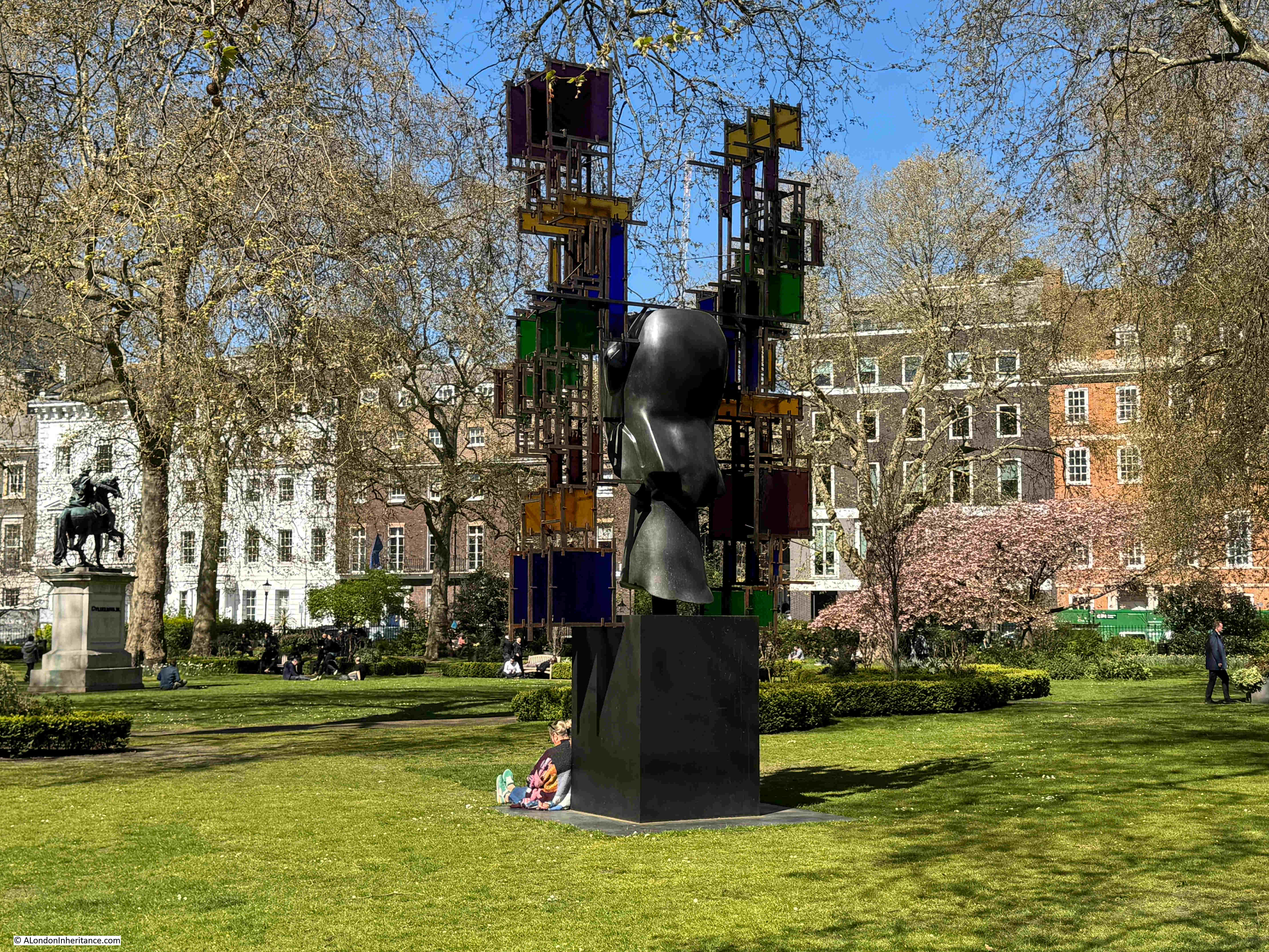
A couple of week’s ago, I was in St. James’s Square, where a combination of time of year, and weather contributed to one of those days where London is such a pleasure to walk and explore:
St. James’s Square was developed as part of the growth of Stuart London during the 17th century, when London was expanding westwards with the development of large estates in Piccadilly and St. James’s and eastwards through the developments of the East India Company in Wapping, Limehouse and Blackwall. St. James’s Square can be found almost half way between Piccadilly and Pall Mall.
The central gardens are an oasis of peace, away from the surrounding streets, including the street that surrounds the gardens which is packed with parked cars and vans, and traffic which appears to use one of five streets leading off from the square as a short cut, away from the main streets.
The gardens have a number of works of art, including the 1982 Leonardo da Vinci Monument (Vitruvian Man) by Enzo Plazzotta:
View looking north through the gardens. A small part of the church of St. James’s Piccadilly can be seen in the distance behind the statue:
I did not get the details of this work, which I think is relatively new:
View across the gardens from the north west:
In the centre of the gardens is a statue of William III, cast in bronze with the king dressed as a Roman General. The statue dates from 1807, so is much later than the original square, and it is a statue that was some years in the making, as the funding for the statue had been provided in 1724 by the will of Samuel Travers, and was reported in newspapers of the time as follows:
“Samuel Travers Esq. of Hitcham in Berks, member of Parliament for St. Maws in Cornwall, Auditor to the Prince, and Clerk to the King’s Works, and who dy’d, last Week, has left a Legacy of £500 to Prince William, as much to Lady Essex Roberts; Money for erecting a statue to King William in St. James’s Square or Cheapside Conduit”.
Samuel Travers must have been very rich for the time. As well as the above, he also left considerable sums of money to other beneficiaries, including £500 for “maintaining seven decayed Lieutenants at Sea”, as well as a considerable sum to Christ’s Hospital.
The statue of King William III, with the Theatre Royal, Haymarket in the distance:
The view of the statue with the theatre aligned with the centre of the gardens, along one of the streets which leads off the square, gives the impression that this was part of the design of the overall area, however the theatre was built after St. James’s Square had been completed, and when the square was built, there was a much narrower street leading into Haymarket, along with buildings that blocked the view. The view we see today is the result of later improvements to the surrounding streets.
View from the western entrance to the central gardens:
If you walk from Jermyn Street along Duke of York Street to get to St. James’s Square, there is a plaque on the walk at the corner of street and square that provides some background as to the origins of the square:
Henry Jermyn, the Earl of St. Albans (and who gave his name to Jermyn Street which runs between St. James’s Square and Piccadilly) has already started development of area based on his leasehold of land where Pall Mall is now to be found.
In 1665, King Charles II granted the freehold of the land now occupied by St. James’s Square and the surrounding streets, to Henry Jermyn, two years after he had petitioned the King for the grant of land.
In the following years there were issues with the exact area covered by the grant of land to Henry Jermyn, and the City of London objected to the development of an area that had been fields and lanes as all the new houses would be a competitor for limited supplies of water, however Henry Jermyn’s relationship with the Crown appears to have overcome any objections.
Initial plans for the development of the square included a symmetrical plan of four wide streets leading from the square at the centre of each side of the square. During development, this plan was modified with narrower streets to extend the amount of built space, and on the southern side of the square, rather than a single street to Pall Mall, two streets were built at the south east and south west corners. The use of two narrow streets on the southern side of the square was aimed at preventing the square from being a major route from Pall Mall up to Jermyn Street.
Development of the square commenced in the late 1660s, and by the time of William Morgan’s 1682 map of London, houses lined three sides of the square, with smaller buildings between the square and Pall Mall, as can be seen in the following extract from Morgan’s map:
The original layout of the square included a central area surrounded by low fencing, but early in the 18th century, the centre had been taken up by a large pond, as shown in Rocque’s 1746 map:
A 1720 print showing the original design of the square, with a street for coaches lining the four sides alongside the houses, and a central square for walking surrounded by a low fence:
The above print shows an ordered and tidy square, however there were ongoing issues with maintaining the cleanliness of the place, as described by Norman Brett-James in “The Growth of Stuart London” (London & Middlesex Archaeological Society 1935): “The condition of St. James’s Square left much to be desired, and Macaulay was not exaggerating when he describes the Square as ‘a receptacle for all the offal and cinders, for all the dead cats and dead dogs of Westminster. At one time cudgel play kept the ring there. At another an impudent squatter settled himself, and built a shed for rubbish under the windows in which the first magnates of the realm, Norfolk, Ormode, Kent and Pembroke, gave banquets and balls’ “.
To address issues with the square, in 1726 a Bill was put before the Commons to “enable the inhabitants of St. James’s Square to make a Rate on themselves, to clean, adorn and keep in repair the said Square”.
This improvement act appointed Trustees to care for and regulate the square, and their first meeting was held on the 23rd of June, 1726. This trust is still in place, and is the oldest Trust of its kind still operating in London.
The following 1754 print of St. James’s Square shows the central pond (a basin of water of 150 feet diameter), and if you look closely, to the left of the pond is a small boat with a man pushing the boat along with a stick and a woman sitting in the back of the boat – perhaps one of the most unusual features of a London square. There is also a small fountain in the centre:
One of the more unusual events held in a London square occurred on the night of the 9th of September, 1695, when a fire-work display was held in the square to celebrate “His Majesties Glorious success in taking of Namur” (Namur, in what is now Belgium, was taken by the French during the Nine Years war , and recaptured in 1695 after forces led by the Earl of Athlone surrounded the town).
A print of the event shows fireworks in the centre of St. James’s Square, which also appears to be surrounded by soldiers simultaneously firing their guns:
The statue of King William III from the time it was installed in St. James’s Square in 1807, in the centre of the basin of water, which was still occupying the central part of the square:
From the 1820s there was more planting around the square, and by the 1850s this was making the central water filled basin into a rather dark and dank place, so in 1854 the basin of water was filled in, and the gardens gradually assumed the shape and planting we see today.
The majority of the buildings surrounding the square date either from the 19th and 20th centuries, or are rebuilds or significant remodels of the original houses. An example is number 4 St. James’s Square, in the north east corner, which is Grade II* listed, and is a 1726 to 1728 rebuild of the original 1676 house built on the site by Nicholas Barbon, a significant property developer of London in the late 17th century, and responsible for many of the original houses in St. James’s Square:
On number 4 is a plaque recording that Nancy Astor lived in the house, she was the first woman to sit as a Member of Parliament:
In the photo of the corner of the square just above, there is a building to the left of number 4, with a flag flying above the entrance with the number 5. This building was the Libyan Embassy in 1984.
On the 17th of April, 1984, a demonstration by the Libyan National Salvation Front was held outside the Libyan Embassy, to protest about the execution of two students in Tripoli opposed to the Gaddafi regime.
Barriers had been erected to separate the protestors from the Embassy and from a separate protest by those who supported the regime.
During the protest, shots were fired by those in the Embassy at the anti-regime protestors, and one of the police officers on duty during the protest was hit, and died later the same morning.
The police officer was PC Yvonne Fletcher, and today there is a memorial to her at the place in St. James’s Square where she fell:
There is also a tree planted inside the gardens as a memorial to PC Yvonne Fletcher by the Trustees of the square, and her colleagues at Vine Street police station:
To the right of number 4 is number 3, a 20th century occupant of the square, dating from 1934, and designed by architects Alfred and David Ospalek:
Above the ground floor are a series of stone panels by Newbury Trent, which represent the street-criers of London:
On the corner of the south east street leading from the square down to Pall Mall is this brick Grade II listed house, and it is prime example of how houses have been modified over the centuries:
From its appearance, the house could date from the original build of the square, however the house dates from around 1772, so almost 100 years after St. James’s Square was laid out and built.
If you look at the house, there is the ground, then first and second floors, with a band of brick running around the walls above the second floor. This band marks the original start of the roof of the house as the upper two floors were added in the 1850s. London houses have had so many modifications over the centuries.
Many of the newer buildings around St. James’s Square occupy the space of more than one of the original houses, however there are some new builds which occupy the same plot of land as the original house. The only way to generate more floor space was to build up, resulting in tall, narrow buildings, such as these two, also at the south eastern corner of the square:
The western side of the square – the building on the left with the two flags is the East India Club, one of west London’s many private members clubs:
House along the northern side of the square:
If you look just above the roof of the Mini car in the above photo, there is a very small part of a blue plaque showing, this is to record that Ada Countess of Lovelace lived here:
Augusta Ada King was the only legitimate daughter of the poet, Lord Byron. She was eight when her father died, and perhaps typically of the time, the majority of the reports of her death focussed on her father, the following being one example:
“She had small resemblance to her father. No one, we are told, would have recognised the Byron features – the finely chiselled chin or the expressive lips or eyes of the poet – in the daughter. Yet at times the Byron blood was visible in her look – and those who saw her in 1835, on her marriage with Lord Lovelace fancied they saw more traces of the poet’s countenance in the bride than they remembered at any other time. But dissimilarity of look was not the only dissimilarity between Byron and his daughter. Lady Lovelace cared little about poetry”.
The report does acknowledge that “Her favourite science was the mathematical”, and indeed she does seem to have been a mathematical prodigy from an early age, and the reference to being a “Pioneer of Computing” on the plaque is down to her work with Charles Babbage and his “calculating machine”.
From notes that she kept, Ada appears to have been one of the first to recognise that a machine such as that built by Babbage, could be used for more than just as a calculating machine. With the appropriate algorithm, such a machine could carry out a wide and varied range of tasks – although I wonder if Ada could have imagined just how far computing and algorithms have been embedded into almost every aspect of life, 173 years after her death.
Ada Countess of Lovelace died of cancer at the tragically young age of 36. She is remembered still to this day with the programming language Ada being named after her.
Further along the northern side of the square, on the corner with Duke of York Street are two houses, both from 1736. On the left is the Grade I listed Chatham House, and on the right (without a door to the square) is the Grade II* listed number 9, which has its entrance in the street leading out of St. James’s Square:
Chatham House on the left is home to the organisation of the same name, dedicated to international affairs, and also the source of the term “Chatham House Rule”, a rule that states that what is revealed at confidential meetings can be used, but the identity of the person who spoke cannot be revealed.
The house has also been the home to three Prime Ministers, as this really nice London County Council plaque on the building reveals:
The house on the right is on the site of the house where Henry Jermyn, the Earl of St. Albans died.
The reason why I was in St. James’s Square was to visit the London Library, one of the institutes that I use for research, and which has a entrance in the north-west corner of the square:
The London Library was founded in 1841 and moved to its current location in 1845.
The single bay entrance is deceiving, as the London Library occupies a considerable area behind this one façade, stretching back and around to the right, along the side of the building to the right of the above photo.
The building is a bit of a maze (which is part of the pleasure), and in the following photo, the shelves on the left cover just part of their collection of books about London:
And in an area known as the “stacks”, you walk amongst shelves, along floors which look down to more shelves of books below:
A magical place.
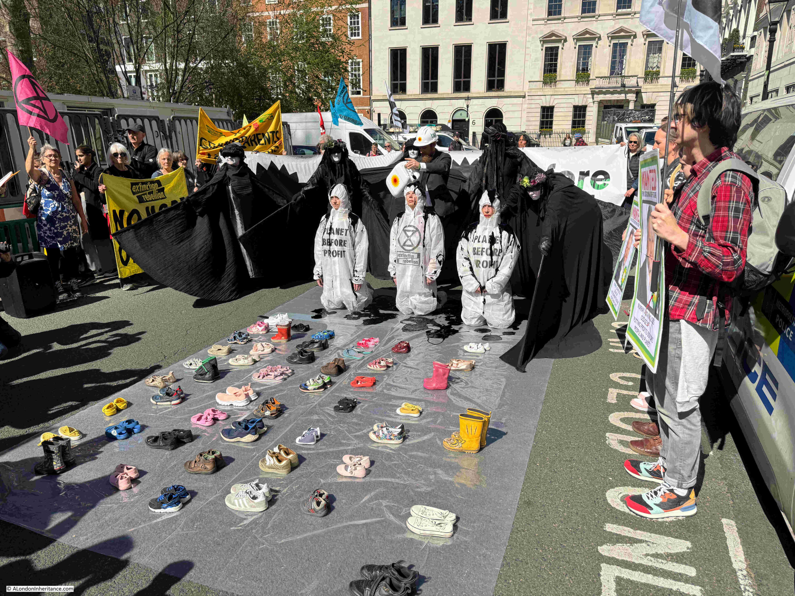
There is one more building in St. James’s Square which I have not mentioned, and on the day of my visit was to be a focal point for protest. The first indication of this was this small group within the gardens:
St. James’s Square is home to the registered office and worldwide headquarters of BP and Extinction Rebellion were holding a protest in the square, outside BP’s offices.
This started off with the north eastern section of the square being blocked:
BP’s offices:
Whatever your views of Extinction Rebellion, they have perfected a very theatrical method to get their message across, and are just one of many in the long running history of protest in London over very many centuries:
That is a very brief overview of St. James’s Square. A square that was part of the Stuart expansion of London during the late 17th century, as the city expanded into the surrounding fields.
A square that has been transformed over the centuries. Not just the central gardens, but also the new builds, rebuilds, and modifications of buildings surrounding the square, as the square changed from being the homes of the rich, aristocrats and well connected, to the home of international companies, institutes such as Chatham House, the London library, and a private members club.
A square that has been the home to many of those who were influential in their period of time, and a square that has seen protest, with one of these events resulting in the murder of a police officer by the representatives of a murderous regime.
Sitting in the central gardens on a glorious spring day, it was though intriguing to imagine the 1695 fireworks in the square to celebrate the victory at Namur, a display held on the edge of the growing city, and long before the use of gas or electric lighting, a very dark city.
Walk around the City of London today, and the majority of working buildings are those in use as office space. Today, there is very little, if any, small manufacturing industry in the City, although once the streets would have been full of small businesses, manufacturing a wide range of products.
This was not “dirty” industry, this was relegated to the south of the river, to the north, and particularly, to east London.
Despite the multiple phases of rebuilding in the City since the last war, there is one place where we can still see the ruins of the buildings that once supported multiple small manufacturing business, buildings that followed the alignment, and had their foundations built on the original Roman city wall, and where extensive Roman remains were found after wartime destruction – all in Noble Street:
Walk to the western end of Gresham Street, and the last street on the right, next to the church of St. Anne and St. Agnes is Noble Street. On the western side of the street, just past the church, are the ruins of a bombed building, as seen in the above photo.
A quick look behind the building reveals the old surrounds of the church, now almost impossible to access:
The ruined walls still retain a small part of the interior decoration:
Next to the above building, we can look north along Noble Street. A narrow City street, today with new office blocks along the eastern side, with the remains of more late 18th to early 20th century buildings along the west:
Which we can see by looking over the wall in the above photo, down into the gardens and brick walls:
The whole area within the above photo is a Scheduled Ancient Monument. The Historic England listing states that the area includes “buried remains of part of London Wall, the Roman and medieval defences of London, and part of the west side of Cripplegate fort. Remains of property walls of the late 18th-20th centuries built using the London Wall as their foundations are also included”.
To understand more about the remains here, I turned to my go-to book about post war excavations across the City – The Excavation of Roman and Mediaeval London by Professor W.F. Grimes. There is a good amount of details about Noble Street in the book, which he sums up as “This consists of the double Roman wall, still carrying in one place at its northern end a mediaeval fragment; an internal-turret of the fort; and the south-west angle, with its turret, the junction of the Aldersgate length of the city wall and the surrounding portion of Bastion 15. Final consolidation of these remains awaits completion of redevelopment schemes in the area.”
The mention of a fort in the above extract from the book refers to one of the earliest substantial Roman features in the City of London, a fort built at the north west corner of the City over what would become Cripplegate.
The Roman wall under the remains of the bombed buildings in Noble Street formed part of the western wall of this fort, dating from between AD 120 and 150, and later strengthened by building a new interior wall up against the original external wall, when the fort was incorporated within the late 2nd century City wall.
At the southern end of the Noble Street is a key feature which helped to confirm this, along with the changes in direction of the wall.
Grimes excavations found below the basement of number 34 Noble Street, the foundations of a “small sub-rectangular turret, built against the inner face of the wall on the crest of the curve. Taken in conjunction with the rest, it was immediately recognisable as the quite typical corner turret of a Roman fort”.
The curve refers to the way Grimes found the wall unexpectedly curve eastwards below the cellar of number 33, but on digging down in number 34, this was found to be the wall of the turret, and within number 34, the turret was found to be on the corner, where the wall then turned westwards to run to Aldersgate.
Looking down today, we can see part of the remains of this rectangular turret:
Grimes book includes a couple of photos of the excavations along Noble Street. The caption to the first reads “Noble Street, the junction of the fort wall (A) and the City wall (B) with the culvert through the later overlying the fort ditch. The fort wall can be seen approaching the modern wall in the background, is broken by a modern concrete foundation”:
Also in the book is the following photo, which was taken from a height looking down into the remains at the southern corner of Noble Street. The caption to the photo reads: “the south-west corner turret of the Roman fort, with, to right, the double wall curving towards it from the north and Roman city wall going westwards from it”:
Most of these remains have been covered up today, but are still below the surface – hence the status of a Scheduled Ancient Monument, and there are only small parts, such as the south west corner, where some of these remains can be seen.
The street is probably of a very considerable age, as it runs along the front of buildings constructed up against the wall, however the name is not (in London terms) that old. Henry Harben, in a Dictionary of London (1918) provides the following “First mention: On a tradesman’s token, 1659. Perhaps in early times Foster Lane extended further north than at present and included the present Noble Street. It may have been renamed ‘Noble’ Street after an owner or builder”.
As usual, with features many centuries old, much is speculation. The comment about Foster Lane does make sense, as Foster Lane and Noble Street were once a continuous street, before the construction of Gresham Street which cut across the two and made a clear separation.
William Morgan’s map of 1682 shows Noble Street as a continuation of Foster Lane in the south. Note that in 1682, the City wall is still a substantial feature to include in a map. The way the wall runs south, then turns to the west, as confirmed by Grimes, can clearly be seen. Also, in 1682, there is still an Aldersgate. This is not the original gate, but a 1618 rebuild of the earlier medieval gate. Aldersgate would not be demolished, and the street cleared until 1761:
There are a few numbered references along Noble Street. These are:
420 – Lillypot Lane
421 – Oat Lane
422 – Scriveners Hall
423 – Fitz Court
The entrance to Scriveners Hall, or as it was by the time of the print (1854) Coachmakers Hall:
The following extract from an Aldersgate Ward map from William Maitland’s Survey of London (1755) again shows Noble Street and Foster Lane:
The 1914 revision of the OS map shows Noble Street much as it must have been prior to wartime bombing, with the buildings shown along the western side of the street, which today can still be seen as ruins.
Fascinating that at the start of the 20th century, the alignment of the Roman fort and city wall can still be seen.
The wall continued north across Falcon Square, between Castle Street and Monkwell Street, where Grimes found more Roman and Medieval features, including the bastion shown on the map, and a second, hidden bastion. I wrote about this stretch of the wall in the post at this link.
Moving to the early 1950s, and we can see the considerable extent of wartime damage, with no buildings, and only a couple of ruins, shown along both sides of Noble Street. Much of this damage was caused by bombing during the night of the 29th December, 1940, when fires raged through the area surrounding and to the north of St. Paul’s Cathedral (Map ‘Reproduced with the permission of the National Library of Scotland“:
The remains of the buildings along the western edge of Noble Street were not even considered worthy of marking as ruins in the OS map:
There is a parish boundary marker on the rear wall of the above photo. The marker states that the boundary of the parish of St, Botolph, Aldersgate, extends 20 feet southward of this wall. I have always wondered where the plaque was originally located, as it is currently on the internal side of an east / west facing wall:
Many of the ruins are of quite substantial structures:
The title of the post referred to Noble Street and the ruins of London’s industry, and we can get a very comprehensive picture of this industry and commerce by looking at some of the old street directories of London, and the 1910 Post Office directory provides a listing from a time when all the ruins we see today, were in use, starting at the south east corner of the street:
In the above listing, we can see that at numbers 2 and 3 was the Post Office Tavern. In 1848 this was known as the Post Office Hotel, as in the Morning Advertiser on the 6th December, 1848 there was an advert for: “The Post-Office Hotel, Noble Street, Cheapside. The Valuable Lease And Goodwill. Mr. Daniel Cronin is instructed by the Assignees of Mr. Jasper Taylor, a Bankrupt, to Sell by Auction, at Garraway’s on Tuesday December 27th at 12, with possession of the above very excellent property, eligibly situate in the immediate vicinity of the busiest part of London, and constructed for the conduct of a first rate trade ion all its branches; held for an unexpired term of 34 years from Christmas 1848, at the low rent of £100 per annum”.
The directory starts from the south eastern side of the street, at the junction with Gresham Street. These directories usually list the street junctions, making is easy to work out the numbering and locations of businesses listed, and the directory does include those along the eastern edge – Lilypot Lane, Oat Lane and Fitchett’s Court, however the map does not state where Falcon Square to the north is reached, and the numbers start along the western side.
Fortunately, the details in W.F. Grimes account of excavations helps.
He wrote that the turret at the very south of the open space we see today, was found under number 34, with number 33 next to the north, so using the listing, we can see that in 1910, number 34 was occupied by:
Alex Strauss & Co – Millinery, ornaments
Hemken & MacGeagh – Manufacturers agents
Glasser & Co – Ladies belt manufacturers
I wonder if they ever realised they were working on top of a key junction of the old Roman fort / wall and a Roman turret?
The building adjacent, on the north of the one with the turret, was number 33, which was occupied by:
Egisto Landi – Confectioner
Frederick Rolinson – Lace agent
Hugh Sleigh & Co – Sewing silk manufacturer
Richard Chas Burr – Manufacturers agent
Joseph Johnson – Manufacturers agent
Victor Wolf – Manufacturers agent
M. Bloch & Co – Cape merchants
Albert Edward Hondra – Manufacturers agent
And continuing with the numbers as they head below 33 and 34, we can see the occupants of the ruins that continue north along Noble Street:
There are a number of common factors across the listing, which show how Noble Street was occupied during the first half of the 20th century (and almost certianly for much of the 19th century):
Many of the buildings were of multiple occupancy. Where we see a name with the title of Manufacturers Agent, we can imagine one person occupying a room, buying and selling the finished products from the street, or buying and selling the raw materials used in many of the manufacturing businesses.
Almost every building had a manufacturer of some type. These were small manufactures, mostly connected to the clothing trade, for example making gloves, handkerchiefs, hats, needles and pins. There was a “Galloon Manufacturer” at number 31 – a galloon was a heavily decorated woven or braided trim, so a product which would be used as part of a larger item of clothing
The number of businesses show how busy this relatively small street would have been in the first half of the 20th century. People coming and going to the buildings, raw materials and finished products being moved
The type of manufacturing shows how this area was so badly damaged by incendiary bombs during the night of the 29th of December 1940. Nearly every building would have been storing inflammable materials, and this type of industry was very common in the streets to the north of Gresham Street, including across what is now the Barbican. A fire would have taken hold, and spread very quickly. Even without bombing, fires were still frequent ( see my post on the Great Fire of Cripplegate ).
The listing concludes with the businesses from the corner of the present day southern end of the ruins, down to the junction with Gresham Street:
Noible Street had been a place of industry and manufacturing for many years before the above 1910 Post Office directory. The British Museum have a collection of trade cards from businesses within the street, and the following are a sample of these, starting with the following dating from around 1800, of Ashworth, Ellis, Wilson & Hawksleys, Silversmiths & Platers from Sheffield; who had their London Warehouse at 28 Noble Street:
Next is the trade card of Joseph May, an engraver who worked at number 4 Noble Street in the 1780s:
George Yardley was a carver and gilder in Noble Street in the mid 18th century:
Many of the Noble Street manufacturers resorted to some unusual methods to sell their products. For example, in January 1897, J. Scott of the City Umbrella Company at 1 Noble Street ran a competition for Valentines Day offering cash prizes to those who purchased umbrellas.
To qualify they first had to complete the following words by finding the missing letters. These were all examples of articles of daily foods in the late 1890s:
You then had to send your answer, along with an order for an umbrella to stand a chance of winning a first prize of £50, second prize of £25, 4th of £15 and 5th prize of £10. There was also a prize of £50 to the person who ordered the most number of umbrellas.
The individual winnings cannot have been much, as the prize money was divided across all the correct entries, so everyone who got the answers correct, and ordered an umbrella, received a share of the over prize.
Towards the north end of the ruins:
At the northern end of Noble Street, at the junction with London Wall (the area which was Falcon Square, and opposite the location of St. Olave, see this post from a couple of weeks ago) is a stretch of surviving ragstone medieval wall which stands up to 4.5 metres in height:
This medieval wall survives because it was incorporated into the structure of the building which stood on the site.
Looking back along the garden and ruins along the eastern side of Noble Street:
The ruins are silent now, but they do act as a reminder of the trades that once occupied so many streets across the City of London, when industry and manufacturing worked alongside commerce and office work.
Noble Street is also a p[lace which may have nurtured my interest in history, and London history in particular. When we were children, Noble Street was where my father parked when he drove up to London for a weekend walk, and I do remember peering over at the ruins as a child. Noble Street was the starting point for many walks across London.
In 1949, my father photographed the patrol boats of the Thames River Police, moored in the river next to the floating police station, which was located where the RNLI Lifeboat Station is today, next to Waterloo Bridge, which is the bridge seen in the background:
The boats of the river police, or to give them the correct name of today’s force, the Marine Policing Unit, have changed somewhat in the intervening 76 years:
The founding of the Thames River Police as a professional force goes back to the year 1800. The rapidly growing trade based along the river, the storage of valuable goods in warehouses and boats on the river and the resultant dramatic increase in theft resulted in an urgent need for a force that could protect commercial property.
Whilst a police force for the river had been formed in 1798, it lacked the supporting legislation, along with a more professional approach to policing, which the Port of London required.
One man, Patrick Colquhoun was instrumental in demonstrating the remarkable volume of theft, the commercial impact that this had, both on owners and the loss of tax revenue, and putting forward an argument for legislation to support a professional river police, and in 1800, he published a major work of some 676 pages with the title of “A Treatise on the Commerce and Police of the River Thames”:
It is a remarkable read, and before looking at the contents of the book, some back ground into the life of Patrick Colquhoun.
He was born in March 1745 and died at his house, 21 James Street, Buckingham Gate, in April 1820.
To try and find a detailed account of his life, I searched newspapers of the time to see if there was an obituary, however every paper published just a brief couple of lines, similar to the following from the New Times of London on the 3rd of May, 1820:
“On the 25th, at his house, No. 21 James-street, Buckingham-gate, Patrick Colquhoun, Esq. LL.D. aged 76. Author of the Treatises of the Police of the Metropolis and the River Thames, and of the Wealth, Power and Resources of the British Empire.”
I eventually found a very comprehensive story of his life in the Barbados Mercury and Bridgetown Gazette on the 26th of September, 1820:
“We lately intimated the death of our Countryman Patrick Colquhoun, and we should not have again referred to this painful subject had we not felt that his was no ordinary merit, and that it was in some measure our duty to bestow upon his memory our tribute of respect for the patriotism of his public life.
Mr Colquhoun was descended from an ancient family settled in Dumbartonshire for many centuries. A younger son, he proceeded to Virginia, and there, although in the wilds of America, having access to a valuable library, he, by his own industry, completed his education. Returning to Scotland, he established himself in Glasgow. For three successive years he was elected Lord Provost of that City.
He regulated and improved the Forth and Clyde Navigation, so beneficial to the internal commerce of the Island.
He removed to London, and was nominated a Police Magistrate, but his was not a disposition to confine itself to the routine of mere official studies; or, seeing evils and imperfections in a system, to object, find fault with them, and leave them as they were. He felt it his duty to suggest remedies, and, as far as the means were afforded him, practically to prove the utility of his suggestions; with this feeling, he published ‘The Police of the Metropolis’ and soon after his assistance was solicited by the Duke of Portland to systematise and superintend the marine police of the River Thames.
Mr. Secretary Dundas estimated the increase to the Revenue from the system established at £30,000 annually on sugar alone, by the prevention of depredations on that article, and so expressed it in his speech on introducing the Thames Police Bill into the House.”
There is more to the obituary, which I will come onto later in the post, however the above couple of paragraphs bring us to Colquhoun’s book.
He had already written about the Police of the Metropolis, and his next book, Police of the Thames, focuses on the problem of theft across the Port of London, policing of the river, quays and warehouses, and the Acts of Parliament, laws and penalties needed to address what was a significant and growing problem at the end of the 18th century.
Patrick Colquhoun was into detail. The book is full of the history of the Port of London, how it had arrived as one of the major global trading centres by the end of the 18th century, how the port operated, trade through the port, those who work across the port etc. and Colquhoun used plenty of data and statistics to support his proposed approach.
His book really provides a very in depth understanding of the Port of London at the end of the 18th century, and for today’s post, I will look at the first couple of chapters which provide some background to the operation of the port, and the different methods of theft of goods whilst in boats on the rivers, whilst being transferred, and when stored in warehouses.
Indeed, at every part of the chain from when a ship arrived at the Port, to the time when goods where shipped to their final destination, there was a risk of theft.
At the end of the 18th century, the City of London had already long been a trading port, for as well as being a major crossing between the north and south banks of the Thames, the city’s role as a trading port was key to London’s existence, importance and growth.
It was not only English merchants though who were responsible foe trade. Some of the first records of trade through the city, show that in 1561, there were no Englishmen who had a sole occupation as an importer and exporter. The 327 people who were recorded as being merchants, consisted of:
In the 16th century, England was somewhat behind other European countries, such as the Netherlands, Spain and Portugal (for example, in my post a couple of weeks ago on William Adams, when he arrived in Japan in 1600, the Portuguese and Spanish had already established trading links, and the Dutch were also trading in the region).
Much of the early trading through the City was driven by trading companies, and merchant adventurers, who raised the funds needed to buy or build ships, raise crews and trade across the world, and the 16th century saw a growing number of these companies:
Hamburg Company – one of the earliest. Granted a charter by Henry IV in 1406, and renewed through to 1661
The Russia Company – Charter granted by Queen Mary in 1555
The Eastland, or North-Sea Company – Charter granted by Elizabeth I in 1579
The Turkey Company – Charter granted by Elizabeth I in 1581
The East-India Company – Charter granted by Elizabeth I in 1599
The American Company – Charter granted by Charles II in 1663
The Hudsons-Bay Company – Charter granted by Charles II in 1681
The impact on trade by companies such as the East-India and Hudson’s Bay can be seen in how trade through the Port of London was switching between Foreign and British owned ships. The following table shows the change between 1702 and 1751:
It was not just trade with foreign countries that was creating the rapid rise in the volume of trade through the Port of London, there was also a considerable amount of coastal trade, with ships trading between London and the various ports around the coast of the country.
The following table is one of very many from the book and shows the type of detailed information on the Port of London used by Colquhoun. The table shows the Coasting Trade between the Port of London and the ports across England and Wales in 1796:
The following table shows the increase in foreign trade throughout the 18th century, and the mix between British and Foreign ships. The table shows that foreign shipping expanded considerably during the later half of the century compared to the first half:
All these ships transported a vast array of valuable goods, and the book includes a large, fold out table detailing “Commerce and Shipping of the River Thames…..applicable to the year ending the 5th January 1798, with the true Valuation of the Merchandise Imported and Exported from and to Parts beyond Seas”. It was difficult to photograph this table due to the delicacy of this 225 year old book, and really not wanting to damage my copy. The following is my best attempt, click on the image for an enlarged version:
This was a colossal volume and variety of goods that at some point were on a ship in the Port of London, transferred between ship and quay, and stored in w warehouse.
I used the Bank of England inflation calculator to see what the equivalent value would be today, and the £30,957,421 of Imports would today be worth £3,375,071,706, with the £29,640,568 of exports being worth £3,231,504,408.
A number of caveats need to apply to these figures, for example the accuracy of inflation figures going back over 200 years, purchasing power, etc. but they do give an idea of value, and in today’s money, in 1798, £6,606,576,114 was being imported and exported through the Port of London
All these figures on trade in the Port of London were included in Colquhoun’s book to indicate the scale of the problem, as this vast array of valuable goods offered a considerable opportunity for theft, both by “professional” thieves, as well as organised and petty pilfering from those who worked across the Port of London.
Patrick Colquhoun believed that theft was endemic.
He believed that theft became a significant problem after the start of the 18th century, and attributes this to a decree of religious and moral decay, described in the following paragraphs:
“The progress of evil; propensities was slow, while a sense of Religion and Morality operated in a greater degree than at present; upon the minds of the lower orders of people. In the moral, as in the physical World. The change of habit is gradual, and often imperceptible. In contemplating the magnitude of the abuses which are to be developed in this Work, the mind is naturally led to an inquiry into the causes which have produced a system of matured delinquency; which is perhaps, unparalleled in the criminal history of any other country.
It is not unlikely, that the disposition to pillage Commercial Property while afloat, derived its origins in no considerable degree, from the habit of Smuggling, which has prevailed ever since Revenues were collected.”
Colquhoun treated the propensity for theft as a disease, which contaminated the minds of those working on the river. Those infected were seduced by motives of avarice, habits of pillage, and an impunity that came with the lack of appropriate laws, and the force to carry them out.
In describing how the disease spread, he states that: “New Converts to the System of Iniquity were rapidly made. The mass of Labourers on the River became gradually contaminated. A similar class upon the Quays, and in the Warehouses, caught the infection, and the evil expanded as Commerce increased.”
Colquhoun’s book provides very many detailed descriptions of daily life in the Port of London, and of those involved in the very many types of illegal activity in the port. These descriptions help us to understand what it was like in the Port, and the dangers faced by those transporting goods.
Colquhoun identified a number of “species of Depredation”, or “Classes” of those involved in theft across the Port of London, and I have summarised his descriptions of these as follows:
River Piracy – This was where organised gangs would attack a ship or lighter, and would take almost everything on board. Methods included cutting the anchor ropes or chains and letting the ship drift to a more suitable part of the river where it could be stripped, not just of cargo, but also of rigging, ropes, anchors, cables, anything that could be moved and had a value.
Night Plunderers – These were “chiefly composed of gangs of the most dissolute Watermen, who prefer idleness to labour”. Night plunders would look for, of be informed of, unattended lighters on the river, and would steal anything that was accessible and portable from the lighter. They would then take their plunder to a place agreed with a Receiver (another of the many criminal roles across the Port). Night plunders would often steal from the same place over a period of time, and Colquhoun gives an example of five boat loads of Hemp being stolen from a lighter over the course of a few weeks, and conveyed along the river, through London Bridge to Ranelaigh Creek where the stolen Hemp was sold.
Night Plunderers. denominated Light-Horsemen – Light-Horsemen were a type of Night Plunderer that focused on the West India Trade. Their pillage was “generally extensive and valuable”. They were organised, with Receivers on both sides of the river who were the chief leaders of individual gangs, The gangs of Light-Horsemen consisted of one or more Receivers, Coopers, Watermen and Lumpers, and they would board a boat fully prepared with Iron-crows, Adzes and the tools needed to open casks and shovels to take out Sugar. The Watermen procured as many boats as were needed, the Lumpers unstowed the casks in the hold and the Coopers took of the heads of the casks, and all hands assisted with filling bags and loading into their boats.
Heavy-Horsemen or Day Plunderer – These criminals would pilfer whatever they could from a ship or lighter, often while working on the transfer of cargo. They would often use an undergarment, called a “Jemmy, with pockets before and behind; also with long narrow bags or pouches, which, when filled were lashed to their legs and thighs, and concealed under wide trousers”. They would carry off vast amounts of Sugars, Coffee, Cocoa, Ginger, and Colquhoun quotes one instance where s single gang stole enough sugar, that, despite being sold for half of its actual value, made them £397.
Journeymen Coopers – These workers were employed to repair casks and packages, but in reality many used this work to thieve. For example, when leaving ships in the evening after a day of proper work, they would carry off Sugar, Coffee, and any other articles or goods that were easy to conceal and carry.
Watermen – For theft across the river, a boat would be needed, and unscrupulous Watermen would often provide the boats needed, and take those intent on stealing to their targets on the river. They would keep watch, and afterwards take the gangs and their stolen goods back to shore, and they would receive a payment for their services. Colquhoun provides an example of how a Waterman would work – “A Ship-Master who had been a stranger in the river, finding himself beset by a gang of audacious Lumpers, who insisted on carrying away Plunder in spite of all his exertions to prevent it, while he was engaged on deck in searching these miscreants, a barrel of Sugar which stood in his Cabin was in the course of a few minutes, emptied and removed in bags through the cabin windows, under which a Waterman with his boat lay to receive it, and got clear off without discovery, to the surprise of the Captain when he returned to his cabin.”
Mud-Larks – Where a vessel close to shore was being looted, the Mud-Lark would prowl about in the mud, under the Bow and would receive bags from those on board the vessel, and would carry the bags to shore. Mud-Larks would also prowl around Dock-Gates on the pretext of looking for nails, where their principal object was to receive sheets of Copper and bags of Nails which were thrown to them by dock labourers.
Rat-Catchers – Ships would often be infested with rats, so a Rat-Catcher would provide a valuable service, however many rat-catchers used their work to steal from ships. Rat-Catchers would often work at night to set traps, and at the same time take some of the cargo. They would also revisit the ship whenever they wanted on the pretext of checking and resetting the traps, but again used these opportunities to steal. Rat-catchers were also known to transfer live rats between ships in order to get more business, and to use the opportunity to steal from other ships.
Game-Lightermen – This class of criminal consisted of Lightermen who would steal from the lighters on which they worked. Lighters were used to transfer cargo between ship and land, and between ships, so for a period of time the cargo carried was under the control of one or more Lightermen, who would use the opportunity to take a proportion of the cargo being transferred. Much of this stolen cargo was transferred to a small boat, or skiff, and Colquhoun provides an example of a seizure of a Skiff loaded with a bag of Coffee and 109lb of Sugar whilst in the act of being stolen from a Lighter.
Scuffle-Hunters – These are described by Colquhoun as “literally the lowest class of the community, who are vulgarly denominated the Tag-Rag and Bobtail”. Scuffle-Hunters would hang around the places where goods are being landed on the Quays, and offer assistance as a porter. They would wear long aprons, which allowed them to conceal any goods that they could take, whilst apparently helping the loading or unloading of a ship.
The Warehouses – Whilst Colquhourn does not list a specific name for those who stole from warehouses, he does include warehouses in the list as a place from where individuals or gangs would steal. This included those who specifically entered a warehouse at anytime, day or night, with the intention to steal, as well as those who worked in a warehouse and used the opportunity to pilfer goods.
Based on the above descriptions, it seems amazing that any of the goods traded through the Port of London survived the process, and did not end up in the hands of a Receiver, however even if 5% of traded goods ended up as being stolen, this would still be a value of just over £3 Million in 1798 prices, being stolen every year.
The descriptions help us to understand what life was like on the river, and along the Quays where goods were being loaded and unloaded. It was a place where ship and cargo owners must have been forever on their guard, where boats with a gang of men passing along the river would have been viewed with suspicion by those on ships, and where many of the shops of London sold stolen goods.
As an example of how stolen goods were traded on, Colquhoun gives an example of Thames Street.
Today Thames Street (now Upper and Lower Thames Street) is a much widened street with dual carriageways taking traffic between the eastern and western sides of the City.
In the late 18th century, Thames Street ran along the back of the warehouses and quays that lined the river, and as with most of London at the time, there were many Pubs both along Thames Street and in the surrounding streets.
It was in these Pubs that stolen goods were sold. Journeymen Coopers would take their Boards of Sugar, and small Grocers would purchase this sugar with fictious Bills of Parcels used to cover the transfer of stolen property from the Pubs to their shops and houses.
Print from 1801, the year after Colquhoun’s book was published, showing the Thames, busy with shipping:
There is too much in Colquhourn’s book to cover in a single post, so I will explore the Port of London and Policing the Port in more detail in the coming months, but for now I return to the obituary published a few months after his death, to provide a summary of his other achievements:
He established a society at Lloyd’s, with some of the most respectable merchants, to assist the poor and the needy by the distribution of soup, potatoes, herrings etc.
In 1806, he proposed the establishment of Savings Banks “to lead the poor by gentle and practicable means into the way of bettering themselves”
He was “so highly esteemed in the dominions of His Majesty, as on the Continent of Europe, that the colonies of St. Vincent, Nevis, Dominica and the Virgin Islands, as also the Free Hanseatic Republics of Lubec, Bremen and Hamburg, nominated him their Representative and Consul General”
As well as his two books on policing, he also published a book on the “Power, Wealth, and Resources, of the British Empire”, along with other publications on Criminal Justice, Political Economy, and on Commerce and Manufacture of Great Britain
He was one of the first five who met and formed the Royal Institution (this was the meeting on the 7 March 1799 at the Soho Square house of Joseph Banks. I can not immediately find any confirmation of this)
He was a Member of the Society for bettering the condition of the Poor
The University of Glasgow conferred the distinction of Doctor of Law, and he was granted the Freedom of the City of Edinburgh
The obituary ended with a summary that he had “a mind fertile in conception, kind and benevolent in disposition, and bold and persevering in execution; ever ready to give his advice and assistance when his means enabled him to do so, and that his long and laborious life was honourable to himself and useful to his Country”.
There were some criticisms of his approach, that he was too much on the side of Commerce and Capitalism. His view on the poor also seems to have followed the 19th century view of the “deserving poor”, as Colquhoun in some of his publications appears to divide the poor into those who deserve help, and the criminal poor, who only deserve the full force of the law, and this can be seen earlier in the post with his use of “species of Depredation”, or “Classes”.
His book on the Commerce and Police of the River Thames does provide us with a very comprehensive view of the Port of London, at the end of the 18th century, a time when the London Docks were about to enter a period of rapid expansion.
I will explore this brief period of London’s history in more detail, using Colquhoun’s book in future posts.
The area between the Strand and the Embankment is a fascinating place to explore. There are plenty of small streets and alleys, many running between the Strand and Embankment, others linking between many of these streets. Those that run down to the Embankment can be (for central London) relatively steep, with a number having steps up to the Strand – a reminder of how this area was once the steep bank between the foreshore of the Thames, and the high ground along which the Strand became part of a well travelled route linking the City of London and Westminster.
The area was also once the home of the great London homes of the rich and titled, estates such as Arundel House, York House, Essex House and Northumberland House.
As with most of London, continuous redevelopment has transformed the streets and buildings, perhaps the most significant being the construction of the Embankment and Embankment Gardens which now provide an expanse of flat land between what was the boundary between land and river, and the Thames of today.
The descent from the Strand down to the river needed some creative construction techniques for many of the large estates and buildings, and one of these was the late 18th century Adelphi development by Robert Adam.
Located where the 1930s Adelphi now stands, Roberts Adam’s original Adelphi was a development of streets and houses on a level platform to bring the estate up to, as close as possible, a level with the Strand.
To level up the Adelphi development, it was built on a complex of arches that created an area below the houses that was intended to be rented out for storage, stabling, warehouses for the wharf between the Adelphi and the river, etc.
There is almost nothing left of this dark and damp subterranean area following the development of the existing Adelphi building, however the following mid 19th century print by John Wykeham Archer gives an impression of what these vaults were like:
One place we can get feel for what it was like to walk down into the vaults under the Adelphi, is in the street York Buildings, where towards the upper part of the street, there is an entrance under a 20th century building, into Lower Robert Street:
Much has been written about Lower Robert Street, about its eerie atmosphere, and the story that it apparently even has a ghost, but in today’s post I will be concentrating on the history and architecture of the place, what it was like when the Adelphi was built, and the difficulty of showing Lower Robert Street on a map, although there is also a very tragic story that could have been the source of the ghost story.
When we walk into Lower Robert Street via the entrance shown in the above photo, we are walking under a 20th century building, and when the Adelphi was built, this was through an open gap at the end of a terrace of houses.
After passing under the later building, we get to the original, late 18th century stretch of the street, where it passes under the rear of one of the terrace buildings that line Robert Street above:
In the above photo, you can see the cheap approach to building this side of the buildings. The rear of the terrace was not meant to be on public display. It was not facing onto a street, and if you had business in the house (apart from those who were servants or workers), you would access the house from the front, on Robert Street.
The photo below shows the terrace of houses in Robert Street that the tunnel passes under, and shows the fine front of these buildings, Good brick work and decoration, compare with the cheap finish of the rear of the buildings:
Horwood’s 1799 map of London shows the area soon after the completion of the Adelphi.
In the following extract, the Adelphi is the rectangular block of terrace houses between Royal Adelphi Terrace and John Street (now John Adam Street), and to the left of the Adelphi, we can see Robert Street, and continuing to the left is George Street (now York Buildings):
In the above extract, the arrow points to the entrance in George Street / York Buildings to what is now Lower Robert Street, and as can be seen, this was an open entrance at the northern end of a terrace of houses, and that led into what appears to be a narrow, open space between the buildings in George Street and Robert Street – probably for service access to the buildings – a space that is open at its southern end.
Although not marked on the map, I assume that the length of tunnel underneath the house on Robert Street was there at the time, as the house is of the time of the Adelphi, and it would not have made much sense to build the tunnel at a later date.
I have marked the route of the tunnel and current route down to the south of the Adelphi with the red line in the above map.
This routing shows the source of the name as Lower Robert Street as part of the route runs below Robert Street.
A possible error in a map leads to an intriguing possibility.
I use OpenStreetMap as a source of maps for the blog, as they can be reproduced on non-commercial sites, and when checking OpenStreetMap for the area around the Adelphi, I found that it shows the route of Lower Robert Street mirroring the open space in the 1799 Horwood map, all the way down to the gap between rows of buildings at the southern end.
There was once very limited access between the two rows of buildings along the line of what is shown as Lower Robert Street in the above map, however it was not a street as implied by the map, and today is closed off at both ends.
If we follow the old part of the tunnel under the buildings on Robert Street, we can see the bright lights of the loading bay for the Adelphi at the end:
I assume that instead of the loading bay, the tunnel of Lower Robert Street provided access to the vaults underneath the Adelphi, and the view would have been of a series of arches, vaults and dark space running off into the distance.
We can get an impression of the area around Little Robert Street by looking at mentions in old newspapers, and the following dates from 1774, listing the prizes of the lottery held to raise finance for the construction of the Adelphi, where winners received houses or vaults:
A double vault for coach-house and stable with hay loft and servants rooms, over, on the north side of the Mews Street, situate between Lower Adam Street, and Lower Robert Street, being the first west from Lower Adam Street, which is let on and in occupation by Mr William Adam, Mr Capel, and Mess. Hodgson & Co. tenants at will at £34, 13s per annum.
A vault on the north side of Lower John Street westward of the vault facing Lower Robert Street. Ground rent 7s 6d per annum.
Note that as well as Lower Robert Street, the list mentions Lower Adam Street and Lower John Street, so there must have been a network of subterranean streets, with names mirroring the streets above.
We can get an idea of the size of the vaults and the uses to which they were put, from the following advert of leaseholds for sale in the Morning Herald on the 22nd of March, 1819:
“Numerous spacious Warehouses and Vaults, seven coach houses, stables for 50 horses, and other extensive and improvable premises, situate in Robert-street, Lower Adam-street, Lower Robert-street, Mews-street, Durham Street and under the Arcade, all in the Adelphi”
The rent obtainable from the above premises, which were already let, amounted to £448 8s per annum.
There is not much further mention of Lower Robert Street, or the vaults under the Adelphi. The build of the Embankment would later cut off the Adelphi from the Thames, so there was no opportunity to use the space for storing goods transported by river, and when there was an attempt to sell the vaults, warehouses, and houses around and under the Adelphi, they would not sell, perhaps indicative of the condition of the estate, certainly of the vaults below.
The record of the auction, from the London Daily Chronicle on the 22nd of June, 1927, includes Lower Robert Street within Lot 1, which compriosed:
“The freehold island block, Adelphi Terrace, including Nos. 1 to 10, John Street, 5 and 6 Robert Street, 19 Adam Street, the Adelphi foreground, with the lofty vaults and arches, embracing buildings in Adelphi Arches, Adelphi Cottages, Lower Robert Street, Lower Adam Street, part of Durham Hill, and ‘Jenny’s Hole’, together with soil of the subterranean private roads”
The contents of Lot 1 include some interesti8ng references. Firstly the “subterranean private roads” confirms that there was a network of streets below the Adelphi, which must have provided access to the vaults and warehouses below ground.
Secondly the reference to “Jenny’s Hole”.
There are a number of references to “Jenny’s Hole” the first is from Thackers Overland News on the 25th of March 1858, where:
“The notorious Adelphi arches will, it is expected, shortly cease to afford shelter to the helpless outcasts of London. They are in gradual process of letting. The most fearful den among them, one upon which had been bestowed the title of ‘Jenny’s Hole’ was taken a short time since by a publican for a wine-cellar”
The above article hints at the state of the area underneath the Adelphi, and the following report from Lloyds Weekly Newspaper on the 19th of September, 1852, paints an even darker picture, both of the area below the Adelphi, and of the tragic conditions that children could get into in 19th century London. It is a long and harrowing read:
“YOUTHFUL PROSTITUION AND DEATH – On Friday, Mr Langham, the deputy coroner for Westminster, held a lengthy inquiry at the St. Martin’s Workhouse, touching the death of Mary Ann Palmer, aged fifteen years, which occurred on Tuesday last at the workhouse, having been brought there by the police, who found here on the previous Sunday in a frightful state of disease and destitution, under the dark arches of the Adelphi in the Strand.
The case was one of these harrowing details exhibiting the horrible extent of juvenile prostitution in the metropolis, the bare recital of which appals the mind.
Sarah Cunningham, a girl only eighteen years of age, but whose appearance indicated the rapid course to an early grave, said that she had been fatherless and motherless since she was nine years old, having from that period got her livelihood on the streets, with the exception of about three months when she had a place shortly after her parents’ death (the jury shuddered as they looked upon the girl).
She formed an acquaintance with the deceased about eighteen months ago, since which time they had been companions up to her death.
The deceased and witness used to frequent an unoccupied stable, under the dark arches of the Adelphi, and a place also known as Jenny’s Hole down there from about half-past eight in the morning until nine at night, as they were too dirty and ragged to walk the streets, and they used to be visited by the young men working about the place, as also those passing to and fro by the halfpenny steamboats.
The police used to visit the place frequently, both day and night, but they were eluded, as the various girls went and hid, or left the place by another opening, returning again as soon as the constables had gone by.
The deceased was following her late course of life when the witness first met her, which was one evening at the Victoria theatre. The young men at the stables used to give them something to eat, and help to screen them from the police. They got no other money, but what they obtained under the arches in the way stated.
Deceased was very bad and had been in hospital twice. Witness had heard her say that she had a good home to go to – In answer to the coroner, witness stated that she would be glad to do anything that would take her off the streets.
Policeman Joseph Kelly, 137 F, said he found the deceased in ‘Jenny’s Hole’ on Sunday week last. She was lying down in a very bad state, being exceedingly filthy and loathsome in the extreme, labouring under a complication of diseases, and being covered in sores and vermin. Everything that could be done was done for her at the workhouse, but she died about four o’clock on Tuesday morning, the immediate cause being dropsy.
The father of the deceased said that she had been enticed from home nearly two years ago. He had spared no money on her education, and the last time he saw her alive was in November, when he had her home from the hospital and cleansed, but she soon went away again. She was his only child.
A verdict of ‘Natural Death’ was taken, and the coroner and jury sent the girl Cunningham to St. Mary’s workhouse, Lambeth, that being her father’s parish, and if she was not taken in, Mr. Testall, the master of St. Martin’s would receive her until her proper settlement was ascertained.”
A dreadful story, and one that tells much about being poor and at risk in London in the mid 19th century. The comment about whether the workhouse in Lambeth would accept Sarah Cunningham, was probably down to the common problem of lack of money, and a parish workhouse not wanting to take people from outside the parish, or seek more funds from those in the parish.
In many of the stories and accounts of Lower Robert Street on the Internet, there are references to Poor Jenny being a prostitute murdered by a client, and it is her screams that still haunt Lower Robert Street, and presumably where the name Jenny’s Hole came from.
The list of hauntings in London at this link, claims that Jenny was a prostitute murdered in 1875, and presumably is the source of the name Jenny’s Hole, however as can be seen in the above articles from 1852 and 1858, Jenny’s Hole was in use almost 25 years before the supposed murdered prostitute of the same name.
I cannot find the source of the name “Jenny’s Hole”, however I do find the tales of the haunting of Lower Robert Street a rather glib dismissal of the appalling and tragic conditions that young girls such as Mary Ann Palmer and Sarah Cunningham could find themselves in. and the way they were treated and abused.
At the bottom of the old tunnel of Lower Robert Street, looking back up in the direction of the entrance at York Buildings:
In the above photo, the Adelphi loading bay was behind me, and when I turned to the left, I could now look along the route of what may have been Lower Robert Street, and which is now part of the underground car park of the redeveloped Adelphi:
Which then leads to the exit onto Savoy Place – the street that runs between the Adelphi and Embankment Gardens. The exit / entrance can be seen to the left of the following photo:
In the following print of the original Adam’s development of the Adelphi, the entrance can be seen to the far left of the run of arches that faced from the vaults onto the foreshore of the Thames:
I am still unsure of the full route of Lower Robert Street. There is only a very small part of the original structure remaining, where it passes under the terrace house on Robert Street.
Did it then turn right and head to the river side of the Adelphi? Was it an actual street, or more probably just an access route from the street to the west of the Adelphi that ran alongside the western edge of the vaults under the Adelphi to exist to the south.
The fact that there was also a Lower Adam Street (mirroring Adam Street on the east of the Adelphi) and Lower John Street (mirroring John Street to the north of the Adelphi, implies that there were three subterranean streets running along each of the western, northern and eastern sides of the vaults, with the southern side looking straight through the arches on to the Thames foreshore.
Whatever the source of the name Jenny’s Hole (it probably refers to a previous occupant of this small place, possibly an alcove within the vaults), it was where fifteen year old Mary Ann Palmer was found, and soon after died, and her death tells an important story of the tragic circumstances that children could find themselves in, in 19th century London.
And the small stretch of Lower Robert Street is the only surviving part of the subterranean environment beneath the Adelphi that she would recognise today.
There are a number of options for the centre of London, almost all dependent on how you define the centre of a city such as London. For today’s post, I am going to go for the Bank Junction as the historic centre of London – that point where several key roads meet in the City, in front of the Bank of England, Royal Exchange and Mansion House, which until recently, has been a place busy with traffic and people, as this image from the late 19th century illustrates, looking across from outside the Mansion House to the Royal Exchange, when it was described as “The open space bounded by the Exchange, the Bank, and the Mansion House is perhaps the busiest in all the City:
And it was much the same in the 1920s, although there are some subtle differences, including the war memorial that now stands in front of the Royal Exchange as the photo below was taken not that long after the First World War:
This is a very old part of the City, once at the heart of the Roman City, with very many Roman remains having been found deep below the current surface level.
The 16th century “Agas” map shows the key streets of Cornhill, what is now Threadneedle Street, and Poultry, and by the 1682 map of William Morgan, we can see the area around the Bank junction (which is slightly left of centre in the following extract), with the second iteration of the Royal Exchange (after the first was lost during the Great Fire of 1666), and where Poultry and Cornhill meet, we can see the Wool Church Market, at the site of the future Mansion House (see this post on St Mary Woolchurch, and the wool market):
By the time of Rocque’s 1746 map, we can see that the Wool Market has now been replaced by the Mansion House, and the first building of the Bank of England is shown in Threadneedle Street, simply labelled as “The Bank”:
By Horwood’s map of 1799, we can see how the rapid expansion of the Bank of England has taken up so much space between Threadneedle Street and Throgmorton Street:
In all the above maps, there are only four streets converging on the Bank junction – Cornhill, Lombard Street, Poultry and Threadneedle Street. The junction would get far more complex with the “improvements” to the City implemented by the Victorians during the 19th century, which would leave us with the junction we see today in the centre of the following map:
Where we can now see that Queen Victoria Street joins the junction via Poultry, King William Street has been built, with Lombard Street now joining the junction via this new street, and finally Princes Street, which was widened and straightened along the western side of the enlarged Bank of England.
And this was why the Bank junction was so busy. Cornhill to Poultry and Cheapside was for long a significant east – west route. The new Princes Street and King William Street added a north – south route to London Bridge, and Queen Victoria Street provided a direct route down to Blackfriars Bridge along with the Embankment route to Westminster.
To these through routes was added all the local traffic to the offices, shops and businesses across the City of London.
The geology of the area is one of the reasons why the City was established where it is. In the following extract from the brilliant topographic-map.com, the height of the land across the City is colour coded so that the blue / greens represent decreasing height and yellow to red indicates increasing height:
We can see the Bank junction just to the lower right of the centre of the map, and Cornhill is a hill that runs up to the highest land just to the right of Leadenhall Market.
The higher land around and to the right of the Bank junction is not as pronounced today as it was many centuries ago. Building and street levelling over the centuries has resulted in higher ground being much less pronounced, and originally, the land at and to the right of the Bank was one of the two main hills of the City, with the other being around St. Paul’s Cathedral, before the drop down to the Fleet River.
One of the City’s lost rivers, the River Walbrook once flowed slightly to the west of the Bank junction, cutting across where Queen Victoria Street, Poultry and Princes Street now run, at a much lower level to the current street surface.
Bank junction today, looking across to the Royal Exchange, with the Bank of England on the left:
There are two main differences between the view across the junction of today, and that of the recent past.
Firstly, and most obviously, are the tower blocks in the background. Secondly it is the lack of road traffic.
Over recent few years, the City of London Corporation have been restricting vehicle access across the City, and the impact of this can be plainly seen at the Bank. The part of Threadneedle Street to the left of the Royal Exchange has been pedestrianised, and the complex restrictions are summarised in the following extract from the City of London’s website:
I have mentioned this before, but whilst these restrictions have resulted in a much more pleasant place to walk, better air quality, and providing an environment where it is much easier to see the buildings surrounding the junction – it does leave this central part of the City lacking a sense or urgency and activity, of a vibrant and thriving place. It is probably though just the change from the City that I knew for many decades.
Apart from the new Victorian streets, the layout of the Bank junction has not changed that much, just the buildings that line the streets.
This was the view from outside Mansion House, looking across to the Royal Exchange in 1804, where the open space we see today in front of the Royal Exchange, was then occupied by Bank Buildings. The Bank of England is on the left and the tower of the version of the Royal Exchange rebuilt after the Great Fire is on the right:
So there has been major rebuilding of the buildings that surround the junction, but the layout of the junction has remained much the same for centuries, with the addition of new streets in the 19th century.
The times when the actual junction has needed a rebuild is when the Bank underground station arrived, and when the junction, and the station below, was seriously damaged by a bomb on the night of the 11th January, 1941, when the bomb went through the road surface and exploded in the booking hall of the station, as illustrated in the following photo:
Many of those in the station at the time where sheltering, and the bomb caused the death of 56 people, with many more being injured, and today there is a plaque in the station recording the event:
Time for a walk around, to look at the streets and the buildings that surround the junction, starting with the streets. In the following photo is the Royal Exchange, and Cornhill is the street leading of to the right of the photo:
Cornhill is an old street, and one of the principal streets of the City. The earliest written record of the street dates from around 1125 when it was recorded as Cornhilla.
The “hill” element of the name is due to the street running up the western slope of the hill that peaks north-east of Leadenhall Market and “Corn” comes from the association with a corn market that was “held here time out of mind”, as recorded by Stow.
In the following photo is Princes Street, running along the western edge of the Bank of England:
An earlier Princes Street can be seen in the 18th century maps shown earlier in the post, however the Princes Street we see today has been straightened with the loss of a northern section, by the 19th century extension of the Bank of England.
In the following photo, the red bus is in Poultry, which is the street leading west out of the junction:
Poultry is another old street, with first mentions being in the 12th and 13th centuries. The name comes from the markets that were held here where poulters sold their produce.
In the above photo, the River Walbrook once ran across the street, in front of the new building in the centre of the view, the Grade II* listed No 1 Poultry, designed by James Stirling in the 1980s, although the building was not completed until 1997.
The photo shows how much land levels have changed over the centuries, as today there is no sign of the small valley in which the Walbrook ran, which was well below the current level of the street surface, which can be seen by a visit to the Temple of Mithras, now on display at the London Mithraeum, built as part of the construction of Bloomberg’s new European headquarters, a short distance to the south.
A slightly different view, with Queen Victoria Street running to the left of the new building:
Queen Victoria Street was built to help with the growing levels of traffic in the City, and to provide a direct route from the Bank junction, down to Blackfriars Bridge, and the new Embankment.
Construction was recommended in 1861 and included in the Metropolitan Improvement Act of 1863. The new street opened in 1871.
The new street resulted in the loss of numerous courts and alleys, as well as streets of a larger extent, which were swept away for its formation. Amongst those which had occupied the site of the new street were Five Foot Lane, Dove Court, Old Fish Street Hill, Lambeth Hill (part), Bennet’s Hill (part), St Peter’s Hill (part), Earl Street, Bristol Street, White Bear Alley and White Horse Court.
To the left of the above photos is Mansion House:
A permanent building for the official residence of the Lord Mayor of the City of London was one of the considerations for rebuilding the City after the Great Fire, however these plans were not realised until the 18th century.
The site of the old market was appropriate as it was located at a junction of important streets, which did not have any significant monuments.
The architect was George Dance the Elder, who at the time was the City of London’s Clerk of Works. and who took on the challenge of designing a building fit for the Lord Mayor of a growing City and which was able to accommodate both ceremonial functions as well as providing rooms for a private residence.
Work started in 1739, with completion in 1758, and the first Lord Mayor to take up residence was Sir Crispin Gascoigne.
The main reception room was (and still is) the Great Egyptian Hall. Not strictly speaking an Egyptian Hall, rather one based on an account by the Roman writer Vitruvius of what such a room may have looked like. The room today has a barrel roof which was the later work of George Dance the Younger in 1795. as the elder Dance had built a large upper storey, which must have looked out of place, and is shown in the following print of the Mansion House after completion:
The large blocks on the roof were intended to give the impression of a complete upper floor as a backdrop to the Corinthian portico at the front of the building, but they look more of a distraction than an improvement.
There have been minor changes to the building since the end of the 18th century, but essentially, when viewed from the Bank junction, the building looks much the same today as it did when it was the first major City building at this important junction.
Moving around the junction, and this is the view looking down King William Street, built after approval was given in an 1829 Act of Parliament as part of improvements to the approach to London Bridge. The street was later widened between 1881 and 1884.
In the following photo, the church is St Mary Woolnoth, (see this post for the story of the Church with the Underground in the Crypt). King William Street is to the right of the church, with Lombard Street to the left. Before King William Street was built, Lombard Street ran up to the Bank junction. Lombard Street is an old City street, with a first mention back in 1319, and dependent on spelling, there may have been an earlier record of the street in 1108.
This is the view along Cornhill:
There is a statue in the middle of the road in the above photo, and it is rather appropriate given that much of the Bank junction sits on top of Bank underground station.
The statue is to the inventor of the Greathead tunnelling shield – James Henry Greathead:
Greathead was a South African, who came to London at the age of 15 and in 1864 he was apprenticed to the civil engineer Peter Barlow.
Five years later at the age of 24, in 1869, Greathead took on the construction of the Tower subway, the pedestrian tunnel under the river from outside the Tower of London.
Tunneling under the river was a challenge, given the soft, waterlogged nature of the ground, not that far below the bed of the Thames.
To address this challenge, Greathead devised what became known as the Greathead Shield, although it was based on a shield design originally used by Brunel, but with a number of improvements.
Greathead went on to work on other tunnelling projects, a number of which route through the Bank, including the City & South London line, which at the time terminated at King William Street (now part of the Northern Line), and the Waterloo and City Line, which now has its City termination at the Bank underground station.
The statue of Greathead is relatively recent, dating from 1994, when it was placed there for a specific reason. If you look below the statue of Greathead, at the area between the feet of the statue and the stone plinth, there is a grill that runs the full circumference of the statue, revealing its true purpose, as it is an air vent for the station beneath, and rather than just have a plain air vent, the statue of a person who was one of those responsible for the continuous improvement in tunnelling under London was a suitable addition to sit on top of Bank underground station.
We now come to the Royal Exchange:
The history of the Royal Exchange goes back to the City of London’s position as a major trading centre.
Long before the days of electronic communications, trading was a person to person business, with traders meeting and agreeing on prices, terms etc. All these embryonic activities led to institutions such as Lloyds of London, the London Stock Exchange, and all the other various exchanges for metals, coal etc.
In the 16th century, much trading was carried out on the street, or in the small houses and shops that lined streets such as Cornhill and Lombard Street, and there had been calls for a dedicated place where people could meet to trade, agree prices, and generally conduct business of all types.
Enter Sir Richard Gresham who became aware of the opening of a Bourse, or trading centre in Antwerp, one of the major trading centres of Europe. Gresham pushed for such a building to be constructed in the City of London, however despite the project receiving royal support, there was no suitable space available.
The proposal was taken up by his son, Sir Thomas Gresham, who also knew of the Antwerp Bourse, as he was based in the city for a number of years as a trader, working on behalf of the Crown, and trading on his own behalf.
Gresham put his own money into the project, along with significant funding generated through public subscriptions, which supported the purchase of a block of land in Cornhill Street, a short distance from what is now the Bank junction, and occupying the same site as the current Royal Exchange.
The building was opened by Queen Elizabeth I in January 1570, and it was the first, large, Renaissance style building in the City.
This first Royal Exchange was destroyed during the 1666 Great Fire, and was soon rebuilt following a design by Edward Jarman, but, as shown in the maps at the top of the post, it still faced onto Cornhill, and in the area in front of today’s Royal Exchange, there was a triangular cluster of buildings.
The following print shows the Royal Exchange as rebuilt following the Great Fire, with the main entrance facing onto Cornhill:
The Royal Exchange consisted of a large central courtyard, surrounded by four wings which held offices for meetings, shops, cellars below for the storage of goods etc, as shown in the following print:
This second iteration of the Royal Exchange lasted until 1838, when, as with the first, it was also burnt down, with the following print showing the still smouldering remains of the building:
The Royal Exchange was soon rebuilt, following a competition to find a design. The competition was won by the architect William Tite, who seems to have also been one of the judges of the competition.
Tite’s design follows the layout of the original two Exchanges, with a central courtyard surrounded by four wings of offices and shops, however Tite’s design changed the main entrance from facing onto Cornhill, now to face onto the Bank junction.
The buildings that had once occupied the triangular space in front of the building were demolished, and it was opened up so that the full Corinthian portico of the new building faced directly onto the Bank junction, and seems almost to mirror the Mansion House across the junction.
The new Royal Exchange was opened in 1844 by Queen Victoria, with the following print showing the opening ceremony, and also how the new building had opened up the space around this important meeting place of City streets:
Within the pediment above the columns in the front of the building, there is a sculpture with the words “The Earth is the Lord’s, and the Fulness Thereof”, which was carved by Richard Westmacott the younger (his father of the same name was also a sculptor), and shows traders, historic, from across the world and from London. There are also small details such as a ships anchor to the left and pots to the right:
The Latin inscription, picked out in gold just below the pediment can be translated as “founded in the thirteenth year of Queen Elizabeth, and restored in the eighth of Queen Victoria”, to recall the founding of the first exchange, and the build of the third exchange to occupy the site.
There are numerous small details around the building, for example, the following has the date of the opening of the building as 1844 in Roman numerals:
And the cipher of Queen Victoria, the monarch who opened the latest version of the Royal Exchange:
It is interesting that the Royal Exchange is the only building that I am aware of in London where both the first version, and the latest, were both opened by Queens. Elizabeth I in 1570 and 274 years later, Victoria.
The steps in front of the Royal Exchange are also where the City of London proclaims a new monarch.
The current Royal Exchange has a glittering gold grasshopper from the arms of the Gresham family:
The Royal Exchange was not the only institution founded by Sir Thomas Gresham. His time travelling and working in Europe had also fostered an interest in learning, in trade, and in the benefits that the arts, technical and scientific achievements could bring to trade.
After his death, the executors of his Will founded Gresham College, to provide education across the arts and sciences, and which opened in 1597. A key aspect of the new college was that teaching was in English rather than Latin, which opened the college up to a much wider cohort of potential students.
The college originally operated from Sir Thomas Gresham’s old mansion in Bishopsgate, and then, rather appropriately for a period at the end of the 18th through the early 19th century, the college was based in the Royal Exchange.
There are very many fascinating lectures and Gresham’s college continues to provide a wonderful resource for learning.
Thomas Gresham was perhaps the first person who truly understood international money markets and international trade. He served three monarchs, Edward VI, Mary and Elizabeth, helping to keep them financially solvent, and during Elizabeth’s reign, his methods and contacts helped to stabilise the national currency.
He apparently could be rather unscrupulous in his dealings, including with his own family, and despite using his own money for the Royal Exchange, and leaving money for Gresham College, he appears to not have been particularly charitable during his life.
His name can also be found in the City with the naming of Gresham Street.
Returning to the Royal Exchange, the use of a building as a place for general trading faded later in the 19th century as specialist trading exchanges were set up to provide a place where trades could be made, meetings held, and news received in a specific and related set of commodities or services.
In 1939, the building became the offices of the Guardian Royal Exchange Assurance Company, and in the late 1980s, the company made substantial changes to the interior of the building, which included replacing the original roof, and an additional upper floor.
In 2001, the building was again refurbished, and reopened as a centre for luxury shops, restaurants and bars, and the Royal Exchange retains this function today.
Entering the Royal Exchange from the open space in front of the Bank junction:
The courtyard interior and roof today:
Next to the Royal Exchange, across Threadneedle Street is the Bank of England:
The Bank of England occupies a significant area of land of some three and a half acres. It has reached this size through a series of rebuilds and extensions over the years since the founding of the institution in 1694 as the Government’s banker, and arrival in Threadneedle Street in 1734, into a Palladian building designed by George Sampson, as the first, purpose built building for the Bank of England.
You can see the first Bank building marked in Rocque’s map of 1746, so much smaller than the complex of today.
The Bank of England has a number of key functions:
As the Government’s banker, the Bank of England is the only institution authorised to issue bank notes
Although they have shrunk over the past few decades, the Bank of England is responsible for looking after the country’s gold reserves
And although the Bank of England is owned by the Government, since 1997 the Bank has been responsible for independently setting monetary policy, for example, by setting interest rates
Rapid expansion of the Bank of England commenced after 1788 when Sir John Soane was appointed as architect to the Bank of England, continuing work on consolidating and expanding the Bank of England and working on the large curtain wall that was finished after Soane stopped working for the Bank in 1833, and which completed the security of the Bank’s complex.
The Bank of England buildings that we see today are the result of a rebuilding programme carried out between 1923 and 1939 by the architect Sir Herbert Baker, and which resulted in the demolition of most of Sir John Soane’s work, and resulted in a rebuild described by Nikolaus Pevsner as “the greatest architectural crime, in the City of London of the twentieth century”.
The Bank of England, facing on to Threadneedle Street, as it was before the rebuild that started in 1923:
A photo showing the extent of the rebuilding between 1923 and 1939, from the 1920s books “Wonderful London” (as is the above photo):
The photo above shows just how the curtain wall surrounding the bank forms an almost castle like structure. Also in the foreground, there appears to be a deep excavation, presumably part of the extensive below ground areas of the Bank.
The castle like curtain wall was supplemented by a Brigade of Guards detachment, who had barracks at the Bank to provide over night security, continuing this service until 1973.
The Bank of England partly faces on to the open space in front of the Royal Exchange, and as mentioned earlier, this was covered in buildings up to the construction of the 1844 building we see today.
There are two large monuments in this open space. The first is a memorial to the “officers, non-commissioned officers and men of London who served King and Empire in the Great War 1914 – 1919”:
The memorial was erected after the First World War, and an additional inscription was added at the bottom of the memorial for the Second World War.
The memorial records the names of all the London Battalions that fought in the Great War, and it is a reminder of how battalions were formed from local areas and of people with specific interests, so you have the 11th Battalion Finsbury Rifles, the 17th Battalion Poplar & Stepney Rifles, the 28th Battalion Artists Rifles etc.:
The second monument is to the Duke of Wellington, which was unveiled on June the 18th, 1844:
The monument is here, in front of the Bank of England and Royal Exchange as a thank you from the City of London for the Duke’s help in getting the London Bridge Approaches Act of 1827 through Parliament. There is a full explanation on a plaque on the monument:
The Duke of Wellington also now sits on an air vent to the station below, as can be seen by the grill in the above photo.
The plaque mentions that a piece of granite from London Bridge was set into the pavement by the statue prior to the removal of the bridge to Arizona:
Each of the buildings and institutions covered in this post deserve a dedicated and much more comprehensive post, such is the history at this key City of London road junction. The other aspect that deserves a much fuller write up is the underground station that sits beneath the road junction.
Bank Station was one of very few London Underground Stations that had no above ground buildings, however Bank can no longer claim this distinctive feature following additional entrances to the station across an ever expanding area, including the entrance to Bank Underground Station that is now on Cannon Street.
But as you walk around the Bank junction, there are a number of access points, where stairs lead you down to the station below:
Whether or not you agree that the Bank junction is the historic centre of London, it is a place where major routes across and out of the city all join, and it is a place where three key and early City of London Institutions have and are based.
The Royal Exchange, although no longer supporting its original purpose, once represented the trading heart of the City, Mansion House continues to be the public face of the City’s independent governance, and the Bank of England represents the City’s role in the financial management of the country.
If you are interested in a bit of a deep dive into two of the places covered, I can recommend:
Till Time’s Last Sand – A History of the Bank of England, 1694 – 2013 by David Kynaston
Gresham’s Law: The Life and World of Queen Elizabeth I’s Banker by John Guy
Sir Thomas Gresham and Gresham College: Studies in the Intellectual History of London in the Sixteenth and Seventeenth Centuries, edited by Francis Ames-Lewis
In addition to the Gresham lectures, you may also be interested in the following film that I found whilst researching today’s post at the Imperial War Museum collection.
Titled Britain at War, it is a film which unusually is mainly in colour, and has a lengthy section on London starting at 8 minutes, 30 seconds (it will probably not appear in the emailed versions of this post. Click here to go to the website where the film will appear in the post.)
For a change, rather than looking at the past, today’s post is rather topical, and looks at a subject that at first glance may seem irrelevant to the blog – Artificial Intelligence, or AI.
When I write a post for the blog, I try to apply a degree of intelligence. I use a wide range of sources – books (old and new), maps, national and local archives, old newspaper archives, libraries, academic resources, visits to the site that is the subject of a blog post, and hopefully, some knowledge of London built up over the years.
I aways try to find more than one reference to key information about a topic, and only use a limited number of reputable sources on the Internet, for example British History Online.
Fortunately, I make very few mistakes, and when I have, I am very grateful to readers who have pointed this out via a comment or email, so I can correct.
The numbers of visitors to the blog has grown considerably since I started in 2014. Most of these readers come via Google, but over the last few months, I have seen that the blog is being accessed by AI services such as ChatGPT and Google Gemini.
There is much noise about Artificial Intelligence. Depending on what you read, AI is either going to save the world, or take everyone’s jobs and destroy the world.
Most of the end user AI services such as ChatGPT, Google Gemini, Microsoft Copilot and Grok (X was Twitter) are conversational based systems using extremely large collections of data.
Conversational, in that they attempt to provide the user with the impression that they are talking to another human, and that you can have a conversation with them. The large collections of data that they use to build a response, are from anything they can search – websites, blogs, archives, photos, books etc.
As someone who has written getting on for 2.5 million words in the blog during the last eleven years, I wanted to know what impact AI would have on this form of writing? Was AI using information that I had created, how accurate AI could be, and whether AI could replace a blog as an information source, and if so, how accurate would be the response.
So I thought I would give it a try.
I used a few of the most high profile AI tools to ask a simple question about one of my favourite places.
Imagine you are walking from St. Katherine Docks to Wapping, and as you walk along St. Katherine’s Way, you find an intriguing set of river stairs – Alderman Stairs – and you want to know their history, so you ask a few AI tools “What is the history of Alderman Stairs”, (you can find my post on Alderman Stairs, here) and this is what I did, starting with:
ChatGPT
ChatGPT was one of the first readily available AI tools, with the first release in November 2022, and the tool is currently on the fourth version. Chat, the first part of the name should be self explanatory, GPT stands for Generative Pre-Trained Transformer, which basically means it captures information from the Internet in order to learn how to respond to a question.
You can try out ChatGPT by clicking here, where you are presented with a simple “What can I help with?”, to which I asked the following question:
ChatGPT provides the answer to your question in a response screen, but also allows you to copy the answer as text, so in theory, I could use the answer to write a blog post, so the following text is an exact copy of ChatGPT’s answer to the question “what is the history of Alderman Stairs?“:
“Alderman Stairs is a historic set of stairs located in the City of London, connecting Upper Thames Street to Puddle Dock and the River Thames. The stairs have a rich history, and their name, along with their structure, reflects the changing history of London.
Origins of the Name:
Alderman Stairs is named after an alderman, a senior elected official in the City of London. In this case, the name likely honors one of the city’s aldermen who played a significant role in its development or public works in the area.
The exact alderman behind the stairs’ naming is not fully documented, but it was common in the medieval period for prominent citizens to have public infrastructure named after them, especially in riverfront areas.
Development and Historical Use:
The stairs have long been part of London’s waterfront, providing access from the land to the river. They were essential for the transport of goods and passengers during the times when river trade was crucial to London’s economy.
The Thames served as a bustling trade route, and stairs like Alderman Stairs were crucial for loading and unloading cargo. Ships would dock at these stairs to transfer goods such as coal, timber, and other materials necessary for London’s growth.
The Changes Over Time:
Medieval and Early Modern Period: Alderman Stairs likely existed in some form by the late medieval period when river transport was key to London’s development. Stairs and wharves were often maintained by wealthy and influential individuals or companies.
Victorian Era: The industrialization of London in the 19th century, along with major changes in the River Thames, led to the construction of larger docks and piers. Over time, this reduced the prominence of stairs like Alderman Stairs for commercial activity.
20th Century: By the 20th century, many stairs and docks along the Thames had fallen into disuse due to the decline of river trade and the increasing use of road transport. Alderman Stairs, like many others, would have lost much of its original commercial purpose.
Modern Day:
Today, Alderman Stairs is primarily of historical interest and is considered a heritage site, reflecting London’s long relationship with the River Thames. The stairs themselves are located near the London Bridge area, in a part of the city that has been significantly redeveloped.
Though the area has been extensively modernized, the stairs remain as a reminder of London’s medieval and early modern history. They have been restored to some degree and are occasionally used for public access to the river.
The history of Alderman Stairs highlights London’s transformation from a city dominated by river trade to one marked by modern infrastructure and development. Despite these changes, Alderman Stairs remains an interesting piece of London’s architectural and historical legacy.“
I was really stunned with the amount of issues within this response.
Firstly, it reads like the answer someone would give on a school or university exam paper, where not enough revision has been done, and you have skim read at the last moment, and attempt to put together a reasonable answer using high level and half remembered facts (or was that just me!).
Secondly, the first paragraph on the location “Alderman Stairs is a historic set of stairs located in the City of London, connecting Upper Thames Street to Puddle Dock and the River Thames.” Alderman Stairs are nowhere near the location provided by ChatGPT, although I was concerned I may have missed something when writing about Puddle Dock, so went back and checked lots of maps, books etc. The following is Rocque’s 1746 and shows the street Puddle Dock (red arrow), Puddle Dock (yellow arrow) and where Puddle Dock accesses the Thames (blue arrow) – I could not find any reference to an Alderman Stairs anywhere near Puddle Dock:
Thirdly, the section on the origin of the name Alderman Stairs includes the following “The exact alderman behind the stairs’ naming is not fully documented, but it was common in the medieval period for prominent citizens to have public infrastructure named after them, especially in riverfront areas.“
There are some clear candidates for the source of the name, dating not from the medieval period, but from the late 17th / early 18th centuries.
As ChatGPT is a conversational tool, it offers the option for a follow-up question, so I asked “are you sure this is correct?”:
ChatGPT is certainly polite, as it apologised for the confusion, and confirmed that I was right to question the answer it had previously given “as there seems to be some inaccuracies in the historical details”.
In ChatGPT’s revised answer, the location of the stairs has now moved, and they are now “specifically close to the Cannon Street railway bridge”. I checked Rocque’s 1746 map, when obviously Cannon Street railway bridge was not there, the bridge started across the river where Steel Yard Wharf is shown in the centre of the following map:
There were no Alderman Stairs in the vicinity, or in later maps, including mid 20th century OS maps.
The rest of the answer is just as high-level and vague as the first answer. So my next question was “is there an information source for alderman stairs?”:
At first, my ego was somewhat deflated as my blog page on the stairs was not referenced, but on second thoughts I was rather pleased not to be associated with the quality of the ChatGPT response.
Even the list of sources raises some serious questions.
There are two books listed by Stephen Inwood, who has written a number of excellent books about London. I have the History of London, but I cannot find any reference to Inwood having ever written a book called “A history of the City’s Roads and Their Names”.
Likewise, the book “Old London’s Rivers and River Stairs” by E.S. McLachlan sounds a fascinating book, but again I can find no reference to such a book or author. I looked for these books at Amazon, Abebooks, the British Library and London Library, as well as a general Google search, but no luck.
I would be interested to know if these two books actually exist as I would like to have a copy.
In the Online Sources section, the Londonist website is listed. I tried a search at Londonist and there were no references to Alderman Stairs.
One of the tools provided by ChatGPT is image creation, and if you use Social Media you will find it flooded with images created by this type of AI tool.
I could not resist seeing what ChatGPT thought Alderman Stairs looked like, so I asked it to “Create an image of alderman stairs”, and this was the response:
A remarkable interpretation. I cannot argue with the “historical charm and tranquil atmosphere” of the real Alderman Stairs, and this is what they really look like:
By now, I was thinking that I was being a fit unfair with ChatGPT. Alderman Stairs is a rather obscure topic, and it would be reasonable for the tool not to be aware of such a place, although if that was the case, why does it just say that it does not know, rather than cobbling together a false answer. Part of intelligence has to be admitting when you do not know, rather than pretending that you do.
To see if I was being unfair to ChatGPT, I put the same question to other AI tools, the next was:
Microsoft Copilot
Microsoft Copilot has now got the correct location. It also provides a precis of the story of the stairs. The information is referenced, and at the end it provides the references, and links if the reader wants to know more.
The most used reference is to my blog, and a comparison of my blog post on the stairs with Copilot’s response shows where the information has come from, although it is a very high level summary.
I can see where this approach would be useful, as a quick way of finding information sources for a topic. Ask a question, and Copilot will provide a summary with a list of sources for follow-up.
I then put the same question to:
Google Gemini
The answer provided by Google Gemini is basically a summary of some of the key points from my blog post. At the end of each sentence, there is a button, and clicking provides the source of the information, as shown in the above example, and also in the example below:
Two points regarding Google Gemini’s response:
Firstly, the way these tools summarise gets rid of much of the context. In the above example there is a sentence on Irish immigrants seeking a new life in London.
In reality, these were very poor Irish people, probably close to starvation, and in the following screenshot from my blog post on Alderman Stairs, I have included the extract from the Illustrated London News which reported the landing at the stairs, and provides much more context:
My second concern is that when you click the dropdown box for the reference, Google Gemini states “Google Search found similar content, like this”. It is not “similar content” it is the original source information which Google has copied to use within its AI tool.
Getting rather depressed by now, I thought I would try one final AI tool. This tool is part of X (the old Twitter):
Grok
Again, some good information, but summarised and without the full context, for example, the Illustrated London News report I quoted in my blog post about the Irish Paupers is in the Grok response as “These stairs have been busy, with accounts mentioning up to 1200 people in one shipload, suggesting a high volume of traffic similar to that seen at Tower Bridge today” – and I have no idea why Tower Bridge is included as a comparison with Alderman Stairs.
Grok has a list of “Relevant Web Pages”:
Grok calls this listing “Relevant Web Pages”, where in reality, these are pages and websites where Grok has sourced the information to compile the response, including my blog.
This very quick look, using a single question, raises a number of questions:
Copyright
AI systems are trained on data which is electronically available and much is sourced by searching the Internet. AI tools then use the information found to build a response to a question and provide this as the AI’s answer to the question.
AI systems are therefore using the work of other people, authors, and organisations, and where the source is given, with Google it is quoted as “similar content”.
Microsoft Copilot was the best of those tested in providing links to the sources used to build a summary response.
At the moment, if you search for Alderman Stairs on search engines such as Google, you will get a link to my post. As AI tools improve, they will end up showing a comprehensive answer, thereby reducing the incentive for people to find the original or alternative sources, so AI tools will use data from other websites whilst at the same time reducing the visibility of the sites which provided the source information.
Currently, the UK Government are consulting “on proposals to give creative industries and AI developers clarity over copyright laws”.
It will be interesting to see how this develops, however there is not a good track record in the protection of data on the Internet, particularly where the big tech companies are concerned.
Historical Accuracy
The use of these tools means that there is far more risk that information becomes distorted, provided out of context, or is just plain wrong.
It is also easy to see how the response from AI tools can be manipulated as they are basically building a response from the information they have found at other sources. If those sources are using false information, AI tools may probably just repeat this.
Much of the ChatGPT response was just so wrong, and users would have far more confidence in the output of these tools that when an AI tool does not have the information, it just answers with an “I do not know”.
I have a very amateur interest in London’s history, do this for my own interest, and fortunately others find my content interesting as well, however for anyone who writes professionally, depends on writing for their income, carries out academic research etc. I would be concerned about where this is going.
ChatGPT did however redeem itself with a final test. As I was finishing this post, I thought it would be interesting to see what ChatGPT knew of my blog, and this was the answer:
I really like ChatGPT’s summary, and it is a far better summary of my blog than I think I could write – so you can see where Artificial Intelligence can be useful, and I might use the above text as my new “About” page.
Artificial Intelligence is not going away, and if you would like to try out these AI tools:
Whatever the future of AI, I can promise you that all my blog posts will always be written by a human, using old books, maps, library and archive research, newspaper archives, photos and images, visits to site etc. and will come with the poor grammar, punctuation and occasional typos, that comes with keeping up the amateur production of a weekly post, and as ever, I really appreciate any corrections.
My recent posts on the Royal Docks highlighted just how much traffic there once was on the River Thames and across the docks of London. The river has been a major route for the trade of goods for centuries.
As well as goods, many thousands of people also departed from, or arrived in London via the river, and it is interesting to think of where they went, what they did, did they return etc. when standing at one of the Thames Stairs, or looking out across a now quiet river, where the main traffic is now either the Thames Clipper passenger boats, or the ribs taking passengers on high speed trips along the river.
Limehouse is one of many places along the river and is there because of the river. Developing from around Limekiln Dock and along the edge of the river, Limehouse expanded inland rapidly during the 19th century, to provide space for industry and warehousing, and for housing for those who worked in these businesses and in the docks.
The following photo was taken by my father in August 1948, and shows the rear of the buildings along Narrow Street in Limehouse:
The photo illustrates that all these buildings were in some way connected to the river. There are barges on the foreshore and rough work sheds facing onto the river (each of the buildings in the photo has a story to tell, and I will return to this photo in a later post).
So whilst in 1948, Limehouse and the Thames were still intimately connected, I want to go back over 370 years to a boy who started as an apprentice in a Limehouse shipyard, and in the following years married locally, had children, before leaving Limehouse, his wife and children for the far side of the world, never to return.
William Adams was born in Gillingham, Kent in 1564. There is no record of the date of his birth, but that was the year he was baptised on the 20th of September so presumably he was born in the same year.
He spent the first 12 years of his life in Gillingham, and being next to the River Medway, Adams must have been very familiar with the shipping on the river, and the connection of the Medway with the River Thames.
Around the age of 12, William Adams was taken on as an apprentice by the ship builder Nicholas Diggins who had a yard in Limehouse.
I assume that during his time as an apprentice, which lasted for 12 years, he also lived in Limehouse, with perhaps occasional trips along the river to visit any family living in Gillingham.
Nicholas Diggins is recorded as being a ship builder, however as well as ship building, Adams, seems to have learnt the skills he would use in his future career, becoming proficient in sailing and navigation to a level that by the end of his apprenticeship in 1588 he was the Captain of the ship Richard Duffield which was acting as a supply ship to the main naval fleet fighting the Spanish Armada.
In 1589 Adams still seems to have had an attachment to Limehouse, as on the 20th of August 1589, he married Mary Hyn at the parish church of St. Dunstan’s Stepney. At this time, Limehouse was a small community strung out along the river without a local parish church, so came within the parish of St. Dunstan. The population of Limehouse would not justify a local church for over 100 years, when St. Anne’s Limehouse was built, and consecrated in 1730
Although Adams was now married, his wife Mary cannot have seen him much over the coming years. The majority of the ten years after his marriage was spent in the service of the Worshipful Company of Barbary Merchants – a short lived company, set up to trade with the north African coast.
North African trade was a dangerous occupation, as there were many pirates operating off the north African coast, and quarrels with traders could result in the taking of a crew into enslavement.
Adams did not seem to come to any harm, as by 1593 he was part of an unsuccessful Dutch expedition to find a route via the north of Russia to the spice islands of the East Indies.
William Adams work with the Dutch would lead to his voyage to Japan. In the late 16th century, the Dutch and English were on friendly terms. The Dutch had provided help with the defeat of the Spanish Armada, and the English had supported the Dutch in their rebellion against Spanish rule of the Netherlands.
Adams would find that alliances between England and the Netherlands, and hostilities with Spain and Portugal would extend across to the far side of the world.
In 1598, William Adams left his wife, children, Limehouse and England for the last time as on the 24th of June he sailed from Texel in the Netherlands as part of a five ship Dutch fleet, consisting of the Geloof, the Blijde Boodschap, the Trouw, the Liefe and the Hoop.
William Adams was originally the pilot of the Hoop, however he was transferred to the Liefde, a decision which probably saved his life.
The journey from the Netherlands to Japan took two years and terrible hardship for the crew, with only one of the five ships making it to Japan, and of the 110 crew that left the Netherlands on the Liefde, only 24 survived the journey, and due to starvation, of these only 6 were able to stand and just about walk off the ship when it reached Japan. One of these six was William Adams.
Winter storms and attacks by “savages” as the ships pass through the Magellan Straits
Ships attacked and many of the crew killed at Mocha
Arrival in Hawaii. Eight of the crew jump ship by taking the ships pinnace, and fleeing to an island.
Pass the Bonin Islands with only 24 of the crew of the Liefde left alive
Arrival in Japan in the year 1600
According to William Adams account of the voyage, they encountered hostile peoples at almost all their stops, when they had an urgent need to trade, and to bring on board supplies of food and water.
For example, at point 4, the ships delayed passing through the Straits of Magellan in order to make repairs and fabricate a twenty-two ton Pinnace (a large rowing or sailing boat to travel between ships and between ships and shore). During this delay, the winds changed and the ships were stuck for months of “much snow and ice”, with crew dying of exposure, or being killed by those on land, when crew members went ashore to collect fire wood.
By the time the ships left South America, only the Liefde and the Hoop remained of the original five ships, and during the crossing of the Pacific they encountered a large storm, and on the following day, the 24th of February 1600, the Hoop had disappeared, never to be seen again.
Finally, in April 1600, the Liefde anchored off Kyushu, Japan, and was met by dozens of small boats coming out to meet them.
Japan on William Adams Arrival
When William Adams arrived in Japan, the country was in the midst of a Civil War, with different families and clans vying for power. There were two main rulers in Japan, the Mikado, or Emperor, which was mainly a ceremonial role, and the Shogun, who was responsible for the defence of Japan and for maintaining internal order.
Real power was with the Shogun, and when Adams arrived, the Tokugawa family had just won control of the role of Shogun, but even within the family there was conflict as to succession.
Hideyoshi Tokugawa was the most powerful of the family clan, but when he died in 1598, he had left a young son to take over the role of Shogun. Another family member, Ieyasu was determined to become Shogun, and after various court intrigues and battles, including one where armaments and cannon taken from Adams ship the Liefde were used, Ieyasu was recognised by the Emperor as the Shogun.
The following image shows Tokugawa Ieyasu and his eighteen celebrated retainers:
Also, at the time of Adams arrival, there were already two European powers active in Japan, Spain and Portugal, both countries trading with Japan, and Portuguese Jesuits and Spanish Franciscans seeking to establish the Roman Catholic church in the country and to convert Japanese citizens to Christianity.
Whilst both Jesuits and Franciscans had built churches, and managed to convert some Japanese, they were also viewed with suspicion, and had provided the Shogun with a false view of Europe, by claiming that Europe was united under the Roman Catholic faith.
Quarrels between the Jesuits and Franciscans deepened Japanese suspicion, and in 1597, nine missionaries and seventeen Japanese converts were crucified on the orders of the Shogun.
Japan was though, interested in expanding the country’s world view and importantly, trade, and in 1585, four Japanese ambassadors arrived in Milan, with their Jesuit teacher:
Knowledge of the English and Dutch was though very limited, and the arrival of the Englishman Adams and surviving Dutch crew members was therefore viewed with suspicion by the Japanese, and as being from, in the view of the Jesuits and Franciscans, heretical Protestant countries, were seen as a threat to the establishment of the Roman Catholic church in Japan, as well as the trading privileges granted to the Portuguese and Spanish.
When William Adams arrived in Japan, the Portuguese and Spanish were the main threat to his, and the Dutch crews survival.
William Adams in Japan
When the Liefde arrived in Japan, the crew were too weak to offer any resistance to the Japanese, and immediately after their arrival “many barks came aboard us. The people offered us no hurt, but stole all things they could steal”.
The local Lord made a house available for the crew, however six of the surviving crew died within days of their arrival.
News of the ship’s arrival was sent to the Shogun Ieyasu, and whilst the surviving crew waited for news, they were interrogated by the Portuguese and Spanish, who claimed they were pirates rather than merchants, and should be immediately executed.
Finally Adams received a summons to appear before Ieyasu, and just over a month after landing, Adams was taken to Osaka, and appeared before the Shogun.
Language was an immediate problem, and the only interpreter with both English and Japanese, was a Portuguese, who immediately raised suspicions with Adams that he was interpreting correctly.
Ieyasu was intently interested in Adams story, how he had arrived in Japan, about England and the Netherlands, relationship with Spain and Portugal, religion etc.
The following image shows William Adams before Ieyasu, showing him the route that the Liefde had taken to arrive in Japan on Adams world map that had survived the initial looting of the ship by being hidden in his cabin:
Adams argued that their only intention was a desire for good relations with Kings and Potentates, and to be able to trade, as each country would have goods that would benefit the other, and as Adams meeting with Ieyasu was ending he asked for the same trading privileges as the Spanish and Portuguese.
To this request, no clear answer was made, however to Adams concern, he was taken to prison.
He was then again taken before Ieyasu and again returned to prison, with Adams fearing that during his time in prison, the Portuguese and Spanish were doing their best to persuade Ieyasu that the Englishman and Dutch crew be executed, or if not, that they were not granted any trading privileges.
Adams was eventually released, returned to the crew, and with the crew, the Liefde was moved to Edo (the original name of Tokyo). The ship still had plenty of weapons on boards, and Ieyasu was anxious that these did not fall into the hands of his enemies. After arrival the crew started to receive money from Ieyasu via a Japanese official to pay for their maintenance.
The delays whilst Adams was being interrogated caused the surviving crew to be concerned about their future, and eventually, all the crew decided to go their own way, and make what life they could in Japan, or to try and leave the country, and they continued to be granted a subsidence benefit from Ieyasu.
Adams though was treated differently by Ieyasu, who commanded Adams to built a ship, similar to the Liefde that had carried Adams on such a long and dangerous journey.
For this task, Adams was able to use the skills he had learnt in Limehouse, and, along with the carpenter of the Liefde, built a ship about half the size of the Liefde for Ieyasu, who was so pleased with the result, that he granted Adams easy access to his presence, and Adams started to provide Ieyasu with lessons in geometry and mathematics.
This concerned the Portuguese and Spanish, who now tried to bring Adams within their sphere of influence, and use his good relations with Ieyasu. This included trying to convert Adams to the Roman Catholic faith.
A Jesuit priest also offered to help Adams get approval from Ieyasu to leave Japan and return home. Adams had already tried to get approval to leave, which had been refused by Ieyasu, and Adams was not happy to use Jesuit influence.
Adams influence was however continuing to grow, and he was granted a large estate at Hemi, forty miles south of Edo, and resigned to the fact that he would probably not be allowed to leave Japan, he married a Japanese woman, and they had two children, Joseph and Susanna.
Adams was allowed to leave Japan for short periods, but only on business for Ieyasu, for example one journey was to the Philippines, where Ieyasu wanted Adams to convince the Spanish colonial authorities to trade directly with Japan.
Adams was not keen on helping the Spanish and Portuguese, and in the early years of the 17th century, Ieyasu invited the Dutch to trade with Japan. It took a few years after the initial invitation to be sent in 1595, when two Dutch trading ships arrived in Japan, Adams was on hand to offer his help in negotiating a trading agreement, and to establish a trading post in the town of Hirado.
Adams had a long relationship with the Dutch, all the way until his death. He helped the Dutch trade, acted as a translator, and helped with the establishment and running of their trading post, however he was also using the Dutch to send letters back home to England, to inform the authorities of his position, and also to his wife.
The Dutch though were frustrating these attempts at communications by reading, delaying or destroying many of his letters.
In 1611, the East India Company were planning for a fleet of ships to be sent to India, and that they should also have a secondary objective of continuing on to Japan, try to get trading privileges, and to open up a trading post in the country.
Adams became aware of this, and wrote to the company to say that on arrival, the East India Company ships should ask for Adams, and he would provide them with all the assistance needed to meet with Ieyasu, and to arrange trading privileges.
The East India Ship the Clove arrived in Hirado on the 11th of June, 1613, under the command of John Saris.
The first meetings between Saris and Adams did not seem to go that well, with Adams claiming that many of the goods that had been brought to Japan in the Clove were not of much value, or not really goods that the Japanese were interested in purchasing.
Saris was keen to have a meeting with Ieyasu, and finally a meeting was arranged which was attended by both Saris and Adams.
Saris had brought with him a letter from King James I, along with gifts for Ieyasu, and Saris requested that the English be granted trading privileges so they could trade freely, import and export goods with Japan, and that English ships could arrive and depart as part of the trading process. When the meeting had ended, Saris left, but Ieyasu requested that Adams stay behind as Ieyasu wanted to question him about the English King, and his greatness and powers.
There was no answer from Ieyasu at the meeting as to whether he would grant Saris any trading privileges, and Saris and Adams had to wait for around ten days before a letter arrived from Ieyasu granting English traders the right to enter and leave Japan, pay no tariffs, to own houses and buildings, to receive prompt payment, and for English laws to be applied in the event of a crime being committed.
The English then established a trading factory (they were called factory’s but in reality were warehouses rather than a building where anything was made).
The relationship between William Adams and John Saris was never that good. Saris was always suspicious whether Adams was really working to the benefit of the English trade in Japan, and as he was still helping the Dutch, whether he was more in their employ than the English.
Saris was about to leave Japan, but was concerned about maintaining Adams support in his absence. Saris started negotiating with Adams to convince him to become a full time employee of the East India Company.
The company had already helped Adams English wife, and had advanced her £20 which Adams acknowledged, but he did not want to be a full time employee, rather seeking a month by month employment, as was his way of working with other trading businesses in Japan.
Adams finally did accept an offer of £100 a year, with the East India Company continuing to pay his English wife £20.
John Saris returned to England, but rather than receiving a welcome, he was subject to an enquiry by the East India Company for trading on his own account. His cabin was also searched and he was found to have kept a lascivious painting of Venus in his cabin along with pornographic pictures and books. The scandal of what was found, along with his own trading resulted in Saris being dismissed from the company’s service.
Despite this he does not seem to have suffered. He married a grand-daughter of a Lord Mayor of London and retired to Fulham, where he lived in some comfort for 30 more years until his death.
Back in Japan, William Adams was as busy as ever. Working for the East India Company, as well as occasionally helping the Dutch, and carrying out requests from Ieyasu. This included a fair amount of travelling, including to the Philippines, China, and what is now Vietnam. Along with the East India Company, Adams also helped to set up trading houses across the country, so the company had greater access to the Japanese market than just via the single factory in Hirado.
Life though soon started to get difficult for Adams, the East India Company, and other countries trading in Japan.
In 1616 Tokugawa Ieyasu died. The following illustration shows Shogun Ieyasu as the founder, with fourteen of the following generations of Tokugawa shogun. As the founder of the dynasty, Ieyasu is shown in the centre:
Hidetada was more cautious about the foreign trading companies, and soon issued a proclamation that no Japanese citizens could purchase goods from the foreign traders who had set up operations in Osaka, Kyoto and Sakai.
Cooks (the successor of Saris in running the English Factory in Japan) and Adams travelled to Edo to understand the situation, but on arrival, the ban was confirmed, however it was also confirmed that the East India Company could continue trading at the original factory in Hirado.
Another change following the death of Ieyasu, was that Adams did not have the same easy access to the court. When he petitioned Hidetada in the matter of a conflict at sea between the English and Dutch, where the Dutch had taken an English ship, Adams was left waiting for a month before he was given a decision. A month where he often had to wait at court all day, hoping for an answer.
The issue with the Dutch, also highlighted the increasing tensions and competition between the Dutch and the English merchants.
Adams was also continuing his journeys to other countries, trying to make trading agreements for the East India Company, and for trade with Japan.
William Adams died suddenly, on the 16th of May 1620 at Hirado, shortly after his return to Japan from a final voyage. He was aged 55, and had been in Japan for 20 years, and had last seen Limehouse and his English family around the year 1598.
In the years after his death, foreign trade with Japan rapidly declined. In 1623, the English Factory was closed, and the East India Company left Japan, to focus instead on India. The following year, the Spanish were ordered to leave Japan, and the Portuguese survived until 1639 when they were also ordered to leave.
The Dutch were permitted to maintain a very small trading post on an island in the harbour of Nagasaki.
In his will, Adams split his estate leaving half to his Japanese family, and half to his English family.
In 1927 a memorial to the Trading Factory at Hirado was unveiled by the British Ambassador, Sir John Toilley, and Capt. Cloudesley Robinson, the British Naval Attaché, who had both been conveyed from Nagasaki to Hirado on board a Japanese naval cruiser. The memorial has the names of those who were involved with the Factory, and includes the following quotation from a letter written by Capt. Richard Cooks, the factor to the headquarters of the East India Company in Hirado: “The 12th June (1613) we came to an anchor in the haven of Firando in Japan, where the Kinge of the place received us very kyndlie”.
William Adams story was used for the 1975 book “Shogun” by James Clavell, which was then the basis for the 1980 TV mini-series of the same name, staring Richard Chamberlain as John Blackthorne (the role of Blackthorne was based on Adams), and the name Blackthorne was also used for a recent 2024 US TV mini series.
The life of William Adams – quite a story for a Limehouse apprentice, but just one story of the many thousands who have sailed from London and headed out across the world via the River Thames.
The sources I have used for this post are as follows:
The Log-Book of William Adams, with the Journal of Edward Saris edited, with introduction and notes by C.J. Purnell – London, 1916
The First Englishman in Japan – The Story of William Adams by P.G. Rogers. The Harvill Press, 1956
Servant of the Shogun by Richard Tames. Paul Norbury Publications, 1981
Samurai William – The Adventurer Who Unlocked Japan by Giles Milton. Hodder & Stoughton, 2002
This time last year, in that strange period, between Christmas and New Year, I wrote a post about London – Captured in Music Videos, as they are fascinating, not just for the excellent music, but to see London in the background, in these videos from the last few decades.
For this year, I thought I would have a post about London films. Not films where London appears in the background, but films which are dedicated to telling a story about a particular aspect of the city.
They are fascinating to watch, not just to see how the city has changed physically, and how life in the city has also changed, but also to make us think.
The people we see in these films working or living in London could probably not have foreseen the dramatic changes that would transform their city, and likewise our experience of the city today is just a snapshot, and in years to come many aspects of the city will be radically different, and it will be someone else’s city, who will probably look back at film of London in the 2020’s with a mix of nostalgia and amusement.
So for the long, dark evenings, here is London from the past 100 years.
The film “The London Nobody Knows” is a fascinating glimpse of London at a time of great change. By the release of the film at the end of 1968, there had already been considerable reconstruction after the bombing of the 1940s, and gleaming glass and steel office blocks were springing up across the city.
There were though still a considerable number of bomb sites and damaged buildings, and the London Docks were still busy, although there were signs of the changes that would effect trade on the river and the docks in the future.
The film was written by the writer Brian Comport and the artist and author Geoffrey Fletcher, and the film takes its name from the book the London Nobody Knows by Geoffrey Fletcher. His books mixed Fletcher’s drawings of buildings, street infrastructure, people etc. across the city with descriptive text.
The film uses the actor James Mason as a focal point for the film, as he visits and talks about the changing face of London, armed with his flat cap and umbrella:
The London Nobody Knows is perhaps the classic London film.
Capital County
Capital County is a 1951 London County Council film and starts with some history of the development of London, then going on to show the very extensive range of services for which the LCC were responsible, and how these services touched much of the life of all Londoners. The film demonstrates this through Albert Brown, a typical Londoner:
Capital County shows that it is not just physical change that has transformed London over the last 70 plus years, but also the way London is administered and governed.
Bermondsey Wall
Bermondsey Wall is a 1932 film which has some wonderful views of the working river and backstreets of Bermondsey, and focuses on the work of the Time and Talents Association, who by the time of the film were based in Dockhead House, Abbey Street. Time and Talents was started in 1887 to help young girls use their “Time and Talents” in the service of others, to provide education, practical skills and also provide hostels for girls’ accommodation. The organisation has evolved into a community organisation which is still running today across Rotherhithe and Bermondsey.
The Proud City – A Plan for London
The Proud City is a film produced for the Ministry of Information, to explain the 1943 County of London Plan. The film includes the main authors of the plan, JH Forshaw (Architect to the London County Council) and Sir Patrick Abercrombie (Professor of town planning, University of London), who explain why a plan is needed, the thinking behind the plan, how it will transform London, and the resulting benefits for all those who live and work in the city, along with some wonderful film of the city.
The plan was wide ranging, and covered almost every aspect of life in London, and the plan identified many of the issues with the haphazard way in which London had developed over the centuries, resulting in poor housing, housing and industry together existing in a mixed street plan, traffic congestion, the way the old village London had merged into a far larger and more complex greater London.
We can see today how some of the ideas from the plan have been implemented. The plan makes a comparison between the north and south banks of the river in central London, with well designed offices, government buildings and a fine Embankment with trees and gardens on the north, whilst on the south bank there was a confusion of warehouses, slums and derelict streets, which had been made worse since the Blitz. The plan identified the south bank of the river as an ideal opportunity to develop a new river frontage, worthy of London.
The intention with bombed, industrialised areas such as Stepney, was to transform them into new “social units” or neighbourhoods, each with a population of between 6,000 and 10,000, and having a school, local shopping centre, medical facilities and with housing provided by a mix of terrace housing, each with a garden, and blocks of flats built within landscaped grounds.
Industry and commerce would be moved to the boundaries of neighbourhoods, rather than being mixed in with housing, and main roads would also be at the edge to avoid through traffic.
An early example of the concept that today seems to have attracted the name of the 15 minute city.
The film has some wonderful quotes, for example the following from Patrick Abercrombie:
“There must be change, always change, as one season, or one generation, follows another”.
This quote sums up London’s history. A city that has always changed, adapted and evolved, but the problem with change is that it raises questions about what we keep and what we get rid of to continue that change.
You can see these issues play out every day, with a few current examples being the M&S building in Oxford Street, proposed redevelopment of Liverpool Street Station, the new buildings on the site of the London Weekend Television building on the Southbank, and the potential demolition of Bastion House on London Wall, along with the adjacent, old Museum of London site (both by the architects Philip Powell and Hidalgo Moya, who also worked on the 1951 Festival of Britain and designed the magnificent Skylon).
The Port of London
A film by British Pathe and British Instructional Films Ltd and headlines as a Classroom film. The film shows the workings of the London Docks. It starts off slowly, whilst working through a map showing the location of all the docks from Tilbury to St. Katherine, and then shows the docks in operation:
British Instructional Films Ltd were primarily a documentary film maker, founded in 1919 by Harry Bruce Woolfe. The subject of these films ranged from the re-enactment of military engagements through to a long running Secrets of Nature series, which included painstaking studio and laboratory work, as well as filming out in the field.
A common thread running through the films produced by the company was patriotism and Empire.
The company suffered financially during the late 1920s and early 1930s and became part of the Pathe company, who continued to use the brand name of British Instructional Films for their educational films, as with the film Port of London.
The City of London – Reel 1
Part one of a film from 1951 showing the City of London in operation – the Stock Exchange, Baltic Exchange, Lloyds of London etc.
The City of London – Reel 2
The second part of the film, which focuses on the ceremonial and crafts aspects of the City of London.
Both films show a very different City of London to the City of today, including a City where men are in all of the roles of any consequence in the City:
Barbican, 1969: The development of the Barbican Estate following World War II
This is a wonderful film in “Technicolour” that covers not just the development of the Barbican Estate, but includes many other aspects of London. The views of the estate being built, alongside views of what was there before help illustrate what a transformational housing project the Barbican was for the City of London:
The film includes a brilliant few minutes of people looking round one of the show flats which have been furnished in a very modern, late 1960s style, with emphasis on the kitchens, bathrooms, and how the flats have been designed to maximise views through the windows, sunlight, sound proofing etc.
The Living City
The film The Living City was made in 1970 for the City of London Corporation. The film starts with views of the fires started by incendiary bombing on the night of the 29th December 1940, and then goes on to tell of the reconstruction of the City, the institutions and businesses that make the City the main centre for global trade, finance and insurance, and how the City is being rebuilt, including some film of the Pedways:
It is interesting to compare the City of London in 1970 with the City of today. The film talks about Cheapside being the main shopping street of the City and a “seething confluence of seven major thoroughfares” between the Bank junction and St. Paul’s. The film shows the amount of traffic along streets such as Cheapside and across the Bank junction, and this is one of the things about the City that I struggle with today.
Despite the air being much cleaner and healthier, the City just seems to have lost a sense of human activity, of being an exceptionally busy, exciting place, and across the whole film we can see the sheer diversity of activities that went on within the City of London.
There is film of the markets at Billingsgate, Spitalfields and Smithfield, and somewhat ironically given the City of London Corporation’s plan to close the Smithfield meat market, the film talks about the “City’s determination to keep the wholesale markets”.
There have though been some positive changes in the 74 years since the film, the fur market in Beaver House of the Hudson Bay Company no longer operates, and ivory is not stored and traded in the Port of London Authority warehouse in Cutler Street.
The danger with changes such as the closure of Smithfield is that the City of London gradually looses all the things that have made the City such an important place for many hundreds of years, and the square mile looses its identity and ends up much like many other places in central London where expensive apartments, hotels and places to attract visitors and tourists become the primary drivers of redevelopment.
The Changing Face of London
The Changing Face of London from 1960 is also about change, starting with scenes of demolition and the ruined buildings across the city, then focussing on redevelopment and potential plans for the city.
The models shown for large site redevelopment and also for individual buildings are fascinating, but thankfully some of these schemes did not get built.
If you have been on my Barbican walk, at 17 minutes and 19 seconds into the film, there is a view of the new section of London Wall that had been opened in the previous year (1959), and to the left you can see the church of St. Alphage, which was later demolished to just the medieval remains we can see next to London Wall today, and to the left there is Roman House, the white office block that was the first post war building constructed in the area, and about the only one of the buildings in the scene that remains to this day.
The Pedway: Elevating London
The Pedway was one of the ideas coming from wartime plans for post-war redevelopment of the City of London, where pedestrians would be separated from road traffic on raised pedestrian ways, and the redevelopment of London Wall resulted in one of the areas where Pedways were extensively used across a wide area.
The concept was not only to separate pedestrians from traffic, but also to provide on the Pedway, the shops, pubs, restaurants and other services that would have normally be found at street level.
This 2013 documentary tells the story of the Pedway, along with the associated redevelopment of much of the City of London:
The original Pedways have all but disappeared in the development of the last few decades, however elevated walkways are still the main method of walking through the Barbican estate, and there has been a reconstruction of a Pedway (but without shops, pubs etc.) in the area to the north of London Wall, around the remains of St. Alphage.
This Is London – 1981
This film is more a tourist overview of London, but is interesting as it shows the city at the start of the 1980s, when London was still a very low rise city.
At 55 seconds into the film, there is a wonderful bit of film of a hovercraft on the Thames and passing under Tower Bridge:
Bob Hoskins: London is being “Sterilised by greed”
This is another absolute classic, with the actor Bob Hoskins showing Barry Norman around parts of the south London riverside from Coin Street on the Southbank down to Shad Thames, and whilst some of the developments he talks about did not get carried out, many did, and his core argument is the same today as it was in 1982:
The future’s up for grabs – GLC Docklands
Where the Bob Hoskins film talks about the derelict buildings along the river, and the preference of developers for offices over houses, the following film explores the impact on those who lived around the large expanses of old docks that were “up for grabs”.
There are lots of interviews with those who live in the area. Young people who complain about the lack of facilities and how far they have to travel for school, older people who talk about what the docks were like when working, talk about some of the new developments and the physical separation of council and private housing etc.
Many of these issues are still just as relevant, and the area around the Royal Docks shown in parts of the film are still being developed today, and from my walks around the area, there still seems to be very few facilities for those living in the new apartment blocks.
River Cruise Down The Thames
This is a GLC film, aimed mainly at visitors to the City, but the film also highlights the benefits that the GLC has brought to the city (the film ends with the slogan “keep GLC working for London” as the film was made when the Conservative government was arguing for the abolition of the GLC).
The film runs from Hampton Court, Twickenham and Kew, down to Greenwich and the recently completed Thames Barrier:
Film 87 – How Docklands became Vietnam
The closure of the London docks offered producers of film and TV programmes so many opportunities with large areas of derelict land and buildings available.
Much of Bob Hoskin’s film The Long Good Friday was filmed in and around docklands, and this extract from Film 87 shows how Beckton Gas Works were transformed into Vietnam for Stanley Kubrick’s film Full Metal Jacket:
It is worth watching just for Barry Norman’s description of yuppies at the beginning of the film.
The following links are to films held by the British Film Institute. Unfortunately, unlike YouTube, the BFI does not appear to have a player that can be embedded in a WordPress site, so the links take you to the BFI website.
Barbican Regained
The film covers the area that would become the Barbican, but also takes a look at the rest of the City:
Many of the views of the area that would become the Barbican are in colour, and in one section of the film, when the camera is panning across the Barbican, at 10 minutes 52 seconds, there is a view that is almost identical to that taken by my father around 16 years earlier. See the post on the Cripplegate Institute and Jewin Crescent, and photo at this link to compare, and the comparison shows how little had changed during the whole of the 1950s.
A Day in London
This film from 1920 starts from Victoria Station and then travels across London, visiting the main landmarks that a visitor to the city would have been expected to visit:
The majority of the landmarks are much the same today as they were in 1920. What has changed are the people, cars and buses, and the fact that in 1920 Downing Street was just a normal London street that happened to have the official home of the Prime Minister. A reminder that one of the many factors to have changed London over recent years has been terrorism with Downing Street now looking like a fortified street, London’s bridges having barriers between road and footpaths etc.
Barbican Phoenix
Barbican Phoenix is yet another film on the redevelopment of the area around London Wall and the Barbican:
A small selection of films that show how London has changed over the past 100 years, and how London has continued to evolve to meet challenges and opportunities.
One of many themes from these films is the sheer diversity of activities there were in London, and my concern is that in many ways it is becoming a less diverse city, and risks ending up as a tourist attraction rather than a living and working city.
I think sometimes we focus too much on the physical aspects of the city, preservation of buildings etc. Whilst it is important that we preserve key buildings and significant architecture, that we build more homes etc. my personal view is that the far more important question is what do we want the city to become – probably a question that is impossible to answer.
After a long series of posts exploring the Royal Docks and the area around north Woolwich, I am now back in the City of London, continuing my series of posts on the plaques that can be found across the city streets, and some of the history that they tell, starting with:
Thomas Linacre – Physician
The plaque for Thomas Linacre is in Knightrider Street, a section of which runs along the back of the Faraday Building in Queen Victoria Street. It is a strange street, as although there are no barriers, and it appears to be an ordinary public street, it is a private road, and there are orange signs on the walls at the entries to the street that advise it is a private road, and that unauthorised parking will be clamped.
I assume it is a private road due to the Faraday Building, and that there were once Post Office buildings on both sides of the street.
In the following photo, the Faraday Building is on the left, and you can see the plaque just by the start of the ramp up to one of the entrances to the building:
The plaque tells that the Physician, Thomas Linacre lived in a house of the site:
The years on the plaque cover the period from his birth until his death rather than the time he lived at the house on this site. I cannot find any firm reference to when he did live in Knightrider Street, and it is one of the interesting things about plaques in general. The plaque does not tell us how important the site was to Linacre. A short visit or a long life in Knightrider Street.
Linacre is believed to have been born in Canterbury in 1460 (as usual, there is a very small amount of doubt due to the distance of time, and the availability of written records from the time), but he did go to Christchurch, Canterbury, and followed this with university at Oxford, where in 1484 he was elected a fellow of All Souls’ college.
He travelled widely in Italy, Rome, Florence and Padua, where he obtained his Doctor of Medicine, which was confirmed when he returned to England, where he continued his stay in Oxford.
In 1501 he was appointed to the office of preceptor and physician to Prince Arthur, the eldest son of King Henry VII, and the next in line to the throne.
In 1501, at the age of 15, Prince Arthur married Catherine of Aragon, and soon after their marriage, the couple moved to Ludlow Castle. Not long after their arrival they both became ill with the “sweating sickness”. Catherine recovered, but Arthur died on the 2nd of April, 1502.
Henry VII’s second son, also a Henry, would then become next in line for the throne, and he would marry his elder brother’s widow. In 1509, Arthur’s younger brother would become Henry VIII – how history would have change if a 15 year old boy had not become ill and died.
How much responsibility Thomas Linacre had for the health of Prince Arthur is not clear, however his death does not seem to have done any damage to Linacre’s career, although after the death, Linacre does seem to have devoted his time to study and furthering his skills within his profession as a physician – perhaps he was keeping a low profile.
As well as medicine, Linacre also started on a course of study in theology, and was ordained as a priest, collecting a number of parishes across the country, far too widely distributed that he was able to serve as a local priest, and this was probably either for an income, or for a pension as he often resigned from the parish a short time after taking on the role.
In the early 16th century, the role of a physician and the practice of medicine was incredibly basic by today’s standards. During his time in Italy, Linacre had seen a more structed environment for the distribution of knowledge, and this led him to the founding of the Royal College of Physicians of London.
He had received royal approval for the new college through the granting of letters patent, however there was no money associated with royal support, and the costs of the college had to be covered by Linacre, and other associated with the college.
One way in which Linacre supported the new college was through the use of his home in Knightrider Street, where meetings of the college were held. Linacre gave his home to the college before his death, and the house was used as the meeting place for the Royal College of Surgeons all the way to 1860, when the site was taken over to become Her Majesty’s Court of Probate.
Again, it is strange what is not mentioned on these plaques, and for Thomas Linacre, there is no mention of his role in the founding of the Royal College of Physicians, or that the College held meetings at the house on the site for many years.
Thomas Linacre died in 1524, and was buried in St. Paul’s Cathedral.
Her Majesty’s Court of Probate was a short term replacement for Thomas Linacre’s old house, and the meeting place of the Royal College of Physicians, as this area was soon to be taken over by the new London Telephone Service, then the Post Office and now British Telecom.
Knightrider Street is an interesting street that has changed over the centuries. Taking over other streets, lengthening, then being chopped and shortened. I wrote a post a few years ago which included some of the history of Knightrider Street, which can be found here.
At the western end of Knightrider Street, Addle Hill runs north, and along this we find:
Faraday Building North – The home of multiple London telephone exchanges
The building on the right of the above photo is relatively new, however look along the ground floor of the building, and half way along, there is a strange architectural addition, the surround to an entrance to an earlier building on the site:
The VR in the rectangular panel above the entrance shows that this is a survivor from the reign of Queen Victoria, and the plaque to the left explains the origins of the feature:
That this was the former site of the north block of Faraday Building.
The late 19th and early 20th centuries saw the rapid expansion of telephone services across London. These started out as a local service, then expanded national, and finally during the 20th century, international services.
Telephone services became an essential business tool for the financial, insurance and trading businesses that occupied the City.
Early technology for telephone services, which continued through most of the 20th century, required lots of space. All the cables that ran across the City to individual telephones needed to be terminated, the equipment that connected telephone to telephone needed space, which grew rapidly with the introduction of mechanical automated telephone switching equipment. Space was needed for the teams of operators who manually connected calls.
We can follow the expansion of the site through a couple of OS maps, and in the first from the 1890s, I have marked the buildings that at the time were labelled as the Controller’s Offices for London Telephone Services of the General Post Office. The site surrounded by the red lines is that of the building in Addle Street. In yellow is the building that was in the site of the current Faraday Building (Map ‘Reproduced with the permission of the National Library of Scotland“):
By the 1950s, the current Faraday Building along Victoria Street had been built, and the building on Addle Street had extended east, occupying the site of all the small buildings to the right of the red lined building in the above map, and had now become Faraday Building North, and confirmed by the blue plaque. and as shown in the following map:
As indicated by the plaque, the building was home to multiple different exchange systems supporting local traffic all the way to international traffic, as the Faraday Buildings were the hub of international cables, and the operator services that went with them.
Key telephone circuits were also routed via Faraday, including the hotline between Washington and Moscow. Space requirements continued to increase and more modern buildings were required to house new technology and during the early 1980s, Baynard House was built to the south of Queen Victoria Street.
As the technology serving telephone services continued to evolve, automated switching become standard, removing the need for space for operators. Electromechanical switching was replaced by computer controlled switching, again removing the need for large amounts of space.
These changes meant that space requirements for telephone services reduced considerably, and telephone services consolidated to the main Faraday Building and Baynard House on Queen Victoria Street, and in 1982, the old building on Addle Hill was vacated, however the surrounds to the entrance to the building were retained, and now add some interest to the building on the site today, that, along with the plaque, inform that this area was once a central hub of telephone services that connected the City of London to the country, and the rest of the world.
A few years ago, I wrote a post on the Faraday Building in Queen Victoria Street, and the comments to the post are brilliant, as there are many from those who worked across the Faraday Building complex. The post can be found here.
Gregory de Rokesley – Eight Times Mayor of London
The next plaque can be found in Lombard Street, towards the junction with King William Street. In the following photo, there are three people to the right of the grey van. look between the front two, and a blue plaque can just be seen:
The plaque informs that Gregory de Rokesley, who was eight times Mayor of London lived in a house on the site:
Gregory de Rokesley, or Gregory of Ruxley, took his name from Ruxley in north Kent; to the south east, and now almost a suburb of Sidcup.
As with so many others who were part of the governance of the City of London, Rokesley was a highly successful merchant, trading in a wide variety of goods, including wine, corn and wool. He also supplied the Royal Court with goods, and to indicate the wealth that he had accumulated, in 1290 he lent the King a sum of £1,000. A huge sum in the 13th century.
His first steps into the management of the City were as a sheriff between 1263 and 1264. This was followed by becoming an Alderman of Dowgate ward, and then between 1274 and 1281, he held the position of Mayor of London.
During his first period as Mayor, he did undertake actions to improve the governance of the city, improve the hygiene of the city by employing what were described as a corps of scavengers to remove waste from the city streets, however his efforts in maintaining law and order in the city were not that effective, with rising crime rates, and he consequently lost the position of Mayor in 1281.
His successor, Henry le Waleys, proved equally unpopular, and in 1284 Rokesley was again elected as Mayor, although this time he only last until the following year.
His downfall again was law and order, and in 1285, King Edward I set up a commission to examine lawlessness across the city.
Edward I also allowed the Canons of St. Paul’s Cathedral to enclose the site of the old folkmoot, just to the north east of the cathedral due to the trouble caused by those who used the site (the Folkmoot was one of the Anglo Saxon methods of governance and was a meeting place of the free population of London in order to make decisions on important issues of the time. It was held three times a year at Midsummer, Michaelmas and Christmas.
By the end of the 13th century, the Folkmoot as a method of governance was becoming redundant, and the space appears to have been used by those described as “evil-doers”, hence the justification for the closure, however enclosure of the space, as well as setting up a commission to look at lawlessness in the city was seen by the inhabitants as an attack on the city’s special liberties, and Rokesley was blamed for not defending these liberties from the King’s attentions, so, for the second and final time, he lost the position of Mayor.
Rokesley was a bit of a contradiction, because as well as being a successful City trader, having many roles in the governance of the City, including Mayor, he was also a Royalist and was given many important roles by the King, which also probably contributed to his wealth.
He died in 1291, and his will included a considerable amount of property scattered across and around London, as well as his large mansion house in Lombard Street – the site referred to by the plaque.
Thanet House – Aldersgate Street
Close to where Aldersgate Street meets the roundabout circling the old Museum of London site, there is a bus stop, with a plaque on the adjacent wall which tells anyone waiting for a bus that here was the site of Thanet House:
Which could have been found here between 1644 and 1882:
Hard to believe if you walk along Aldersgate Street today, that in the book Londinopolis (1657), the author James Howell describes Aldersgate Street as having “spacious and uniform buildings which made Aldersgate Street resemble a street in an Italian town”.
One of those buildings was Thanet House, built by Inigo Jones in 1644, which is shown in the following print, published around 40 years after the house was completed:
Thanet House was the building’s original name, and it would later be called Shaftesbury House. Old and New London has the following to say about the building:
“Shaftesbury or Thanet House, one of Inigo Jones fine old mansions, formerly the London residence of the Tuftons, Earls of Thanet. From them it passed into the family of the clever and dangerous political intriguer, Anthony Ashley Cooper, Earl of Shaftesbury”.
Thanet House is shown in William Morgan’s 1682 map of London (the centre of the following extract), where the house also has gardens stretching back towards the location of the wall around London:
Thanet House, or Shaftesbury House came back into the ownership of the Thanet family in the early 18th century, however rather than being a London residence for the family, it was used as an Inn, a Lying-in-Hospital, shops, and, as the following 1851 print shows by the sign above the central door, there was also warehouse space to rent:
By the middle of the 19th century, Aldersgate Street was a busy commercial street, with the Post Office buildings at the southern end of the street adding to the importance of the area.
The end of Thanet House came in 1882 when it was demolished, and by the 1890s editions of the Ordinance Survey map, the site was being shown as having been subdivided into a number of smaller buildings facing onto Aldersgate Street.
A short distance along from the plaque to Thanet House, there is another plaque to be found:
John Wesley – The Probable Site
Which can be seen on the wall to the left:
The plaque on the wall:
John Wesley was the key founder of the religious movement known as Methodism.
He was born in 1703 into a religious family, and religious learning was a key part of his early education, which continued at Charterhouse School in London, and then at Christ Church, Oxford.
The event in Wesley’s life that happened at Aldersgate Street was after his return from a couple of years in Savannah, Georgia, in the US, where he had been invited to act as the local minister attending to both the spiritual needs of the colonists as well as trying to convert the indigenous American population.
He was largely unsuccessful with attempts at conversion, and sailed back to England both disillusioned and depressed by his experience, and doubting his inner spiritual strength.
On the 24th of May, 1738 Wesley attended a Moravian meeting in Aldersgate Street (the Moravians were one of the oldest Protestant streams of Christianity, dating back to the 15th century), and it was at this meeting that, as described on the plaque, he “Felt his heart strangely warmed”, as he described in his diary entry for the day:
“In the evening I went very unwillingly to a society in Aldersgate Street, where one was reading Luther’s ‘Preface to the Epistle to the Romans’. About a quarter before nine, while he was describing the change which God works in the heart through faith in Christ, I felt my heart strangely warmed. I felt I did trust in Christ, Christ alone for salvation, and an assurance was given me that he had taken away my sins, even mine, and saved me from the law of sin and death.”
His later diary entries do though throw some doubt on how influential the meeting in Aldersgate Street was to his restoration of faith and spiritual strength, however he started to preach widely across the country, and his lasting legacy was to be the Methodist Church after his death in 1791.
“The Beauties of Methodism. Selected from the works of the Reverend John Wesley”:
There is though some doubt as to exactly where in Aldersgate Street the Moravian meeting that Wesley attended was being held. The plaque does state that it is at the “Probable Site”.
The plaque is also now part of the history of the area, as it was placed on an earlier building in Aldersgate Street in August 1926:
So the plaque itself has survived the destruction of much of the area during the last war, and the demolition of buildings across the area ready for the build of the Barbican estate, and is therefore one of the very few survivors from before the last 70 years of Aldersgate Street reconstruction.
Five more of the plaques that tell the long and diverse history of the City of London.