VE Day In London – 1945 And 2015

Friday, 8th May was the 70th anniversary of Victory in Europe Day, or VE Day, the day in 1945 when the war in Europe officially came to an end. There are plenty of photos and film showing the celebrations in London on the day and throughout the night. The lights are starting to come back on and crowds throng the West End.

Apart from being evacuated for a couple of weeks at the very start of the war, my father lived in London throughout, in flats which still exist, just off Redhill Street in Camden. As well as a large collection of photos, he also left a detailed account of his experiences in London during the war. Written shortly after, these tell of the horror and also the sense of adventure that comes from the perspective of someone growing up in London.

His account finishes with a few paragraphs covering VE Day, written from the perspective of someone who has spent all their teenage years in London during the war, and for that generation, VE Day meant not going back to normal, but rather a future with plenty of uncertainty.

I decided to take a walk on Friday night and follow his footsteps exactly 70 years after his walk through London on VE Day, 1945, but before my account, the following is how my father saw VE Day on the 8th May 1945:

So now the long war was finally over, in Europe at least, which to many seemed the real war. Locally, as throughout the country preparations were quickly made for a celebration. Trestle tables magically appeared, placed end to end in the courtyards beneath the blocks of flats, where they could be fitted in between the surface shelters and the bicycle sheds, for a grand children’s party. Similarly, flags and bunting appeared at windows and were strung between balconies, reminiscent to me of my last children’s party, for the Coronation of 1937. Indeed, it was clear that cardboard cut-outs of their Majesties, together with slogans of “God Bless The King And Queen” had been safely stored since then.

Elsewhere bonfires in the streets were made ready for the evening of the 8th. A huge bonfire was prepared on part of Cumberland Market, the local boys dragging old doors and any timber they could lay their hands on to add to the pile.

As for myself, I had made arrangements with my friend Gus, whom I had known since infants school days, that on that evening, we would make our way to the West End to watch the celebrations.

Outrageous it may sound, but I didn’t feel like celebrating, and it became clear that Gus felt the same. The war had begun when I was eleven and, now being seventeen, the whole of those six years, despite every hardship, had been the only real and normal life that I could recognise, for I was a child before September 1939. therefore peacetime presented a prospect of the Great Unknown, in which the unity of wartime would vanish.

So it was that I felt a complete outsider, observing only the dancing, singing and general merrymaking taking place in the West End. Servicemen would now rightly look forward to a return to civilian life, with the promise of a better life than the one they had left; but with the war in the far east not yet over, Gus and I had to await our call-up to the services and I, as a temporary Civil servant, would be without a job to return to, if and when I did.

Darkness had fallen by the time we had managed to reach the end of Regent Street, where the crowds were vast and well lit by the unaccustomed brilliance from the lights, made even brighter by roving searchlights picking out the revellers for the benefit of the cine cameras.  On one of the balcony’s overlooking Piccadilly Circus, the musical star, Zoe Gail appeared, dressed in top hat and tails to sing “I’m Going To get Lit Up When The Lights Go On In London” which was rapturously received by the crowds.

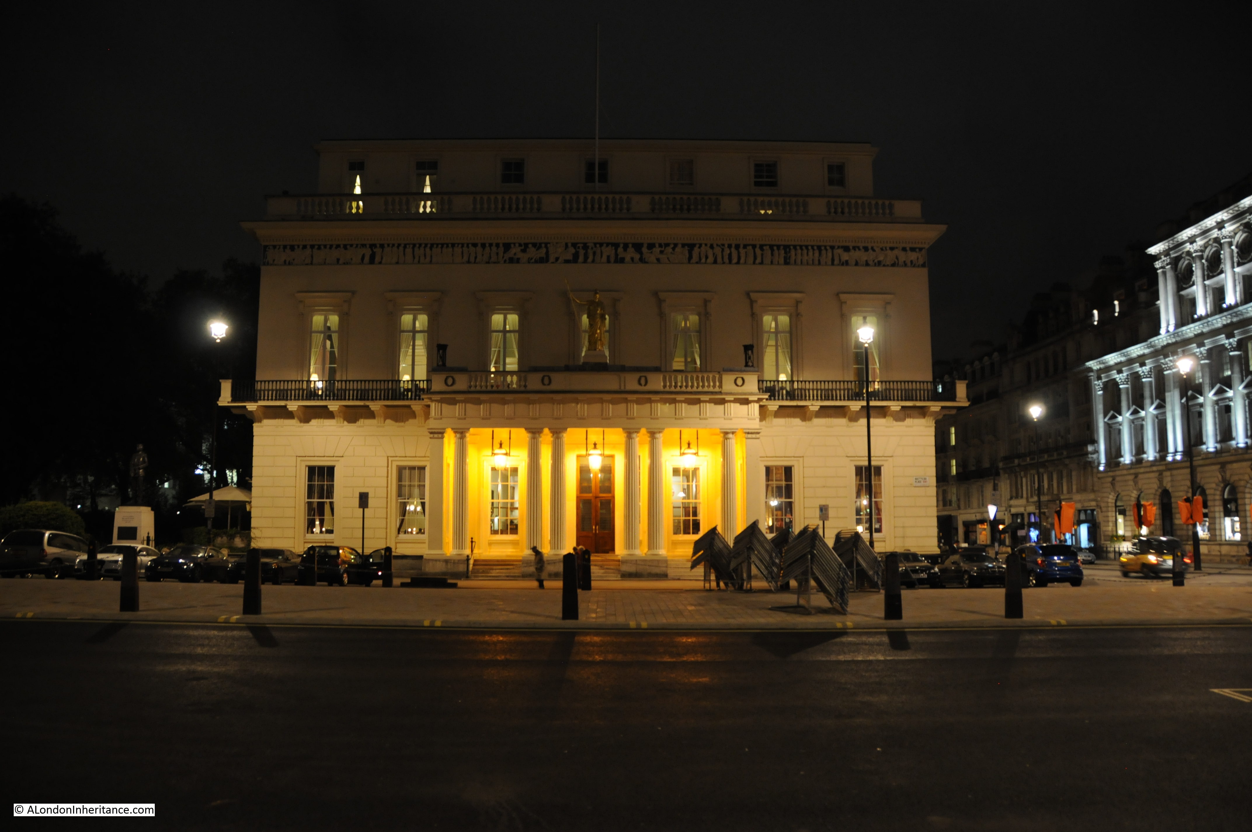
However as observers, we eventually left the Circus, walking south along Regent Street to Waterloo Place. Here we came across the Athenaeum Club in Pall Mall, which to me presented the most spectacular illumination of the night. The building, constructed in Ancient Greek style, had been freshly painted a pale yellow colour and subtly lit. The balustrade bordering the Club surmounted by torches. Each had been filled with oil or similar and lit, producing a spectacular dish of flame, adding to the warm light bathing the building.

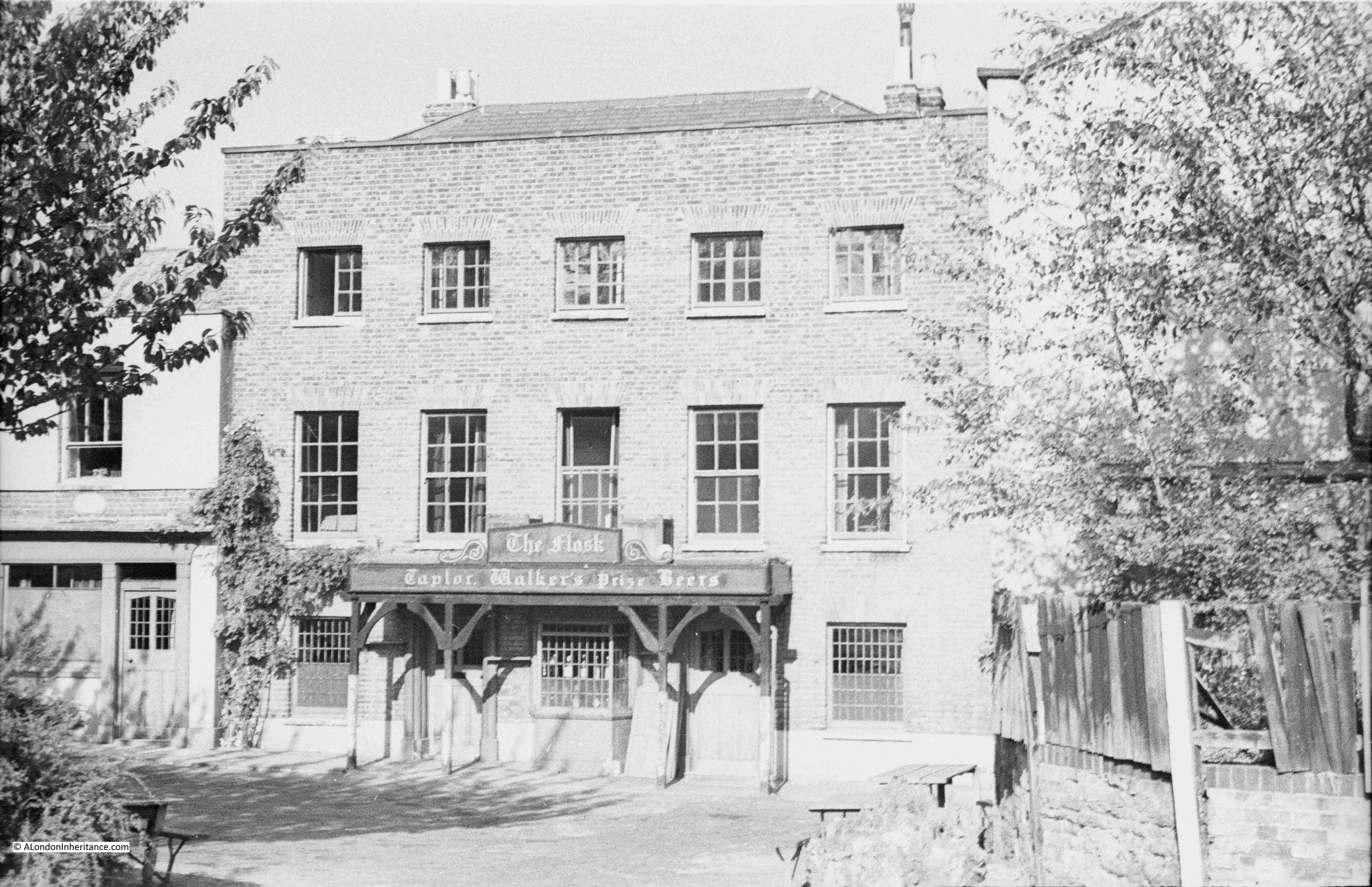
And so we made our way through central London taking it all in, the lights, the shop windows, the decorations and individual celebrations, until we found ourselves in Chiltern Street, which runs parallel with Baker Street. Celebrations at the London Fire Brigade building were well underway. The station gates were wide open and in the drill yard blazed a large fire. In one corner a piano was playing old favourites, while several elderly ladies performed a nifty “Knees Up Mother Brown”. We didn’t join in the dancing or sing any songs, but the beer and food was welcome, and I felt at home in the fire station.

Now the early hours of the morning, V.E. Day was over. we made our way home both wondering what life held in store for us.

Preliminaries to the 1945 General Election being contested by our great wartime leader, Winston Churchill, for me set the seal on the end of an era. I watched Churchill campaigning at Mornington Crescent, Camden Town, his open car surrounded by a rather hostile crowd. The great man was standing, raised hat in his left hand, cigar in his right. from an onlooker came a cry “Ere, Winston, try one of our fags!” followed by a Woodbine pack hurled at Churchill who turned the other cheek as his car drive on.

The future must have seemed very uncertain at the time. I suspect that he “felt at home in the fire station” was due to his grandfather, my great-grandfather being the Superintendent of East Ham Fire Station.

On Friday night, I set out from the West End to reach Chiltern Street by dusk and find out if the fire station was still there, and then walk back during the late evening to photograph the West End as it is now, very different to the same night 70 years earlier.

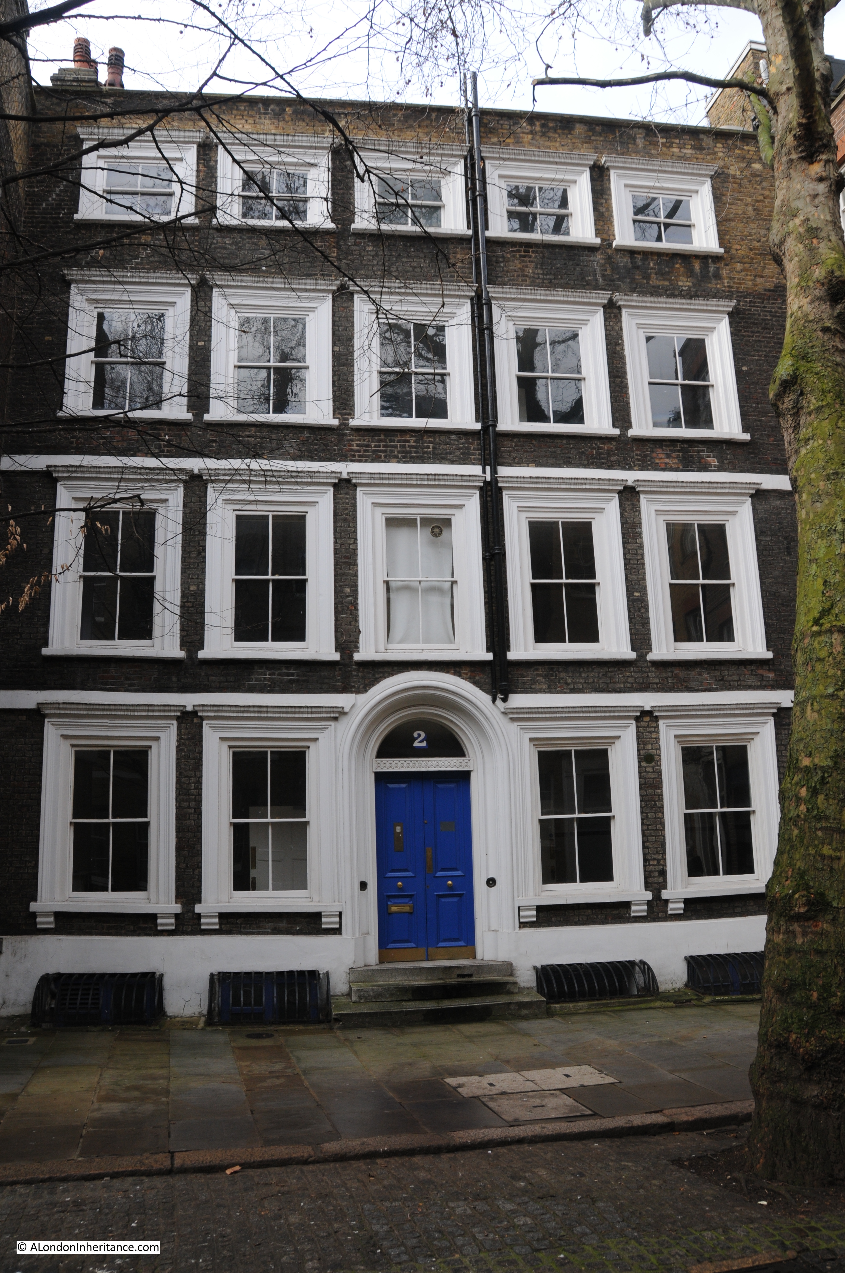
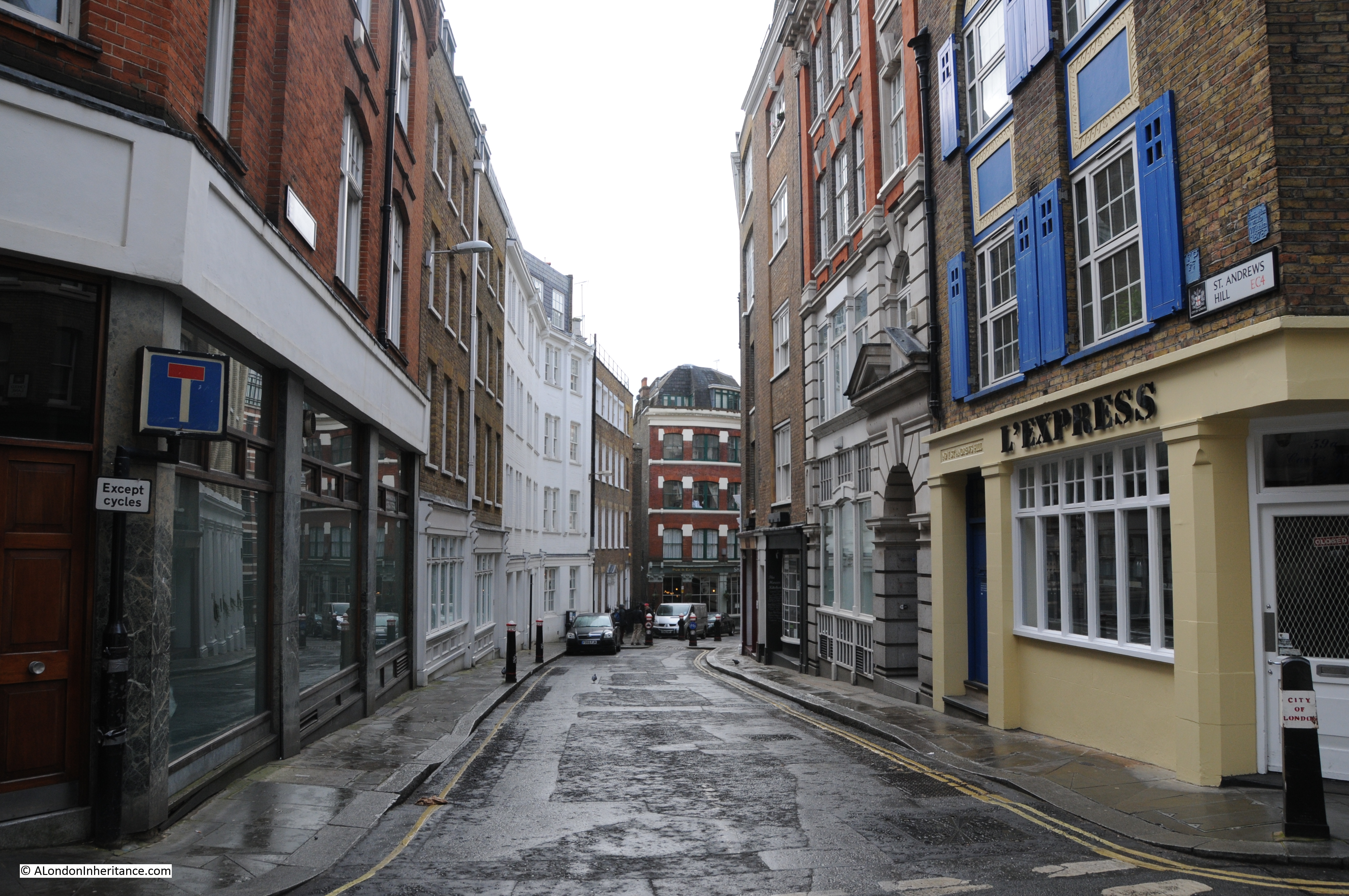
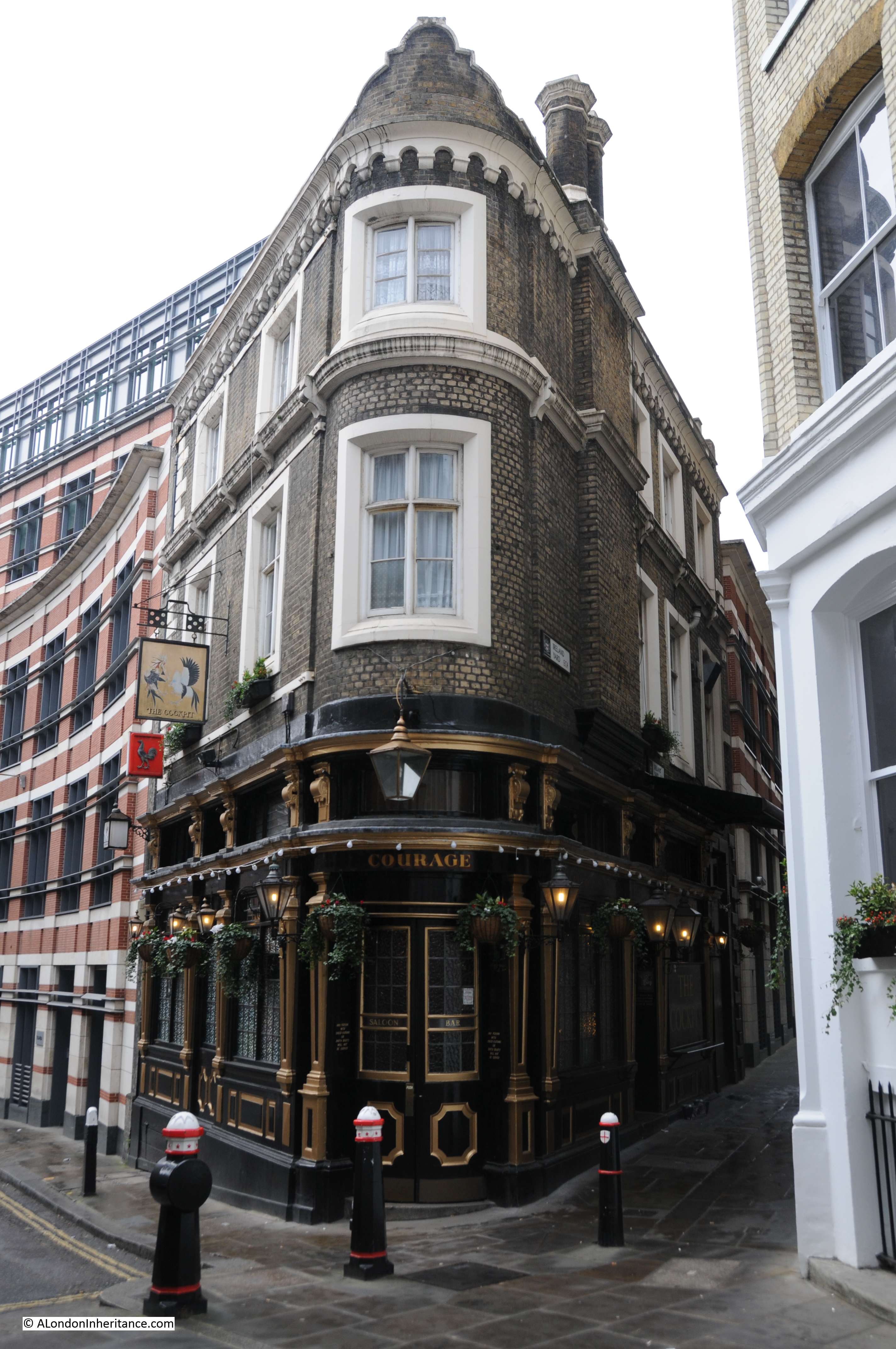
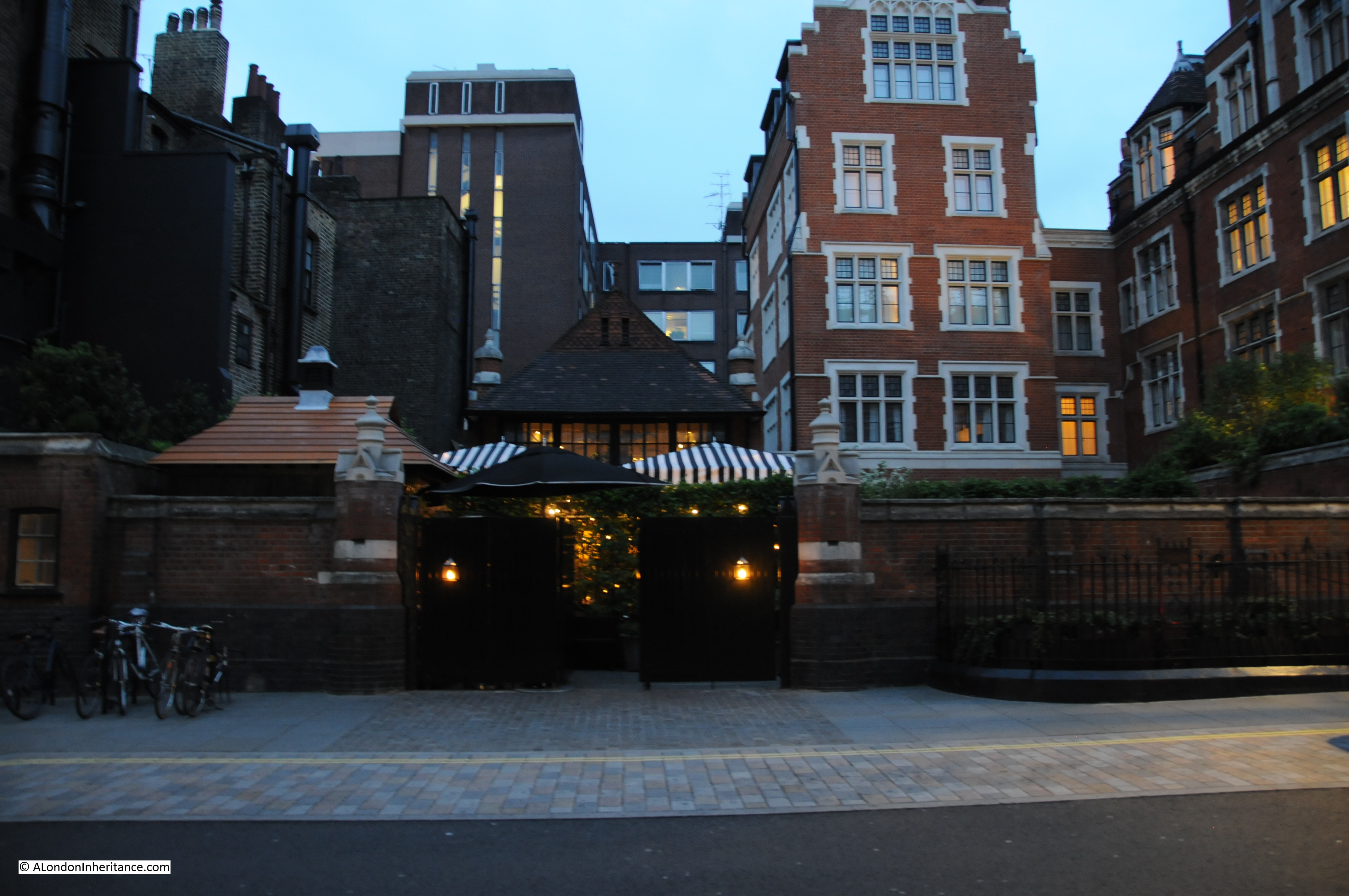
Turning off Baker Street and a short walk down to Chiltern Street, it was easy to spot the old Fire Station, the exterior looks much as it must have done when my father and Gus stopped here 70 years earlier, although now the building has a very different purpose. The building is now the Chiltern Firehouse, a bespoke luxury hotel and restaurant.

I took the following photo of the Fire Station as the light was fading on Friday evening. The original function of the building is very clear, the three large doors providing access to where the fire engines would have been waiting for a fast exit to the street.

VE Day 1

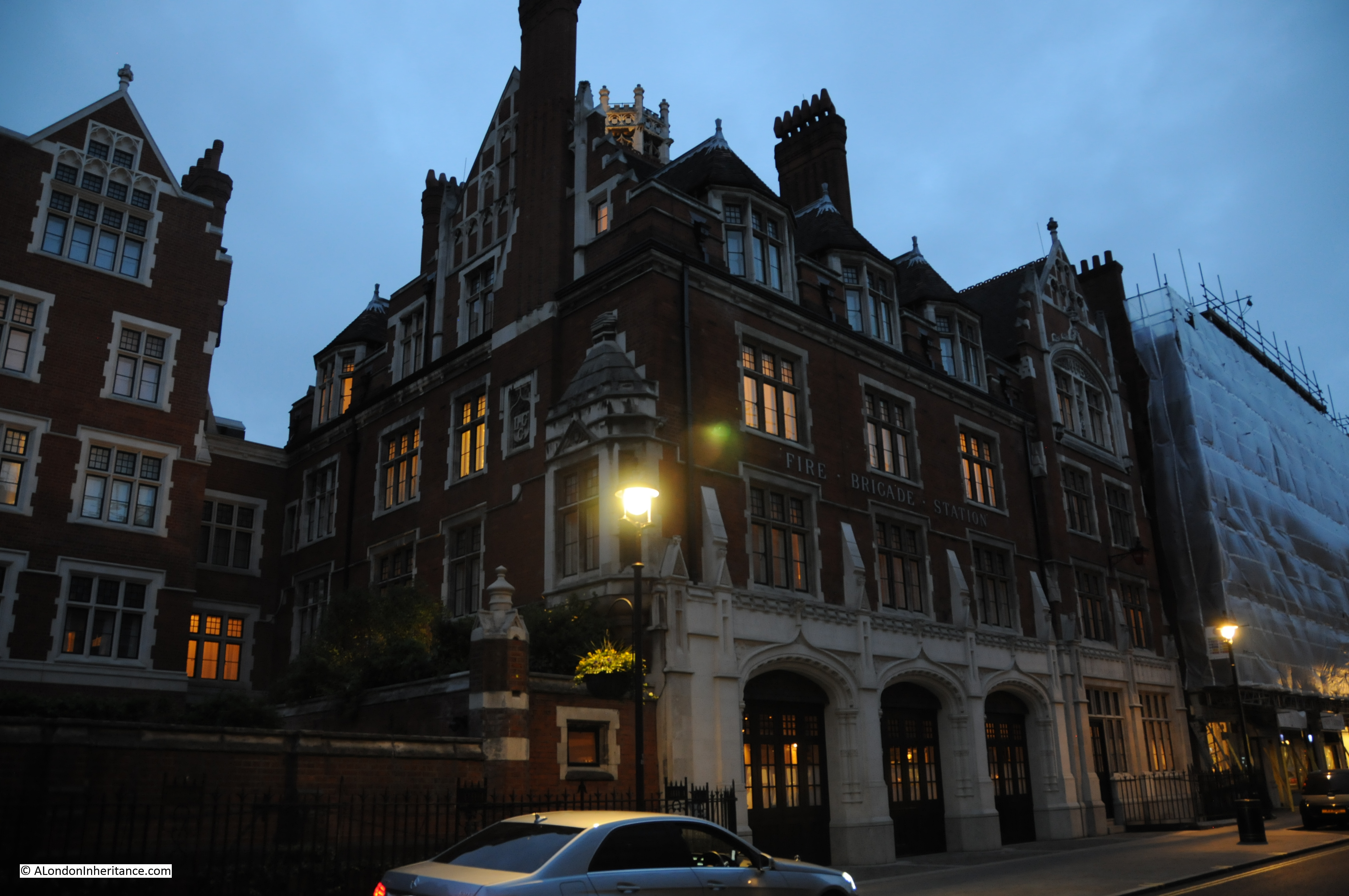
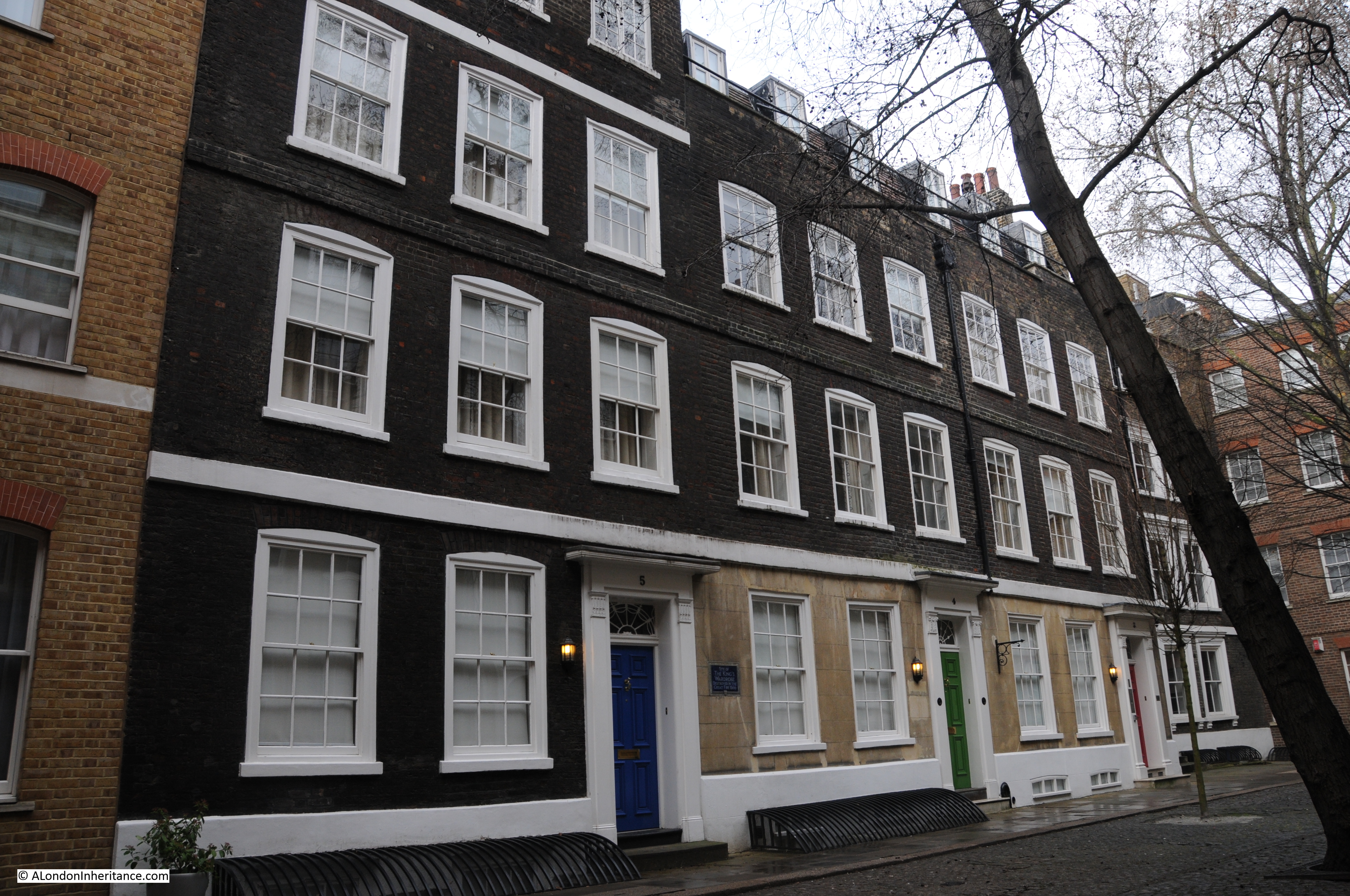
Just to the left of the main building is the old drill yard mentioned in my father’s account. This  also forms part of the Chiltern Firehouse and the original entrance still remains.

I stood for a while looking at what is a wonderful building, the architecture a clear statement of the standing in which the Fire Service at the time was held. As I waited, there was an almost constant stream of taxis dropping people off for either the restaurant or hotel and entering via the old drill yard entrance. Very different to the same place, 70 years earlier.

VE Day 2Pleased to have found that the Chiltern Street Fire Station building is still there, I then headed back through Manchester Square, to Oxford Street and then to the top of Regent Street.

In Regent Street looking back up to Oxford Circus:

VE Day 4
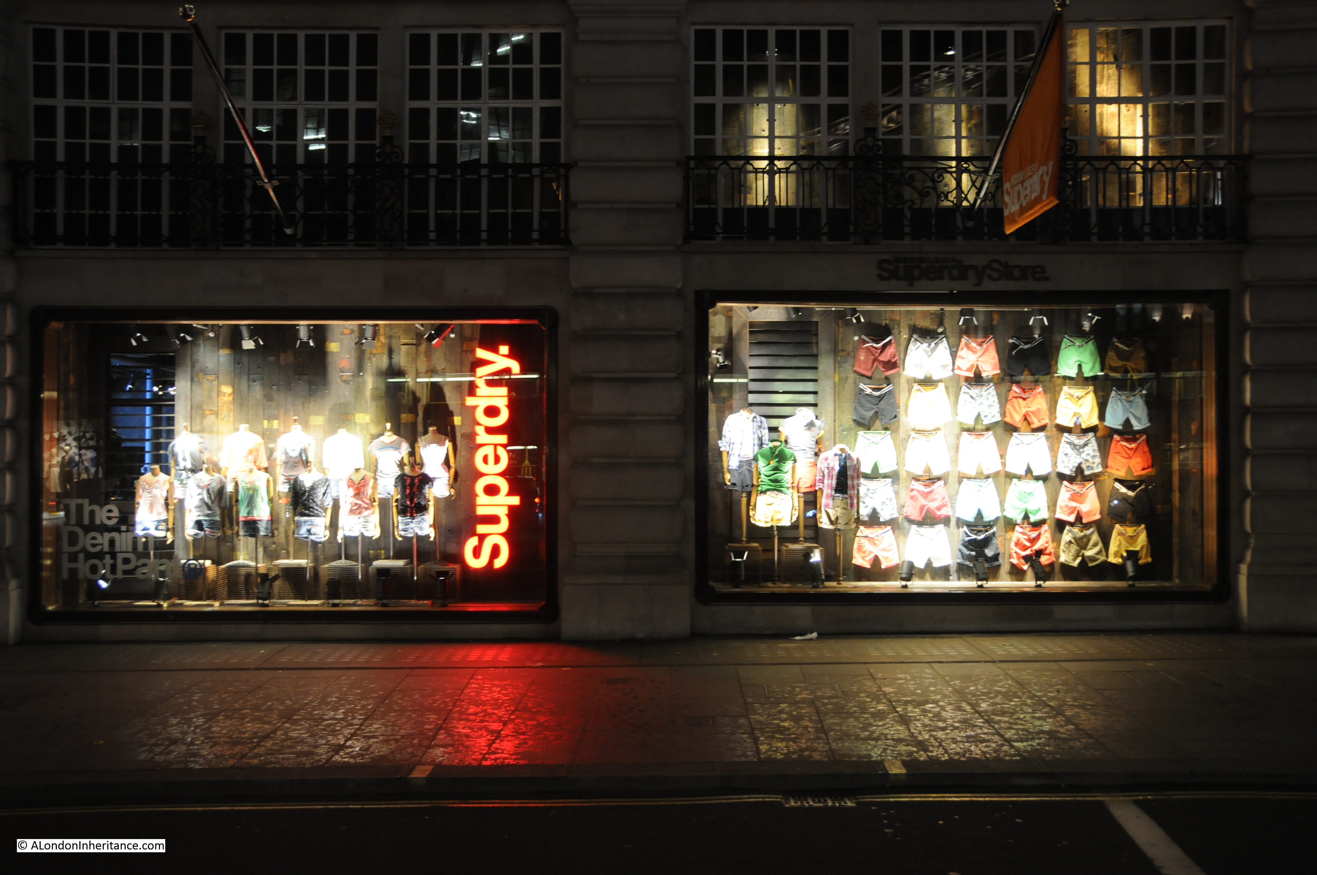
Regent Street is still lined with shops as it was in 1945, but the shops are now rather different than they were. Walk down the street now and you pass the status shops of global brands:

VE Day 3

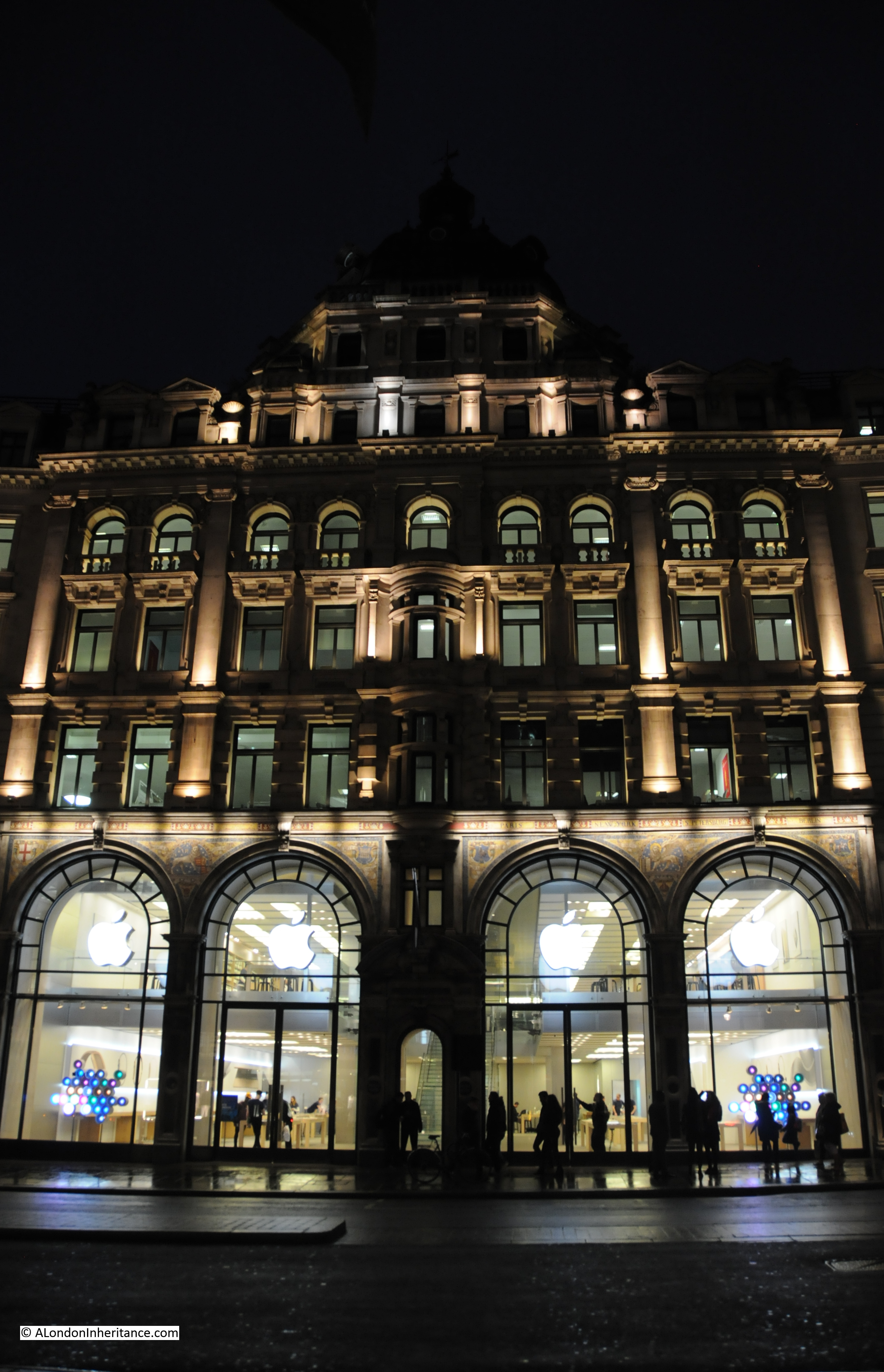
Shops with displays, variety and colour that would still have been a distant dream along the Regent Street of 1945:

VE Day 5

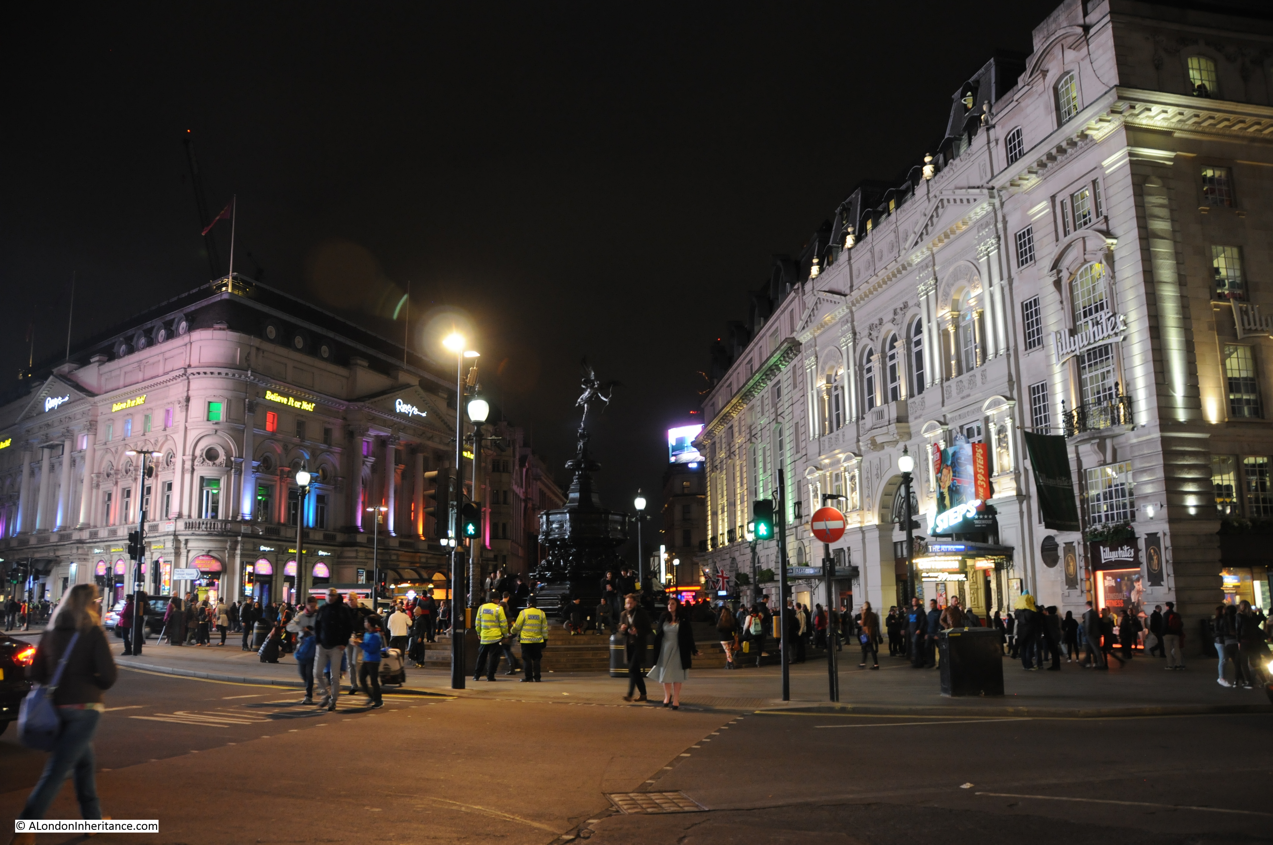
Regent Street is well-lit, but on reaching the end of this part of the street, the brighter lights of Piccadilly Circus beckon:

VE Day 6
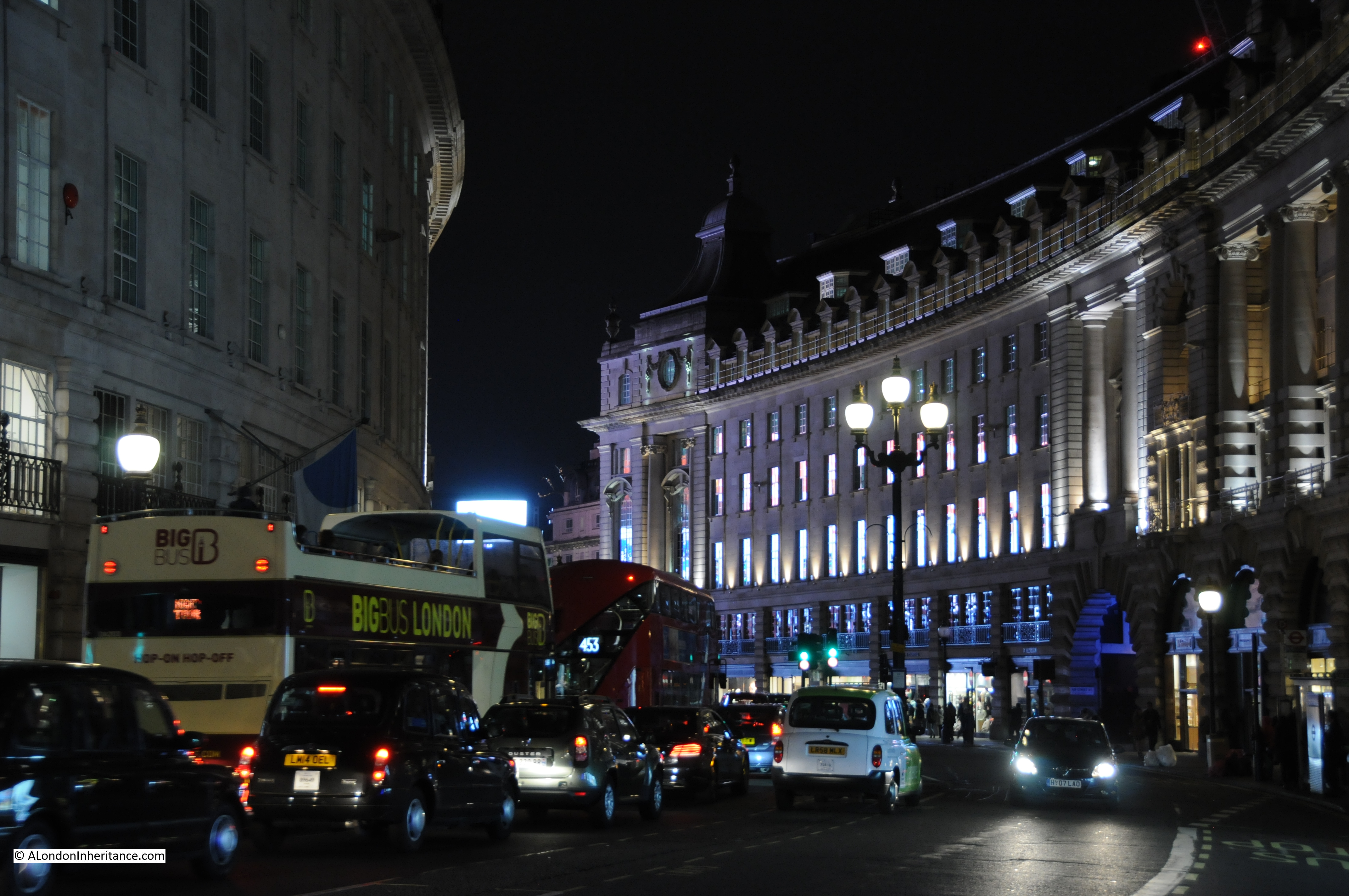
Piccadilly Circus is brilliantly lit at night and was one of the centres of celebration on the 8th May 1945. Late evening in 2015 and it is still busy, but nothing like the crowds my father was in, that were here in the same evening in 1945.

VE Day 7
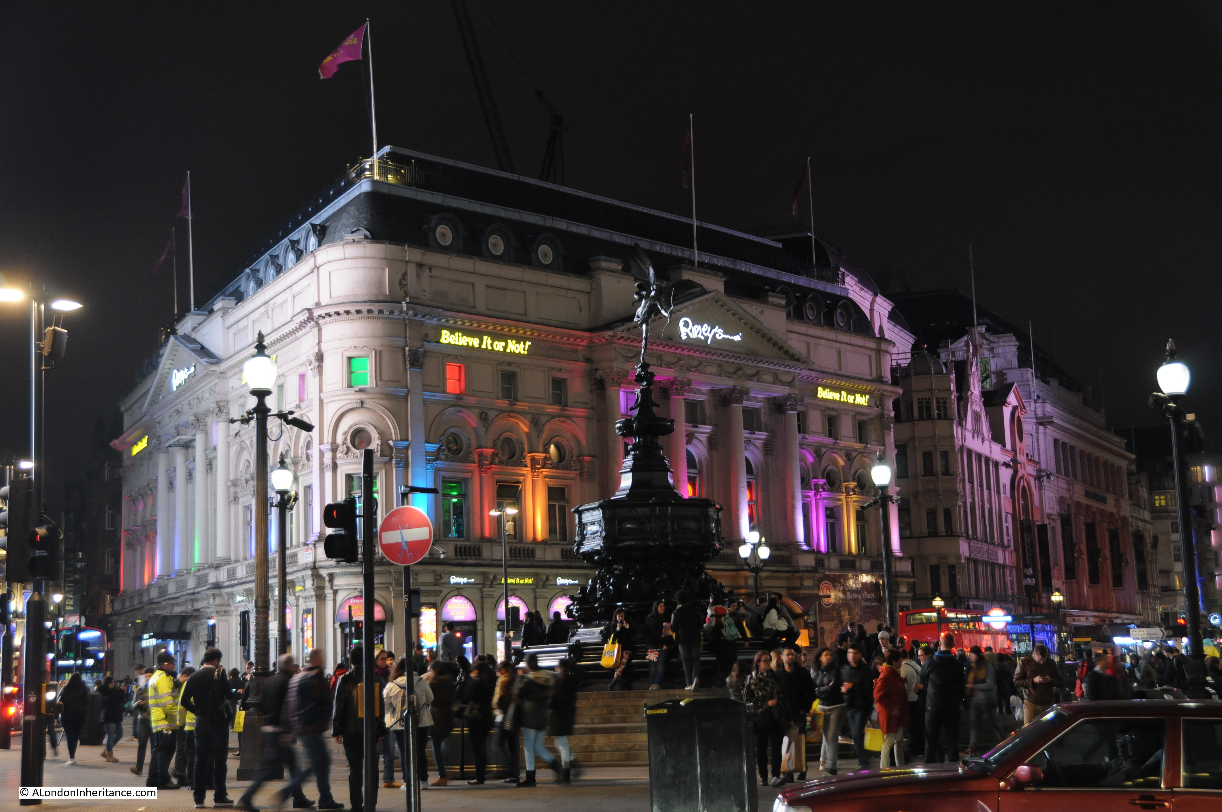
Eros as it is now generally known, or the Shaftesbury Memorial Fountain to use the original and full name is the focal point of Piccadilly, but sits almost in the shade of the surrounding buildings:

VE Day 8

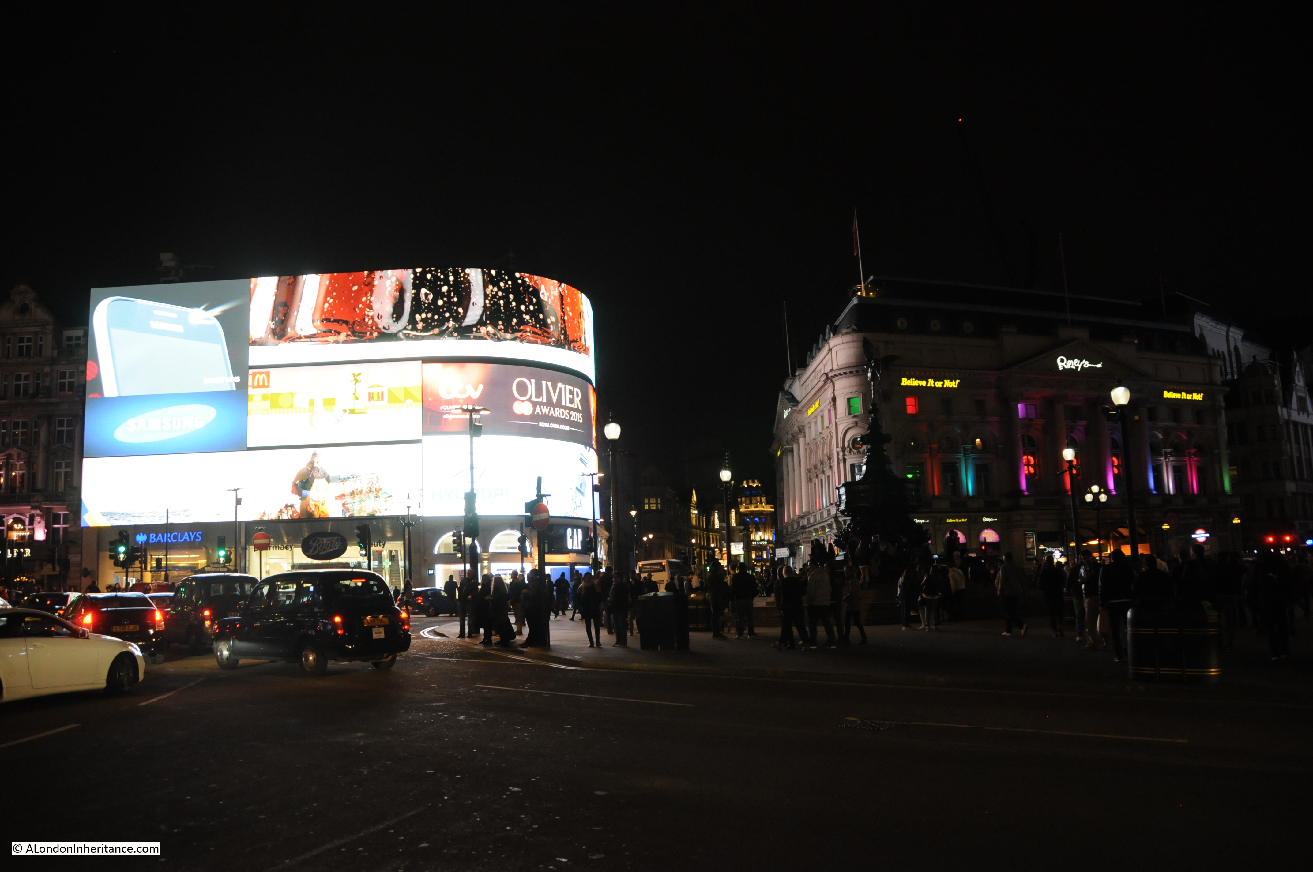
Illuminated advertising has always been a central feature of Piccadilly Circus:

VE Day 9I followed my father’s route through Piccadilly Circus and down to the lower end of Regent Street to Waterloo Place.

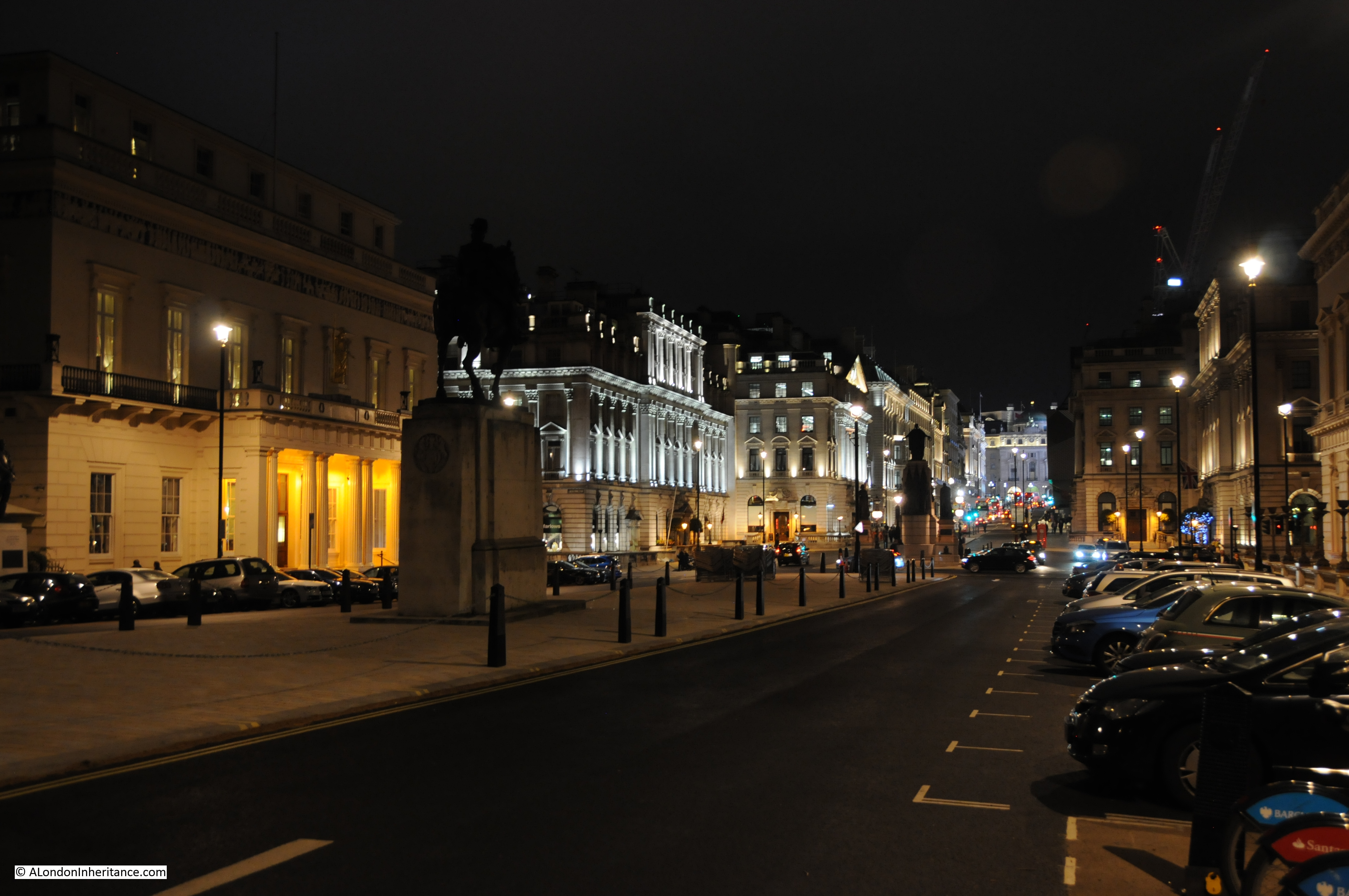
Waterloo Place is at the junction of Pall Mall and Regent Street and leads down to the 1834 column that forms the monument to the Duke of York. Much quieter than Piccadilly Circus and Regent Street.

Steps lead down from Waterloo Place to The Mall and I can imagine that in 1945 this was a far busier celebration route from Buckingham Palace to Piccadilly Circus.

Looking from Waterloo Place, up Regent Street to Piccadilly Circus:

VE Day 10

The Athenæum Club still faces onto Waterloo Place and as my father described in 1945 is still “painted a pale yellow colour and subtly lit” although on this 8th May the torches, which can still be seen around the 1st floor balustrade were unfortunately not lit:

VE Day 11The Athenæum Club on the left with the Crimean War memorial in the centre of Waterloo Place, looking up to the bright lights of Piccadilly Circus:

VE Day 12He did not say where else he walked on VE Day, but having been in Waterloo Place, there is a good chance that he probably walked down to The Mall and to Trafalgar Square, so I took the same route. Looking from the centre of The Mall towards Admiralty Arch:

VE Day 13
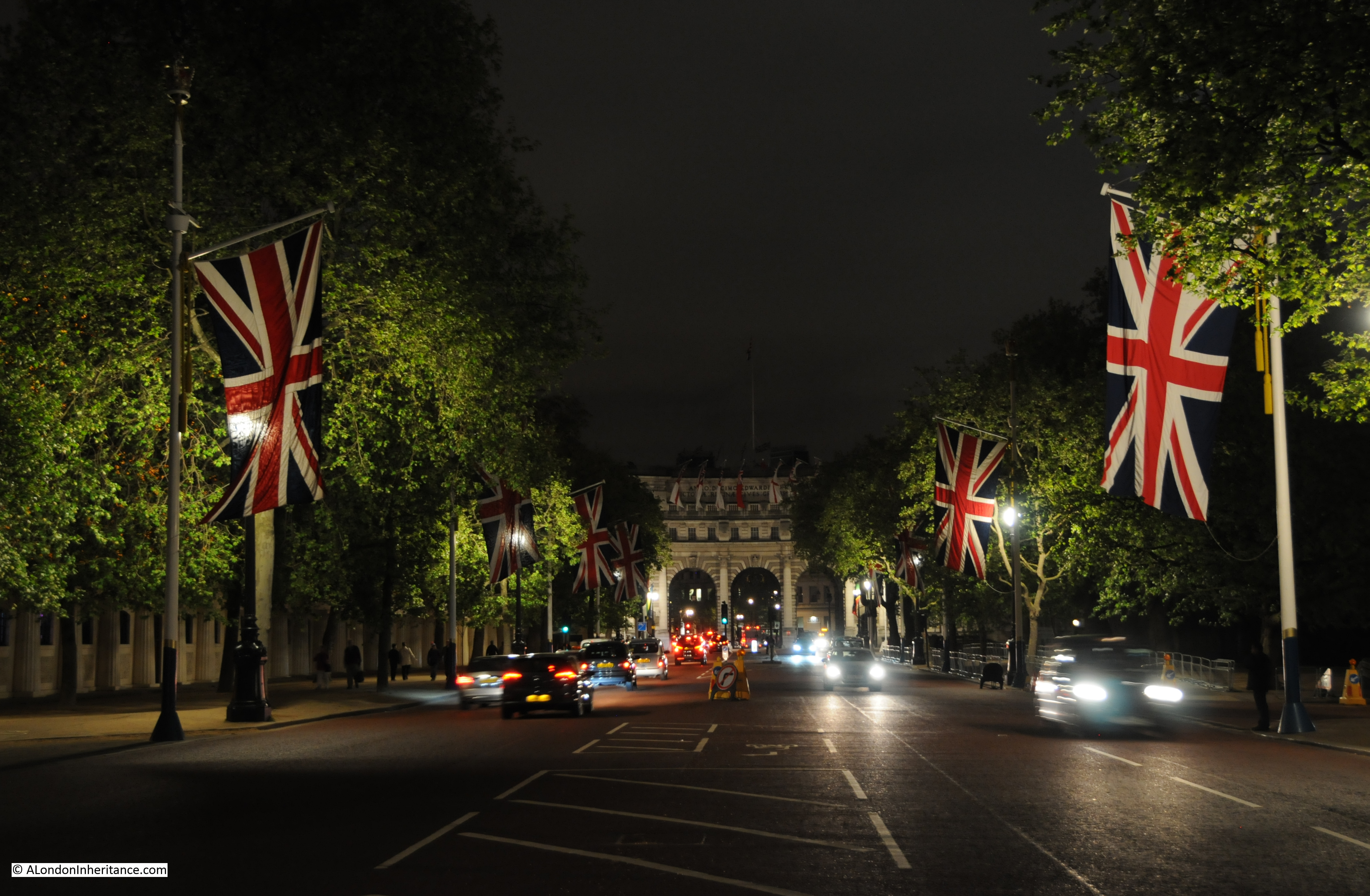
Flags on Admiralty Arch with the light from the searchlights in Trafalgar Square shining on the clouds. The searchlights had been set-up for the weekend as part of London’s celebrations of the 70th anniversary.

VE Day 14
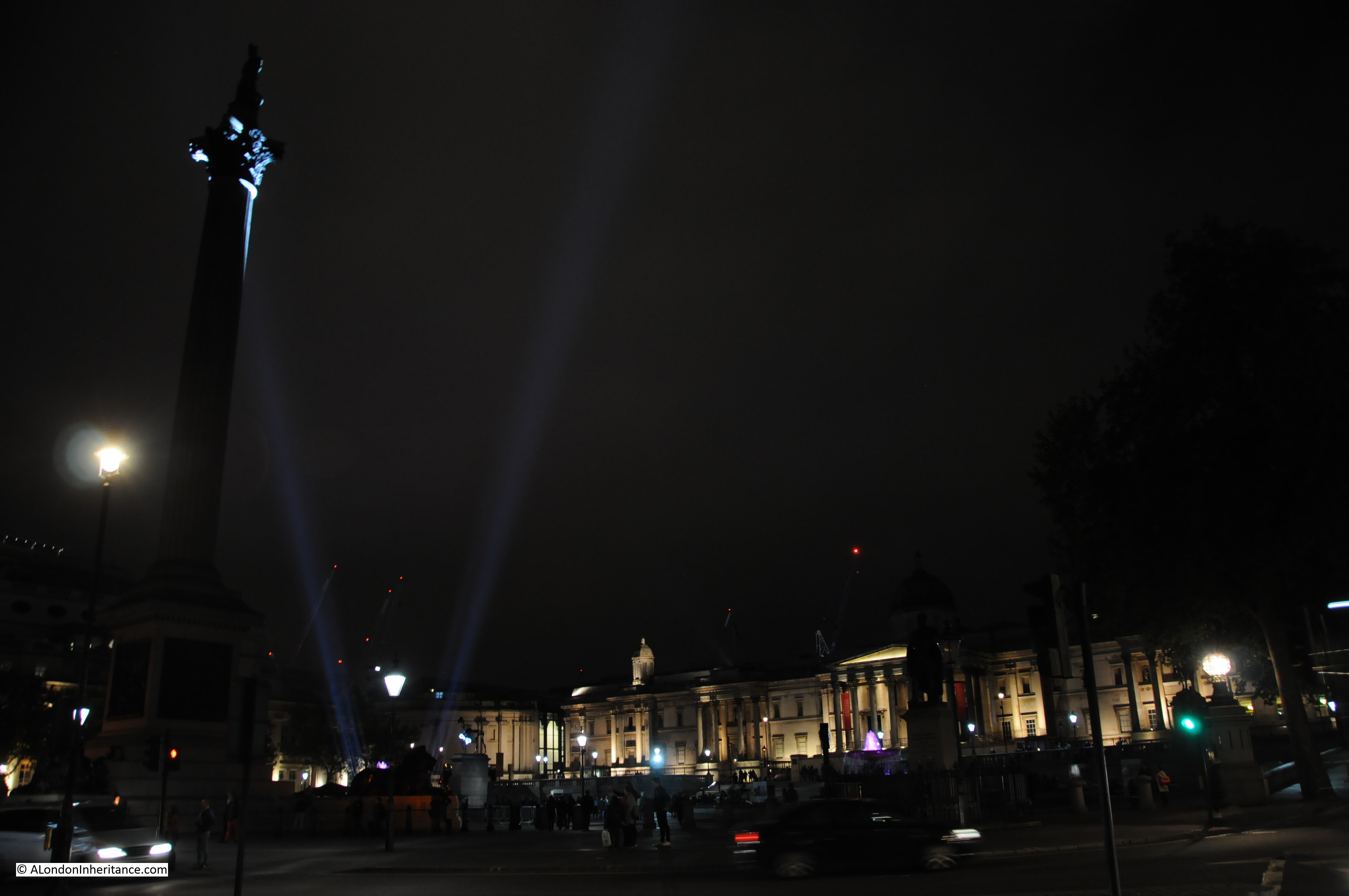
And in Trafalgar Square with the National Gallery in the background, the “V” searchlights pick out the top of Nelsons Column:

VE Day 15
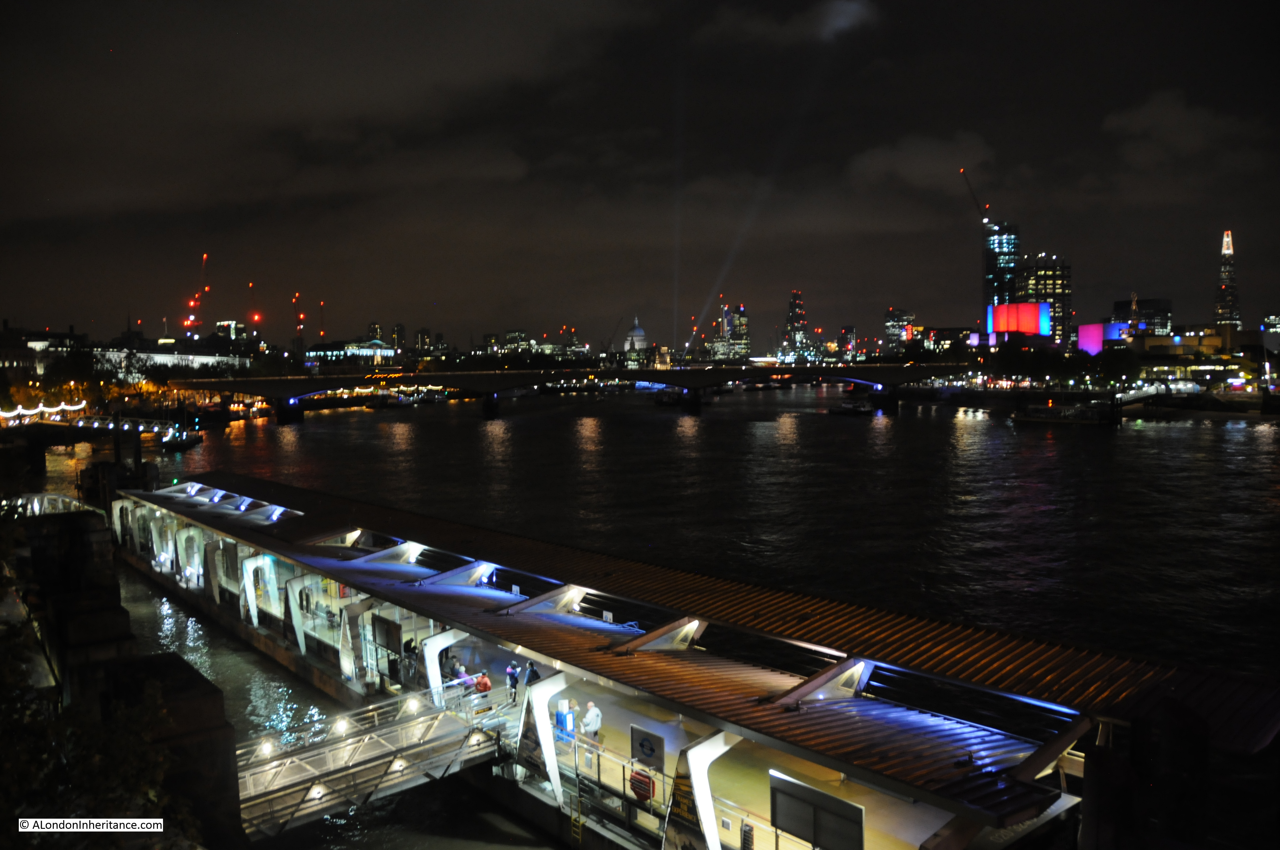
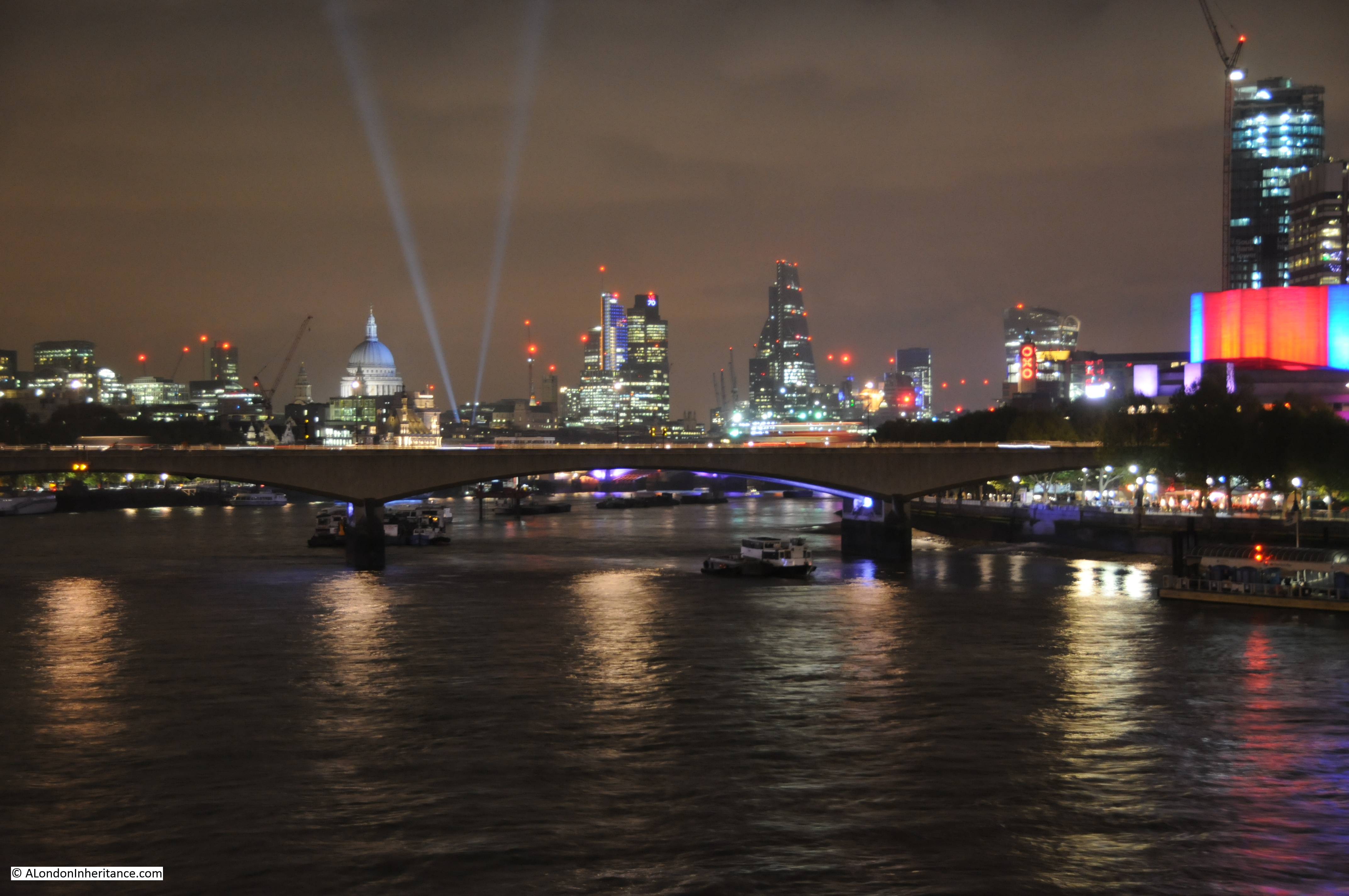
After Trafalgar Square I took a quick walk down to the footbridge alongside Hungerford Railway Bridge to see if the “V” searchlights from St. Paul’s Cathedral were visible. The view along the Thames to the City from here is fantastic during the day, but takes on an additional dimension at night. 70 years ago, this view would probably still have been dark, although searchlights that had been used a few years earlier to pick out enemy bombers were being used that night to illuminate the Cathedral.

VE Day 16And a final close-up clearly shows the V searchlights from St. Paul’s Cathedral:

VE Day 17It was fascinating to walk the same route as my father and his friend Gus, exactly 70 years later and consider how London has changed. I was really pleased to find that the Chiltern Street Fire Station is still there.

My father’s account of his life in London during the war was written soon after. The lack of much detail about VE Day itself, rather thoughts and concerns about the future probably reflect how many Londoners of the same age were feeling. After six years of war, the years of bombing, the V1 and V2, the threat to London had at last been removed, however the war in the far east was far from an end and National Service was imminent.

He did not take any photos on the night, as he did not get his first camera until 1946. When he did, one of the first photos was of St. Paul’s Cathedral lit up by searchlights. So, to finish off, this must have been how the Cathedral appeared on VE Day:

VE Day 18

alondoninheritance.com


The Royal Festival Hall – Dramatic Effects Of Space And Vista

I recently scanned some of my father’s photos which included the last photos he took in the early 1950s of the Royal Festival Hall. These photos show the area soon after the closure of the Festival of Britain when much of the infrastructure for the Festival was still in place.

At the end of this post I have put together a time sequence of photos of the site from 1947 through to 2015 showing the original site, during construction and photos taken in the early 1980s and 2015.

But first, the recently scanned photos, the first is of the Royal Festival Hall taken soon after closure of the Festival of Britain exhibition, from the footbridge alongside the Hungerford Railway Bridge.

Festival H4

And from the same location in April 2015:

Festival H6

The overall shape of the Royal Festival Hall is exactly as it was when first built, however there have been a number of cosmetic changes to the front with the middle tier window line now stretching across the full front of the hall and changes to the top tier with a balcony now between the glass and the front of the hall.

I planned to take the 2015 photo before the trees had come into leaf as when the leaves are fully grown the trees considerably obstruct the view of the hall. I was not early enough!

Please do not get me wrong, we do not plant enough trees, within the city and across the country, however there are some places where trees are in the wrong position. The Royal Festival Hall is, in my view, one of the very few buildings constructed soon after the last war that works well architecturally and is in the right location. The Royal Festival Hall was always designed to be seen from and across the River Thames and to provide views along to the City.

The trees in front of the building considerably obscure the building from the walkway across Hungerford Bridge and from the north bank of the Thames.

As the original Festival Guide stated:

“The Royal Festival Hall can claim to be a work of art in itself. The superb dramatic effects of space and vista, within the building and beyond it to the river and the city, are things which the visitor will discover for himself.”

Note also how in the original photo the Royal Festival Hall did not have any buildings in the background to detract from the view of the hall. A very different situation in 2015. To the right of the hall is the building that was the downstream building of Shell Centre, but has now been converted from offices to apartments. To the left is the Kent House Tower above the London TV Studios and behind that with the crane on the top is the South Bank Tower, again another building being converted from offices to apartments.

Walking a short distance further along the Hungerford footbridge, we can take a look down at the walkway in front of the Royal Festival Hall:

Festival H3

The poles are part of the decoration from the Festival of Britain. The photo also shows the observation platforms which I have heard of, but not seen photos of until scanning these negatives. There were six of these raised platforms extending just over the river wall and must have been a fantastic place to sit and view the surroundings.

At the far right of the photo is the Shot Tower, to the left can just be seen the walkway to the river pier, and in the distance is an excellent view over towards St. Paul’s Cathedral.

The view is very different in 2015:

Festival H7

The observation platforms are unfortunately long gone, and later replicas of the poles that can be seen in the original photo are just visible, however the view is considerably obstructed by the trees. Again, an example of why I would argue that this area of the Southbank is the wrong place for trees and their removal would open up both the view of the Royal Festival Hall and the views along the river and to the city.

The guide-book for the Festival of Britain shows the area in front of the Royal Festival Hall including the six observation platforms:

Festival H9

Walking almost to the end of the footbridge, we can look down and watch those out for a walk along the Southbank:

Festival H2

And the same location in 2015:

Festival H8

And a final view across to the Royal Festival Hall, with the Shot Tower on the left:

Festival H1

During the Festival, the Shot Tower had a Radio Telescope aerial mounted on the top. I had always assumed this was for decoration only, however the Festival Guide explains that it was a fully working system that would bounce radio signals off the moon, allowing visitors to see the time delay between the transmitted and reflected signal. The aerial system was mounted on a redundant gun mounting which could be moved to allow the aerial to track the moon.

From the Festival Guide Book:

“The Tower has been one of the landmarks of London since it was built-in 1826. It remains the only old building on the site, to serve as a beacon for the Festival. It is a beacon in two senses: it is a modern lighthouse with a double flashing beam welcoming visitors as far as 45 miles away when the weather is clear; it is a radio beacon directing radio signals to the moon and beyond into space.

The lighthouse mounted at the top will flash from sunset to Exhibition closing time. It has a power of 3 million candles. It is of the most modern all-electric design and so takes up far less space than the older types which needed weighty lenses to intensify the beam. The light itself comes from a lamp of three thousand watts; an automatic device ensures that a second lamp can swing into position should it fail. This lighthouse optic is the work of Chance Brothers Ltd., who made all the glass for the original Crystal Palace a hundred years ago.

The radio beam is above the lighthouse optic. The most obvious part of it is a large reflector which beams the signal from the aerial within it on to the moon. This is part of the radio telescope and is connected with the display in the Dome of Discovery by underground cable. In the Dome visitors can transmit signals to the moon and actually see them reflected back to the earth after about two and a half seconds.”

This was 64 years ago and I wonder if our public demonstration of science has progressed much since.

The following is from the Festival Guide and shows the detail of the top of the Shot Tower. As with the observation platforms, it would have been good if the Shot Tower could have been preserved as part of the Southbank’s history.

Festival H10

Also on the negatives were some photos of the following structure:

Festival H5

This was at the far eastern end of the Festival Hall site (Waterloo Bridge can just be seen at the lower right). The numbers on the central arch are the years 1851 and 1951.

1851 was the year of the Great Exhibition held in the “Crystal Palace” in Hyde Park. This structure looks to be a very rough approximation of the original Crystal Palace building. Both exhibitions had a very similar theme to demonstrate the country’s strength in industry and science.

I have featured this area of the Southbank in a number of posts to highlight different periods in the development of the site. I have brought the photos taken by my father and myself together in the following sequence to show how the site has changed from 1947 to 2015.

Starting in 1947, and the site still retains the original buildings with the Shot Tower on the left and Lion Brewery building to the right:

Festival 4

Construction starts. This is a panorama of several of my father’s photos to show the whole of the building site that would become the Royal Festival Hall:

Panorama

Construction is now well underway with cranes and scaffolding surrounding the building (compare this with the 1947 photo):

Festival 1

And repeating the photo from this week’s post, the completed Royal Festival Hall just after the Exhibition:

Festival H4

Now fast forward 30 years to the early 1980s and this is one of my photos of the Royal Festival Hall. Still no trees and the hall is an impressive site from the north bank of the Thames:

Festival H11

Summer 2014 and even from the height of the walkway along the side of Hungerford Bridge, the hall is hiding behind the trees:

trees

The guidebook to the Festival in the section on the Royal Festival Hall explains that it is a work of art in itself  and “the superb dramatic effects of space and vista, within the building and beyond it to the river and the city“. With the way that London is growing, the opportunity to appreciate space and vista at ground level is diminishing. It would be good if the area in front of the Royal Festival Hall could be opened up again to meet the original intentions of the architects.

You may also be interested in my other articles on this area:

The South Bank – Before the Festival of Britain and the Royal Festival Hall

The Royal Festival Hall – Before, During And After Construction

alondoninheritance.com

An Optimistic View Of The Future – Adverts From The 1951 Festival Of Britain

My father took a range of photos of the south bank area of London just after the last war, prior to the construction of the Festival of Britain Exhibition.

Some I have already published here and here.

I have been researching and reading about the Festival of Britain and one very good source is the Guide to the South Bank Exhibition that was published to guide the visitor around the site and to provide a “Guide To The Story It Tells”.

The content about the Festival is fascinating, but I also find the adverts within the guide of equal interest. They provide a snapshot of how advertising reflected the country of the time.

The adverts are highly artistic and the colours used are very vivid, probably reflecting the optimism about the future that was one of the main themes of the Festival after so many years of austerity.

The adverts also tell a story of how British industry has changed over the past 64 years.

So, for a change of theme this week, let me show you some of the advertising from the Guide to the South Bank Exhibition.

Advert 12

The first is from Costain. A construction company founded in 1865 by Richard Costain who moved from the Isle of Man to Liverpool and began trading as a builder. Costain are still an independent company to this day and are actively involved in many major infrastructure projects around London including the London Bridge station redevelopment.

The advert shows the transformation of the Festival site and the Dome of Discovery from initial plans in 1949 through to completion in May 1951.

Advert 20

Horseley Bridge and Thomas Piggot were a major firm of construction engineers specialising in iron and steelwork and were responsible for the steel work on the Dome of Discovery. Much of their work remains in use to this day, including Richmond Railway Bridge.

Advert 11

The Shell and BP advert shows the view  of part of the Festival site, the current location of the Royal Festival Hall, prior to demolition. The view is from Shell-Mex House which is directly opposite the site on the north bank of the Thames and although not now occupied by Shell, the building is unchanged to this day.

The view of the Festival site shows the Shot Tower on the left and the Lion Brewery building to the right.

Shell would continue to have a link with the Festival of Britain site as following closure, Shell Centre, the head office for the international part of Shell’s business was built on the site.

Advert 16

Allied Ironfounders Ltd was formed in 1929 from the consolidation of ten smaller companies and was responsible for a wide range of products including the Aga Cooker through the takeover of Aga Heat in 1935.

Allied Ironfounders lasted as an independent company until 1969 when it was taken over by Glynwed. Within 30 years the company had sold off virtually all of the metal working parts of the business and in 2001 was renamed Aga Foodservice Ltd to concentrate on the remaining part of the business.

Note the text underneath the illustration regarding the gates from the Great Exhibition of 1851 and their transfer to the boundary between Hyde Park and Kensington Gardens – I did not know that.

Advert 23

Ovaltine was invented by a Swiss chemist in 1904 and was first available in the UK in 1909. Still widely available over one hundred years later and based on the same core ingredient of barley malt. If I have understood chains of ownership correctly, Ovaltine is now owned by Twining’s which in turn is owned by Associated British Foods.

Very idealised view of the Ovaltine Egg Farm, the Ovatine Dairy and the Ovaltine Factory in a Country Garden.

Advert 8

Horlicks is another malted drink which is still in production today, now owned by GlaxoSmithKline (who have their head office in Brentford, West London).

Another idealised view, but this time of a house in the country (very different to the homes of the majority of Londoners at the time)

Advert 13

Barkers of Kensington was a Kensington department store which opened in 1870. Sold to House of Fraser in 1957, it was finally closed in 2006. The Barkers building still remains and is a major landmark on Kensington High Street.

Advert 4

Arthur Lassenby Liberty started trading in Regent Street in 1875. The current store shown in the above advert was built-in 1924. Liberty’s are still trading in the same building to this day with much the same ethos.

Advert 5

The Gas Council’s advert with Mr Therm standing in front of a backdrop of the festival site with the Dome of Discovery and the Skylon. Gas provision at the time was a nationalised industry, privatised in the 1980s as BG Group and Centrica.

Note the comment about gas and coke helping to get rid of fog – still a major issue in 1950s London.

Advert 9

This is an advert you will not see today – cigarettes, in this example Craven ‘A’ trying to project a very sophisticated image for the brand. Still available as a brand today, but as far as I can tell, mainly in Canada.

Advert 15

And perhaps in 1951, to complement your Craven ‘A’ you would also have had a Curtis London Dry Gin, distilled in London since 1769.

Advert 10

Also advertising in the Guide were many of  the country’s industrial companies of the early 1950s.

English Electric were a major industrial concern, manufacturing a very wide range of electrical, engineering and aeronautical products and during the early 1960s were a British manufacturer of mainframe computers.

The aeronautical part of the business became a founding member of the British Aircraft Corporation which in turn became BAE Systems.

The rest of the business was merged with GEC in 1968 which spectacularly failed in the first years of the 21st century after the disastrous decision to try to turn the company into an Internet infrastructure business to the detriment of the core engineering parts of the business.

I wonder what those attending the Festival would have thought if they had known that companies that at the time seemed so innovative and core to the country’s industrial identity would have disappeared within 50 years.

Advert 14

Another manufacturer that would disappear was E.K. Cole or Ekco who started manufacturing radio sets from 1924 and later television sets in Leigh-on-Sea and Southend.

Ekco products must have been in many homes across the country at the time of the Festival and must have appeared to be a very strong company and brand.

Ekco merged with Pye, another British electronics manufacturer in 1960 and the combined company was taken over by Philips in 1967 with the Ekco brand disappearing.

Advert 19

Cossor was another British electronics company that would disappear in a couple of decades. The company started trading in 1859 as a manufacturer of scientific glassware and this expertise helped the company move into the production of electronic valves and cathode ray tubes. This led into leading technologies such as radar both during the 2nd World War where Cossor was one the companies that helped develop the Chain Home radar system along the coast and following the war into radar for air traffic control.

Cossor was purchased by the US manufacturer Raytheon in 1961, just ten years after the Festival of Britain and is another example of the loss of British industrial capability over the last 60 years.

Advert 3

Sperry was a manufacturer of navigation equipment and gyrocompasses. Now owned by the American business Northrop Grumman Corporation.

Advert 7

Siemens Brothers and Company Limited was the 1951 incarnation of the original Siemens company formed in 1843 by Wilhelm Siemens of Germany. The shares of the British business were confiscated at the start of the 1st World War and finally became part of Associated Electrical Industries in 1955 which then merged with GEC in 1967 which as stated above with English Electric failed in the early 2000s.

The original German part of Siemens is now a major global manufacturer and well established in the UK, manufacturing in Germany many of the trains that now service London

Advert 21

One brand that is still very much in business today is Cow and Gate. originally a grocery shop in Guildford owned by the Gates family in 1771, the business expanded into dairy products which led to powered milk and then to milk food for babies.

Smiler, the Cow and Gate “royal baby” was introduced to the branding in 1930.

Although still in business, Cow and Gate is now owned by the French multinational Groupe Danone.

The Festival of Britain and the South Bank Exhibition that formed the core of the Festival was intended to show a strong, confident country, full of innovative industrial and manufacturing companies that could be expected to bring a prosperous future after the long years of war and the austerity that followed. The following decades would bring significant change to, and the demise of many of these companies.

I have shown just under half of the adverts featured in the 1951 Guide to the Festival, the rest have the same standards of artwork and it is interesting that there is only one financial business (Lloyds Bank) featured. Again perhaps how the country (or at least the organisers of the festival) wanted to portray what was important to the country and to the future from the perspective of 1951.

alondoninheritance.com

Highgate – Pubs, History And Architecture

Highgate has been high on my list to visit as some of my father’s photos from 1948 are of the pubs and buildings around the centre of Highgate and with the recent good weather, a destination with a pub seemed perfect.

Highgate is probably better known for the cemetery of the same name, however the village at the top of the hill is well worth a visit to view some of the architecture and stop at some of the many pubs.

Coming out of London, up Highgate West Hill, after a long climb up to the heights of Highgate we reach the Flask. This is how the Flask looked in 1948:

Highgate 2

And my April 2015 photo shows the pub looking very much the same:

Highgate 1

It is really good that in the intervening 67 years there has not been too much change to the pub. The main difference being the courtyard area in front which is now a seating area, although in the 1948 photo you can just see some tables and chairs to the right and left of the courtyard so perhaps even this has not changed that significantly.

Internally, the pub has avoided the conversion to a large open space, the fate of so many other pubs. The Flask still has many small bar areas and rooms at different levels and is probably much the same as when my father visited in 1948.

The name of the pub is apparently from the flasks that were sold from the pub to collect water from the local springs.

Hogarth allegedly drank at the Flask. From Old and New London:

“During his apprenticeship he made an excursion to this favourite spot with three of his companions. The weather being sultry, they went into a public-house on the Green, where they had not been long, before a quarrel arose between two persons in the same room, when, one of the disputants having struck his opponent with a quart pot he had in his hand, and cut him  very much, causing him to make a most hideous grin, the humourist could not refrain from taking out his pencil and sketching one of the most ludicrous scenes imaginable, and what rendered it the more valuable was that it exhibited the exact likeness of all present.”

Fortunately the Flask was very peaceful during my visit, and it was the perfect location to enjoy the spring sunshine.

Another view of the Flask from the side, passing along Highgate West Hill in 1948:

Highgate 4

And today in April 2015:

Highgate 3

The Flask is now a Fuller’s pub. In 1948 as can be seen from the sign above the entrance it sold Taylor Walker’s Prize Beers.  Taylor Walker was founded in Stepney, East London in 1739 and originally brewed beer in Limehouse. It has been through a number of changes in ownership and is now a brand owned by Spirit Pub Company. At some point since 1948, it was acquired by Fullers who still brew beer in Chiswick, West London.

Part of the Green referred to in the Hogarth reference is still in front of the Flask and gives the impression of being in a country village rather than north London:

Highgate 14

The direction sign gives the very stark choice of either entering Highgate Village or going to the North. Highgate obviously has a very low opinion of the value of visiting anywhere else in the local area.

Highgate 15

Leaving the Flask and completing the walk up the hill, we find another pub, the Gatehouse. Highgate does seem well provided with pubs. In 1826, Old and New London records that there were nineteen licensed taverns. The pubs of Highgate practiced a custom whereby strangers visiting a pub had to swear an oath on a set of animal horns (each pub having their own). Byron referred to the ceremony in Childe Harold’s Pilgrimage:

“Some o’er thy Thamis row the ribboned fair,
Others along the safer turnpike fly;
Some Richmond Hill ascend, some scud to Ware,
And many to the steep of Highgate hie.
Ask ye, Boeotian shades, the reason why?
‘Tis to the worship of the solemn Horn,
Grasped in the holy hand of Mystery,
In whose dread name both men and maids are sworn,
And consecrate the oath with draught and dance till morn.”

The custom died out in the 19th century.

I did not count how many are there today, but there does still seem to be a good number.

This is my father’s photo of the Gatehouse from 1948:

Highgate 6

And from the same location in 2015:

Highgate 5

In 67 years it is remarkable how little change there has been, apart from the style of cars, it is mainly cosmetic.

The Gatehouse may look relatively new, however this is one of the key locations in Highgate and the Gatehouse has a long history.

The name Highgate was first recorded in the 14th century, and refers to one of the Gates that provided access to the park, owned by the Bishop of London that stretched from Highgate, to the Spaniards pub in Hampstead and to East Finchley. There is also a view that the name has an earlier source and is based on “haeg”, the Saxon word for a hedge, where a hedge would also have been used to fence around a park.

At some point early in the 14th century, the Bishops of London had allowed a route through their parkland which due to the height of the land around Highgate, provided a more passable route in winter than the main route north through Crouch End and up to Muswell Hill.

The Gate here, or Gatehouse was to collect tolls from travellers along this route and is on the site of the earliest recorded building in Highgate.

The Gatehouse in 1820:

Highgate 11

The Gatehouse also stood in two different parishes as evident from the parish boundary markers still found on the wall of the building:

Highgate 12

The Gatehouse was split between the Parish of Hornsey and St. Pancras Parish. Being split between two parishes caused problems during some of the functions performed within the building. When used as a court, a rope had to be strung across the floor to divide into the two parishes and ensure that the prisoner did not escape into the other parish.

Boundary changes in 1994 took the whole of the building into the London Borough of Camden.

The gates that gave the Gatehouse its name were removed in 1892 with tolls having finished a few years earlier in 1876.

The location of Highgate, on hills to the north of London made it a popular location to live, close to London, but just far enough away to avoid the dense population, pollution, smoke, smells etc. of the city. There was much development of Highgate in the 18th and 19th centuries and many of these buildings remain today.

Close to the Gatehouse is Pond Square. My father took this photo in 1948:

Highgate 9

And in 2015, remove the scaffolding and the building is much the same.

Highgate 10

The name Pond Square comes from the ponds that were originally in the centre area of the square. The ponds were created by the digging of gravel for maintenance of the roads, however the ponds were filled in during the mid 19th century due to the poor state of the ponds and the associated risks to health (being also used as cesspools).

Looking across Pond Square today, there is no evidence of the ponds, although there is still evidence of what Ian Nairn described in Nairn’s London as:

“Ruined by traffic and a weary flow of municipal improvements – asphalt and crazy walling – which is at its worst in Pond Square. The place could be transformed without altering anything but the surface of the floor.”

Highgate 13

Walking round Highgate I was really pleased to find the location of the following photo. This is one of the many that I was not sure if I would find the location. There is no information, street names, recognisable buildings etc. to identify the location of the photo. It was on a strip of negatives that had one Highgate photo but also had photos of central London.

Highgate 8

This is Southwood Lane looking up into Highgate, and in 2015 it is remarkably much the same:

Highgate 7

Highgate is a fascinating location to visit and as shown by the photos my father took in 1948 and my 2015 photos has changed very little.

As usual, in the space of a weekly blog I have only been able to scratch the surface of the history of Highgate, but it is a location I will certainly be back to explore again.

alondoninhertitance.com

The Chelsea Physic Garden

Last weekend I was walking in Chelsea, hunting down some of the locations of my father’s photos when I walked past one of the places I have always meant to visit.

If you walk or drive along the Chelsea Embankment, in-between the rows of apartment buildings that face onto the embankment you will see a low brick wall with a slightly ornate entrance gate, with what appears to be gardens behind.

This is the Chelsea Physic Garden.

Chelsea Physic Garden

The main entrance to the Chelsea Physic Garden is on Swan Walk, which when facing the Gardens from the river forms the eastern boundary. A plaque in the brick wall adjacent to the entrance provides an indication of the function and the age of the Gardens:

Chelsea Physic Garden

The main entrance is a relatively small gate in Swan Walk:

Chelsea Physic Garden

Once through the gate and having paid the entrance fee, the Gardens open up. Hard to believe that this is Chelsea and that the traffic on the Chelsea Embankment and the River Thames is just beyond the trees at the far end of the following photo:

Chelsea Physic Garden

The Chelsea Physic Garden was established in 1673 by the Worshipful Society of Apothecaries when the land was leased from Charles Cheyne, the Lord of the Manor of Chelsea. It has continued to occupy the same location adjacent to the River Thames, whilst the rest of Chelsea has been developed around the gardens.

The Apothecaries needed an area where medicinal herbs could be grown and apprentices to the Society could be trained in their use. The Society had acquired a Medical Garden at Westminster prior to Chelsea and it was the contents of this garden that were moved to Chelsea.

The location chosen in Chelsea was ideal. It was south-facing, fertile and directly adjacent to the river (the Chelsea Embankment had not yet been built) as the river provided easy and safe access to central London rather than cross the dangerous fields and marshes that extended east at this time.

In London Old and New, Edward Walford writes:

“The Physic Garden to which we now come, was originated by Sir Hans Sloane, the celebrated physician, and was handed over in 1721 by him, by deed of gift, to the Apothecaries Company, who still own and maintain it. The garden, which bears the name of the Royal Botanic, was presented to the above company on condition that it should at all times be continued as a physic-garden, for the manifestation of the power and wisdom, and goodness of God, in creation; and that the apprentices might learn to distinguish good and useful plants from hurtful ones. Various additions have been made to the Physic Garden at different periods in the way of greenhouses and hot-houses; and in the centre of the principal walk was erected a statue of Sir Hans Sloane, by Michael Rysbraeck.”

Walford gives the impression that Sir Hans Sloane created the Chelsea Physic Garden, however it was already in existence and Sloane had been an apprentice at the Garden. After Sloane had made his fortune (more on this in a later post on Chelsea), he purchased the Manor of Chelsea from Cheyne and granted a perpetual rent of the Garden to the Apothecaries for a peppercorn rent of £5 a year.

Chelsea Physic Garden

The Chelsea Physic Garden has not always looked as good as it does now. From “London Exhibited in 1851”:

“At the time the garden was formed, it must have stood entirely lying in the country, and had every chance of the plants in it maintaining a healthy state. Now, however, it is completely in the town, and but for its being on the side of the river and lying open on that quarter, it would be altogether surrounded with common streets and houses. As it is, the appearance of the walls, grass, plants and houses is very much that of most London gardens – dingy, smokey, and as regards the plants, impoverished and starved. It is however, interesting for its age, for the few old specimens it contains, for the medical plants, and especially because the houses are being gradually renovated and collections of ornamental plants, as well as those which are useful in medicine, formed and cultivated on the best principles, under the Curatorship of Mr Thomas Moore, one of the editors of the Gardeners Magazine of Botany. In spite of the disadvantages of its situation, here are still grown very many of the drugs which figure in the London Pharmacopoeia.”

From inside the garden we can see the gates that face onto the Chelsea Embankment. These gates and the upgraded enclosure of the gardens was completed in 1877 when Mr Thomas Moore, mentioned in the above quote, was the Curator.  (As evidence of the scientific principles underlying the gardens, the Curator is effectively the Head Gardener, but with the responsibly to curate the collection of plants held by the garden.)

Chelsea Physic Garden

A the top of the gates is the badge of the Worshipful Society of Apothecaries in London:

Chelsea Physic Garden

The following engraving from London Old And New shows the gardens in 1790 with the original wall and gates directly onto the River Thames before the construction of the Thames Embankment.

Chelsea Physic Garden

The following map extract from the early 1830s shows the Botanic Gardens between Coal Wharf and the Swan Brewery facing directly onto the river, as did Cheyne Walk prior to the construction of the Chelsea Embankment.

Chelsea Physic Garden

The statue to Sir Hans Sloane has pride of place in the centre of the gardens. This in not the original 1733 Michael Rysbrack statue, the original was damaged by pollution and is now in the British Museum. The current statue is a replica of the original.

Chelsea Physic Garden

Visiting the garden now provides an excellent learning experience. The plants are very well labelled with several themed areas to focus on specific geographical sources of plants. There is also currently an art installation by Nici Ruggiero which uses jars in the style of those used by early Apothecaries to explain how different plants were and are used in medicine.

Jars are placed on stakes in the gardens:

Chelsea Physic Garden

As well as a rack of jars against one of the boundary walls:

Chelsea Physic Garden

If you did not know that Lungwort is for diseases of the lungs and for coughs, weezings and the shortness of breath, which it cures both in man and in beast, or that Golden Rod cures conditions of jaundice and provokes urine in abundance, then this is the place to learn.

The Chelsea Physic Garden was also one of the first in Europe to have a glass / hot house, and in 1685 the diarist John Evelyn described a visit to the garden where he met Mr Watts, keeper of the Garden and saw the heated glass house. He wrote in his diary: “what was very ingenious was the subterraneous heat, conveyed by a stove under the conservatory, all vaulted with brick, so as he has the doores and windowes open in the hardest frosts, secluding only the snow.”

The gardens to this day have a number of heated glass houses that support plants from tropical locations that would not otherwise thrive in a London climate:

Chelsea Physic Garden

And they work well in promoting abundant growth:

Chelsea Physic Garden

At the Chelsea Embankment edge of the gardens, it is still possible to find hidden on the side walls, stones fixed to mark the original division walls:

Chelsea Physic Garden

The gardens experienced mixed fortunes in the later half of the 19th century. The numbers of visiting medical students rose significantly in 1877 from a couple of hundred to 3,500 due mainly to the Society of Apothecaries finally allowing women to the study of medicine, but by the end of the 19th century the study of plants had been dropped from the medical syllabus and the Society of Apothecaries decided that there was no real need to continue with the garden.

The gardens also suffered from the construction of the Chelsea Embankment in 1876, cutting of what had been a riverside garden from the river.

The gardens were taken on by the City Parochial Foundation. From the history of the Foundation by Victor Belcher:

“The first additional long term obligation taken on by the Foundation was the maintenance of the Chelsea Physic Garden. By the 1890s the Company had decided that it could no longer afford the upkeep of the garden and recommended that the site should be sold and the proceeds used to endow scientific research and teaching. Widespread concern was voiced and a departmental committee was appointed by the Treasury to look into the situation. In 1898, W. H. Fisher (later Lord Downham), a trustee who also happened to be a Junior Lord of the Treasury in Lord Salisbury’s government, introduced a motion before the Central Governing Body urging the trustees to take over the garden from the Apothecaries Company. he stressed its importance as an open space and as a source of botanical study for students at the Battersea and South-Western polytechnics. The trustees were convinced and asked the Charity Commissioners to draw up a scheme. This was published in 1899 and required the Foundation to give an annual grant of £800 to the garden. the government provided a small supplementary grant, but from this time the Chelsea Physic Garden was essentially the Foundation’s responsibility, a state of affairs which was reflected in the composition of the garden’s managing committee, over half of whose members were to be appointed by the Foundation.”

(The City Parochial Foundation is one of the many bodies that have had an impact on the development of London. Formed in 1891 by bringing together a range of endowments so as to be under the control of a single corporate body, the Foundation was charged with helping the poor of London mainly through creating and supporting technical education in the form of the polytechnic movement)

It was good fortune that the Chelsea Physic Garden was saved otherwise it would now be just more Chelsea streets and buildings.

Chelsea Physic Garden

The City Parochial Foundation continued to support and provide grants to the gardens. By the early 1920s the original £800 per annum grant had grown to £2000.

The grant was reduced during the 2nd World War as the gardens were placed on a care and maintenance status, with several plants being moved to Kew due to damage by bombing. After the war the Foundation was responsible for repairs and redecoration to the gardens and buildings.

The end of the association between the City Parochial Foundation and the Chelsea Physic Garden started in the 1970s, again from the history of the Foundation:

“By the mid-1970s the trustees were becoming concerned about both the rising cost of repairs and the amount of grant now needed. There was also a nagging doubt, once the connections with the polytechnics had been severed, whether the Physic Garden could be said to serve the purposes of the Foundation any longer, if indeed it ever had done. The sub-committee which was appointed to prepare a policy for the quinquennium 1977-81 was asked to include the future of the Garden in its deliberations. It recommended that  funds should be made available for the modernisation of the Garden, but that the Charity Commissioners should be informed that the Foundation wished to withdraw further financial support. In the meantime the trustees would actively seek another sponsor.

Finally, in 1981 a new and independent body of trustees agreed to take over the Garden, and in return were promised grants totalling £200,000 to meet the estimated running costs over the next four years. A new scheme was published, and the formal transfer took place on 1 April 1983 when the Foundation’s scheme grant came to an end.” 

Along with the new status of the Chelsea Physic Garden, it was also formally opened to the public, and this continues to be the status of the gardens today with a small, independent charity responsible for the running of the gardens, and the associated educational work carried out to this day.

Chelsea Physic Garden

During their development, the gardens benefited from a constant stream of new discoveries from across the world. the 18th and 19th centuries were a time of botanical discoveries with expeditions being sent to all corners of the world to bring back specimens.

Among those who contributed to the garden was Joseph Banks, who had already made expeditions to Newfoundland and Labrador and was part of Captain Cook’s voyage to South America, the Pacific, Australia and New Zealand. It was through his role as President of the Royal Society that Banks supported expeditions around the world to bring back specimens for the Chelsea Physic Garden. Banks was elected as President in 1778 and held the post for 41 years

Curators were also major plant hunters. One such being Robert Fortune who was curator from 1846 to 1848. He was a prominent plant hunter who brought back many samples from Asia.

Chelsea Physic Garden

Insect houses up against the boundary wall with the Chelsea Embankment.

Chelsea Physic Garden

It has not really been possible to do justice to the history of the Chelsea Physic Garden in the space of a weekly blog post, however I hope this provides some background and an incentive to visit another example of the history of this fascinating city.

The sources I used to research this post are:

  • The Face of London by Harold P. Clunn published in 1951
  • Old And New London by Edward Walford published in 1878
  • The City Parochial Foundation 1891 – 1991 by Victor Belcher published in 1991
  • London: The Western Reaches by Godfrey James published in 1950
  • The history of the gardens on the Chelsea Physic Garden web site which can be found here

alondoninheritance.com


Wardrobe Place And St. Andrews Hill

All to often, walking the City of London it is too easy to get depressed with how much character is being lost. At street level much recent development looks the same. Standard materials, bland architecture and design that could equally be at home in Shanghai, Dubai or New York.

Fortunately there are still many places that retain that sense of being part of London’s history and where character remains.

For this week’s post I want to explore one such area, Wardrobe Place and St. Andrews Hill, both can be found off Carter Lane, which runs parallel to Queen Victoria Street and Ludgate Hill / St. Paul’s Churchyard, to the south-east of St. Paul’s Cathedral.

This area is part of the St. Paul’s Cathedral Conservation Area, one of the City Conservation Areas where special planning controls are in force to manage development within the area. The document covering the St. Paul’s Conservation Area is an interesting read and can be downloaded here.

Unlike much of the City to the south, east and north of St. Paul’s Cathedral, this area did not suffer from the extensive fire damage caused by bombing during the last war, and has had limited major development in the decades since.

Walk down Carter Lane from St. Paul’s and on the left you will find the entrance to Wardrobe Place, an alley through the line of buildings along the street.

Wardrobe 4

At the end of the alley, the view opens up to Wardrobe Place, enclosed by buildings on all four sides with the main entrance being the alley into Carter Lane.

From this perspective, the buildings on the left are relatively recent developments, it is the buildings on the right that are off interest as a surviving post Great Fire development.
Wardrobe 12

Immediately to the right is No. 2 Wardrobe Place. This is a Grade II listed building from around 1680.  The listing states that “the house retains its late-C17 domestic plan and stair, panelling and other original or early features. The two overmantel paintings have outstanding interest as early examples of a once-widespread artisan tradition, and are now of great rarity.”

The paintings refer to two original wall paintings that were discovered during building work in the 1970s.

The exterior of the building has later alterations with the stucco windows and the round-headed frame around the door from 1860, however the building is still essentially a London town house from the post fire redevelopment of London.
Wardrobe 6

Next along are numbers 3 to 5 Wardrobe Place. These are from around 1715, three broadly similar, three bay town houses. Wardrobe 8

Look closer at these buildings and they retain features essential to living and working in London in the past.

On No. 4, inset just to the right of the front door is a foot scraper. A device essential to cleaning shoes prior to entering a building. London’s streets are today relatively immaculate compared to a time when filth was commonplace, thousands of horses worked across the City streets and efficient waste removal was limited.
Wardrobe 13

Also on No. 4 are two bell pushes, either side of the front door. Not easy to see after many layers of black paint, but the one of the left is for the Office and the one on the right for the Housekeeper. Wardrobe 14

Wardrobe Place is so named as up until the Great Fire of 1666, it was the site of the King’s Wardrobe (the storage, administration and expenditure office for the King). The Wardrobe was moved here from the Tower in the 1360s into the mansion owned by Sir John Beauchampe. From Stow’s Survey of London:

“Then is the kings greate Wardrobe, Sir John Beauchampe, knight of the Garter, Constable of Dover, Warden of the Sinke Portes builded this house, was lodged there, deceased in the yeare 1359.  His Executors sold the house to King Edware the third”.

The Wardrobe name does not give away the intrigue that must have taken place here, for according to Stow:

“The secret letters and writings touching the estate of the Realme, were wont to be enroled in the Kings Wardrobe, and not in the Chauncery, as appeareth by the records”.

Today, there is a plaque recording the earlier function of this area:

Wardrobe 9

And on the later buildings at the far end are the remains of a sign recording the buildings previous use and occupier:

SNASHALL & SON

Printers. Stationers &

Account Book Manufacturers
Wardrobe 7

Good to see that this sign has been preserved. There are too few of these remaining across the City. Signs which once must have been on almost every City building.

The view from the far end looking back up towards the Carter Lane entrance. The buildings on the right are part of a 1980s development which at least retained some of the architectural character of Wardrobe Place.
Wardrobe 5

Now walk back into Carter Lane and a short distance further we come to St. Andrews Hill. This leads down to Queen Victoria Street, opposite where Puddle Dock was originally located and according to George Cunningham in his 1927 Survey of London, was originally called Puddledock Hill (although I have been unable to find any other reference that confirms this, however it could well have been an earlier or alternative name as the street leads up from both Puddle Dock and the church of St. Andrew’s by the Wardrobe.)

The street displays the characteristic downward slope towards the river.
Wardrobe 1

And one of the many boundary markers that can still be found across the City:

Wardrobe 10Many of the buildings along St. Andrews Hill are 19th century in origin and a mix of style and function including offices, shop fronts and warehouses.

In front of the listed 36 St. Andrews Hill are two Post Office letter boxes, not now in use, but unusual, 100-year-old survivors.

The box on the left is Edward VII (1901 – 1910) and on the right is George V (1910 – 1936)

Wardrobe 11

And just past the letter boxes is St. Andrews House with a strange first floor, corner bay window:

Wardrobe 2And just past St. Andrews House are alleys around the church of St. Andrew by the Wardrobe:

Wardrobe 15

Also in St. Andrews Hill is the excellent Cockpit Pub:

Wardrobe 16A fascinating shape being on both St. Andrews Hill and Ireland Yard. The current building is mainly from 1842, however a pub is alleged to have been here from the 16th century and the name is a reference to cock-fighting and the associated gambling that once took place here.

Wardrobe Place and St. Andrews Hill, not significant historical locations, but thankfully places where it is still possible to get a glimpse of the development of City streets from after the Great Fire through to the 20th Century.

alondoninheritance.com

Trinity Square Gardens – Memorials To Execution And Wartime Sacrifice

This week’s photo is from early 1947 and is one of the photos for which I did not have any location information and I was not sure whether I would ever find the location. There are no obvious landmarks or features that would help identify where the photo was taken.

We are in a park in London and a boy is looking at some form of memorial. I should have realised where it was, but such are the changes looking in this direction across the park, it was not immediately obvious.

There is only one part of this photo that remains the same in 2015 and that is the building on the left of the photo. When walking in London, I carry my father’s photos with me on an iPad which makes checking locations so much easier and chance finds I can compare with the original photo I believe I have found.

After taking last week’s photos under the southern approach to Tower Bridge, I walked across the bridge and cut through into Trinity Square Gardens at the top of Tower Hill, just past the Underground Station. Behind the war memorial I found the location of the 1947 photo.

This is Trinity Square Gardens and the boy is looking at the memorial to the executions carried out on here, and the buildings across the gardens are in Coopers Row.
Tower 1

This is the same scene in 2015. The layout of the execution memorial has been changed and looks slightly smaller but still appears to be in the same position. Much of the grass in the 1947 photo is now covered by the World War 2 memorial to merchant seamen. Nearly all the buildings in Coopers Row have changed with the exception of the building on the left, behind the tree. This was the building that confirmed this as the correct location.

Tower 2

The Execution Memorial is on the approximate spot of the scaffold and has a number of plaques listing the names and year of execution of many of the more well-known victims. The central plaque states that the memorial is:

“To commemorate the tragic history and in many cases the martyrdom of those who for the sake of their faith, country or ideals staked their lives and lost.

On this site more than 125 were put to death. The names of some of whom are recorded here.”

Around the edge of the memorial are four plaques listing the names of those executed.

plaque 1a

plaque 2a plaque 3a plaque 4a

Whilst the names of some of Henry VIII’s victims such as Sir Thomas More and Thomas Cromwell are recorded, the names of his wives who were executed are not as they were executed more privately inside the Tower of London rather than suffer the public spectacle of an execution on Tower Hill.

As well as the Execution Memorial, Trinity Square Gardens is also home to two other memorials.

The World War 1 memorial to those lost on the Merchant Navy and Fishing Fleets is not visible in the 1947 or 2015 photos, but is just to the right. This was finished in 1928 and design by Sir Edwin Luytens who was also responsible for the design of the Cenotaph in Whitehall.

This memorial consists of a number of vaults with plaques recording the names of those lost at sea.

Looking through the 1st World War memorial:

Tower 7

Below the 1st World War memorial is the much larger memorial to those lost in the Merchant Navy and Fishing Fleets during the 2nd World War. This occupies the grassed area in my father’s 1947 photo and can be seen in my 2015 photo.

The following photo is looking across to the 2nd World War memorial from that of the 1st World War. The inscription on the large stone block between the two seats reads:

“The twenty-four thousand of the merchant navy and fishing fleets whose names are honoured on the walls of this garden gave their life for their country and have no grave but the sea”

This memorial was opened by the Queen on the 5th November 1955. It was designed by Sir Edward Maufe who was also responsible for Guildford Cathedral and the Runneymede Air Forces memorial.

Tower 4

This map extract from 1940 shows the location of Trinity Square Gardens. I find these old Bartholomew maps interesting as they also show the routes of underground lines. The dashed lines routing through Trinity Square just above the red block of the war memorial is the Circle Line. This was built using the cut and cover technique where the tunnel was dug from the surface then covered over. In the above photo, the tunnel is below the grass section between the 1st and 2nd World War memorials.

trinity map 1

Steps either side provide access to the main area of the memorial. The following photo is looking back towards the 1st World War memorial. The Tower of London can be seen to the left. Tower 3

Arranged around the edge of the memorial are a number of alcoves, each with panels listing the names of those lost during the war.

It is all too easy to get desensitized to large numbers, but walking around this memorial and reading the names, each an individual with their own unique story, really brings home the sacrifices made by so many.
Tower 5

Between each of the alcoves is a sculpture by Sir Charles Wheeler representing the sea. Here, directly opposite the entrance is Neptune:

Tower 8

Looking through the names In the 1st World War memorial, which are organised by the name of the ship, I found the King Lud, which seemed an appropriate connection with London. The memorial lists the names of those lost with the ship.

Tower 6

Although in the 1st World War memorial, this ship was lost in the 2nd World War. There was a King Lud in the 1st World War, however the crew survived. It was captured by the German cruiser, the Emden on Friday 25th September 1914 off Point de Galle, Sri Lanka. The crew were taken off and the ship sunk.

The King Lud that this memorial refers to was sunk on the 8th June 1942 by a Japanese submarine, the I-10. The King Lud was sailing from New York to India when it was attacked in the Mozambique Channel (the area of sea between mainland Africa and Madagascar).  The ship was carry military personnel and government supplies. There were no survivors.

The Master of the King Lud was Benjamin Roderick Evans who was 52.  Among the crew there were also three, 17-year-old cadets and apprentices on board.

Built in 1928, the ship was owned by King Line, an operator of merchant ships based in London. Off the 20 ships owned by King Line at the start of the war, 14 were lost during the war.

To be lost off Mozambique must seem so remote from London. The King Lud:

StateLibQld_1_148727_King_Lud_(ship)

Just one ship and crew out of so many recorded across the two memorials.

Trinity Square Gardens is an interesting juxtaposition of two memorials. One to those executed on the site over the centuries, the other to those who died in war, far from London.

alondoninheritance.com

The Lost Warehouses of Pickle Herring Street

Many of the photos I have used to illustrate how London has changed are of the more well known views of London, from the Stone Gallery of St. Paul’s Cathedral, from Greenwich, from Waterloo Bridge, the Royal Festival Hall etc. however sometimes to get a real understanding of how London has changed since the last war in terms of the streets, buildings, employment and people, you need only look in some of the more ordinary, mundane places.

I was unsure of where my father took the subject of this week’s post. There are two photos, taken from within the same tunnel, looking out to streets with closely packed warehouses on either side.

The warehouses with their trademark walkways over the streets were clearly along the Thames. The tunnel in which the photo was taken would be adjacent to one of the stations or bridges across the Thames.

I vaguely recognised the tunnel from many walks along the south bank of the river, and a morning exploring all the tunnels finally found the location, however the changes were such that I was still slightly unsure (I will explain how I confirmed the location later).

The first photo, and it is a Sunday, early in 1947 and a solitary man walks with his two dogs towards my father taking the photo from the middle of the tunnel.

Welcome to Pickle Herring Street, taken from the tunnel under the southern approach to Tower Bridge in 1947 and then in 2015:

Pickle 1

Pickle 2

These two photos really show how London has changed in the intervening 68 years.

In 1947, shipping was still coming this far up river to be loaded and unloaded at the warehouses that ran the length of the river. The warehouses on the right were facing onto the river, walkways over the street lead to further warehouses.

Pickle Herring Street in the 1947 photo is the street winding through the warehouses, it had been here for many years but has now disappeared along with all the warehouses lining this stretch of the Thames in the redevelopment of this area of the south bank for City Hall (the building that appears to lean backwards in the 2015 photo), the home of the Mayor of London and the Greater London Authority, along with the public open space created up to Tower Bridge.

Instead of the solitary Londoner walking his dogs we now find the thousands of tourists who follow the walkway along the river and cross to and from the north bank and the Tower of London via Tower Bridge.

It took a while to take the 2015 photos, I was waiting until there were not too many people in the tunnel, such is the popularity of this area even on a chilly March morning. Not long after I took the photo, an ice cream van arrived and parked to the left of the tunnel entrance. I wonder what the man in the 1947 photo would have thought about how London would be changing over the coming decades.

The change was such that I was still slightly unsure that this is the correct location of the 1947 photo, so I checked the tiling on the roof of the tunnel. The following photos show that even across 68 years the same defects and damage to the tiling can be found.

roof compare 1

In the following map from the 1940 edition of Bartholomew’s Reference Atlas of Greater London I have marked the location from where the photograph was taken with a red dot.

The tunnel is directly underneath the approach road to Tower Bridge and Pickle Herring Street is seen running to the left:

Pickle map 2

The following early 19th century map extract shows the area prior to the construction of Tower Bridge. There was also a Pickle Herring Stairs roughly where St. Olaves Wharf is shown in the 1940 map. Note also Horslydown Old Stairs. This is where Tower Bridge would be built later in the 19th century.

Pickle map 6

Despite having such an interesting name, I have not found that many references to Pickle Herring Street. The name must refer to the landing and storage of pickle herrings here at some point in the past.

Old and New London, published in 1878 describes the area:

“Indeed from Morgan’s Lane – a turning about the middle of Tooley Street, on the north side, to St. Saviour’s Dock, the whole line of street – called in one part Pickle Herring Street, and in another Shad Thames – exhibits an uninterrupted series of wharves, warehouses, mills and factories, on both sides of the narrow and crowded roadway. The buildings on the northern side are contiguous to the river, and in the gateways and openings in these we witness the busy scenes and the mazes of the shipping which pertain to such a spot. “

The buildings would be exactly the same in 1947.

Gustave Doré visited the area in 1872. The following is his illustration of Pickle Herring Street for the publication, “London – A Pilgrimage”:

gustav dore

Doré probably used some artistic license in this drawing, the buildings look rather too finely built for riverside warehouses, however it probably does give a good impression of the atmosphere in Pickle Herring Street at the time.

Return to the dot in the above map, turn to the right and you will be looking down Shad Thames. This was the scene in 1947 looking down to the next stretch of warehousing running the length of the river. This was Butlers Wharf.

Pickle 3

In 2015 Shad Thames remains as does Butlers Wharf, although converted into luxury flats, restaurants and shops, again indicative of the changes across much of central London.

Pickle 4

The excellent Britain from Above website has the following photo of the area, also take in 1947.

The warehouses on either side of the approach road to Tower Bridge can clearly be seen along with the cluster of shipping and barges up against the warehouses along Pickle Herring Street.
EAW011130

I stood for a while in the tunnel waiting to take the photos, in exactly the same place as my 18 year old father back in 1947, under the same tiled roof, but looking out on a very different world.

alondoninheritance.com

A Wartime Temporary Bridge And County Hall

My father took the following photo in early 1947 from the Embankment, just by the base of the Hungerford railway bridge looking over towards the County Hall, the offices of the London County Council. The photo is from the end of a strip of negatives that has suffered some damage. I will process and repair, but for this blog my intention is to present my father’s photos as I first see them after scanning. The photo is interesting for two features, the temporary bridge over the Thames that can be seen running across the river in front of County Hall,  and the large heap of rubble to the left of County Hall. The very start of demolition of the site that would a few years later be the location of the Dome of Discovery for the Festival of Britain. County Hall 1 The location where my father took the photo was easy to find. As well as County Hall being the main feature in the photo, the balustrade in the foreground is still there. Just beyond County Hall to the right are the original buildings of St. Thomas’ Hospital.

Unfortunately the weather was not as sunny as when my father took the photo 68 years earlier, however my 2015 photo from the same location: County Hall 3 The ship in the foreground was not there in 1947. She is the Hispaniola, launched in 1953 as the Maid of Ashton and entered service in Scotland. She was converted into a restaurant ship and renamed the Hispaniola in 1973, finally reaching her current place on the Thames in 1974.

The temporary bridge over the Thames was one of a number constructed during the war. The aim was to provide an alternative route over the river if the main bridges were bombed. This bridge would have provided an alternative route if the nearby Westminster Bridge was hit. The temporary bridges were removed between 1947 and 1948 so my father’s photo was taken a couple of months before it was dismantled. The route of the temporary bridge was from the north bank to the south, to land adjacent to the County Hall. The following photo is from the landing point on the north bank looking along the line of the bridge to the south bank. These bridges were temporary and there is no evidence of the bridge to be found today, just the London Eye which now dominates this area of the south bank. County Hall 4 There was a second photo on the same strip of negatives, in better condition, and taken looking slightly to the left of the first photo so we get a full view of the location that would host the Festival of Britain and which is now the Jubilee Gardens. As with so much of the land along the banks of the river, the stretch between Hungerford and Westminster bridges was a continuous stretch of warehousing and industrial activity with many wharfs and inlets to the river. County Hall 2 Looking across to the same area now: County Hall 5 To give some idea of the activities which took place along this stretch of the river, the plans for County Hall detail the occupiers of the site prior to the start of the construction. Adjacent to Westminster Bridge was the Westminster Flour Mills, then came the Lambeth Borough Council Works department with Acre Wharf and Vestry Wharf on either side followed by the Cross and Blackwell factory at Soho Wharf, then extending past the County Hall site was the London County Council Works Department. The whole stretch providing a very irregular frontage onto the Thames, as shown in the 1947 photos.

The following map is from Bartholomew’s Reference Atlas of Greater London from 1940. Whilst not showing the wharfs, it does show the area adjacent to County Hall, covered by my father’s original photos, part occupied by the Government India Stores and that a road, Jenkins Street, now long since disappeared extended down to the river’s edge from Belvedere Road.

County Hall Map 1

Construction of County Hall commenced in 1909 with a “coffer dam” being built between January and September 1909 to separate the construction area from the Thames so this could be emptied of water. Work was then started on the embankment wall in September 1909 to build the substantial wall that we see today.

Once the area was separated from the Thames, construction of the foundations and the raft on which the building would sit started. It was during this work that evidence of London’s Roman history was found with the discovery of a Roman boat deep in the sub soil, 19 feet below the river’s high water level. 38 feet in length and 18 feet wide the boat was considered to be a “round-bottomed ocean-going” boat. After seeing the light of day and a very different Thames than the boat must have last sailed down, it was stored by the London County Council before being transferred to the Museum of London.

Work continued on County Hall during the First World War, initial impact of the war was on the slowing of supplies of Cornish granite due to the military demand for rail transport. Reduction of supplies resulted in manpower being moved onto other activities with work slowing considerably after 1915. After the war, work picked up again, with 349 men working on the site in July 1919 rising to over one thousand in 1921. County Hall was finally finished and officially opened in July 1922.

Aerofilms took the following photo when much of the construction up to roof level was nearing completion. The area beyond County Hall is still industrial and warehousing typical of this whole stretch up to Westminster Bridge prior to the construction of County Hall. EPW005603It is fascinating to read how the authority for London was viewed in the first half of the last century. From the 1951 edition of The Face of London by Harold P. Clunn:

“The London County Council is generally admitted to be the largest and most efficiently managed municipal governing authority in the world. It superseded the old Metropolitan Board of Works created in 1855 to watch over the requirements of London, and its 118 councillors were first elected on Thursday, 17 January 1889. On 21 March 1949 it celebrated its Diamond Jubilee. It had often been said that if Parliament ceased to talk for twelve months the country would suffer no inconvenience, and many people would probably be glad. On the other hand, if the London County Council ceased work for a few days indescribable chaos would result, and the health of Londoners would be seriously jeopardized. its housing estates house 500,000 people who pay £5,000,000 a year in rents. In its 1,400 schools 300,000 children are educated by 14,000 teachers.” 

The following postcard with a view taken from the Victoria Tower of the Houses of Parliament shows the area of my father’s photo following clearance and before construction of the Festival of Britain. This must have been around 1949. the temporary bridge has been removed along with all the buildings and rubble from the south bank site, with the land flattened all the way down to the river. It must have been a sight at high tide with the river probably able to extend a fair distance inland at this point. County Hall 6 The view from the Victoria Tower also shows how few tall buildings there were across London. An aspect of the city that would change very dramatically over the following 60 years.

The sources I used to research this post are:

  • The Face of London by Harold P. Clunn published in 1951
  • County Hall, Survey of London Monograph 17, Royal Commission on the Historical Monuments of England
  • Bartholomew’s Reference Atlas of Greater London published in 1940

alondoninheritance.com

Imperial Chemicals House – Millbank

If you take a walk around London, you cannot miss the numbers of building sites and cranes that seem to be transforming the city on a daily basis.

The majority of new buildings are typically carbon copies of buildings that could be in any world city. Built of the same materials and providing occupation space for a transient work force or absentee owners.

I love buildings that have a reason to be where they are, they have a history to tell. They are not competing for height or shape and they could not be anywhere else apart from London.

A few months ago I featured one such building, the Faraday Building in Queen Victoria Street and this week I want to highlight a second building that can be so easily missed, and dismissed as another office block of pre-war construction, but look a bit closer and it has a fascinating history to tell.

I was walking along Millbank, alongside a building I have walked past many times and which I have never really stood back and studied, but this time I happened to look up at the roof line. It probably helped being winter as the trees were bare.

I found myself staring at another man who spends his time looking down at Millbank:

ICI 11

He is such an unusual figure. Not the usual candidate for a London statue who usually tend to be royalty, military leaders, those who played a key role in the history of the country or development of London. This character is anonymous, but is clearly a working man, shirt sleeves rolled up, strong and very industrial.

This is the old Imperial Chemical Industries head office building, Imperial Chemicals House at 9 Millbank, as seen below from the end of Lambeth Bridge. If you glanced at the build it would be very easy to miss the detail, however the building provides a lesson in industrial history and the history of chemistry.

The building was designed by Sir Frank Baines FRIBA and was constructed between 1929 and 1931. He was also employed by the Office of Works at the same time as his work on Imperial Chemicals House. This caused a stir in parliament as this was significant private work and there was concern that this would impact his work for the Office of Works. Sir Frank could not end his obligations to the construction on Millbank so he retired from service in the Office of Works.

ICI 1

The man in my first photo is one of a series of statues along the building at the base of the doric columns. He is the first statue coming from the direction of Parliament Square, at the far right of the above photo.

Further along we find the following statue. Note the incredible detail on these statues.

ICI 12

These statues are by Charles Sargeant Jagger, a British sculptor and they represent the industries of Chemistry, Agriculture, Marine Transport and Construction.

ICI 13

Charles Sargeant Jagger lived between 1885 and 1934 and after active service in the First World War was responsible for a number of well-known war memorials. His war memorial work in London includes the Great Western Railways war memorial at Paddington Station and the Royal Artillery memorial at Hyde Park Corner.

ICI 14

He was well-known for the rugged and realistic style of his work, which clearly comes across in the statues on the ICI building.

Now look below the 5th floor balustrade and there are a series of large windows, each with a carving of a head on the key stone at the top of the window with a name on the balcony below. This provides us with a lesson in both industrial history and chemistry.

Imperial Chemical Industries, or ICI was once one of Britain’s largest industrial companies. ICI employed tens of thousands of people, had a global reach and was active across all the major areas of chemical manufacturing along with an extensive pharmaceutical business, however like so much of British industry, ICI lost its way towards the end of the 20th century, sold off the pharmaceutical business (now AstraZeneca) and ended up being purchased in 2008 by the Dutch chemicals manufacturing business AkzoNobel.

ICI was founded in 1926 by the merger of four chemical companies, Nobel Explosives, United Alkali Company, British Dyestuffs Corporation and Brunner, Mond and Company, and it is to this last company that we find our first name:

ICI 8

Ludwig Mond  was born in Germany in 1839 and was active in a range of chemicals businesses, forming his own company, Brunner Mond, along with the industrialist John Brunner to manufacture soda at a factory at Northwich. He also developed a process for the production of pure nickel, building a factory in south Wales to develop this side of the business.

His son was Alfred Mond, the subject of the next window:

ICI 7

Alfred became the managing director of Brunner Mond and it was Alfred who was instrumental in the formation of ICI and became the first chairman of the new company.

The sculptor for the heads along the top of these windows was William Bateman Fagan, a Londoner born in Bermondsey in 1881.

The next key figure in the formation of ICI was Harry McGowan:

ICI 5

Harry McGowan started work as an office boy at the age of 15 at the Nobel Explosives Company (founded in 1870 by the chemist Alfred Nobel, who was to use part of his estate to establish the Nobel Prize).

McGowan worked he way to the top of Nobel Explosives to become Chairman and Managing Director when Nobel was one of the four companies to merge to form ICI.

He became the second Chairman and Managing Director of ICI after Alfred Mond.

Now we come to the scientists who discovered the processes and the key elements that were the foundations of ICI’s business.

The first is Liebig, or Justus von Liebig to give him his full name, a German chemist who lived from 1803 to 1873. Liebig’s work in the field of organic chemistry and the application of chemistry to agriculture were significant. It was Liebig who discovered that the element Nitrogen was a critical nutrient for plants, and therefore a key component in the production of agricultural fertilisers.

Apart from the ICI building, Liebig has another prominent connection with London. His work in agriculture and foods resulted in his development of a process for the manufacture of beef extracts. To  commercialise this process he founded the Liebig Extract of Meat Company which went on to produce Oxo, and in London built a factory where the Oxo Tower stands to this day on the southbank of the Thames.

ICI 10

Next we come to Joseph Priestley, an English theologian and scientist (or more correctly for the time a natural philosopher) who lived from 1733 to 1804.  It was Priestley who discovered Oxygen, however his insistence in continuing to support an earlier theory that attempted to explain how fires burnt in air by the release of material called phlogiston and that fires stopped burning when the air around them could not absorb any more phlogiston, left him somewhat isolated.

Priestly also had controversial religious views for the time, being a religious Dissenter and along with Theophilus Lindsey founded Unitarianism with the first Unitarian service being held in the Essex Street Chapel, located just off the Strand. A fascinating man at a key moment in history at the early stages of the industrial revolution.

ICI 9

Next is the Swedish chemist Alfred Nobel, the inventor of dynamite and the founder of Nobel Industries Limited, one of the four companies that merged to form ICI.

Nobel’s lasting legacy is the Nobel prize for which he donated the majority of his estate having been concerned how history would remember him as the inventor of explosives.

ICI 6

Lavoisier was a French chemist born in 1743 and was executed in 1794 by guillotine during the French revolution, a victim of the anti-intellectual atmosphere of the revolution and of anyone connected with authority prior to the revolution.

Fortunately his work survived and he was key in understanding the processes of combustion and proving that water was not an element, but made from Oxygen and Hydrogen. His work help to disprove the  phlogiston theory which Priestly was desperately trying to support.

ICI 4

Finally we come to Mendeleeff or Dmitri Mendeleev, the Russian chemist who lived from 1834 to 1907. His work on the composition of petroleum was key in understanding how oil and petroleum could be used as a feedstock for the chemicals industry, processes on which so much of ICI’s business would depend.

He was also the inventor of the Periodic Table of Elements, the table that classified the ordering of elements according to their key properties. The table not only helped understand elements but also provided a structure to classify future discoveries and to identify where unknown elements must exist to populate the gaps in the table.

ICI 3

ICI’s initials are ornately carved on many plaques across the building:

ICI 2

One of the side doors to the building, again with the ICI initials and the start of construction date of 1928:

ICI 15

The main entrance on Millbank. Whilst the carved heads may not be very obvious, the main entrance provides a very dramatic entry to he building. It is again the work of William Bateman Fagan. On the door, the carved panels show the development of science and technology. The panels on the left show stone age technologies and show the construction of a basic tented home starting with building the frame onwards to completion. The final panel includes the completed tent with Stonehenge being seen in the background. The panels on the right hand door show contrasting modern industrial scenes.  Just inside the door can be seen Britannia along with a busy shipping scene.

ICI 18Although the name ICI is gradually fading into history, Imperial Chemicals House, or 9 Millbank as it is now more simply known demonstrates a 1920s confidence in science, technology and industry, not so evident in the country 90 years later, and I doubt we will see again this type of building that so proudly displays the heritage of the buildings creation.

So if you walk along Millbank, take some time to discover the work of Charles Sargeant Jagger and  William Bateman Fagan.

There are many good books that explore the scientists, chemists and industries highlighted on Imperial Chemicals House.

The Lunar Men by Jenny Uglow documents the chemists, inventors and natural philosophers associated with the Lunar Society between 1730 and 1810 and includes Priestley and Lavoisier.

The Slow Death of British Industry by Nicholas Comfort is an excellent account (although very depressing) of the death of much of British industry between 1952 and 2012 including ICI.

alondoninheritance.com