Defending The Thames – Tilbury Fort

As well as publishing my father’s photos and tracking down their location, one of my aims with this blog is to give me a push to get out and explore more of London’s fascinating history, locations such as Tilbury Fort.

The history of London is indelibly linked with the surrounding countryside, towns and villages, and what has always interested me is how London’s influence spreads so far beyond the original walled city. Central to London is also the River Thames, without which London would not have come into existence and developed in the way that it has. The influence of the Thames is often somewhat neglected these days, frequently just a scenic backdrop to the developments alongside.

If you follow the river from central London towards the estuary there are two forts at Tilbury that have played a key role in protecting both the River Thames and London from a range of threats over the centuries.

Tilbury today is best known for the Tilbury Docks (the first major commercial docks this far east of London, opened in 1886), as a cruise terminal and with a ferry across the river to Gravesend, however Tilbury has also been the location since Tudor times of a Fort to protect the River Thames and the approaches to London.

The River Thames provided access directly to the City of London, it carried all the import and export trade to the docks, and along the banks of the river were many of the yards that constructed and equipped the countries naval and commercial shipping (for example the Woolwich Arsenal and the Deptford Dockyards).

The relative ease with which these could be attacked was highlighted in June 1667 when a Dutch fleet entered the Thames estuary and sailed up the River Medway to attack the naval shipping at Chatham, burning a number with fire ships, capturing and sailing away a number of others. After this event, the diarist John Evelyn visited Chatham and wrote “a Dreadful Spectacle as ever any Englishman saw and a dishonour to be wiped off”.

The construction of the first Tilbury Fort was a result of Henry VIII’s separation from the Church of Rome. Fearing attack from the Catholic powers of Europe, five “blockhouses” were built along the Thames at West and East Tilbury, Higham, Milton and Gravesend.  The blockhouses had artillery installed on the ground floor and the roof, aligned to provide crossfire across the Thames in conjunction with the blockhouse on the opposite side of the river.

Any attacking force moving up the river would have to pass these five blockhouses, all firing multiple artillery rounds.

Fortunately for Henry VIII, there were no attacks along the river so the blockhouses remained untested. When Mary 1 became queen in 1553, the papal supremacy was restored so the threat of invasion from Catholic Europe was lifted. The blockhouses were disarmed and left.

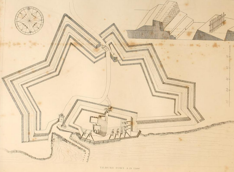
When Elizabeth became queen in 1558 the Tilbury blockhouse was repaired and re-armed with additional reinforcements during the threat from the Spanish Armada in 1588. The following plan from The History of the Town of Gravesend by Robert Peirce Cruden shows the site in 1588 with the blockhouse in the lower centre surrounded by embankment defences.

Tibury_Fort_AD_1588

The site was completely rebuilt after the 1667 Dutch attack, with construction commencing in 1670 and completion in 1685 resulting in one of the most powerful forts in the country, equipped to protect the City of London, the docks and industries along the river from any attacking force that ventured up the Thames. The new Tilbury Fort also included major defences to protect the fort against any land based attack.

It is this Tilbury Fort which is still substantially in existence today.

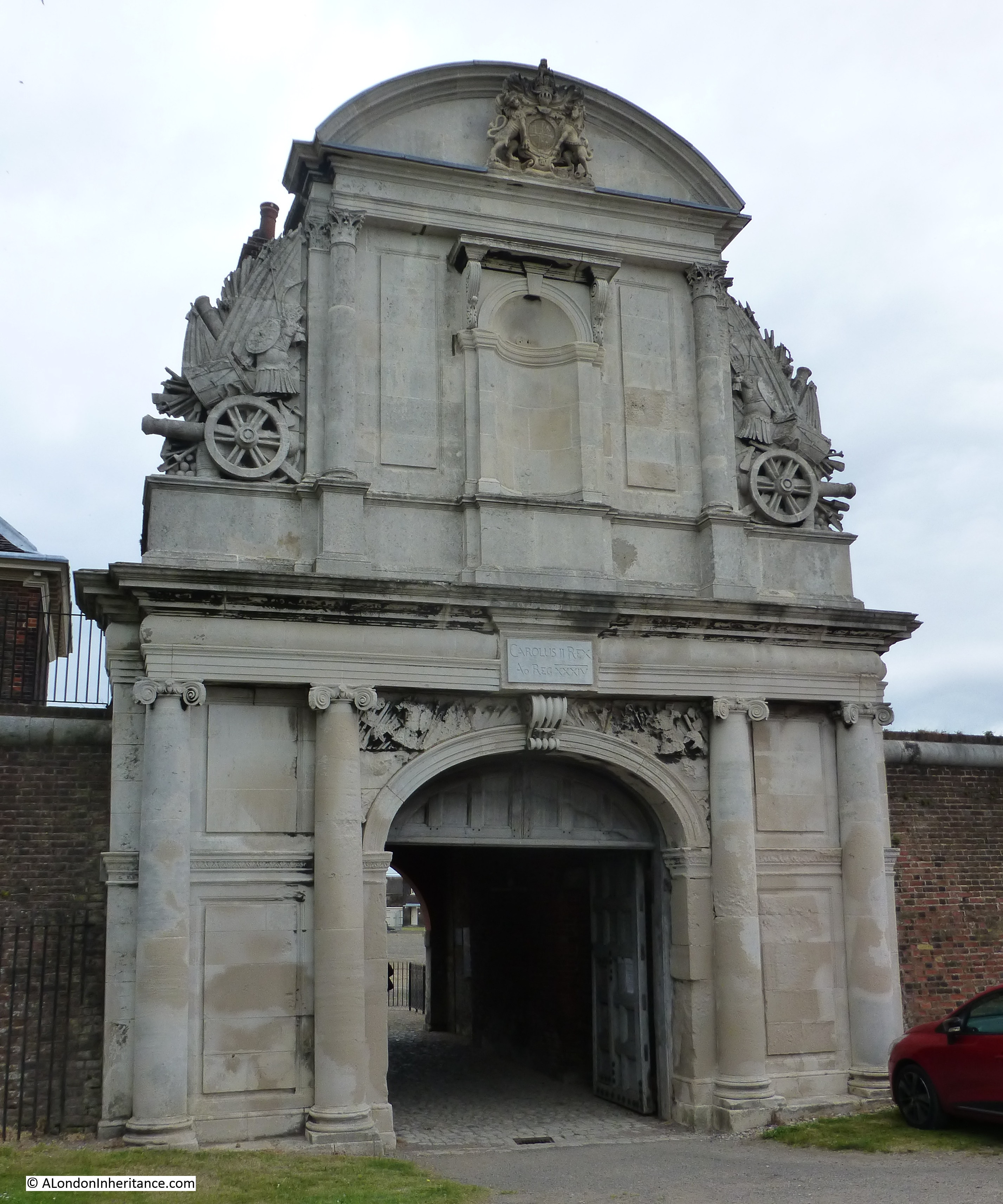
Approaching Tilbury Fort today, walking alongside the River Thames, entrance is through the ornate Water Gate, completed around 1682. The plaque above the main entrance reads “Carolus II Rex” – Charles 2nd and there was probably a statue of the King in the niche above.

Tilbury Fort 1

The Water Gate stands out well in this 1849 painting by Clarkson Frederick Stanfield titled Wind Against Tide (source: commons.wikimedia.org – click on image for original link) showing the fort on the right with shipping on the river experiencing rather rough conditions.

Tilbury_Fort_-_Wind_Against_Tide_by_Clarkson_Stansfield,_1849

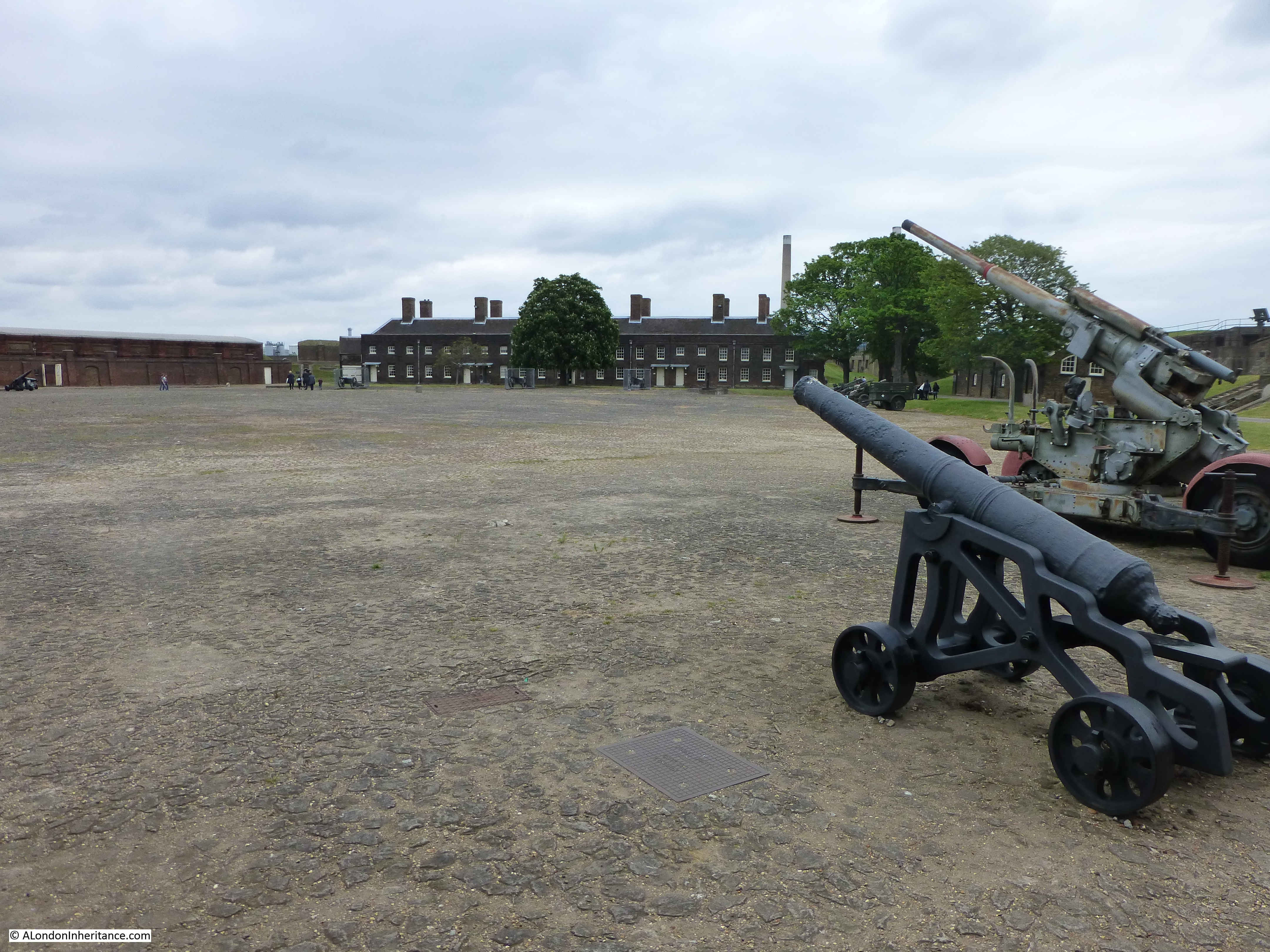
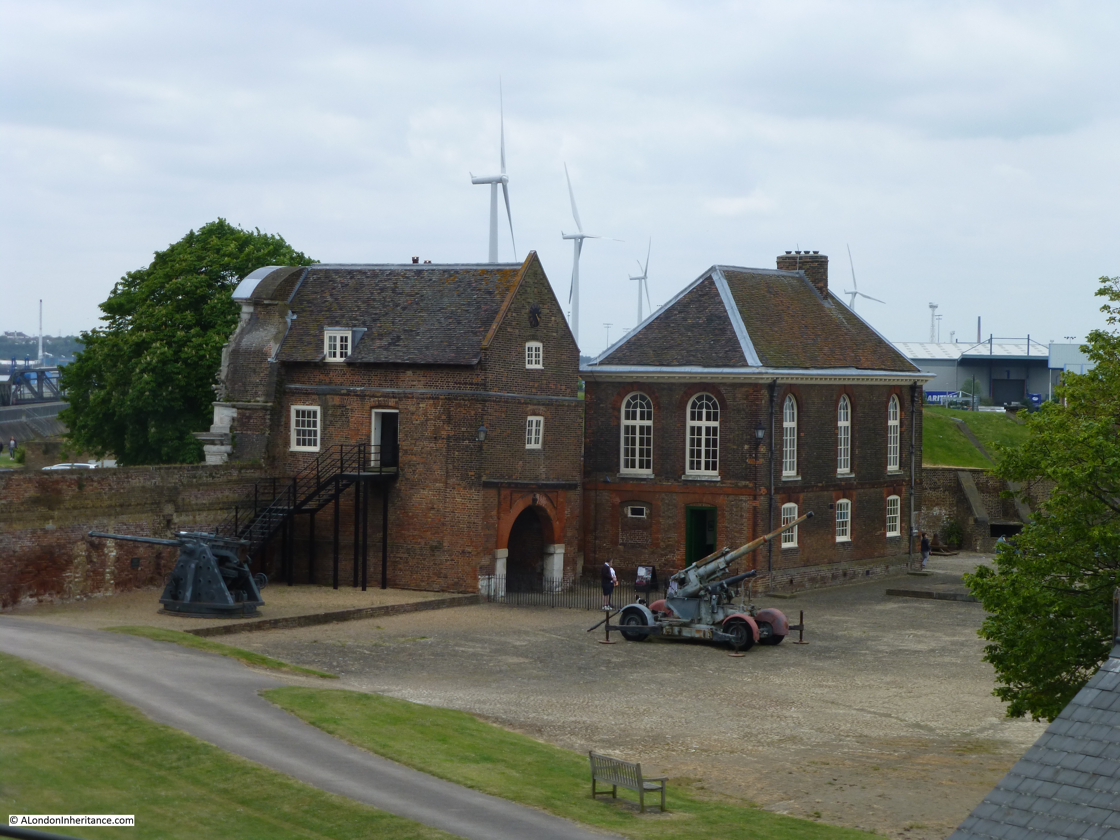
On entering the fort, the large parade ground gives an indication of how many soldiers would have been stationed here at the height of operations. Throughout the life of Tilbury Fort, numbers were in the range of between 100 and 300.

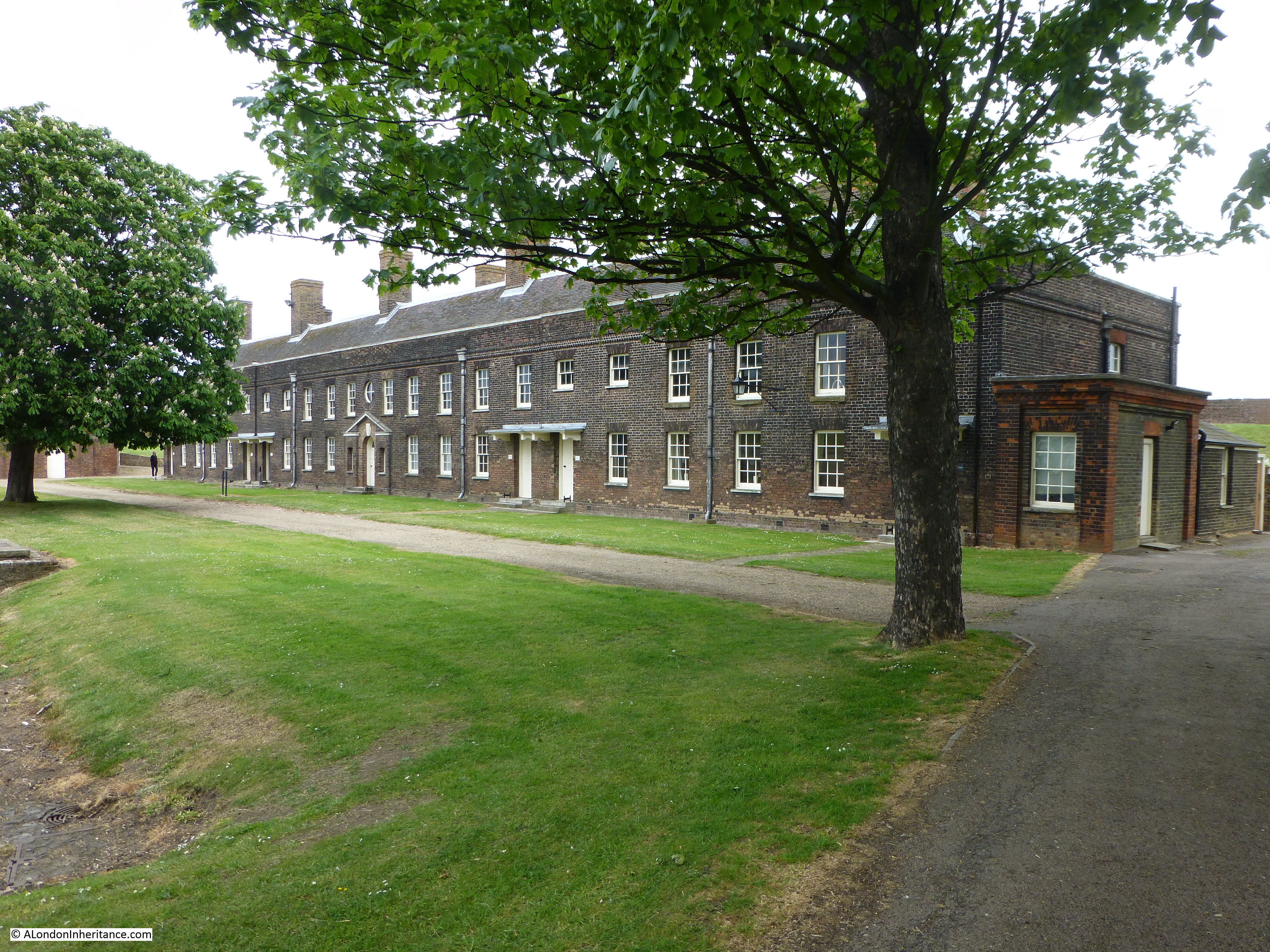
The officers barracks are at the back of the parade ground.

Tilbury Fort 2
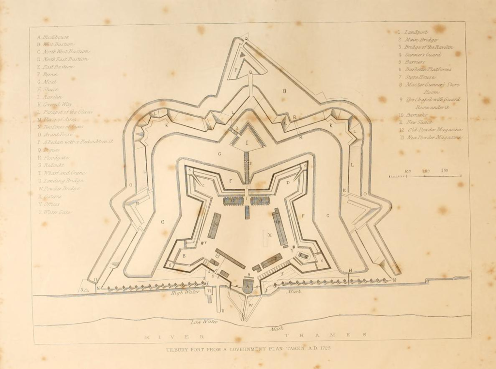
The layout of the rebuilt Tilbury Fort and the considerable defences can be seen in this plan of the fort in an engraving from a 1725 plan from The History of the Town of Gravesend by Robert Peirce Cruden. The Water Gate is at the lower centre of the plan. Note the markings for low and high water showing that at high water the river originally came up to edge of the fort.

Tibury_Fort_AD_1725

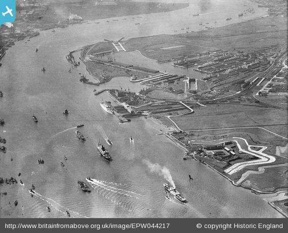
It is hard to get an impression of the overall scale of the fort from ground level. The following photo is from the Britain From Above website and was taken in May 1934. Tilbury Fort can be seen at the lower right of the photo. The defensive moat that runs around the fort was partially dry at the time and shows up as white. The Tilbury Docks can also been seen, along with a considerable amount of shipping in the river between Tilbury and Gravesend on the opposite shore.

EPW044217As well as defending the river, Tilbury was also a mustering point for soldiers from London.

In March 1587, Queen Elizabeth 1st requested the City to provide a force of 10,000 men, fully armed and equipped. The following table lists the numbers of men from each individual ward:

Farringdon Ward Within 807 Broad Street 373
Bassishaw 177 Bridge Ward Within 383
Bread Street 386 Castle Baynard 551
Dowgate 384 Queenhithe 404
Lime Street 99 Tower Street 444
Farringdon Without 1264 Walbrook 290
Aldgate Ward 347 Vintry 364
Billingsate 365 Portsoken 243
Aldersgate 232 Candlewick 215
Cornhill 191 Cripplegate 925
Cheap 358 Bishopsgate 326
Cordwainer 301
Langbourne 349
Coleman Street Ward 229 Total 10007

These numbers give some idea of the population density of each of the wards, The Earl of Leicester was in command at Tilbury and received 1000 of the London force, only on the condition that they brought their own provisions.

The description of their arrival at Tilbury gives the impression of  London men being dressed for show, rather than for work and fighting:

“The London men wore a uniform of white with white caps and the City arms in scarlet on back and front. Some marched in companies according to their arms. Their officers rode beside the men dressed in black velvet. They were preceded by billmen, by a company of whifflers (trumpeters) and in the midst marched six Ensigns in white satin faced with black sarsenet and rich scarves The dress of the officers and men was just as useless and unfit for continued work as could well be devised. It is melancholy to find that the Earl of Leicester who was in command at Tilbury held a very poor opinion of the London men.”

It was also at West Tilbury that Elizabeth 1st met the Earl of Leicester on the 8th August 1588 and the following day addressed the troops with the speech:

“And therefore I come amongst you at this time, not as for my recreation or sport, but being resolved, in the midst and heat of the battle, to live or die amongst you all, to lay down, for my God, and for my kingdom, and for my people, my honor and my blood, even the dust. I know I have the body of a week and feeble woman; but I have the heart and stomach of a king, and of a king of England, too; and think foul scorn that Parma or Spain, or any prince of Europe, should dare to invade the borders of my realms; to which, rather than any dishonour should grow by me, I myself will take up arms.”

Although there are a number of different versions of this speech, the evidence appears to be strong that Tilbury was the location where Elizabeth 1st addressed her troops at the time of the Armada.

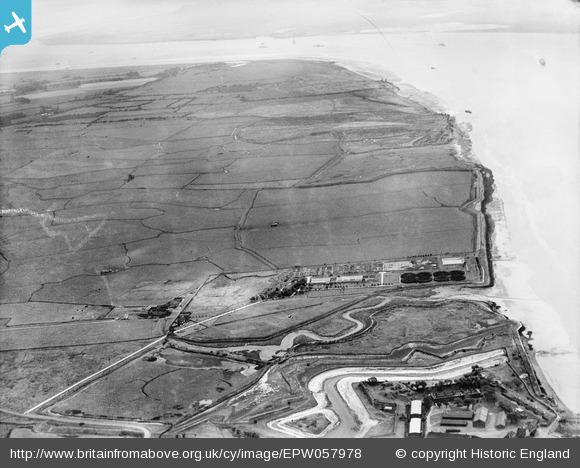
For those stationed at Tilbury Fort, it must have seemed a remote and barren location. Today, the fort is surrounded by docks and a power station, but up to the building of the docks the area was mainly barren, flat land. To get an idea, the following photo from 1938 is also from Britain From Above and shows the fort in the bottom right hand corner with only a water treatment works before flat fields stretch into the distance. Much of this is now occupied by Tilbury Power Station.

EPW057978

At the far end of the parade ground are the officers barracks. These were originally built in 1685, rebuilt in 1772 with further modifications during the 19th century. These barracks would have been used by the senior officers along with their families. Unfortunately the solders barracks were demolished in the early 1950s. They also faced onto the parade ground.

Tilbury Fort 3

There is an interesting connection between Tilbury and Greenwich. When Charles II approved the construction of the Royal Observatory at Greenwich, the King allowed £500 towards the new building, together with a supply of bricks from Tilbury Fort, where there was a spare stock, so some of the fabric of both locations is from the same stock of bricks.

As well as acting as a mustering points for troops, the main function of the fort was to protect the river.

Tilbury is the point in the Thames where the river starts to narrow on the approach to London, so it is an ideal location to site guns to fire at any invading ships attempting to move up river. Gun emplacements are arranged along the fort providing firing points looking across the river with Gravesend in the background:

Tilbury Fort 8

Shipping still passes Tilbury Fort, but of a very different type from when the fort was in use:

Tilbury Fort 9

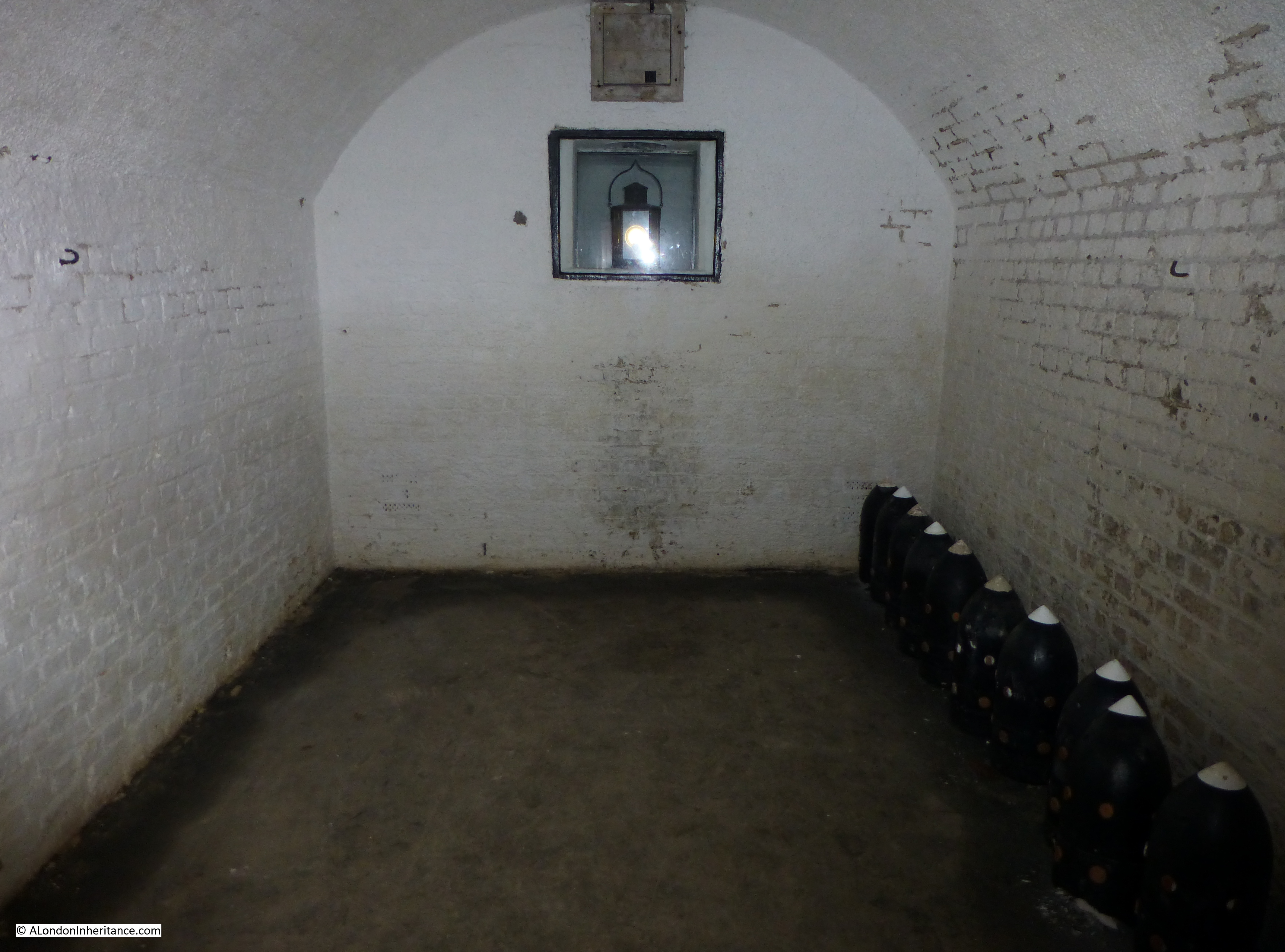
The fort also stored a considerable amount of gunpowder and munitions, both for use in the fort and as a general reserve for the army. Two magazines held large quantities of gunpowder. These are the only powder magazines to remain in Britain from the early 18th Century. Very strong, with a large blast wall around the perimeter.

Tilbury Fort 10

As well as gunpowder, munitions were stored in tunnels constructed under the earthworks. One of the tunnels leading to storage rooms for artillery shells and other munitions:

Tilbury Fort 6

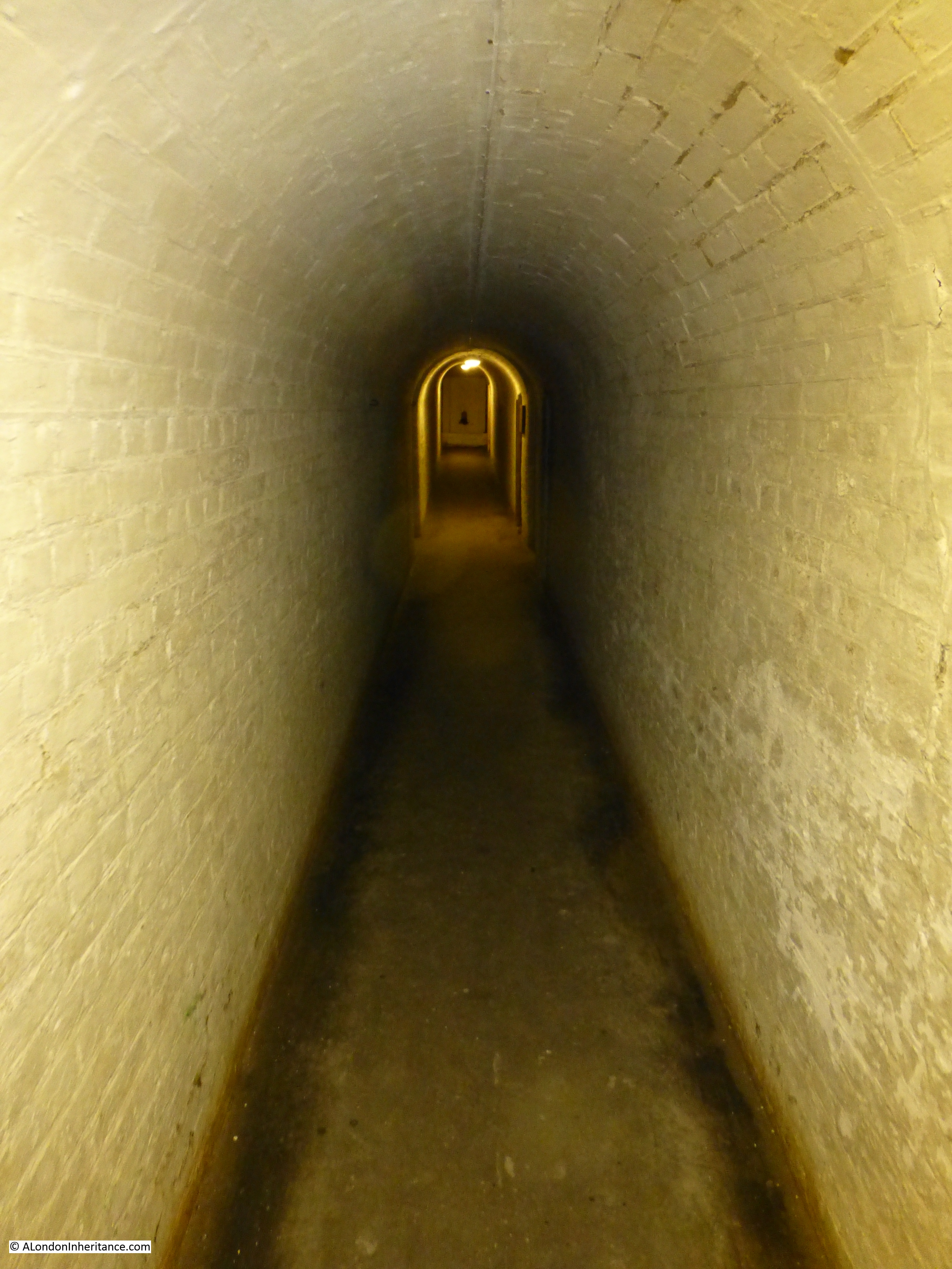
One of the storage rooms leading off the tunnel:

Tilbury Fort 7During the 18th and early 19th centuries there was the occasional threat of an attack on London via the river, although the majority of wars were being fought on the continent or at sea.

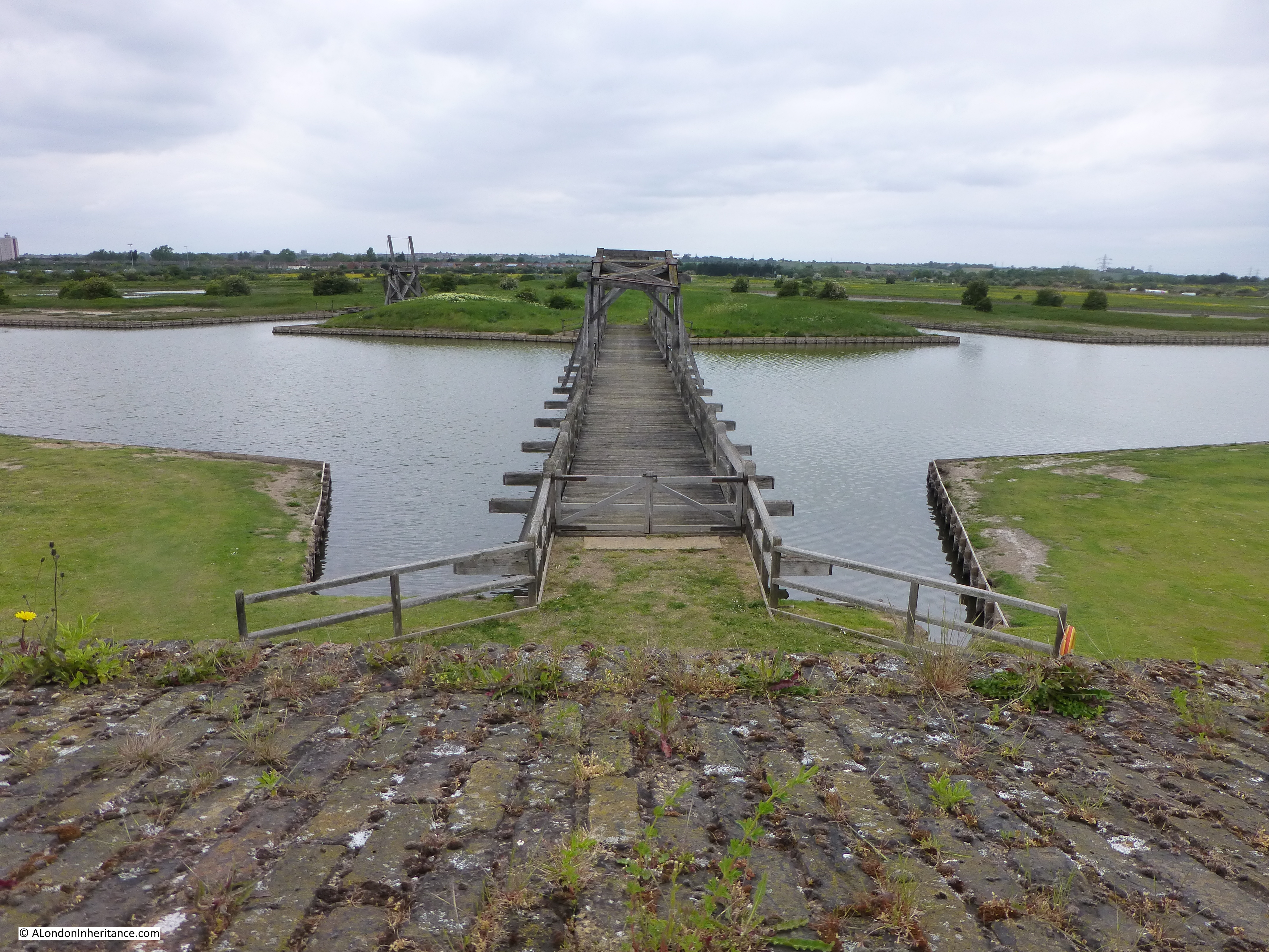
Tilbury Fort was permanently manned with numbers being ramped up or down dependent on the perceived threat level. The troops at the fort were also responsible for defending the fort and surrounding area from any land based attack. The fort was very well protected from land based attack with a series of moats and land defences. To the rear of the fort, a reconstructed bridge leads across to one of the island defensive locations, then on to the flat lands north of the river.

Tilbury Fort 4

Soon after the Jacobite rebellion of 1745-6 Tilbury Fort was used as a prison for survivors of the rebellion whilst they waited for trial in London. Off 303 that sailed from Inverness, 268 survived to Tilbury. They were imprisoned in the gunpowder magazines in such dreadful conditions that a further 50 died. After trial in London in 1747 they were either executed or transported to Barbados and Antigua to work on the sugar plantations as slave labourers.

Another view inside the fort. The Water Gate is on the left with the guard-house and chapel on the right:

Tilbury Fort 5

The gunpowder held at the fort was used for many purposes. In May 1838 the Brigg, William had been run down by a steamer opposite the fort and was causing an obstruction in the river. The people of Gravesend petitioned the Government to have it removed and a party of sappers and miners led by a Colonel Paisley arrived to sink a large amount of powder under the wreck by means of a diving bell. A special fused pipe led to the surface allowing the fuse to be lit from the surface and the sappers to get back to shore in time. There was an “awful explosion” with “waters rising mountains high followed by clouds of black coal and pieces of wreck”.

Tilbury Fort continued in use throughout the 19th century with occasional upgrades as technology provided new and more efficient guns and threats changed, however by the start of the 20th century naval technology had increased so much that large shore forts along the river had become obsolete and naval protection of the Thames was considered a more effective form of defence.

The fort continued to be used for storage and also as a transit centre for troops, a key role during the 1st World War, given the adjacent port of Tilbury.

During the 2nd World War, the fort had a brief role as an anti-aircraft operations centre, controlling the fire from guns along the river.

Tilbury Fort finally ceased any military role in 1950 when it was transferred into the Ministry of Works as a historic monument and the fort is now in the care of English heritage.

alondoninheritance.com

2nd June 1953 – Coronation Day In London

The 2nd of June 1953 was Coronation Day in London and a public holiday. As usual for such an event, people started lining the route between Buckingham Palace and Westminster Abbey well before the procession to ensure a good position to see the new Queen.

The weather during the previous May had been excellent with lots of warm, sunny weather broken only by the occasional thunderstorm. This weather broke by the end of May, for the last week of May and the rest of June the country was under many low pressure areas moving from the Atlantic bringing cold temperatures for June and rain.

My father took a number of photos of people as they lined the route, along The Mall and round into Trafalgar Square.

These show people wrapped up for the weather and rather more formally dressed than you would find at such an event today.

This photo was taken in The Mall. They look well prepared for the wait. The man is obviously not interested in people watching, he looks engrossed in his book. The group in the background also seem very well prepared judging by the number of boxes they have.

Coronation 1

Sleeping in The Mall:

Coronation 2

Again in The Mall and the crowds are growing. In the top left is the faint outline of one of the arched decorations that spanned The Mall:

Coronation 3

A wider view of a very busy Mall.

Coronation 7

The morning of the 2nd of June was more like an autumn day with rain showers and temperatures reaching only 12 degrees centigrade. Very low for early June.

This is Trafalgar Square. On the left is one of the commentary boxes set-up along the route. This was the first Coronation to be televised.

Coronation 4

Photo of the small group of people on the lion. Not sure how long the man on the far left was going to balance in that precarious position:

Coronation 5

Another view of the same scene:

Coronation 6

These two look cheerful despite the long wait and the weather:

Coronation 8

The newspaper between them was the Daily Mirror from the 29th May. The headline “The Shame Of Piccadilly” and “The rich street forgets” refers to the complete lack of decoration in Piccadilly for the Coronation. There are two photos on the page. The top photo shows Piccadilly without any decoration, the bottom photo shows, what is assumed to be an ordinary working class street decorated with flags and bunting and a Long Live The Queen banner stretched across the road. (I also have a series of photos taken in Hoxton showing the street decorations – a subject for a future post)

Coronation 10

Another group reading and watching the world go by:

Coronation 9

Some of the elaborate decorations that lined the Coronation route:

Coronation 11Coronation 12Coronation 13The expectation at the time was of a new Elizabethan era with comparisons back to Queen Elizabeth 1st as shown by the following tableau along the route of the procession. The text on the left is abbreviated from a speech given by Queen Elizabeth 1st to the Houses of Parliament on April 10th 1593 (1558 was the year that Elizabeth 1st became Queen) and that on the right from Queen Elizabeth 2nd from her first Christmas broadcast in 1952. Coronation 14

For those lining the route of the procession, I suspect that despite the weather, it was an event that was well worth the wait and long remembered.

alondoninheritance.com

London Streets In The 1980s

The 1980s in London was a decade of considerable change. Long established industries, street scenes, shops and ways of life were being swept away and the often divisive politics of the time were visible painted along the walls.

The mid 1980s are only 30 years ago but walking along London’s streets today I still find it surprising how considerable the change has been in many areas.

For this week’s post, I would like to take you back through a snapshot of London Streets in the 1980s, with some of the photos we took, mainly of south, east and north London.

Local, independent shops once served the majority of London’s residents, often run by the same family for many years. Many of these were in their final years, clinging on whilst much around them had closed:

Street Scenes 1


Street Scenes 4


Street Scenes 5

Many had already long closed, waiting for demolition and the rebuilding of whole streets:

Street Scenes 18

What Londoners would look for when eating out would also soon change. This was before the streets were populated with identical coffee shop brands:

Street Scenes 19

The corner shop was a standard feature of many residential streets. Many of these had closed or were put into some temporary use whilst awaiting either redevelopment or demolition:

Street Scenes 20


Street Scenes 21

A somewhat forlorn tribute to West Ham waits for what will become of these buildings:

Street Scenes 22

The Isle of Dogs is an area where much has changed beyond all recognition. Here a newsagent has found a novel way of continuing business using a shipping container:

Street Scenes 16

But there were large areas of the Isle of Dogs where businesses had closed down for good:

Street Scenes 15

Much of the old industrial and dock areas of the Isle of Dogs were a wasteland with the redevelopment of Canary Wharf, housing and riverside apartments yet to come. Closed gates, vacancy signs that would never again advertise another vacancy sat alongside graffiti that emphasised the perceived lack of concern from the government of the time to the plight of those affected:

Street Scenes 14

There had also been the rise of far right groups. Joe Pearce was imprisoned under the Race Relations Act for publishing the Bulldog magazine and became a cause celebre for these groups. Free Joe Pearce slogans could be found across the east of London, usually with a different slogan added underneath by groups opposing the far right:

Street Scenes 17

Whilst for some groups, anarchy was the only route:

Street Scenes 23

The start of redevelopment was also in evidence across the Isle of Dogs. This is Maconochies Wharf  where clearance and preparation was underway for the building of houses. A mural on the adjacent building emphasising the historical traditions of the Isle of Dogs:

Street Scenes 26

Street advertising for cafes and restaurants was much in evidence. This one in central London at Holborn – the “Perfect Businessman’s Venue” where you could get a 3 course set menu for £7.50

Street Scenes 13

Similar advertising signage could be seen across London’s streets:

Street Scenes 3

At least they were very colourful, even if the representation of what was on offer was probably not very accurate:

Street Scenes 11


Street Scenes 6


Street Scenes 12

This was a time when murals were very much in evidence. Ranging from those that would cover the whole side of a building:

Street Scenes 24

Street Scenes 25

More London Murals from the 1980s can be found in one of my earlier posts here.

Through to more individual efforts:

Street Scenes 8

Signs from a much earlier period were also much in evidence on buildings that would soon be lost:

Street Scenes 7

Only 30 years ago, but in many ways the London Streets in the 1980s were very different to those of today.

alondoninheritance.com

A Walk Round The Shell Centre Viewing Gallery

Shell Centre is an office complex on the Southbank, located between Hungerford Bridge and the old London County Council building. The most obvious part of the complex is the 26 storey tower.

Designed by Sir Howard Robertson and built between 1957 and 1962 for the Royal Dutch Shell group of oil companies, the office complex set new standards for staff facilities and building automation. Originally two main blocks, one either side of Hungerford Bridge, the “downstream” building to the east of Hungerford Bridge was sold during the 1990’s and converted to apartments.

Although large buildings above ground, there is a significant part of the complex below ground with a large swimming pool, theatre and bar being among the facilities for the original 5,000 staff to enjoy. Two underground tunnels connected the upstream and downstream buildings, running underneath the rail arches leading to Hungerford Bridge and being just above the underground train tunnels running north from Waterloo.

The building also had a tunnel out to the Thames so that river water could be used for cooling.

The “upstream” building to the west of Hungerford Bridge has a “U” shape set of 10 storey offices with the 26 storey, 351 foot tower block being the most obvious feature of the complex.

Shell has temporarily moved out of the complex and there is a proposed redevelopment of the site that will significantly change this part of the Southbank, more on this at the end of this post.

Long before the Shard and the Sky Garden at 20 Fenchurch Street, one of the innovations for the time was that the tower had a public viewing gallery. This was when there were very few tall buildings across London and certainly nothing built or planned in this part of the city. The viewing gallery provided almost continuous all round views of London.

The viewing gallery closed not that long after opening. I was told this was because that sadly there had been a suicide (although I have no verification of this). I was able to visit the viewing gallery in 1980 and took the following photos which show a very different London skyline to that of today. It always surprises me that it was not that long ago that there were very few tall buildings across London.

We will start with the view across to the Houses of Parliament and walk round the viewing gallery.

This was long before the construction of the London Eye which would now be the main feature of this view:

Shell Centre Viewing Gallery 3

Moving further to the right we can look straight across the river. The large building to the right are the offices of the Ministry of Defence. Buckingham Palace is to the left of centre:

Shell Centre Viewing Gallery 15

And further to the right, this is the original Charing Cross Station at the end of Hungerford Railway Bridge. In the years after this photo was taken, in common with many other main London stations, office buildings were constructed on top of the station. This was also before the Golden Jubilee foot bridges were added to either side of Hungerford Railway Bridge. At the time the photo was taken there was a single, relatively narrow foot bridge on the east side of the bridge.

Shell Centre Viewing Gallery 4

Looking directly onto Charing Cross Station with the Post Office Tower in the background and Centre Point to the right:

Shell Centre Viewing Gallery 2

Further to the right, the building left of centre is Shell-Mex House. This was occupied by the UK operating company of Shell. To the right is Waterloo Bridge.

Shell Centre Viewing Gallery 14

And further to the right with the full width of Waterloo Bridge:

Shell Centre Viewing Gallery 13

We are now starting to look over towards the City of London, St. Paul’s Cathedral can be seen to the upper right of centre and the three towers of the Barbican to the left.

The L shaped building in the lower foreground is the downstream building of the Shell Centre complex, and just above this building is the tower that was for London Weekend Television. The base of this tower still consists of TV studios, one of the few buildings that have had the same function over the last 35 years.

To the right of this is Kings Reach Tower, occupied at the time by IPC Magazines, publishers of magazines ranging from Loaded to Country Life. IPC Magazines vacated this tower block some years ago and it is now in the process of being converted into, yes you have probably guessed, more apartments. The height of the building is being raised with additional floors being constructed in top.

Shell Centre Viewing Gallery 7

And slightly further to the right, the tower in the distance was at the time the tallest office block in the City of London, the recently completed NatWest Tower, built for the NatWest Bank, now renamed as Tower 42.

Shell Centre Viewing Gallery 1

This photo is looking down onto the roundabout at the southern end of Waterloo Bridge. The large space in the centre of the roundabout is now occupied by an IMAX Cinema. The church to the right is St. John’s, Waterloo. The church was built between 1822 and 1824 and due to the marshy land had to be built on piles.  I was told at the time that one of the reasons for so much space below ground level at Shell Centre was also due to the marshy ground and the need to keep the overall weight on the site equal. Excavating below ground level to remove sufficient weight of earth equal to the weight of building on top. No idea if this is true, but it does seem plausible.

Shell Centre Viewing Gallery 5

This photo is looking straight across to the City and Southwark. There is nothing of any height in the far distance. The buildings of Canary Wharf would now be very visible in the distance.

Shell Centre Viewing Gallery 9

Continuing to move to the right, this is looking over south-east London with the roof of Waterloo Station occupying the bottom right corner of the photo.

Shell Centre Viewing Gallery 8

And round to the right again looking over south London with the extensive network of tracks leading into Waterloo Station. The lower section of tracks at the bottom part of the photo would soon be converted to the London terminus of Eurostar prior to the completion of the HS1 rail route which transferred Eurostar trains into St. Pancras.

Shell Centre Viewing Gallery 11

Detail from the above photo showing British Rail rolling stock prior to privatisation of the rail network:

Shell Centre Viewing Gallery 18And a final view over to south west London. This was as far as the viewing gallery would allow, the gallery did not run along the western side of the tower:

Shell Centre Viewing Gallery 12

I cannot remember why I was using Black and White film when I took these photos from the viewing gallery. Shortly after taking the above, I took the following photo in colour showing Shell Centre from the north bank of the Thames. The north facing part of the viewing gallery can be clearly seen at the very top.

Shell Centre Viewing Gallery 17

The building is one of the few immediate post war developments that works well. If the proposed redevelopment of the site gets approval, it will be very different. The plans propose the demolition of the “U” shaped 10 storey office block at the base of the tower, and a whole new cluster of towers built around the original tower.

To see the proposed development, look here.

It was quite a surprise to see how much this area will change, and in my view, the close proximity of towers of very different materials and design to the original tower just does not look right.

It was fascinating to look back on these photos of the London skyline from 1980. It looks very different now, and the almost continuous development of tower blocks look set to continue transforming the skyline for many years to come, although unlike the original Shell Centre complex, with almost identical glass and steel towers that are removing so much of the local character of London.

alondoninheritance.com

A Brief History Of Aldersgate Street

The following photo is from 1947 and shows a street with a very large heap of rubble on the land to the right. When I scanned this negative, I was doubtful as to whether I would find the location. There appears to be a sign on the wall to the left of the pillar in the centre of the photo, but this cannot be read when zooming in due to the definition within the original 35mm film stock.

I was sorting through some boxes with photos that my father had printed from the original negatives and I found the same photo, and on the rear was written Aldersgate Street.

Although I cannot be sure where on Aldersgate Street the photo was taken, I am very sure that it is looking north. Most of the wartime damage in this area was to the east of Aldersgate Street on the land that would be redeveloped as the Barbican estate. The west, whilst suffering bomb damage did nor suffer the same extensive fire damage caused by incendiary raids. including the one on the 29th December 1940.

The huge heap of rubble must be from the buildings demolished on the future site of the Barbican. Comparing the height of the rubble with the lamppost gives some idea of how much must have been removed from the site.

Aldersgate 1

It is impossible to know exactly where on Aldersgate Street this photo was taken, but to give an idea of how the area looks now, I took the following photo on Aldersgate Street, looking north. The Barbican development is on the right. The road has been considerably widened, and the photo would have been somewhere along this scene.

Aldersgate 2

Aldersgate Street is an old street and was so named after the northern gate of the city.

Although originally it did not go any distance as Bishopsgate received the traffic from the north, Aldgate from the east, Newgate from the west and Bridge Gate from the south.

Aldersgate appears to have simply opened out upon moor land, but gained greater significance when it was used as an access point to Smithfield when the area began to be used as a market for horses and cattle and a number of religious establishments.

In researching the street, there are a few very different explanations for the name.

Starting with Stow, whose Survey of London is used by many later historians as a source of historical fact, Stow states that:

“The next is AEldresgate, or Aldersgate, so-called not of Aldrich, or of Elders, that is to say, ancient men, builders therefore, nor of Eldarne trees, growing there more abundantly than in other places as some have fabuled, but for the very antiquity of the gate itself, as being one of the first 4 gates of the city and serving for the Northerne parts, as Aldegate for the East.”

Walter Thornbury in Old and New London partly quotes Stowe:

“Aldersgate was one of the four original gates of London, and formed the extreme corner to the north. Some say it was named after Aldrich, a Saxon, who built it; others, says Stowe attribute it to the Alder trees which grew around it.” 

Sir Walter Besant writing in 1910 in his History of the City of London states:

“Stow’s derivation from the “Elder” or “Older” gate is too far-fetched. It is named probably from one Ealdered, its earliest name being “Aldredesgate”.

Two books published in the early 20th century give different interpretations. Harold Clunn in the Face of London writes:

We pass next to Aldersgate Street. This thoroughfare is so names from the northern gate of the City, the name of which in turn is derived from the alder trees which once grew around the gate”.

Whilst Gertrude Rawlings writing in The Street Names of London states:

“In the laws of Ethelred, c 1000, Ealdredsgate (and variations). The gate of Ealdred or Aldred, a Saxon Londoner of whom nothing more is known.”

A number of recent London street name books I have checked seem to be playing safe by not including Aldersgate Street.

I am inclined to go for the Saxon name of Ealdred or Aldred as the source of the name. Fascinating to think that someone living at that time could have given his name to one of London’s major streets, but it also demonstrates the difficult in establishing the truth behind many of the older street names in London and that you should not always believe the explanation given in a single book, always best to seek as much evidence as possible.

It is interesting to understand what was on the east site of Aldersgate Street as a large network of streets were lost under the Barbican development.

The following map is from the 1940 edition of Bartholomew’s Reference Atlas of Great London. Unfortunately this area is to the edge of the page, but it does show that to the east of Aldersgate Street were a network of streets and courts. All of these have since disappeared, indeed the only remaining landmark is the Ironmongers Hall which is still there, hidden behind the Museum of London which has been built over Maidenhead Court and Blue Lion Court.

Aldersgate 6

The 1910 map published alongside Besant’s History of the City provides more detail of the network of streets and courts to the east of Aldersgate Street:

Aldersgate 5

Going back further to John Rocque’s map of London published in 1746, Aldersgate Street is also on the edge of the map sheet, but we can see the network of streets and courts on the east side that had already been in place for many years, and would last to the second half of the 20th century:

Aldersgate 3

Going back further, Aldersgate is mentioned many times in medieval records, for example:

In 1339 the Chamberlain of Guildhall spent 20s and 4d on the pavement of the gate of Aldersgate, the pavement being one of cobbled stones laid close and rammed. This being an indication that there was a good amount of traffic through Aldersgate as money was only spent on the provision of a cobbled pavement where there was significant traffic.

In 1346 a certain Simon is hanged for robbery at Aldersgate.

In 1350 there are records of the shops within Aldersgate.

In 1391 a scrivener stands in a pillory without Aldersgate for forgery.

The original gate at Aldersgate was in a very bad state by 1510. Recorded in the Presentment of the Wardmote Inquest of the Ward of Aldersgate is:

“Item: we present Aldrygegate in Joberdy of fallyng downe, yt synkys so sore”

The original gate was taken down in 1617 and rebuilt to a new design. In honour of the king an equestrian statue was included in the new gate just above the arch. The cost of the new gate was £1,000 and was funded by a bequest from a certain William Parker, Merchant Taylor.

The new Aldersgate gate:

Aldersgate 7

William Maitland’s History and Survey of London from 1756 provides a view of how the ward was kept safe at night:

“There are to watch at Aldersgate, and other stands in this Ward, every Night, one Constable, the Beadle, and 44 Watchman. And in the liberty of St Martins-le-Grand, which is in this Ward, 12. In all 56.”

Maitland also described the state of the street in 1756:

“Aldersgate Street, very spacious and long, and although the Buildings are old, and not uniform, yet many of them are very good, and well inhabited.”

The gate at Aldersgate was removed in 1761. As with other City gates, it was too narrow and restricting on the amount of traffic that was now travelling in and out of the city.

To mark the northern limits of the City, two pillars were erected in 1874 as shown in the following drawing from the time, looking down Aldersgate Street with St. Paul’s Cathedral in the distance:

Aldersgate 4

The 1932 edition of The Face of London provides a view of Aldersgate Street shortly before the last war:

“Thirty years ago Aldersgate Street was a shabby thoroughfare, but during our own century it has greatly increased in importance. On the west side, at the corner of Long lane, is the Manchester Hotel, and next door is the Metropolitan Railway station which was opened for traffic in 1865.”

As with many other streets across London, the coming of the railway provided an incentive for new developments and new trades in the local area.

The same book also states that in 1932 the Corporation of London was considering an investment of £1,500,000 to widen Aldersgate Street to 80 feet from St. Martins le Grand to Goswell Road as the road was very narrow.

The wartime devastation to the east of Aldersgate Street shown in my father’s photo at the start of this article provided all the opportunity needed to widen the road, and it is this incarnation of Aldersgate Street that we see today.

The sources I used to research this post are:

  • Old and New London by Walter Thornbury published in 1881
  • London, The City by Sir Walter Besant published in 1910
  • The History of London from its Foundations to the Present Time by William Maitland published in 1754
  • The Face of London by Harold P. Clunn published in 1951
  • Stow’s Survey of London . Oxford 1908 reprint of 1603 edition
  • The Streets Names of London by Gertrude Burford Rawlings
  • Bartholomew’s Reference Atlas of Greater London published in 1940

 alondoninheritance.com

VE Day In London – 1945 And 2015

Friday, 8th May was the 70th anniversary of Victory in Europe Day, or VE Day, the day in 1945 when the war in Europe officially came to an end. There are plenty of photos and film showing the celebrations in London on the day and throughout the night. The lights are starting to come back on and crowds throng the West End.

Apart from being evacuated for a couple of weeks at the very start of the war, my father lived in London throughout, in flats which still exist, just off Redhill Street in Camden. As well as a large collection of photos, he also left a detailed account of his experiences in London during the war. Written shortly after, these tell of the horror and also the sense of adventure that comes from the perspective of someone growing up in London.

His account finishes with a few paragraphs covering VE Day, written from the perspective of someone who has spent all their teenage years in London during the war, and for that generation, VE Day meant not going back to normal, but rather a future with plenty of uncertainty.

I decided to take a walk on Friday night and follow his footsteps exactly 70 years after his walk through London on VE Day, 1945, but before my account, the following is how my father saw VE Day on the 8th May 1945:

So now the long war was finally over, in Europe at least, which to many seemed the real war. Locally, as throughout the country preparations were quickly made for a celebration. Trestle tables magically appeared, placed end to end in the courtyards beneath the blocks of flats, where they could be fitted in between the surface shelters and the bicycle sheds, for a grand children’s party. Similarly, flags and bunting appeared at windows and were strung between balconies, reminiscent to me of my last children’s party, for the Coronation of 1937. Indeed, it was clear that cardboard cut-outs of their Majesties, together with slogans of “God Bless The King And Queen” had been safely stored since then.

Elsewhere bonfires in the streets were made ready for the evening of the 8th. A huge bonfire was prepared on part of Cumberland Market, the local boys dragging old doors and any timber they could lay their hands on to add to the pile.

As for myself, I had made arrangements with my friend Gus, whom I had known since infants school days, that on that evening, we would make our way to the West End to watch the celebrations.

Outrageous it may sound, but I didn’t feel like celebrating, and it became clear that Gus felt the same. The war had begun when I was eleven and, now being seventeen, the whole of those six years, despite every hardship, had been the only real and normal life that I could recognise, for I was a child before September 1939. therefore peacetime presented a prospect of the Great Unknown, in which the unity of wartime would vanish.

So it was that I felt a complete outsider, observing only the dancing, singing and general merrymaking taking place in the West End. Servicemen would now rightly look forward to a return to civilian life, with the promise of a better life than the one they had left; but with the war in the far east not yet over, Gus and I had to await our call-up to the services and I, as a temporary Civil servant, would be without a job to return to, if and when I did.

Darkness had fallen by the time we had managed to reach the end of Regent Street, where the crowds were vast and well lit by the unaccustomed brilliance from the lights, made even brighter by roving searchlights picking out the revellers for the benefit of the cine cameras.  On one of the balcony’s overlooking Piccadilly Circus, the musical star, Zoe Gail appeared, dressed in top hat and tails to sing “I’m Going To get Lit Up When The Lights Go On In London” which was rapturously received by the crowds.

However as observers, we eventually left the Circus, walking south along Regent Street to Waterloo Place. Here we came across the Athenaeum Club in Pall Mall, which to me presented the most spectacular illumination of the night. The building, constructed in Ancient Greek style, had been freshly painted a pale yellow colour and subtly lit. The balustrade bordering the Club surmounted by torches. Each had been filled with oil or similar and lit, producing a spectacular dish of flame, adding to the warm light bathing the building.

And so we made our way through central London taking it all in, the lights, the shop windows, the decorations and individual celebrations, until we found ourselves in Chiltern Street, which runs parallel with Baker Street. Celebrations at the London Fire Brigade building were well underway. The station gates were wide open and in the drill yard blazed a large fire. In one corner a piano was playing old favourites, while several elderly ladies performed a nifty “Knees Up Mother Brown”. We didn’t join in the dancing or sing any songs, but the beer and food was welcome, and I felt at home in the fire station.

Now the early hours of the morning, V.E. Day was over. we made our way home both wondering what life held in store for us.

Preliminaries to the 1945 General Election being contested by our great wartime leader, Winston Churchill, for me set the seal on the end of an era. I watched Churchill campaigning at Mornington Crescent, Camden Town, his open car surrounded by a rather hostile crowd. The great man was standing, raised hat in his left hand, cigar in his right. from an onlooker came a cry “Ere, Winston, try one of our fags!” followed by a Woodbine pack hurled at Churchill who turned the other cheek as his car drive on.

The future must have seemed very uncertain at the time. I suspect that he “felt at home in the fire station” was due to his grandfather, my great-grandfather being the Superintendent of East Ham Fire Station.

On Friday night, I set out from the West End to reach Chiltern Street by dusk and find out if the fire station was still there, and then walk back during the late evening to photograph the West End as it is now, very different to the same night 70 years earlier.

Turning off Baker Street and a short walk down to Chiltern Street, it was easy to spot the old Fire Station, the exterior looks much as it must have done when my father and Gus stopped here 70 years earlier, although now the building has a very different purpose. The building is now the Chiltern Firehouse, a bespoke luxury hotel and restaurant.

I took the following photo of the Fire Station as the light was fading on Friday evening. The original function of the building is very clear, the three large doors providing access to where the fire engines would have been waiting for a fast exit to the street.

VE Day 1

Just to the left of the main building is the old drill yard mentioned in my father’s account. This  also forms part of the Chiltern Firehouse and the original entrance still remains.

I stood for a while looking at what is a wonderful building, the architecture a clear statement of the standing in which the Fire Service at the time was held. As I waited, there was an almost constant stream of taxis dropping people off for either the restaurant or hotel and entering via the old drill yard entrance. Very different to the same place, 70 years earlier.

VE Day 2Pleased to have found that the Chiltern Street Fire Station building is still there, I then headed back through Manchester Square, to Oxford Street and then to the top of Regent Street.

In Regent Street looking back up to Oxford Circus:

VE Day 4Regent Street is still lined with shops as it was in 1945, but the shops are now rather different than they were. Walk down the street now and you pass the status shops of global brands:

VE Day 3

Shops with displays, variety and colour that would still have been a distant dream along the Regent Street of 1945:

VE Day 5

Regent Street is well-lit, but on reaching the end of this part of the street, the brighter lights of Piccadilly Circus beckon:

VE Day 6Piccadilly Circus is brilliantly lit at night and was one of the centres of celebration on the 8th May 1945. Late evening in 2015 and it is still busy, but nothing like the crowds my father was in, that were here in the same evening in 1945.

VE Day 7Eros as it is now generally known, or the Shaftesbury Memorial Fountain to use the original and full name is the focal point of Piccadilly, but sits almost in the shade of the surrounding buildings:

VE Day 8

Illuminated advertising has always been a central feature of Piccadilly Circus:

VE Day 9I followed my father’s route through Piccadilly Circus and down to the lower end of Regent Street to Waterloo Place.

Waterloo Place is at the junction of Pall Mall and Regent Street and leads down to the 1834 column that forms the monument to the Duke of York. Much quieter than Piccadilly Circus and Regent Street.

Steps lead down from Waterloo Place to The Mall and I can imagine that in 1945 this was a far busier celebration route from Buckingham Palace to Piccadilly Circus.

Looking from Waterloo Place, up Regent Street to Piccadilly Circus:

VE Day 10

The Athenæum Club still faces onto Waterloo Place and as my father described in 1945 is still “painted a pale yellow colour and subtly lit” although on this 8th May the torches, which can still be seen around the 1st floor balustrade were unfortunately not lit:

VE Day 11The Athenæum Club on the left with the Crimean War memorial in the centre of Waterloo Place, looking up to the bright lights of Piccadilly Circus:

VE Day 12He did not say where else he walked on VE Day, but having been in Waterloo Place, there is a good chance that he probably walked down to The Mall and to Trafalgar Square, so I took the same route. Looking from the centre of The Mall towards Admiralty Arch:

VE Day 13Flags on Admiralty Arch with the light from the searchlights in Trafalgar Square shining on the clouds. The searchlights had been set-up for the weekend as part of London’s celebrations of the 70th anniversary.

VE Day 14And in Trafalgar Square with the National Gallery in the background, the “V” searchlights pick out the top of Nelsons Column:

VE Day 15After Trafalgar Square I took a quick walk down to the footbridge alongside Hungerford Railway Bridge to see if the “V” searchlights from St. Paul’s Cathedral were visible. The view along the Thames to the City from here is fantastic during the day, but takes on an additional dimension at night. 70 years ago, this view would probably still have been dark, although searchlights that had been used a few years earlier to pick out enemy bombers were being used that night to illuminate the Cathedral.

VE Day 16And a final close-up clearly shows the V searchlights from St. Paul’s Cathedral:

VE Day 17It was fascinating to walk the same route as my father and his friend Gus, exactly 70 years later and consider how London has changed. I was really pleased to find that the Chiltern Street Fire Station is still there.

My father’s account of his life in London during the war was written soon after. The lack of much detail about VE Day itself, rather thoughts and concerns about the future probably reflect how many Londoners of the same age were feeling. After six years of war, the years of bombing, the V1 and V2, the threat to London had at last been removed, however the war in the far east was far from an end and National Service was imminent.

He did not take any photos on the night, as he did not get his first camera until 1946. When he did, one of the first photos was of St. Paul’s Cathedral lit up by searchlights. So, to finish off, this must have been how the Cathedral appeared on VE Day:

VE Day 18

alondoninheritance.com


The Royal Festival Hall – Dramatic Effects Of Space And Vista

I recently scanned some of my father’s photos which included the last photos he took in the early 1950s of the Royal Festival Hall. These photos show the area soon after the closure of the Festival of Britain when much of the infrastructure for the Festival was still in place.

At the end of this post I have put together a time sequence of photos of the site from 1947 through to 2015 showing the original site, during construction and photos taken in the early 1980s and 2015.

But first, the recently scanned photos, the first is of the Royal Festival Hall taken soon after closure of the Festival of Britain exhibition, from the footbridge alongside the Hungerford Railway Bridge.

Festival H4

And from the same location in April 2015:

Festival H6

The overall shape of the Royal Festival Hall is exactly as it was when first built, however there have been a number of cosmetic changes to the front with the middle tier window line now stretching across the full front of the hall and changes to the top tier with a balcony now between the glass and the front of the hall.

I planned to take the 2015 photo before the trees had come into leaf as when the leaves are fully grown the trees considerably obstruct the view of the hall. I was not early enough!

Please do not get me wrong, we do not plant enough trees, within the city and across the country, however there are some places where trees are in the wrong position. The Royal Festival Hall is, in my view, one of the very few buildings constructed soon after the last war that works well architecturally and is in the right location. The Royal Festival Hall was always designed to be seen from and across the River Thames and to provide views along to the City.

The trees in front of the building considerably obscure the building from the walkway across Hungerford Bridge and from the north bank of the Thames.

As the original Festival Guide stated:

“The Royal Festival Hall can claim to be a work of art in itself. The superb dramatic effects of space and vista, within the building and beyond it to the river and the city, are things which the visitor will discover for himself.”

Note also how in the original photo the Royal Festival Hall did not have any buildings in the background to detract from the view of the hall. A very different situation in 2015. To the right of the hall is the building that was the downstream building of Shell Centre, but has now been converted from offices to apartments. To the left is the Kent House Tower above the London TV Studios and behind that with the crane on the top is the South Bank Tower, again another building being converted from offices to apartments.

Walking a short distance further along the Hungerford footbridge, we can take a look down at the walkway in front of the Royal Festival Hall:

Festival H3

The poles are part of the decoration from the Festival of Britain. The photo also shows the observation platforms which I have heard of, but not seen photos of until scanning these negatives. There were six of these raised platforms extending just over the river wall and must have been a fantastic place to sit and view the surroundings.

At the far right of the photo is the Shot Tower, to the left can just be seen the walkway to the river pier, and in the distance is an excellent view over towards St. Paul’s Cathedral.

The view is very different in 2015:

Festival H7

The observation platforms are unfortunately long gone, and later replicas of the poles that can be seen in the original photo are just visible, however the view is considerably obstructed by the trees. Again, an example of why I would argue that this area of the Southbank is the wrong place for trees and their removal would open up both the view of the Royal Festival Hall and the views along the river and to the city.

The guide-book for the Festival of Britain shows the area in front of the Royal Festival Hall including the six observation platforms:

Festival H9

Walking almost to the end of the footbridge, we can look down and watch those out for a walk along the Southbank:

Festival H2

And the same location in 2015:

Festival H8

And a final view across to the Royal Festival Hall, with the Shot Tower on the left:

Festival H1

During the Festival, the Shot Tower had a Radio Telescope aerial mounted on the top. I had always assumed this was for decoration only, however the Festival Guide explains that it was a fully working system that would bounce radio signals off the moon, allowing visitors to see the time delay between the transmitted and reflected signal. The aerial system was mounted on a redundant gun mounting which could be moved to allow the aerial to track the moon.

From the Festival Guide Book:

“The Tower has been one of the landmarks of London since it was built-in 1826. It remains the only old building on the site, to serve as a beacon for the Festival. It is a beacon in two senses: it is a modern lighthouse with a double flashing beam welcoming visitors as far as 45 miles away when the weather is clear; it is a radio beacon directing radio signals to the moon and beyond into space.

The lighthouse mounted at the top will flash from sunset to Exhibition closing time. It has a power of 3 million candles. It is of the most modern all-electric design and so takes up far less space than the older types which needed weighty lenses to intensify the beam. The light itself comes from a lamp of three thousand watts; an automatic device ensures that a second lamp can swing into position should it fail. This lighthouse optic is the work of Chance Brothers Ltd., who made all the glass for the original Crystal Palace a hundred years ago.

The radio beam is above the lighthouse optic. The most obvious part of it is a large reflector which beams the signal from the aerial within it on to the moon. This is part of the radio telescope and is connected with the display in the Dome of Discovery by underground cable. In the Dome visitors can transmit signals to the moon and actually see them reflected back to the earth after about two and a half seconds.”

This was 64 years ago and I wonder if our public demonstration of science has progressed much since.

The following is from the Festival Guide and shows the detail of the top of the Shot Tower. As with the observation platforms, it would have been good if the Shot Tower could have been preserved as part of the Southbank’s history.

Festival H10

Also on the negatives were some photos of the following structure:

Festival H5

This was at the far eastern end of the Festival Hall site (Waterloo Bridge can just be seen at the lower right). The numbers on the central arch are the years 1851 and 1951.

1851 was the year of the Great Exhibition held in the “Crystal Palace” in Hyde Park. This structure looks to be a very rough approximation of the original Crystal Palace building. Both exhibitions had a very similar theme to demonstrate the country’s strength in industry and science.

I have featured this area of the Southbank in a number of posts to highlight different periods in the development of the site. I have brought the photos taken by my father and myself together in the following sequence to show how the site has changed from 1947 to 2015.

Starting in 1947, and the site still retains the original buildings with the Shot Tower on the left and Lion Brewery building to the right:

Festival 4

Construction starts. This is a panorama of several of my father’s photos to show the whole of the building site that would become the Royal Festival Hall:

Panorama

Construction is now well underway with cranes and scaffolding surrounding the building (compare this with the 1947 photo):

Festival 1

And repeating the photo from this week’s post, the completed Royal Festival Hall just after the Exhibition:

Festival H4

Now fast forward 30 years to the early 1980s and this is one of my photos of the Royal Festival Hall. Still no trees and the hall is an impressive site from the north bank of the Thames:

Festival H11

Summer 2014 and even from the height of the walkway along the side of Hungerford Bridge, the hall is hiding behind the trees:

trees

The guidebook to the Festival in the section on the Royal Festival Hall explains that it is a work of art in itself  and “the superb dramatic effects of space and vista, within the building and beyond it to the river and the city“. With the way that London is growing, the opportunity to appreciate space and vista at ground level is diminishing. It would be good if the area in front of the Royal Festival Hall could be opened up again to meet the original intentions of the architects.

You may also be interested in my other articles on this area:

The South Bank – Before the Festival of Britain and the Royal Festival Hall

The Royal Festival Hall – Before, During And After Construction

alondoninheritance.com

An Optimistic View Of The Future – Adverts From The 1951 Festival Of Britain

My father took a range of photos of the south bank area of London just after the last war, prior to the construction of the Festival of Britain Exhibition.

Some I have already published here and here.

I have been researching and reading about the Festival of Britain and one very good source is the Guide to the South Bank Exhibition that was published to guide the visitor around the site and to provide a “Guide To The Story It Tells”.

The content about the Festival is fascinating, but I also find the adverts within the guide of equal interest. They provide a snapshot of how advertising reflected the country of the time.

The adverts are highly artistic and the colours used are very vivid, probably reflecting the optimism about the future that was one of the main themes of the Festival after so many years of austerity.

The adverts also tell a story of how British industry has changed over the past 64 years.

So, for a change of theme this week, let me show you some of the advertising from the Guide to the South Bank Exhibition.

Advert 12

The first is from Costain. A construction company founded in 1865 by Richard Costain who moved from the Isle of Man to Liverpool and began trading as a builder. Costain are still an independent company to this day and are actively involved in many major infrastructure projects around London including the London Bridge station redevelopment.

The advert shows the transformation of the Festival site and the Dome of Discovery from initial plans in 1949 through to completion in May 1951.

Advert 20

Horseley Bridge and Thomas Piggot were a major firm of construction engineers specialising in iron and steelwork and were responsible for the steel work on the Dome of Discovery. Much of their work remains in use to this day, including Richmond Railway Bridge.

Advert 11

The Shell and BP advert shows the view  of part of the Festival site, the current location of the Royal Festival Hall, prior to demolition. The view is from Shell-Mex House which is directly opposite the site on the north bank of the Thames and although not now occupied by Shell, the building is unchanged to this day.

The view of the Festival site shows the Shot Tower on the left and the Lion Brewery building to the right.

Shell would continue to have a link with the Festival of Britain site as following closure, Shell Centre, the head office for the international part of Shell’s business was built on the site.

Advert 16

Allied Ironfounders Ltd was formed in 1929 from the consolidation of ten smaller companies and was responsible for a wide range of products including the Aga Cooker through the takeover of Aga Heat in 1935.

Allied Ironfounders lasted as an independent company until 1969 when it was taken over by Glynwed. Within 30 years the company had sold off virtually all of the metal working parts of the business and in 2001 was renamed Aga Foodservice Ltd to concentrate on the remaining part of the business.

Note the text underneath the illustration regarding the gates from the Great Exhibition of 1851 and their transfer to the boundary between Hyde Park and Kensington Gardens – I did not know that.

Advert 23

Ovaltine was invented by a Swiss chemist in 1904 and was first available in the UK in 1909. Still widely available over one hundred years later and based on the same core ingredient of barley malt. If I have understood chains of ownership correctly, Ovaltine is now owned by Twining’s which in turn is owned by Associated British Foods.

Very idealised view of the Ovaltine Egg Farm, the Ovatine Dairy and the Ovaltine Factory in a Country Garden.

Advert 8

Horlicks is another malted drink which is still in production today, now owned by GlaxoSmithKline (who have their head office in Brentford, West London).

Another idealised view, but this time of a house in the country (very different to the homes of the majority of Londoners at the time)

Advert 13

Barkers of Kensington was a Kensington department store which opened in 1870. Sold to House of Fraser in 1957, it was finally closed in 2006. The Barkers building still remains and is a major landmark on Kensington High Street.

Advert 4

Arthur Lassenby Liberty started trading in Regent Street in 1875. The current store shown in the above advert was built-in 1924. Liberty’s are still trading in the same building to this day with much the same ethos.

Advert 5

The Gas Council’s advert with Mr Therm standing in front of a backdrop of the festival site with the Dome of Discovery and the Skylon. Gas provision at the time was a nationalised industry, privatised in the 1980s as BG Group and Centrica.

Note the comment about gas and coke helping to get rid of fog – still a major issue in 1950s London.

Advert 9

This is an advert you will not see today – cigarettes, in this example Craven ‘A’ trying to project a very sophisticated image for the brand. Still available as a brand today, but as far as I can tell, mainly in Canada.

Advert 15

And perhaps in 1951, to complement your Craven ‘A’ you would also have had a Curtis London Dry Gin, distilled in London since 1769.

Advert 10

Also advertising in the Guide were many of  the country’s industrial companies of the early 1950s.

English Electric were a major industrial concern, manufacturing a very wide range of electrical, engineering and aeronautical products and during the early 1960s were a British manufacturer of mainframe computers.

The aeronautical part of the business became a founding member of the British Aircraft Corporation which in turn became BAE Systems.

The rest of the business was merged with GEC in 1968 which spectacularly failed in the first years of the 21st century after the disastrous decision to try to turn the company into an Internet infrastructure business to the detriment of the core engineering parts of the business.

I wonder what those attending the Festival would have thought if they had known that companies that at the time seemed so innovative and core to the country’s industrial identity would have disappeared within 50 years.

Advert 14

Another manufacturer that would disappear was E.K. Cole or Ekco who started manufacturing radio sets from 1924 and later television sets in Leigh-on-Sea and Southend.

Ekco products must have been in many homes across the country at the time of the Festival and must have appeared to be a very strong company and brand.

Ekco merged with Pye, another British electronics manufacturer in 1960 and the combined company was taken over by Philips in 1967 with the Ekco brand disappearing.

Advert 19

Cossor was another British electronics company that would disappear in a couple of decades. The company started trading in 1859 as a manufacturer of scientific glassware and this expertise helped the company move into the production of electronic valves and cathode ray tubes. This led into leading technologies such as radar both during the 2nd World War where Cossor was one the companies that helped develop the Chain Home radar system along the coast and following the war into radar for air traffic control.

Cossor was purchased by the US manufacturer Raytheon in 1961, just ten years after the Festival of Britain and is another example of the loss of British industrial capability over the last 60 years.

Advert 3

Sperry was a manufacturer of navigation equipment and gyrocompasses. Now owned by the American business Northrop Grumman Corporation.

Advert 7

Siemens Brothers and Company Limited was the 1951 incarnation of the original Siemens company formed in 1843 by Wilhelm Siemens of Germany. The shares of the British business were confiscated at the start of the 1st World War and finally became part of Associated Electrical Industries in 1955 which then merged with GEC in 1967 which as stated above with English Electric failed in the early 2000s.

The original German part of Siemens is now a major global manufacturer and well established in the UK, manufacturing in Germany many of the trains that now service London

Advert 21

One brand that is still very much in business today is Cow and Gate. originally a grocery shop in Guildford owned by the Gates family in 1771, the business expanded into dairy products which led to powered milk and then to milk food for babies.

Smiler, the Cow and Gate “royal baby” was introduced to the branding in 1930.

Although still in business, Cow and Gate is now owned by the French multinational Groupe Danone.

The Festival of Britain and the South Bank Exhibition that formed the core of the Festival was intended to show a strong, confident country, full of innovative industrial and manufacturing companies that could be expected to bring a prosperous future after the long years of war and the austerity that followed. The following decades would bring significant change to, and the demise of many of these companies.

I have shown just under half of the adverts featured in the 1951 Guide to the Festival, the rest have the same standards of artwork and it is interesting that there is only one financial business (Lloyds Bank) featured. Again perhaps how the country (or at least the organisers of the festival) wanted to portray what was important to the country and to the future from the perspective of 1951.

alondoninheritance.com

Highgate – Pubs, History And Architecture

Highgate has been high on my list to visit as some of my father’s photos from 1948 are of the pubs and buildings around the centre of Highgate and with the recent good weather, a destination with a pub seemed perfect.

Highgate is probably better known for the cemetery of the same name, however the village at the top of the hill is well worth a visit to view some of the architecture and stop at some of the many pubs.

Coming out of London, up Highgate West Hill, after a long climb up to the heights of Highgate we reach the Flask. This is how the Flask looked in 1948:

Highgate 2

And my April 2015 photo shows the pub looking very much the same:

Highgate 1

It is really good that in the intervening 67 years there has not been too much change to the pub. The main difference being the courtyard area in front which is now a seating area, although in the 1948 photo you can just see some tables and chairs to the right and left of the courtyard so perhaps even this has not changed that significantly.

Internally, the pub has avoided the conversion to a large open space, the fate of so many other pubs. The Flask still has many small bar areas and rooms at different levels and is probably much the same as when my father visited in 1948.

The name of the pub is apparently from the flasks that were sold from the pub to collect water from the local springs.

Hogarth allegedly drank at the Flask. From Old and New London:

“During his apprenticeship he made an excursion to this favourite spot with three of his companions. The weather being sultry, they went into a public-house on the Green, where they had not been long, before a quarrel arose between two persons in the same room, when, one of the disputants having struck his opponent with a quart pot he had in his hand, and cut him  very much, causing him to make a most hideous grin, the humourist could not refrain from taking out his pencil and sketching one of the most ludicrous scenes imaginable, and what rendered it the more valuable was that it exhibited the exact likeness of all present.”

Fortunately the Flask was very peaceful during my visit, and it was the perfect location to enjoy the spring sunshine.

Another view of the Flask from the side, passing along Highgate West Hill in 1948:

Highgate 4

And today in April 2015:

Highgate 3

The Flask is now a Fuller’s pub. In 1948 as can be seen from the sign above the entrance it sold Taylor Walker’s Prize Beers.  Taylor Walker was founded in Stepney, East London in 1739 and originally brewed beer in Limehouse. It has been through a number of changes in ownership and is now a brand owned by Spirit Pub Company. At some point since 1948, it was acquired by Fullers who still brew beer in Chiswick, West London.

Part of the Green referred to in the Hogarth reference is still in front of the Flask and gives the impression of being in a country village rather than north London:

Highgate 14

The direction sign gives the very stark choice of either entering Highgate Village or going to the North. Highgate obviously has a very low opinion of the value of visiting anywhere else in the local area.

Highgate 15

Leaving the Flask and completing the walk up the hill, we find another pub, the Gatehouse. Highgate does seem well provided with pubs. In 1826, Old and New London records that there were nineteen licensed taverns. The pubs of Highgate practiced a custom whereby strangers visiting a pub had to swear an oath on a set of animal horns (each pub having their own). Byron referred to the ceremony in Childe Harold’s Pilgrimage:

“Some o’er thy Thamis row the ribboned fair,
Others along the safer turnpike fly;
Some Richmond Hill ascend, some scud to Ware,
And many to the steep of Highgate hie.
Ask ye, Boeotian shades, the reason why?
‘Tis to the worship of the solemn Horn,
Grasped in the holy hand of Mystery,
In whose dread name both men and maids are sworn,
And consecrate the oath with draught and dance till morn.”

The custom died out in the 19th century.

I did not count how many are there today, but there does still seem to be a good number.

This is my father’s photo of the Gatehouse from 1948:

Highgate 6

And from the same location in 2015:

Highgate 5

In 67 years it is remarkable how little change there has been, apart from the style of cars, it is mainly cosmetic.

The Gatehouse may look relatively new, however this is one of the key locations in Highgate and the Gatehouse has a long history.

The name Highgate was first recorded in the 14th century, and refers to one of the Gates that provided access to the park, owned by the Bishop of London that stretched from Highgate, to the Spaniards pub in Hampstead and to East Finchley. There is also a view that the name has an earlier source and is based on “haeg”, the Saxon word for a hedge, where a hedge would also have been used to fence around a park.

At some point early in the 14th century, the Bishops of London had allowed a route through their parkland which due to the height of the land around Highgate, provided a more passable route in winter than the main route north through Crouch End and up to Muswell Hill.

The Gate here, or Gatehouse was to collect tolls from travellers along this route and is on the site of the earliest recorded building in Highgate.

The Gatehouse in 1820:

Highgate 11

The Gatehouse also stood in two different parishes as evident from the parish boundary markers still found on the wall of the building:

Highgate 12

The Gatehouse was split between the Parish of Hornsey and St. Pancras Parish. Being split between two parishes caused problems during some of the functions performed within the building. When used as a court, a rope had to be strung across the floor to divide into the two parishes and ensure that the prisoner did not escape into the other parish.

Boundary changes in 1994 took the whole of the building into the London Borough of Camden.

The gates that gave the Gatehouse its name were removed in 1892 with tolls having finished a few years earlier in 1876.

The location of Highgate, on hills to the north of London made it a popular location to live, close to London, but just far enough away to avoid the dense population, pollution, smoke, smells etc. of the city. There was much development of Highgate in the 18th and 19th centuries and many of these buildings remain today.

Close to the Gatehouse is Pond Square. My father took this photo in 1948:

Highgate 9

And in 2015, remove the scaffolding and the building is much the same.

Highgate 10

The name Pond Square comes from the ponds that were originally in the centre area of the square. The ponds were created by the digging of gravel for maintenance of the roads, however the ponds were filled in during the mid 19th century due to the poor state of the ponds and the associated risks to health (being also used as cesspools).

Looking across Pond Square today, there is no evidence of the ponds, although there is still evidence of what Ian Nairn described in Nairn’s London as:

“Ruined by traffic and a weary flow of municipal improvements – asphalt and crazy walling – which is at its worst in Pond Square. The place could be transformed without altering anything but the surface of the floor.”

Highgate 13

Walking round Highgate I was really pleased to find the location of the following photo. This is one of the many that I was not sure if I would find the location. There is no information, street names, recognisable buildings etc. to identify the location of the photo. It was on a strip of negatives that had one Highgate photo but also had photos of central London.

Highgate 8

This is Southwood Lane looking up into Highgate, and in 2015 it is remarkably much the same:

Highgate 7

Highgate is a fascinating location to visit and as shown by the photos my father took in 1948 and my 2015 photos has changed very little.

As usual, in the space of a weekly blog I have only been able to scratch the surface of the history of Highgate, but it is a location I will certainly be back to explore again.

alondoninhertitance.com

The Chelsea Physic Garden

Last weekend I was walking in Chelsea, hunting down some of the locations of my father’s photos when I walked past one of the places I have always meant to visit.

If you walk or drive along the Chelsea Embankment, in-between the rows of apartment buildings that face onto the embankment you will see a low brick wall with a slightly ornate entrance gate, with what appears to be gardens behind.

This is the Chelsea Physic Garden.

Chelsea Physic Garden

The main entrance to the Chelsea Physic Garden is on Swan Walk, which when facing the Gardens from the river forms the eastern boundary. A plaque in the brick wall adjacent to the entrance provides an indication of the function and the age of the Gardens:

Chelsea Physic Garden

The main entrance is a relatively small gate in Swan Walk:

Chelsea Physic Garden

Once through the gate and having paid the entrance fee, the Gardens open up. Hard to believe that this is Chelsea and that the traffic on the Chelsea Embankment and the River Thames is just beyond the trees at the far end of the following photo:

Chelsea Physic Garden

The Chelsea Physic Garden was established in 1673 by the Worshipful Society of Apothecaries when the land was leased from Charles Cheyne, the Lord of the Manor of Chelsea. It has continued to occupy the same location adjacent to the River Thames, whilst the rest of Chelsea has been developed around the gardens.

The Apothecaries needed an area where medicinal herbs could be grown and apprentices to the Society could be trained in their use. The Society had acquired a Medical Garden at Westminster prior to Chelsea and it was the contents of this garden that were moved to Chelsea.

The location chosen in Chelsea was ideal. It was south-facing, fertile and directly adjacent to the river (the Chelsea Embankment had not yet been built) as the river provided easy and safe access to central London rather than cross the dangerous fields and marshes that extended east at this time.

In London Old and New, Edward Walford writes:

“The Physic Garden to which we now come, was originated by Sir Hans Sloane, the celebrated physician, and was handed over in 1721 by him, by deed of gift, to the Apothecaries Company, who still own and maintain it. The garden, which bears the name of the Royal Botanic, was presented to the above company on condition that it should at all times be continued as a physic-garden, for the manifestation of the power and wisdom, and goodness of God, in creation; and that the apprentices might learn to distinguish good and useful plants from hurtful ones. Various additions have been made to the Physic Garden at different periods in the way of greenhouses and hot-houses; and in the centre of the principal walk was erected a statue of Sir Hans Sloane, by Michael Rysbraeck.”

Walford gives the impression that Sir Hans Sloane created the Chelsea Physic Garden, however it was already in existence and Sloane had been an apprentice at the Garden. After Sloane had made his fortune (more on this in a later post on Chelsea), he purchased the Manor of Chelsea from Cheyne and granted a perpetual rent of the Garden to the Apothecaries for a peppercorn rent of £5 a year.

Chelsea Physic Garden

The Chelsea Physic Garden has not always looked as good as it does now. From “London Exhibited in 1851”:

“At the time the garden was formed, it must have stood entirely lying in the country, and had every chance of the plants in it maintaining a healthy state. Now, however, it is completely in the town, and but for its being on the side of the river and lying open on that quarter, it would be altogether surrounded with common streets and houses. As it is, the appearance of the walls, grass, plants and houses is very much that of most London gardens – dingy, smokey, and as regards the plants, impoverished and starved. It is however, interesting for its age, for the few old specimens it contains, for the medical plants, and especially because the houses are being gradually renovated and collections of ornamental plants, as well as those which are useful in medicine, formed and cultivated on the best principles, under the Curatorship of Mr Thomas Moore, one of the editors of the Gardeners Magazine of Botany. In spite of the disadvantages of its situation, here are still grown very many of the drugs which figure in the London Pharmacopoeia.”

From inside the garden we can see the gates that face onto the Chelsea Embankment. These gates and the upgraded enclosure of the gardens was completed in 1877 when Mr Thomas Moore, mentioned in the above quote, was the Curator.  (As evidence of the scientific principles underlying the gardens, the Curator is effectively the Head Gardener, but with the responsibly to curate the collection of plants held by the garden.)

Chelsea Physic Garden

A the top of the gates is the badge of the Worshipful Society of Apothecaries in London:

Chelsea Physic Garden

The following engraving from London Old And New shows the gardens in 1790 with the original wall and gates directly onto the River Thames before the construction of the Thames Embankment.

Chelsea Physic Garden

The following map extract from the early 1830s shows the Botanic Gardens between Coal Wharf and the Swan Brewery facing directly onto the river, as did Cheyne Walk prior to the construction of the Chelsea Embankment.

Chelsea Physic Garden

The statue to Sir Hans Sloane has pride of place in the centre of the gardens. This in not the original 1733 Michael Rysbrack statue, the original was damaged by pollution and is now in the British Museum. The current statue is a replica of the original.

Chelsea Physic Garden

Visiting the garden now provides an excellent learning experience. The plants are very well labelled with several themed areas to focus on specific geographical sources of plants. There is also currently an art installation by Nici Ruggiero which uses jars in the style of those used by early Apothecaries to explain how different plants were and are used in medicine.

Jars are placed on stakes in the gardens:

Chelsea Physic Garden

As well as a rack of jars against one of the boundary walls:

Chelsea Physic Garden

If you did not know that Lungwort is for diseases of the lungs and for coughs, weezings and the shortness of breath, which it cures both in man and in beast, or that Golden Rod cures conditions of jaundice and provokes urine in abundance, then this is the place to learn.

The Chelsea Physic Garden was also one of the first in Europe to have a glass / hot house, and in 1685 the diarist John Evelyn described a visit to the garden where he met Mr Watts, keeper of the Garden and saw the heated glass house. He wrote in his diary: “what was very ingenious was the subterraneous heat, conveyed by a stove under the conservatory, all vaulted with brick, so as he has the doores and windowes open in the hardest frosts, secluding only the snow.”

The gardens to this day have a number of heated glass houses that support plants from tropical locations that would not otherwise thrive in a London climate:

Chelsea Physic Garden

And they work well in promoting abundant growth:

Chelsea Physic Garden

At the Chelsea Embankment edge of the gardens, it is still possible to find hidden on the side walls, stones fixed to mark the original division walls:

Chelsea Physic Garden

The gardens experienced mixed fortunes in the later half of the 19th century. The numbers of visiting medical students rose significantly in 1877 from a couple of hundred to 3,500 due mainly to the Society of Apothecaries finally allowing women to the study of medicine, but by the end of the 19th century the study of plants had been dropped from the medical syllabus and the Society of Apothecaries decided that there was no real need to continue with the garden.

The gardens also suffered from the construction of the Chelsea Embankment in 1876, cutting of what had been a riverside garden from the river.

The gardens were taken on by the City Parochial Foundation. From the history of the Foundation by Victor Belcher:

“The first additional long term obligation taken on by the Foundation was the maintenance of the Chelsea Physic Garden. By the 1890s the Company had decided that it could no longer afford the upkeep of the garden and recommended that the site should be sold and the proceeds used to endow scientific research and teaching. Widespread concern was voiced and a departmental committee was appointed by the Treasury to look into the situation. In 1898, W. H. Fisher (later Lord Downham), a trustee who also happened to be a Junior Lord of the Treasury in Lord Salisbury’s government, introduced a motion before the Central Governing Body urging the trustees to take over the garden from the Apothecaries Company. he stressed its importance as an open space and as a source of botanical study for students at the Battersea and South-Western polytechnics. The trustees were convinced and asked the Charity Commissioners to draw up a scheme. This was published in 1899 and required the Foundation to give an annual grant of £800 to the garden. the government provided a small supplementary grant, but from this time the Chelsea Physic Garden was essentially the Foundation’s responsibility, a state of affairs which was reflected in the composition of the garden’s managing committee, over half of whose members were to be appointed by the Foundation.”

(The City Parochial Foundation is one of the many bodies that have had an impact on the development of London. Formed in 1891 by bringing together a range of endowments so as to be under the control of a single corporate body, the Foundation was charged with helping the poor of London mainly through creating and supporting technical education in the form of the polytechnic movement)

It was good fortune that the Chelsea Physic Garden was saved otherwise it would now be just more Chelsea streets and buildings.

Chelsea Physic Garden

The City Parochial Foundation continued to support and provide grants to the gardens. By the early 1920s the original £800 per annum grant had grown to £2000.

The grant was reduced during the 2nd World War as the gardens were placed on a care and maintenance status, with several plants being moved to Kew due to damage by bombing. After the war the Foundation was responsible for repairs and redecoration to the gardens and buildings.

The end of the association between the City Parochial Foundation and the Chelsea Physic Garden started in the 1970s, again from the history of the Foundation:

“By the mid-1970s the trustees were becoming concerned about both the rising cost of repairs and the amount of grant now needed. There was also a nagging doubt, once the connections with the polytechnics had been severed, whether the Physic Garden could be said to serve the purposes of the Foundation any longer, if indeed it ever had done. The sub-committee which was appointed to prepare a policy for the quinquennium 1977-81 was asked to include the future of the Garden in its deliberations. It recommended that  funds should be made available for the modernisation of the Garden, but that the Charity Commissioners should be informed that the Foundation wished to withdraw further financial support. In the meantime the trustees would actively seek another sponsor.

Finally, in 1981 a new and independent body of trustees agreed to take over the Garden, and in return were promised grants totalling £200,000 to meet the estimated running costs over the next four years. A new scheme was published, and the formal transfer took place on 1 April 1983 when the Foundation’s scheme grant came to an end.” 

Along with the new status of the Chelsea Physic Garden, it was also formally opened to the public, and this continues to be the status of the gardens today with a small, independent charity responsible for the running of the gardens, and the associated educational work carried out to this day.

Chelsea Physic Garden

During their development, the gardens benefited from a constant stream of new discoveries from across the world. the 18th and 19th centuries were a time of botanical discoveries with expeditions being sent to all corners of the world to bring back specimens.

Among those who contributed to the garden was Joseph Banks, who had already made expeditions to Newfoundland and Labrador and was part of Captain Cook’s voyage to South America, the Pacific, Australia and New Zealand. It was through his role as President of the Royal Society that Banks supported expeditions around the world to bring back specimens for the Chelsea Physic Garden. Banks was elected as President in 1778 and held the post for 41 years

Curators were also major plant hunters. One such being Robert Fortune who was curator from 1846 to 1848. He was a prominent plant hunter who brought back many samples from Asia.

Chelsea Physic Garden

Insect houses up against the boundary wall with the Chelsea Embankment.

Chelsea Physic Garden

It has not really been possible to do justice to the history of the Chelsea Physic Garden in the space of a weekly blog post, however I hope this provides some background and an incentive to visit another example of the history of this fascinating city.

The sources I used to research this post are:

  • The Face of London by Harold P. Clunn published in 1951
  • Old And New London by Edward Walford published in 1878
  • The City Parochial Foundation 1891 – 1991 by Victor Belcher published in 1991
  • London: The Western Reaches by Godfrey James published in 1950
  • The history of the gardens on the Chelsea Physic Garden web site which can be found here

alondoninheritance.com