If you would like to explore the history and transformation of Puddle Dock and Thames Street, two tickets have just become available for my next walk on Sunday the 18th of May. Details and booking here:
St. James’s – The Essence of Piccadilly. The final part of the title of today’s post is a description of the church I took from a 1940s book about the area which I will quote from in more detail later in the post, but it does capture this historic 17th century church between Piccadilly and Jermyn Street, seen in the following photo from Jermyn Street:

The church was part of the same 17th century expansion of London that also resulted in nearby St. James’s Square, see my post from a couple of weeks ago.
A church was needed as the area was originally within the parish of St. Martin’s in the Fields, and the significant increase in population as fields were replaced by streets required a new, local church for the residents then moving into the new streets and squares.
The land was part of the original grant from King Charles II and was held as part of a leasehold by the Henry Jermyn, the Earl of St. Albans.
Construction of the church seems to have commenced around 1676, as the foundation stone was laid on the 3rd of April of that year.
The church was consecrated in 1684 after the freehold of the land had been obtained, and the majority of financing for the church was from the Earl of St. Albans.
The church gardens to the west of the church:

When consecrated, the church was lacking a steeple and spire, and the construction of these would cause some considerable problems.
The cost for building Wren’s design for the steeple and spire was estimated at around £800, and was rejected as being too expensive, so the vestry went for a design by Jonathan Wilcox (recorded as being a Mr Wilcox. Jonathan Wilcox was a carpenter who had worked on a number of other construction projects, including St. Vedas in the City).
In preparation for the spire, the steeple, brick and stonework up to the cornice at the top of the tower was completed, allowing work on the spire to start, first with the carpentry of the central structure to make ready for the lead sheeting that would cover the spire.
Before the lead sheeting was added, it was noticed that the structure was leaning to the west, and an investigation found that poor workmanship, wet clay and poor mortar used for constructure of the steeple had all contributed to the lean.
It seems that the construction did stabilise, but the vestry decided to replace the original spire with a new one, which appears to have been completed in 1700.
The spire does seem to have had a lean all the way up to the destruction of the spire, along with much of the rest of the church, in the bombing of October 1940.
The verger of St. James’s along with his wife both lost their lives as a result of the bombing.
The view of the church today from Piccadilly, rebuilt in the immediate post-war period:

Today, the church is known at St. James’s. Piccadilly, which makes sense as the church is to the immediate south of this major London street, and large ornate iron gates form the main entrance to the courtyard in front of the church from Piccadilly.
For many years after the church was built, it was known as St. James’s Westminster, reflecting a very different focus to the south, as in the years immediately following the completion of the church, the land to the north of Piccadilly was still being developed.
The use of Westminster rather than Piccadilly lasted into the early 19th century, as shown in the following print from 1814, the church is also referred to as being “situated on the north of Jermyn Street, fronting St. James’s Square”, even though St. James’s Square was not directly along side the church:
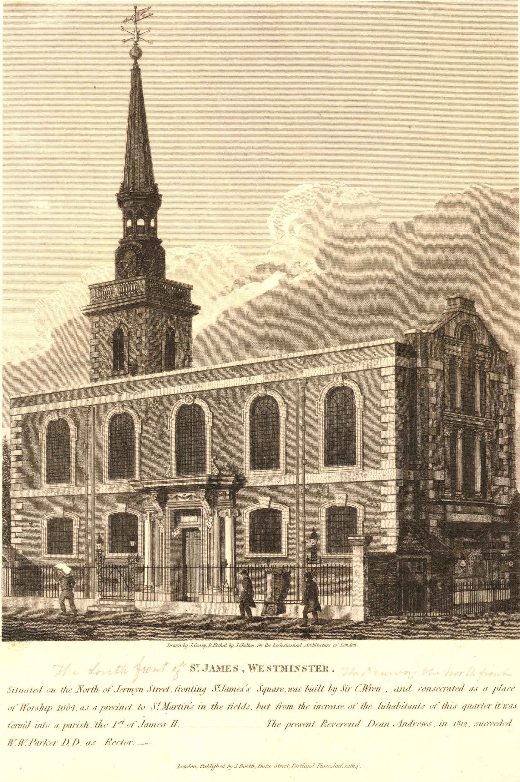
Image: © The Trustees of the British Museum. Shared under a Creative Commons Attribution-NonCommercial-ShareAlike 4.0 International (CC BY-NC-SA 4.0) licence.
The early emphasis on Westminster rather than Piccadilly may have been due to the gradual evolution of the street into a major thoroughfare.
Whilst a road described as an early “route to Reading” had existed on the current route of Piccadilly for centuries before the development of the street, it was only during the late 17th and early 18th centuries that the street was fully developed, and even in the early 18th century, the street had still not taken its existing name for the full route from what is now Piccadilly Circus to Hyde Park Corner.
As shown in the following map from 1720, the stretch to the east of the church was known as “Pickadilly” and to the west of the church, the road was “Portugal Street”:

Image: © The Trustees of the British Museum. Shared under a Creative Commons Attribution-NonCommercial-ShareAlike 4.0 International (CC BY-NC-SA 4.0) licence.
Walking into the church today, it is hard to imagine the state that the church was in, 85 years ago:

Looking to the west end of the church, with the fully restored organ:
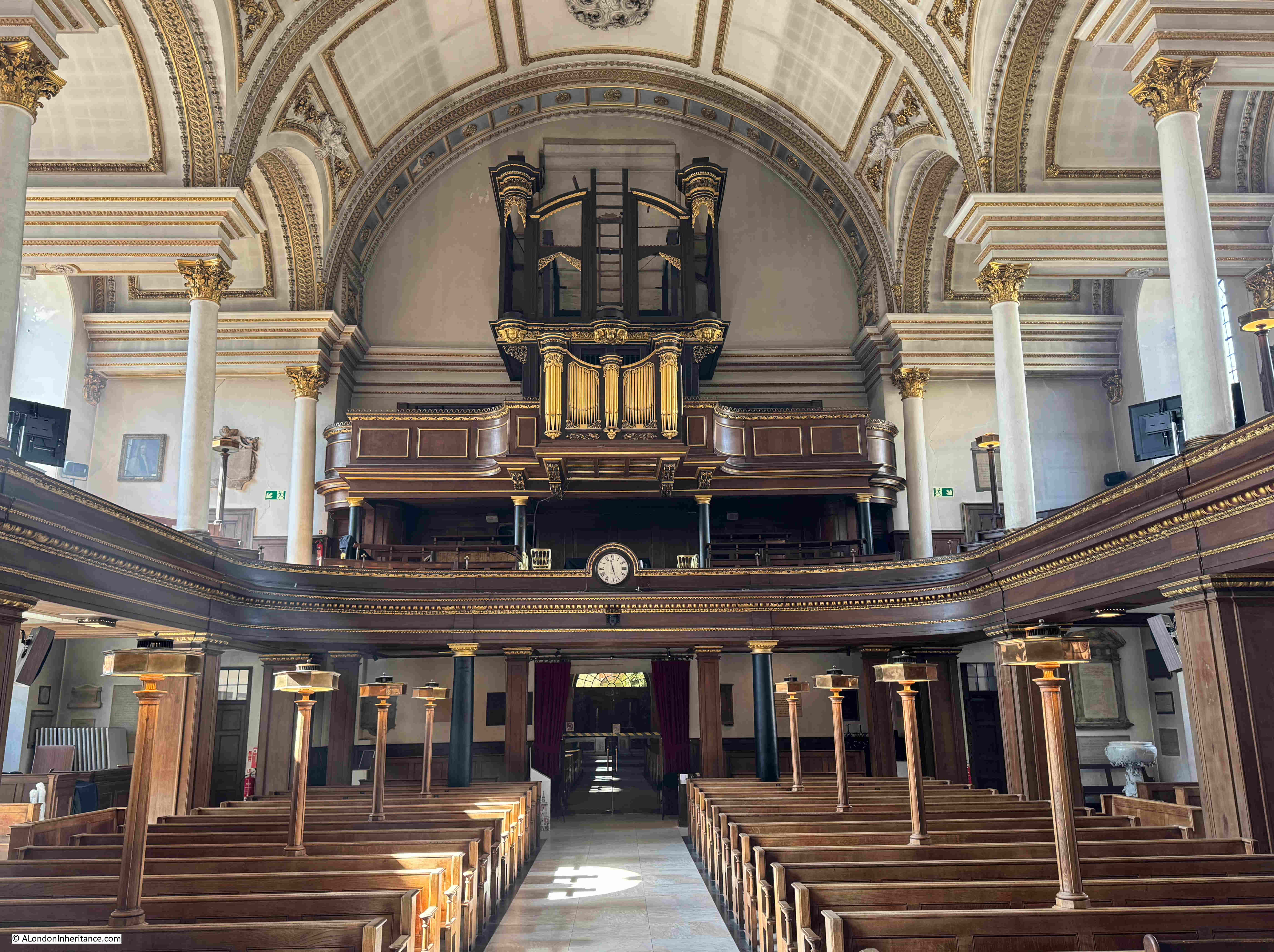
The origins of the organ date back to 1686, when an organ was built by Renatus Harris for a Roman Catholic Chapel at Whitehall Palace.
With the Protestant William of Orange and Mary (who jointly ruled as William II and Queen Mary II) coming to the throne in 1689, the Roman Catholic Chapel was dismantled, and the St. James’s vestry petitioned the Queen to have the organ from the chapel installed in their new church., as a result, the organ was moved to St. James’s, being ready to play at Christmas 1691.
The organ was restored during the late 19th century, but was badly damaged during the bombing of 1940, luckily the organ case had already been dismantled and stored remotely. It was restored and rebuilt, ready for use in 1954.
After completion, and in the first decades of the 18th century, St. James’s Piccadilly was considered the most fashionable church in London. No doubt due to the residents of the new streets around St. James’s Square, and the large houses that were built along Piccadilly, which was also growing in prominence as an important London street.
There are a lovely series of books about the Piccadilly area in wartime by the author Robert Henrey.
Robert Henrey was a journalist, however his wife was the French writer Madeleine Gal who also wrote under the name of Robert Henrey. Writing was a joint enterprise with much of the material being hers and he supplied the editorship.
They lived in Shepherd Market, and I wrote about the area in this post. In “A Village in Piccadilly” (1942), Henry wrote the following about St. James’s Church:
“I decided to attend matins at St. James’s Piccadilly. Only the south aisle remained standing after high explosives and incendiaries had rained down on both the church and the adjoining rectory during the night raids of the summer.
St. James’s was the essence of Piccadilly. Wrecked and charred, it continued to arrest the attention of the passer-by as the most spectacular ruin of the neighbourhood.
My first interest in St. James’s was when, as a child, it was pointed out to me that the steeple was sloping – a local tower of Pisa!. This had struck me so deeply that I never walked past without looking up at it with fascination. This steeple was the only part of the church for which Wren was not responsible; his original design was refused on the grounds of expense, and the work was given to a local builder.
What gave the church its picturesqueness was the open-air pulpit , the big yard paved with old tombstones that originally stood upright, and the gnarled tree that in summer spread its leafy branches over Piccadilly.”
The following photo is from the book “A Village in Piccadilly”, which shows some of the damage to the church:

There is also a short British Pathe film showing the bomb damaged church:
And this British Pathe film shows the 1946 opening of a Garden of Remembrance at the church, as well as more scenes of the considerable damage to the church in 1940:
The church has some rather unique lights mounted on the pews:

The walls of the church have a good number of monuments and plaques, and some of these record that it was not just the living who suffered wartime bombing, but also the dead.
This plaque is to William McGillivray, who died in London in 1825 and with his wife Magdalen, were buried at the church, with their graves being destroyed in 1940:

William McGillivray was a Scottish born fur trader, who spent the majority of his life in Canada, with a home in Montreal, as well as retaining a significant estate in Scotland.
McGillivray’s time with the North West Company was during the expansion of their operations across Canada, and with considerable competition with the Hudson Bay Company.
Furs were one of the major exports of both the North West and Hudson Bay Companies, and during the first decades of the 19th century, the excessive numbers of beaver trapped for their furs was leading to the scarcity of what had been a common animal. Many of the furs exported by the North West Company would have been traded through the Port of London.
The fur trade from Canada was gradually replaced by timber as in 1809 Napoleon had blockaded the Baltic Sea which prevented timber being exported to the UK, and in the same year, the countries other main source of timber, the United States enacted their Non-Intercourse Act, which prohibited trade with the UK – an act which did contribute to the industrialisation of the United States as for the time that the act was in place, British manufactured goods could not be imported into the US – a parallel with recent US tariffs perhaps?
His death in London was during a visit, rather than when living in the city.
Another grave destroyed in 1940 was that of Bartholomew Ruspini, who apparently in 1788 established the “Royal Cumberland Freemason School for the Daughters of Deceased or Distressed Freemasons”:

The school is still going, and is based in Rickmansworth, although judging by their fees, it does not look as if it would cover the daughters of those in financial distress.
Another of the graves or tombs destroyed in 1940 was that of Mary Beale, who unusually for the time, was a portrait painter:

According to the National Portrait Gallery, Mary was the daughter of a Suffolk clergyman who married Charles Beale, who was an artists colour-man – a person who made and prepared the materials that an artist would use.
She had a studio in London and produced a considerable number of portraits, and the National Gallery records her as being the earliest professional female artist in their collection.
Mary Beale – a self portrait:

Image source: © National Portrait Gallery, London and reproduced under Creative Commons licence CC BY-NC-ND 3.0.
In her portrait, Mary is holding in her right hand a portrait of her two sons, and on the wall on the left is an artist’s pallet, highlighting both her family and her profession.
Mary’s portrait is believed to date from 1666 – the same year as the Great Fire of London. No connection – just interesting to see an image of someone who may have witnessed such a disastrous event in the history of London.
A memorial to two other artists who were buried in the church. The Dutch marine artists William van der Velde the Elder, and his son William van de Velde the Younger:

Father and son van de Velde left Amsterdam in 1672 and settled in England. They became favourites of King Charles II, who, to encourage them to stay, provided studio space in the Queen’s House in Greenwich, as well as a salary of £100 each, a year.
The van der Velde’s established maritime art as a key part of Britain’s maritime identity, at a time when trade via the sea was rising rapidly, as well as the strength of the Royal Navy.
The Royal yacht ‘Cleveland’ by William van de Velde the Younger:

Image: © The Trustees of the British Museum. Shared under a Creative Commons Attribution-NonCommercial-ShareAlike 4.0 International (CC BY-NC-SA 4.0) licence.
A sample of some of the original monuments in the church. This is to Master Henry Nesbitt Brooke who died in Hammersmith at the age of 11 and was described as “A Most Promising Youth”:

Looking at some of the monuments, you do wonder about the history of the people recorded. Henry died in London in 1823 at the age of 11, and had been born on the Island of St. Helena.
St. Helena is the very remote island in the southern Atlantic, where Napoleon Bonaparte was held from his surrender in 1815 to his death in 1821.
The plaque does not record when Henry left St. Helena, but it is possible that he was on the island at the same time as Napoleon, and that they may have met.
The “artist, poet, visionary” William Blake, who was baptised in St. James’s in 1757:

William Yarrell – Treasurer and a Vice President of the Linnean Society of London:

The Linnean Society was founded in 1788 at a learned society devoted to the science of natural history.
The monument is a memorial to Yarrell, as he was not buried at St. James’s. Yarrell died in 1856, and I assume his memorial is at St. James’s as during the following year, 1857, the Linnean Society moved from Soho Square to Burlington House in Piccadilly (the current location of the society), so by the time the monument was completed, it was installed in the church nearest to the home of the society.
The font:

The font is believed to be the work of Grinling Gibbons, and dates from 1686. The font is of white marble. Gibbons is usually known for his work with carved wood, for example with the decoration on the reredos (wooden panels) behind church altars (such as the panels in St. James’s), but he was also exceptionally skilled at marble work as the ornate font demonstrates.
The font originally had a cover, however it is believed that this was sold by the church, possibly in 1822, when the font was moved to a location where the cover could not be hung.
The following print is from 1718 and lists Grinling Gibbons as the sculptor of the font, and also shows the ornate cover that was part of its original design and installation:

Image: © The Trustees of the British Museum. Shared under a Creative Commons Attribution-NonCommercial-ShareAlike 4.0 International (CC BY-NC-SA 4.0) licence.
The courtyard of the church, between the church and Piccadilly is where the high explosive bomb fell in 194o, and that did so much damage to the church. Today, it is busy place with food stalls and people taking a lunchtime break:

The Grade II listed Southwood memorial located between the courtyard and the garden to the west of the church:

The memorial is to Viscount Southwood, who died in 1946 and bequeathed money for the memorial garden, the opening of which is shown in one of the British Pathe films shown earlier in the post.
A walk along Church Place to the east of the church, shows the eastern end of the church, whare the altar is located:

Church Place from Piccadilly:

St. James’s Church is a lovely late 17th century London church, which tells the story of the westward expansion of London, how the building of new streets and significant increases in population required the division of parish boundaries into smaller areas, as what had been fields disappeared.
A church that looked almost a lost cause after the bombing of 1940, but too important not to be rebuilt, and as Robert Henrey / Madeleine Gal wrote in 1942 – the Essence of Piccadilly.